Nature Accelerated Article Preview
The effect of large-scale anti-contagion-policies on the COVID-19 pandemic
Governments around the world are responding to the novel coronavirus (COVID-19) pandemic1 with unprecedented policies designed to slow the growth rate of infections. Many actions, such as closing schools and restricting populations to their homes, impose large and visible costs on society, but their benefits cannot be directly observed and are currently understood only through process-based simulations2–4. Here, we compile new data on 1,717 local, regional, and national non-pharmaceutical interventions deployed in the ongoing pandemic across localities in China, South Korea, Italy, Iran, France, and the United States (US). We then apply reduced-form econometric methods, commonly used to measure the effect of policies on economic growth5,6, to empirically evaluate the effect that these anti-contagion policies have had on the growth rate of infections. In the absence of policy actions, we estimate that early infections of COVID-19 exhibit exponential growth rates of roughly 38% per day. We find that anti-contagion policies have significantly and substantially slowed this growth. Some policies have different impacts on different populations, but we obtain consistent evidence that the policy packages now deployed are achieving large, beneficial, and measurable health outcomes. We estimate that across these six countries, interventions prevented or delayed on the order of 62 million confirmed cases, corresponding to averting roughly 530 million total infections. These findings may help inform whether or when these policies should be deployed, intensified, or lifted, and they can support decision-making in the other 180+ countries where COVID-19 has been reported7.
Our Infrastructure Is Being Built for a Climate That’s Already Gone
Our drain pipes, reservoirs, power lines, roads, sewage systems, and more are all designed based on past climate data. But with the climate crisis comes the uncomfortable realization that the past can’t predict what we’ll need in the future.
by Shayla Love
Jun 2 2020, 1:05pm
In 1979, the Army Corps of Engineers predicted that by 2014, Optima Lake, in the panhandle of Oklahoma, would have 600,000 visitors a year camping, fishing, boating, and swimming. Instead, the lake sat empty, a dry expanse of land about three miles long. Today, it is still abandoned.
The Optima Lake and Dam was originally intended to control flooding from Beaver Creek and the North Canadian River. After $45 million was spent on its construction, though, the lake never filled up, and it has never reached more than 5 percent of its capacity.
Ed Rossman, a planning branch chief for the Corps of Engineers’ Tulsa District, told a local NPR station in 2013 that the project had been led astray because planners used historical climate data to pick the spot where the dam would be built. That data was wrong by the time construction was completed, and the water no longer flowed there. “We know that the historic record may not be a good snapshot for the future,” Rossman said.
In other parts of the world, the opposite problem has occurred. A flooding barrier put up in the 1990s in the Netherlands to protect Rotterdam will likely fail 25 years sooner than was predicted when it was first built in the 1990s. Replacing the barrier will cost around a billion euros, 10 million of which would be just the cost for taking it down.
The issue here, in its different guises, is one that engineers and city planners continue to face, and which reveals an inherent problem with how we’ve planned, designed, built, and made predictions around all of our infrastructure. At its core, this problem revolves around a concept called stationarity.
The tropics lost 11.9 million hectares (46,000 square miles) of tree cover, the study found, 3.8 million in older, primary forest areas – the third highest loss of primary trees since 2000 and a slight increase on 2018.
“The level of forest loss that we saw in 2019 is unacceptable,” Frances Seymour, from the World Resources Institute, said.
“And one of the reasons that it’s unacceptable is that we actually already know how to turn it around.
“If governments put into place good policies and enforce the law, forest loss goes down.
“But if governments relax restrictions on burning, or [are] signalling that they intend to open up indigenous territories for commercial exploration, forest loss goes up.”
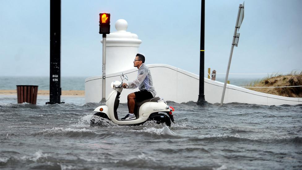
Just down the coast from Donald Trump’s weekend retreat, the residents and businesses of south Florida are experiencing regular episodes of water in the streets. In the battle against rising seas, the region – which has more to lose than almost anywhere else in the world – is becoming ground zero.
Stationarity is the idea that, statistically, the past can help you predict and plan for the future—that the variations in climate, water flow, temperature, and storm severity have remained and will remain stationary, or constant.
Nearly all the infrastructure decisions with which we live have been made with the assumption of stationarity. Engineers make choices about stormwater drainage pipes based on past data of inches of rain. Bridge engineers design foundations that can withstand a certain intensity of water flow based on the severity a certain location has experienced in the past. Reservoirs are designed to hold water based on historical information about water flow, and the historical water needs of a community.
Brazil accounted for a third of it, its worst loss in 13 years apart from huge spikes in 2016 and 2017 from fires.
However, Indonesia and the Democratic Republic of Congo both managed to reduce tree loss.
Meanwhile, Australia saw a sixfold rise in total tree loss, following dramatic wildfires late in 2019, .
As well as storing massive amounts of carbon, primary, tropical rainforests, where trees can be hundreds or even thousands of years old, are home to species such as orangutans and tigers.
The first time my father’s basement flooded, it was shortly after he moved in. The building was an ocean-front high-rise in a small city north of Miami called Sunny Isles Beach. The marble lobby had a waterfall that never stopped running; crisp-shirted valets parked your car for you. For the residents who lived in the more lavish flats, these cars were often BMWs and Mercedes. But no matter their value, the cars all wound up in the same place: the basement.
When I called, I’d ask my dad how the building was doing. “The basement flooded again a couple weeks ago,” he’d sometimes say. Or: “It’s getting worse.” It’s not only his building: he’s also driven through a foot of water on a main road a couple of towns over and is used to tiptoeing around pools in the local supermarket’s car park.
Ask nearly anyone in the Miami area about flooding and they’ll have an anecdote to share. Many will also tell you that it’s happening more and more frequently. The data backs them up.
It’s easy to think that the only communities suffering from sea level rise are far-flung and remote. And while places like the Solomon Islands and Kiribati are indeed facing particularly dramatic challenges, they aren’t the only ones being forced to grapple with the issue. Sea levels are rising around the world, and in the US, south Florida is ground zero – as much for the adaptation strategies it is attempting as for the risk that it bears.
Florida State Road A1A runs the entire length of Florida along the ocean, making it vulnerable to flooding – as shown here in Fort Lauderdale in 2013 (Credit: Alamy)
One reason is that water levels here are rising especially quickly. The most frequently-used range of estimates puts the likely range between 15-25cm (6-10in) above 1992 levels by 2030, and 79-155cm (31-61in) by 2100. With tides higher than they have been in decades – and far higher than when this swampy, tropical corner of the US began to be drained and built on a century ago – many of south Florida’s drainage systems and seawalls are no longer enough. That means not only more flooding, but challenges for the infrastructure that residents depend on every day, from septic tanks to wells. “The consequences of sea level rise are going to occur way before the high tide reaches your doorstep,” says William Sweet, an oceanographer at the National Oceanic and Atmospheric Administration (NOAA).
The flooding would be a challenge for any community, but it poses particular risks here. One recent report estimated that Miami has the most to lose in terms of financial assets of any coastal city in the world, just above Guangzhou, China and New York City. This 120-mile (193km) corridor running up the coast from Homestead to Jupiter – taking in major cities like Miami, Fort Lauderdale and West Palm Beach – is the eighth most populous metropolitan area in the US. It’s also booming. In 2015, the US Census Bureau found that the population of all three counties here was growing – along with the rest of Florida – at around 8%, roughly twice the pace of the US average. Recent studies have shown that Florida has more residents at risk from climate change than any other US state.
by Daniel Brouse
March 25, 2020
Email: help@membrane.com
Abstract: Many compromised respiratory and immune systems are a result of air pollution. COVID-19 is having a larger impact on the population due to underlying compromised respiratory and immune systems caused by air pollution.
Hypothesis:
Large portions of the world are susceptible to particulate and ozone pollution. In this study, the focus is on particulate pollution. Though tropospheric ozone pollution is thought to be more detrimental to the respiratory and immune systems, current technology makes it too difficult to measure. Tropospheric ozone and particulate pollution are common in urban and industrial areas. Ozone is created when the ultraviolet light, temperature, and chemicals in the air create a chemical reaction. The result is millions of micro-explosions in the lungs. Hot summer days are optimal for ozone creation. Particulate pollution is a result of fine particles suspended in the atmosphere. Particulate pollution is easier to be aware of because you can see it as haze or smog in the air. Exposure to ozone and particulate pollution results in permanent lung damage and chronic immune system disorders. Exercising in the out-of-doors during days with high pollution amplifies the damage to the respiratory and immune systems. The larger the pollution intake, the more severe the damage.
Exposure to air pollution and COVID-19 mortality
The Harvard study Fine particulate matter and COVID-19 mortality in the United States found, “A small increase in long-term exposure to PM2.5 leads to a large increase in COVID-19 death rate, with the magnitude of increase 20 times that observed for PM2.5 and all-cause mortality. The study results underscore the importance of continuing to enforce existing air pollution regulations to protect human health both during and after the COVID-19 crisis. The data and code are publicly available.” [1]
A study from Oxford found, “Our results suggest that air pollution is an important cofactor increasing the risk of mortality from COVID-19. This provides extra motivation for combining ambitious policies to reduce air pollution with measures to control the transmission of COVID-19.” [2]
“The study estimated that about 15% of deaths worldwide from COVID-19 could be attributed to long-term exposure to air pollution. In Europe the proportion was about 19%, in North America it was 17%, and in East Asia about 27%,” reports the European Society of Cardiology. [3]
The research showed that airborne pollen on average accounts for 44% of the variation in infection rates in addition to humidity and air temperature. Pollen exposure weakens the immunity by diminishing the antiviral interferon response.
“The presence of wildfire smoke last year during the pandemic may have been responsible for at least 19,000 additional cases of COVID-19 on the West Coast, and 700 subsequent deaths.”
“The year 2020 brought unimaginable challenges in public health, with the confluence of the COVID-19 pandemic and wildfires across the western United States. Wildfires produce high levels of fine particulate matter (PM2.5). Recent studies reported that short-term exposure to PM2.5 is associated with increased risk of COVID-19 cases and deaths. We acquired and linked publicly available daily data on PM2.5, the number of COVID-19 cases and deaths, and other confounders for 92 western U.S. counties that were affected by the 2020 wildfires. We estimated the association between short-term exposure to PM2.5 during the wildfires and the epidemiological dynamics of COVID-19 cases and deaths. We adjusted for several time-varying confounding factors (e.g., weather, seasonality, long-term trends, mobility, and population size). We found strong evidence that wildfires amplified the effect of short-term exposure to PM2.5 on COVID-19 cases and deaths, although with substantial heterogeneity across counties.”
Negative Feedback Loops
Long term exposure to air pollution causes COVID co-morbidities including respiratory disease, cardiovascular disease, and a compromised immune system. Contracting COVID exacerbates the preexisting co-morbidities. Post-COVID exposure to air pollution further compromises the co-morbidities. The negative feedback loop repeats until failure.
* The evidence shows that reinfection further increases risks of death, hospitalization and damage to multiple organ systems
* COVID exacerbates underlying conditions including pulmonary, cardiovascular, hematological, diabetes, gastrointestinal, kidney, mental health, musculoskeletal and neurological disorders
First infection with severe acute respiratory syndrome coronavirus 2 (SARS-CoV-2) is associated with increased risk of acute and postacute death and sequelae in various organ systems. Compared to no reinfection, reinfection contributed additional risks of death, hospitalization, and sequelae including pulmonary, cardiovascular, hematological, diabetes, gastrointestinal, kidney, mental health, musculoskeletal and neurological disorders. The risks were evident regardless of vaccination status. The risks were most pronounced in the acute phase but persisted in the postacute phase at 6 months. Compared to noninfected controls, cumulative risks and burdens of repeat infection increased according to the number of infections. Limitations included a cohort of mostly white males. The evidence shows that reinfection further increases risks of death, hospitalization and sequelae in multiple organ systems in the acute and postacute phase. Reducing overall burden of death and disease due to SARS-CoV-2 will require strategies for reinfection prevention.
Minimize Your Risk
1) Minimize your exposure to air pollution by checking the air quality conditions in your location. (Get air quality data where you live.)
2) People at high risk of COVID mortality due to co-morbidities, such as, aged, obese and type2 diabetics, combined with long term exposure to air pollution should take preventative measures. A deficiency of nicotinamide adenine dinucleotide (NAD+) may be the primary factor related to the SARS-Cov-2 disease spectrum and the risk for mortality, as subclinical nutritional deficiencies may be unmasked by any significant increase in oxidative stress. [4]
Scientists have found a new point of major vulnerability in the Antarctic ice sheet, in a region that already appears to be changing as the climate warms and has the potential to raise sea levels by nearly five feet over the long term.
Denman glacier, in East Antarctica, is a 12-mile-wide stream of ice that flows over the deepest undersea canyon in the entire ice sheet before spilling out into the ocean. That subsea trough is more than 2 miles deep, or double the average depth of the Grand Canyon. While there are far deeper trenches in the open ocean, such as the Marianas Trench, in this case the extreme undersea topography lies right on the outer fringe of the Antarctic continent — making it the “deepest continental point on Earth.”
That deep canyon is a potential pathway for the ocean to infiltrate deep into Antarctica’s center — posing a threat of significant sea level rise.
AD
Denman glacier, which fills the submerged canyon with extremely thick ice, has begun to respond to climate change. It is creeping backward down a slope that plunges into these extreme depths, new research finds, potentially igniting a feedback process that could ultimately unload trillions of tons of ice into the ocean.
“The configuration of the bed of the glacier makes this one of the weakest spots in east Antarctica,” said Virginia Brancato, a NASA scientist who was the lead author of the new study in Geophysical Research Letters. “If I have to look at East Antarctica as a whole, this is the most vulnerable spot in the area.”
So far, scientific attention has been mostly trained on the West Antarctic ice sheet. That’s because several glaciers in West Antarctica — most of all, the enormous Thwaites glacier, the subject of a multimillion dollar international research mission — have been losing ice rapidly as they are undercut by warm ocean water.
AD
But East Antarctica has the potential to release more ice, and some of its glaciers may be vulnerable to the same process affecting the glaciers in West Antarctica, which scientists refer to as “marine ice sheet instability.”
“The ice reservoir in East Antarctica is nine times that of the West Antarctic ice sheet,” said Helen Amanda Fricker, a glaciologist at the Scripps Institution of Oceanography who was not involved in the current study, but reviewed it for The Washington Post. “So when its contribution kicks in, it will be noticeable in future sea level rise.”
The race is on to find the vulnerable spots in East Antarctica — and with the new research, Denman glacier tops the list.
“This study provides additional evidence that, based on current knowledge, we cannot exclude at least a slight possibility of much more sea-level rise than the most-likely value in [Intergovernmental Panel on Climate Change] projections,” said Richard Alley, a glaciologist at Pennsylvania State University who did not work on the study.
The study used satellite techniques to determine the “grounding line” of Denman glacier has retreated inland more than 3 miles toward the center of Antarctica in the past 20 years.
Bed topography under the Denman Glacier in Antarctica colored by the elevation. Areas below sea level are colored in shades of blue while areas above sea level are colored in green, yellow and brown. (NASA Scientific Visualization Studio)
The “grounding line” of a marine glacier, such as Denman, is the point deep beneath the sea surface where ocean, bedrock and ice all meet. Farther outward from the grounding line, the ice is afloat and no longer touching bedrock. Farther inland, the ice no longer has contact with the ocean.
AD
If a grounding line is moving backward, more ice is floating, and the ocean is penetrating further inland with the glacier in retreat. That’s what’s happening at Denman, scientists say.
In this case, the grounding line has not only moved backward, but it has also moved down a steep slope into the two-mile-deep canyon atop which the glacier sits. This means the ice front that the glacier presents to the ocean has gotten thicker. It is more than a mile thick, but it has the potential to increase to two miles of thickness if the glacier backs fully into the depths.
Scientists describe this type of glacier configuration as a “retrograde slope” and have determined it can lead to a runaway feedback process in which ice loss begets more and more ice loss. The more the glacier’s grounding line backs down the slope, the thicker the ice becomes. This means the ice can flow outward faster and also that more of it will be exposed to ocean waters capable of melting it.
AD
“In this configuration, it means that once the glacier starts retreating, it’s very hard to stop it,” said Eric Rignot of the University of California, Irvine, one of the study’s authors. “You sort of open the floodgates.”
Elephant seals fitted with sensors on their heads have been used to take measurements of the water temperatures off the coast of Denman glacier. The resulting readings show temperatures more than sufficient to melt ice, around -1 degrees Celsius, in the ocean offshore at about 300 meters of depth. If that water is making its way beneath the glacier’s floating portion, its “ice tongue,” and all the way to the grounding line, the melting potential would be high and explain why Denman already is in retreat.
“We have the indirect signature of that warm water by the fact that the ice is melting from the bottom at relatively high rates compared to the rest of East Antarctica,” said Rignot.
AD
Denman already has lost over 250 billion tons of ice, researchers have calculated, equivalent to a little over half a millimeter of sea level rise. But there are 540 trillion tons of ice loss potential if the glacier were to travel backward across the entire subterranean canyon — a distance of nearly 100 miles. At this point, the melting could then reach a critical area of Antarctica called the Aurora Subglacial Basin.
Here, enormous volumes of ice rest on a bed well below sea level. If the ocean gets into the Aurora Basin due to the loss of Denman glacier, there is the potential for nearly five feet of sea level rise.
It’s unclear how fast this dynamic could play out. In a region with a complex and little understood undersea topography, it’s unknown how much warm water is making it to the base of Denman, and that makes a huge difference, said Donald Blankenship, a glaciologist at the University of Texas at Austin who has conducted extensive research on East Antarctica.
AD
“What they’ve proven is there is a path for that warm water to get to the grounding zone. They have proven existence, not sensitivity,” Blankenship said. “And that’s important.”
Experts pointed out another key factor that could slow Denman’s ice loss. The pathway into the deep canyon appears to be relatively narrow, with extremely high and steep rock walls that will provide friction that could slow the ice flow.
“The situation is quite complex, with the steep retrograde slope and great depth favoring instability, but the narrow fjord, as the authors point out, perhaps favoring slower changes or even restabilization,” Alley said.
For now, scientists cannot say how rapidly Denman is likely to lose ice — only that it is already doing so and shows a worrying geometry.
“All the elements that are there,” said Brancato. “The bed topography and the melt rates that we observe very close to the grounding line make it the perfect recipe for the glacier to keep on retreating.”
A new report by Climate Central presents the potential impacts due to flooding from projected sea-level rise on coastal communities around the world. This is based on its new digital elevation model called Portfolio Analysis Tool (PAT). The results are useful for planning, but even before it was released Boston and New York City had already taken actions to plan and mitigate sea-level rise impacts, and Florida recently appointed its first Chief Resilience Officer. Other coastal communities, large and small, would do well to follow those examples and consider the future presented in the Climate Central report.
There are a few undeniable truths about our current situation that underscore the need to act. First, sea level is rising, and it is rising at an accelerating pace in many locations. We can see this in the observational record provided by tide gauges up and down our coasts, as well as in the projections generated by any number of computer models. Second, the exact amount and rate of rise is both difficult to predict and highly variable depending on any number of local and regional factors.
New Jersey will become the first state to require that builders take into account the impact of climate change, including rising sea levels, in order to win government approval for projects, Gov. Philip D. Murphy announced on Monday.
The move by Mr. Murphy, a Democrat, is part of a widening effort by states to use regulations to address worsening climate conditions and to aggressively counteract the Trump administration’s push to roll back environmental regulations.
“This is not abstract for us,” Mr. Murphy said in an interview. “This is real. The dangers are there.”
New Jersey’s initiative is believed to be the broadest, and most specific, attempt to leverage land-use rules to control where and what developers can build, and to limit the volume of emissions that are spewed into the air.
“It gives us the ability to say no, or to say, ‘You have to do it differently,’” said Kathleen Frangione, the governor’s chief policy adviser.
Mr. Murphy, through executive order, will require the state Department of Environmental Protection to begin the process of drafting new regulations to be adopted by January 2022. The changes do not require legislative approval, but could face legal and political challenges.
Flood insurance is obtained through the government’s flood insurance program
Flood insurance does not cover the basement of a house
Flood insurance covers a lifetime maximum of $250,000 in coverage
This means if you make a claim for $150,000 the maximum coverage for the life of the property drops to $100,000.
The $3.8-trillion municipal-bond market has found a new tool in its effort to understand the effects of climate change: satellites orbiting Earth.
Assessing climate risks is a particularly vexing problem given that U.S. state and local governments tend to give investors information that’s too little or just too late. But the use of geospatial data and information from sources such as Google Earth could help municipal bond investors evaluate and price the risks posed from a warming climate, rising sea levels and natural disasters.
“Largely, finance lives in columns and rows in Excel spreadsheets — climate change is not a row-and-column exercise,” said Chris Goolgasian, director of climate research at Wellington Management, a Boston asset manager that uses mapping technology to consider the effects of climate change on investments including municipal bonds. “It’s much more powerful to see it visualized.”
Air pollution is responsible for nearly half of all childhood asthma cases in Barcelona, according to research published by the Barcelona Institute of Global Health (ISGlobal).
Asthma is the most common chronic childhood disease, and although it is known to be linked to air pollution, this is the first study to assess the link between asthma and the three pollutants: nitrogen dioxide (NO2), particulate matter (PM2.5) and black carbon (BC).
‘Barcelona urgently needs interventions to reduce the amount of motor-vehicle traffic, which has a negative impact on the health of the city’s children.
‘Reducing traffic does not only reduce air pollution but also reduce noise and heat island effects and increases physical activity which is all beneficial to health.’
The Dungeness crab is vital to commercial fisheries in the Pacific Northwest, but lower pH levels in its habitat are dissolving parts of its shell and damaging its sensory organs, a new study found.
Their injuries could impact coastal economies and forebode the obstacles in a changing sea. And while the results aren’t unexpected, the study’s authors said the damage to the crabs is premature: The acidity wasn’t predicted to damage the crabs this quickly.
“If the crabs are affected already, we really need to make sure we pay much more attention to various components of the food chain before it is too late,” said study lead author Nina Bednarsek, a senior scientist with the Southern California Coastal Water Research Project.”
* Coastal habitats with the steepest ocean acidification gradients are most detrimental for larval Dungeness crabs.
* Severe carapace dissolution was observed in larval Dungeness crabs along the US west coast.
* Mechanoreceptors with important sensory and behavioral functions were destabilized.
* Dissolution is negatively related to the growth, demonstrating energetic trade-offs.
* 10% dissolution increase over the last two decades estimated due to atmospheric CO2.
“Their results suggest that coastal regions will be far from the only ones affected by sea-level rise. A huge number of counties far from the coast—some deep in the US interior—will see dramatic changes in the number of people relocating there.”
The United States is rich enough, industrialized enough, and far enough from the tropics that the rising temperatures of our changing climate aren’t going to make any place uninhabitable. But a side effect of those rising temperatures—rising oceans—most certainly will. Already, an ever-growing list of places is facing what’s called “nuisance flooding,” in which even a high tide can leave streets underwater. Major storms just make matters worse. And, by the end of this century, the expected rise of the oceans may be over five times what we saw last century.
As a result of this, many areas of the country will simply become uninhabitable, lost to the sea. Well over a third of the United States’ population lives in counties that are currently on the coast, and over 10 million currently live on land that will be lost to a sea-level rise of 1.8 meters. They’ll have to go somewhere—and people who might otherwise move to the coast will have to find some place else to relocate. All of which will change the dynamics of the typical relocation of people within the US.
A new study released in PLOS ONE tries to estimate what that will mean for the rest of the country. Their results suggest that coastal regions will be far from the only ones affected by sea-level rise. A huge number of counties far from the coast—some deep in the US interior—will see dramatic changes in the number of people relocating there.”
PLOS ONE reports, Modeling migration patterns in the USA under sea level rise. “Sea level rise in the United States will lead to large scale migration in the future. We propose a framework to examine future climate migration patterns using models of human migration. Our framework requires that we distinguish between historical versus climate driven migration and recognizes how the impacts of climate change can extend beyond the affected area. We apply our framework to simulate how migration, driven by sea level rise, differs from baseline migration patterns. Specifically, we couple a sea level rise model with a data-driven model of human migration and future population projections, creating a generalized joint model of climate driven migration that can be used to simulate population distributions under potential future sea level rise scenarios. The results of our case study suggest that the effects of sea level rise are pervasive, expanding beyond coastal areas via increased migration, and disproportionately affecting some areas of the United States.”
Flood insurance is obtained through the government’s flood insurance program
Flood insurance does not cover the basement of a house
Flood insurance covers a lifetime maximum of $250,000 in coverage
This means if you make a claim for $150,000 the maximum coverage for the life of the property drops to $100,000.