bookmark_borderClimate Change, Inflation, and You

Currently, a major contributor to inflation is the surge in homeowners’ insurance costs, propelled by the unprecedented number of climate disasters in 2023. California, Louisiana, and Florida are now dependent on government assistance to manage the financial burden of residential property insurance.

Flood insurance will become expensive and difficult to obtain.

NOAA: A historic year of U.S. billion-dollar weather and climate disasters

In 2023, the U.S. experienced 28 separate weather and climate disasters costing at least 1 billion dollars. That number puts 2023 into first place for the highest number of billion-dollar disasters in a calendar year and included:

  • 1 winter storm/cold wave event (across the northeast U.S. in early-February).
  • 1 wildfire event (firestorm destroying town of Lahaina on Maui Island of Hawaii).
  • 1 drought and heat wave event (focused across the central and southern U.S.).
  • 4 flooding events (in California, Florida, and across the eastern and northeastern U.S.).
  • 2 tornado outbreaks (across the central and eastern U.S.).
  • 2 tropical cyclones (Idalia in Florida and Typhoon Mawar in Guam).
  • 17 severe weather/hail events (across many parts of the country).

2023 was also deadly, causing at least 492 direct or indirect fatalities — the 8th most disaster-related fatalities for the contiguous U.S. since 1980.

* Our climate model employs chaos theory to comprehensively consider human impacts and projects a potential global average temperature increase of 9 degrees Celsius above pre-industrial levels.

What Can I Do?
There are numerous actions you can take to contribute to saving the planet. Each person bears the responsibility to minimize pollution, discontinue the use of fossil fuels, reduce consumption, and foster a culture of love and care. Be a butterfly and affect the world. The Butterfly Effect illustrates that a small change in one area can lead to significant alterations in conditions anywhere on the globe. Hence, the frequently heard statement that a butterfly in China can cause a hurricane in the Atlantic.

Here is a list of additional actions you can take.

How is All Real Estate at Risk From Climate Change?

bookmark_borderHow is All Real Estate at Risk From Climate Change?

By Daniel Brouse and Sidd Mukherjee

Climate change poses risks to real estate in the United States in various ways, and these risks can affect property values, insurance costs, and overall property resilience. Here are some ways in which all US real estate is at risk from climate change:

  1. Sea Level Rise and Coastal Properties:
    • Coastal properties are particularly vulnerable to sea level rise, storm surges, and coastal erosion. As sea levels continue to rise due to global warming, properties near coastlines may experience increased flooding and damage from more frequent and severe storms. Storm surges in Florida are an example.
  2. Extreme Weather Events:
    • Climate change is contributing to an increase in the frequency and intensity of extreme weather events, such as hurricanes, wildfires, floods, and droughts. Properties in regions prone to these events are at risk of damage, destruction, and increased insurance costs.
  3. Temperature Extremes:
    • Rising temperatures can lead to more frequent and prolonged heatwaves, affecting property infrastructure, energy demand, and potentially decreasing property values in areas with extreme heat.
  4. Changes in Precipitation Patterns:
    • Changes in precipitation patterns, including increased violent rainfall or prolonged droughts, can impact properties by causing flooding, landslides, or water scarcity. These changes may affect property values and increase maintenance costs.
  5. Wildfires:
    • Increased temperatures and changing precipitation patterns contribute to the risk of wildfires. Properties in wildfire-prone areas face threats to both their physical structures and the surrounding environment.
  6. Homeowners and Flood Insurance Costs:
    • Flood insurance will become expensive and difficult to obtain. Climate-related risks can lead to higher insurance premiums and deductibles, particularly in high-risk areas. As the frequency and severity of climate-related events increase, insurance companies may reassess risk models and adjust pricing accordingly.
  7. Infrastructure Vulnerability:
    • Climate change can impact infrastructure such as roads, bridges, and utilities. Properties relying on vulnerable infrastructure may face challenges related to accessibility, reliability, and potential increases in repair and maintenance costs.
  8. Health Risks:
    • Humans will experience greater loss and damage to life and quality of life from air pollution, decreasing supply of potable water, extreme weather events, and disease. The greatest short term climate change risk to human health is deadly humid heat (wet-bulb temperature). Climate change can affect human health, and properties in areas prone to heatwaves, air pollution, or vector-borne diseases may face increased health risks. This could influence property values and community desirability.Almost all survivors of climate-related disasters suffer from mental distress. Of those who have not experienced climate disasters, more than two-thirds of U.S. adults (68%) have reported climate change anxiety.
  9. Regulatory Changes:
    • Governments may implement stricter building codes, zoning regulations, and disclosure requirements related to climate-related risks. Non-compliance could affect property values and lead to increased costs for property owners. Loss and damage litigation against oil companies and governments will change world economics.
  10. Shifts in Property Demand:

It’s important to note that the degree of risk varies by region and property type. Some areas may experience more immediate and severe impacts, while others may be more resilient. Assessing and mitigating these risks require a comprehensive understanding of local climate vulnerabilities and the implementation of strategies to enhance property resilience. Policymakers, real estate professionals, and property owners are increasingly recognizing the importance of addressing climate risks to ensure the long-term sustainability and value of real estate assets. Thus, our recommendation to evacuate Florida now (i.e. Managed Retreat).

Create a Climate-Resilient Environment in and Around Your Home Brouse (2024)

Managed Retreat: Relocating Due to Climate Change Extreme Weather Events Brouse (2023)

Stormwater Runoff Management for Your House Brouse (2024)

Tree Extinction Due to Human Induced Environmental Stress Mukherjee and Brouse (2005-present)

Soil Degradation and Desertification Brouse (2024)

Atmospheric Rivers Mukherjee and Brouse (2022-2023)

Violent Rain and the Substrate Brouse and Laden (2024)

The Long-term Breathing Experiment Brouse (2023)

Health Impacts of Air Pollution Brouse (2023)

Plymouth Meeting, Pennsylvania and the Substrate Daniel Brouse (2023)

Real Estate Underwater: A Florida Climate Change Case Study Daniel Brouse (2023)

Climate Change Impacts on Flood Risks and Real Estate Values Sidd Mukherjee and Daniel Brouse (2023)

Real Estate and Climate Change: Stranded on an Island Daniel Brouse (2023)

Tipping Cascades, Social-Ecological Systems, and the Hottest Year in History Brouse (2024)

All About Flood Insurance Brouse and Mukherjee (1995-present)

The Age of Loss and Damage Brouse (2023)

bookmark_borderClimate Change and Chaos Theory

By Daniel Brouse
February 5, 2024

Global warming is caused by an increase in thermal energy. Atmospheric circulation together with ocean circulation is how thermal energy is redistributed throughout the world. Chaos theory offers insights into the complex, nonlinear dynamics of climate systems role in the redistribution of thermal energy. The Earth’s climate is a highly complex and dynamic system, influenced by various factors such as ocean currents, atmospheric circulation, and feedback loops.

Circulation systems of air and/or water include:
* doldrums, trade winds, horse latitudes, prevailing westerlies, polar front zone, and polar easterlies
* each hemisphere has three cells — Hadley cell, Ferrel cell and Polar cell in which air circulates through the entire depth of the troposphere
* usually each hemispheres has two jet streams — a subtropical jet stream and a polar-front jet stream
* waves, tides, currents, downwelling, upwelling move water
* there are over 24 currents — Benguela Current, California Current, Falkland Current, Labrador Current, Brazil Current, Florida Current, Gulf Stream, West Australian Current, Canary Current, Kuroshio Current, North Pacific Current, Somali Current, Antarctic Circumpolar Current, Antarctica Current, Antilles Current, Mozambique Current, North Atlantic Drift, Norwegian Current, Oyashio Current, West Wind Drift, Agulhas Current, South Equatorial Current, Humboldt or Peruvian Current, Monsoon Current
* five major ocean-wide gyres —- the North Atlantic, South Atlantic, North Pacific, South Pacific, and Indian Ocean
* thermohaline (temperature and salinity) circulation systems — Gulf Stream, Atlantic Meridional Overturning circulation (AMOC), Pacific Meridional Overturning Circulation (PMOC)
* ocean-atmosphere oscillations — La Nina / El Niño-Southern Oscillation (ENSO), Antarctic Oscillation (AAO), Arctic Oscillation (AO), Atlantic Multidecadal Oscillation (AMO),
Indian Ocean Dipole (IOD), Madden-Julian Oscillation (MJO), North Atlantic Oscillation (NAO), North Pacific Gyre Oscillation (NPGO), North Pacific Oscillation (NPO), Pacific Decadal Oscillation (PDO), Pacific-North American (PNA) Pattern

How does chaos theory explain thermal energy redistributed throughout the world?

  1. Nonlinear Dynamics:
    • Chaos theory emphasizes the nonlinear dynamics of complex systems, meaning that small changes in initial conditions can lead to disproportionately large and unpredictable outcomes. In the context of climate, this nonlinearity is evident in how the redistribution of thermal energy is influenced by factors like ocean currents and atmospheric circulation, which can exhibit chaotic behavior.
  2. Sensitive Dependence on Initial Conditions:
    • Chaos theory also highlights the concept of sensitive dependence on initial conditions, commonly known as the butterfly effect. In climate systems, small variations in initial conditions, such as temperature or atmospheric pressure, can lead to significant changes in the distribution of thermal energy over time.
  3. Complex Feedback Loops:
    • Climate systems involve intricate feedback loops, where changes in one component can influence others. These feedback loops contribute to the complexity and unpredictability of thermal energy redistribution. Chaos theory helps us understand how these feedback mechanisms can amplify or dampen the effects of perturbations in the system.
  4. Emergent Patterns:
    • Chaos theory recognizes the emergence of complex patterns from seemingly chaotic systems. In climate science, emergent patterns may include large-scale phenomena like El Niño or the Madden-Julian Oscillation, which play roles in redistributing thermal energy on a global scale.
  5. Climate Variability and Change:
    • Chaos theory is particularly relevant in studying climate variability and change. While long-term trends such as global warming are discernible, the inherent chaos in the climate system introduces variability and uncertainty, making it challenging to precisely predict how thermal energy will be redistributed over shorter timescales.
  6. Atmospheric Rivers and Droughts:
    • Atmospheric rivers are concentrated bands of moisture in the atmosphere, and their behavior is influenced by various atmospheric factors. Chaos theory comes into play when trying to predict the exact paths and intensities of atmospheric rivers, especially as small changes in initial conditions can lead to vastly different outcomes over time. Droughts result from complex interactions between atmospheric conditions, precipitation patterns, land use, and water management. Chaos theory highlights the sensitivity of drought conditions to initial conditions and the potential for nonlinear responses, making it difficult to precisely predict the onset, duration, and severity of drought events.

Complex Feedback Loops:

Complex feedback loops in climate science refer to interactions between different components of the Earth’s climate system that can amplify or dampen the effects of initial changes, leading to non-linear and often unpredictable outcomes. These feedback loops play a crucial role in shaping the behavior of the climate system and can influence various climate phenomena, including temperature changes, ice melt, and precipitation patterns.

Tipping points are Critical Milestones that directly impact the rate of acceleration in climate change by multiplying the number and intensity of feedback loops. Identifying and understanding these tipping points is crucial for climate science and policymaking. Crossing multiple tipping points could lead to a domino effect, resulting in a much more rapid and severe climate change than currently projected.

  1. Ice-Albedo Feedback:
    • As the Earth warms, ice and snow melt, reducing the surface area covered by highly reflective materials (high albedo). This leads to a decrease in the Earth’s overall reflectivity, or albedo, as darker surfaces (like open water or bare ground) absorb more solar radiation. The increased absorption of sunlight further warms the surface, accelerating ice melt in a self-reinforcing loop.
  2. Water Vapor Feedback:
    • Warmer temperatures can lead to increased evaporation of water from oceans and other bodies of water. Since water vapor is a greenhouse gas, higher atmospheric water vapor concentrations can enhance the greenhouse effect, trapping more heat and further raising temperatures. This positive feedback loop can contribute to the amplification of global warming.
  3. Carbon Cycle Feedback:
    • The carbon cycle involves the exchange of carbon dioxide (CO2) between the atmosphere, oceans, and terrestrial ecosystems. As the climate warms, it can influence processes like the release of carbon from thawing permafrost or changes in vegetation. The additional release of carbon dioxide can amplify the greenhouse effect, leading to further warming and affecting the carbon cycle in a feedback loop.
  4. Ocean Circulation Feedback:
    • Changes in temperature and salinity affect ocean circulation patterns. Alterations in ocean circulation can, in turn, influence heat distribution across the globe. For example, a slowdown in the Atlantic Meridional Overturning Circulation (AMOC) could impact regional climate patterns and further affect ocean circulation in a complex feedback loop.
  5. Vegetation-Climate Feedback:
    • Climate changes can affect vegetation patterns, altering the amount of sunlight absorbed and the release of water vapor through transpiration. Changes in vegetation cover can influence local and regional climates, creating feedback loops that may further impact ecosystems and climate patterns.
  6. Cloud Feedback:
    • Changes in temperature and atmospheric composition can affect cloud cover and properties. While clouds can both reflect sunlight and trap heat, the net effect depends on factors like cloud altitude and type. Changes in cloud cover and properties can influence the Earth’s radiation balance, creating feedback loops that can either amplify or dampen climate changes.

Chaos theory provides a framework for understanding the inherent complexity, sensitivity, and unpredictability of climate systems, including the redistribution of thermal energy. The interconnectedness of various factors and the nonlinear interactions within the Earth’s climate contribute to the intricate patterns observed in thermal energy distribution on a global scale. Climate models use principles from chaos theory to simulate these dynamic interactions.

The Earth is a climate system. Many subsystems make up our climate. Perhaps the most important factor impacting our climate is us. The biggest influence on climate change is the increase in greenhouse gas concentrations in the Earth’s atmosphere, primarily driven by human activities. The largest drivers of human induced climate change include: burning of fossil fuels, deforestation and land use, industrial processes, agriculture, waste management, and use of fluorinated gases.

Human induced climate change is an exponential component of an unordered system (chaos theory).Chaos theory plays a role in understanding the dynamics and potential unpredictability of social-ecological systems’ impact on climate change. Social-ecological systems encompass the interconnectedness of human societies and the ecosystems they are part of, and their behavior is influenced by a myriad of factors, including human activities, policies, resource use, and environmental changes. Chaos theory contributes insights into the complexity, sensitivity to initial conditions, and potential nonlinearities within these systems.

Here are several aspects in which chaos theory can be relevant to forecasting the impact of social-ecological systems on climate change:

  1. Nonlinear Interactions:
    • Social-ecological systems involve nonlinear interactions between human activities and environmental responses. Small changes in policies, resource management, or societal behaviors can lead to disproportionately large and unpredictable outcomes in terms of climate change impacts.
  2. Sensitivity to Initial Conditions:
    • The sensitivity of social-ecological systems to initial conditions highlights the importance of understanding how small changes or decisions can lead to significant and sometimes unexpected consequences over time. This sensitivity is crucial when forecasting the trajectory of climate change impacts resulting from human activities.
  3. Feedback Loops:
    • Feedback loops within social-ecological systems can amplify or dampen the effects of interventions or changes. For example, policies to reduce greenhouse gas emissions may lead to unforeseen economic or social consequences, creating feedback loops that influence climate change impacts.
  4. Emergent Properties:
    • Chaos theory recognizes emergent properties that arise from the interactions within complex systems. In the context of social-ecological systems, emergent properties may include new social norms, economic trends, or environmental patterns that affect and potentially amplify or mitigate the impacts of climate change.
  5. Thresholds and Tipping Points:
    • Social-ecological systems can exhibit thresholds and tipping points, where small changes gradually accumulate until a critical point is reached, leading to abrupt and sometimes irreversible changes. Chaos theory helps to understand the potential for sudden shifts in behavior within these systems.
  6. Adaptive Capacity:
    • Chaos theory encourages consideration of the adaptive capacity of social-ecological systems. The ability to adapt to changing conditions, learn from experiences, and adjust strategies is essential for forecasting and managing the impacts of climate change within these systems.
  7. Uncertainty and Systemic Risks:
    • Chaos theory underscores the inherent uncertainty in complex systems. Social-ecological systems are subject to systemic risks, where interconnected factors can amplify vulnerabilities. Understanding and managing these uncertainties are crucial for forecasting and responding to climate change impacts.

Incorporating chaos theory into forecasting models for social-ecological systems helps researchers and policymakers recognize the limitations of linear thinking and deterministic approaches. Embracing complexity and uncertainty can lead to more robust and adaptive strategies for addressing the multifaceted challenges posed by climate change within the context of human societies and ecosystems.

Our model attempts to adequately account for humans and forecasts an increase of 9 degrees Celsius above pre-industrial levels.

Toppled Tipping Points: The Domino Effect Brouse and Mukherjee (2023)Tipping Cascades, Social-Ecological Systems, and the Hottest Year in History Brouse (2024)
The Reign of Violent Rain Brouse and Mukherjee (2023)
The Age of Loss and Damage Brouse (2023)
Climate Change Impacts on Flood Risks and Real Estate Values Sidd Mukherjee and Daniel Brouse (2023)

bookmark_borderClimate Change, the Jet Stream, and East Coast Atmospheric Rivers

by Daniel Brouse

How is climate change impacting the jet stream and atmospheric rivers on the East Coast of the USA?

The interactions between various factors, including ocean currents, sea surface temperatures, and atmospheric circulation, contribute to the overall climate patterns experienced on the East Coast.

Climate change can influence the jet stream and atmospheric rivers, impacting weather patterns on the East Coast of the USA. Here are some key ways in which these changes may occur:

Jet Stream:

    1. Amplification and Slowing:
      • Climate change can lead to the amplification of atmospheric patterns, including the jet stream. This can result in larger north-south swings, which may contribute to more persistent weather conditions. Additionally, a warming Arctic relative to the mid-latitudes may slow down the jet stream.
    2. Stalled Weather Patterns:
      • A slower, more meandering jet stream can lead to the persistence of weather patterns, causing prolonged periods of extreme conditions such as heatwaves, cold spells, or heavy rainfall.
    3. Shifts in Track:
      • Climate change may alter the typical track of the jet stream, influencing where it tends to position itself. These shifts can impact regional weather patterns, including precipitation and temperature distributions.
    4. Increased Amplification:
      • As the Earth’s poles warm faster than the mid-latitudes, the temperature difference between the Arctic and lower latitudes decreases. This reduction in temperature gradient may lead to a more meandering and slower jet stream with larger north-south waves, a phenomenon known as “jet stream amplification.”
    5. Wavier Jet Stream:
      • The reduced temperature contrast between the Arctic and mid-latitudes can make the jet stream more susceptible to large, slow-moving waves. This wavier pattern can result in more persistent weather conditions, including prolonged periods of heatwaves, cold spells, droughts, or heavy rainfall.
    6. Increased Blocking Patterns:
      • A wavier and slower jet stream can lead to the formation of blocking patterns, where high or low-pressure systems persist in a particular location for an extended period. Blocking patterns can contribute to prolonged and extreme weather events.
    7. Slower Movement:
      • Some studies suggest that the jet stream is slowing down as a result of climate change. A slower jet stream can cause weather systems to move more slowly across the landscape, potentially intensifying the impacts of extreme events such as storms, heatwaves, or heavy rainfall.
    8. Changes in Zonal Flow:
      • The jet stream typically flows from west to east in a relatively straight line, a pattern known as zonal flow. Climate change may lead to more frequent disruptions of this zonal flow, causing the jet stream to meander and creating conditions for more extreme weather events.
    9. Impacts on Weather Extremes:
      • Changes in the jet stream can influence the occurrence and characteristics of weather extremes, including heatwaves, cold snaps, and intense storms. These changes can have significant implications for local and regional climate patterns.

    Atmospheric Rivers:

    1. Increased Moisture Content:
      • Warmer temperatures associated with climate change can enhance evaporation, increasing the moisture content of the atmosphere. This, in turn, can contribute to the development of more intense atmospheric rivers, which are channels of concentrated moisture in the atmosphere.
    2. Changes in Intensity and Frequency:
      • Climate change may lead to alterations in the intensity and frequency of atmospheric rivers. There is evidence suggesting that these phenomena could become more common and more potent, leading to heavier rainfall events and an increased risk of flooding.
    3. Altered Trajectories:
      • Changes in the jet stream’s position and behavior can influence the trajectories of atmospheric rivers. Variations in the jet stream can result in altered paths for these moisture-laden systems, affecting the regions that experience heavy rainfall and potential flooding.
    4. Extreme Weather Events:
      • Atmospheric rivers are often associated with extreme weather events, including heavy rainfall and flooding. Changes in the characteristics of atmospheric rivers due to climate change can contribute to an increased likelihood of severe weather events on the East Coast.

East Coast Atmospheric Rivers and AMOC (Atlantic Meridional Overturning Circulation) Brouse (2024)

Extreme Rainfall–surge Hazard Risk Basics and Atmospheric Rivers Brouse (2022)

West Coast Atmospheric Rivers Brouse (2023)

East Coast Atmospheric Rivers Brouse (2023)

Greenland Atmospheric Rivers Mukherjee (2023)

Owning a Shore Property and Flood Insurance

ALSO SEE:
The Reign of Violent Rain Brouse and Mukherjee (2023)
The Age of Loss and Damage Brouse (2023)
Climate Change Impacts on Flood Risks and Real Estate Values Sidd Mukherjee and Daniel Brouse (2023)

bookmark_borderAtmospheric Rivers and Coastal Erosion

Atmospheric rivers are long, narrow bands of concentrated moisture in the atmosphere that transport large amounts of water vapor. When these atmospheric rivers make landfall, they can bring heavy rainfall over an extended period, leading to increased runoff and potentially contributing to coastal erosion through several mechanisms:

  1. Intense Rainfall: Atmospheric rivers can bring intense and prolonged rainfall, leading to increased runoff from rivers and streams into the coastal areas. This influx of water can contribute to soil erosion and sediment transport, impacting coastal ecosystems.
  2. Flooding: The heavy rainfall associated with atmospheric rivers can cause inland flooding, leading to an increased discharge of water into coastal regions. This excess water can erode coastal land, especially in areas with vulnerable soils.
  3. Storm Surges: In some cases, atmospheric rivers may coincide with storm systems, leading to storm surges along the coast. Storm surges, combined with high winds and heavy rainfall, can intensify erosion along the shoreline.

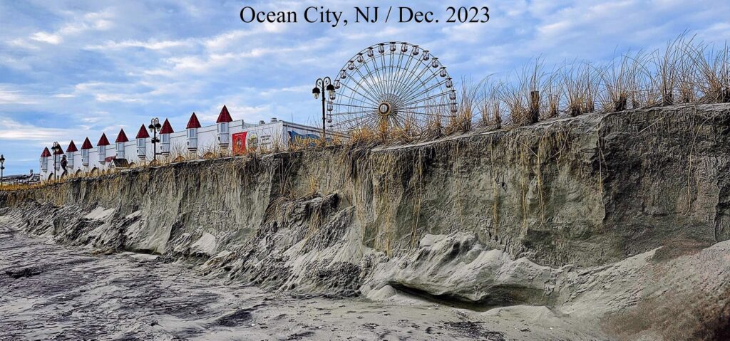
The image shows the Ocean City, New Jersey, shore after an atmospheric river coincided with storm surge.

beach erosion in Ocean City, NJ / December 2023

It’s essential to note that the impact of atmospheric rivers on coastal erosion can vary depending on local topography, land use, and other factors. Coastal erosion is a complex process influenced by a combination of natural and anthropogenic factors, including sea level rise, human activities, and changes in weather patterns.

Owning a Shore Property and Flood Insurance

Extreme Rainfall–surge Hazard Risk Basics and Atmospheric Rivers Brouse (2022)

West Coast Atmospheric Rivers Brouse (2023)

East Coast Atmospheric Rivers Brouse (2023)

Greenland Atmospheric Rivers Mukherjee (2023)

ALSO SEE:
The Reign of Violent Rain Brouse and Mukherjee (2023)
The Age of Loss and Damage Brouse (2023)
Climate Change Impacts on Flood Risks and Real Estate Values Sidd Mukherjee and Daniel Brouse (2023)

bookmark_borderClimate Change: Atmospheric Rivers

Extreme Rainfall–surge Hazard Risk Basics and Atmospheric Rivers Brouse (2022)

West Coast Atmospheric Rivers Brouse (2023)

East Coast Atmospheric Rivers Brouse (2023)

Greenland Atmospheric Rivers Mukherjee (2023)

ALSO SEE:

Real Estate and Flood Insurance Brouse and Mukherjee (1999 to present)
The Reign of Violent Rain Brouse and Mukherjee (2023)
The Age of Loss and Damage Brouse (2023)
Climate Change Impacts on Flood Risks and Real Estate Values Sidd Mukherjee and Daniel Brouse (2023)

bookmark_borderGreenland Atmospheric Rivers

by Sidd Mukherjee

Historically in the United States, atmospheric rivers (AR) have been associated with the West Coast. Now, AR activity is getting more attention on the East Coast.

Atmospheric rivers have been putting serious rainfall melt on Greenland for the last decade, too.

Darker snow surfaces absorb more sunlight and melt quicker. This effect is visible in Greenland. Box et al.,”Greenland ice sheet albedo feedback: thermodynamics and atmospheric drivers,” The Cryosphere, v6, pp821 et seq., doi:10.5194/tc-6-821-2012 state: ” Thus, intraseasonal summer albedo variability exceeds 0.50 over parts of the ice sheet where a snow layer ablates by mid-summer, exposing an impurity-rich ice surface …” Prof. Box is now investigating soot from North American wildfires as a factor in the darkening of Greenland.
— from News from the Ice Wars:An Occasional Bulletin

“Furthermore, our investigation of the short- and long-term relationships between moisture transport vents and modeled GrIS surface properties proves that this correspondence between the years of enhanced AR activity and anomalous GrIS mass loss is not a coincidence. Strong AR impacts cause increased melt in all areas of the GrIS and decreased SMB in the ablation zone during summer, and warm seasons with above-average GrIS melt extent are characterized by anomalously strong moisture transport by ARs over Greenland. ARs typically result in SMB gains in the GrIS ablation zone during nonsummer seasons and in the accumulation zone during all seasons. However, the intense summer SMB losses in the ablation zone during years of enhanced moisture transport outweigh the positive AR contributions to SMB in other regions and seasons. The scaling of melt versus snowfall in Figures 9 and 11 shows that the magnitude of mass loss from summer melt in the ablation zone has a much greater upper limit than mass gain from snowfall.”

In this paper see especially Fig. 9.

Then in 2018, Neff publishes again: more on atmospheric rivers causing the full surface melt in greenland in 2012.
— from Atmospheric River Impacts on Greenland Ice Sheet SurfaceMass Balance

“Rainfall at the Greenland ice sheet Summit 14 August 2021, was delivered by an atmospheric river (AR). Extreme surface ablation expanded the all-Greenland bare ice area to near-record-high with snowline climbing up to 788 ± 90 m. Ice sheet wet snow extent reached 46%, a record high for the 15–31 August AMSR data since 2003. Heat-driven firn deflation averaged 0.14 ± 0.05 m at four accumulation area automatic weather stations (AWSs). Energy budget calculations from AWS data indicate that surface heating from rainfall is much smaller than from either the sensible, latent, net-longwave or solar energy fluxes. ”

“Rainfall heat transfer contributed just 2% to the calculated melting at a 2,200 m elevation western ice sheet site (CP1 a.k.a. Crawford Point). Condensation or sensible heat transfer from the warm air mass was a far more powerful heat source. The observed amount of melting delivered by the AR could have happened without rain- fall. Yet, the impacts of rain and meltwater refreeze are considerable provided that percolation delivers the melt below where the heat can be radiated away and that refreeze-at-depth occurs. We found no evidence for the latter condition because the rainfall amount was not extreme and the surface was already melting hours before the rain- fall. Understanding any changes to the frequency and intensity of ARs appears to be a more important research target than the heat content of the liquid precipitation ARs may or may not produce Further, while rainfall that does not percolate and refreeze may not have strong surface thermodynamic impacts, rainfall contribution to the hydraulics of Greenland ice (Doyle et al., 2015) may be more consequential to ablation through ice sheet flow acceleration.”

open access, read all about it. The Watson river discharge described in the paper drains the saddle between north and south domes and is an area that i watch closely for signs of collapse. I suppose this is one.
— from Greenland Ice Sheet Rainfall, Heat and Albedo Feedback Impacts From the Mid-August 2021 Atmospheric River

ALSO SEE:
West Coast Atmospheric Rivers Brouse (2023)

East Coast Atmospheric Rivers Brouse (2023)

The Reign of Violent Rain Brouse and Mukherjee (2023)

The Age of Loss and Damage Brouse (2023)

Climate Change Impacts on Flood Risks and Real Estate Values Sidd Mukherjee and Daniel Brouse (2023)

bookmark_borderWest Coast Atmospheric Rivers

by Daniel Brouse

As the Earth warms, the air will hold more moisture. More moisture-laden air moves over land and creates atmospheric rivers (Pineapple Express). The Journal EOS in the article Atmospheric Rivers Spur High-Tide Floods on U.S. West Coast said, “Atmospheric rivers are narrow bands of moisture that travel across the lower troposphere, generally at the leading edges of massive low-pressure systems. At their peak, they can carry as much water through the sky as the Amazon River does on land. They unleash intense winds and heavy rain as they surge across the Pacific Ocean, eventually making landfall on the U.S. West Coast, contributing to many high-tide flooding events.”

The atmospheric rivers also bring heavy rainfall inland causing extreme flooding. In October of 2021 NOAA said, “a convergence of storms brought more than half a foot of rain to parts of the Bay area in addition to strong winds, flash floods, and mud/landslides. They also bring the potential for heavy snow to higher elevations in the Sierra Nevada mountain range.” (Atmospheric River Hits the West Coast)

In December 2022 and January 2023, California experienced nine back-to-back atmospheric rivers; the longest stretch of continuous atmospheric river conditions on record. NOAA went on to report, “Several atmospheric rivers struck in March 2023, bringing heavy rain and snowfall to much of the West. According to the California Department of Water Resources, the statewide snowpack was among the deepest ever recorded for the end of March — 237% of normal.”

In October of 2023, a tropical storm turned into category 5 Hurricane Otis in a record 12-hour intensification. Hurricane expert Kerry Emanual said Otis was supercharged by global warming. Historically, hurricanes’ intensification was driven by ocean surface temperatures. Otis was additionally supercharged by increasing temperatures deeper in the ocean. Hurricane Otis became the strongest on record to hit Mexico’s Pacific coast. NOAA reported, “When Otis first hit, mudslides outside the city in mountainous terrain prevented crews from traveling to the city to provide aid, and according to the Associated Press, the 10,000 troops that were deployed to the area lacked the tools needed to clear mud and downed trees off roads.”

ALSO SEE:
East Coast Atmospheric Rivers Brouse (2023)

The Reign of Violent Rain Brouse and Mukherjee (2023)

The Age of Loss and Damage Brouse (2023)

Climate Change Impacts on Flood Risks and Real Estate Values Sidd Mukherjee and Daniel Brouse (2023)


bookmark_borderEast Coast Atmospheric Rivers

by Daniel Brouse
December 10, 2023

As the Earth warms, the air will hold more moisture (water vapor). When more moisture-laden air moves over land it can create atmospheric rivers. In the Northwestern USA, the atmospheric rivers are commonly called the Pineapple Express. The Journal EOS in the article Atmospheric Rivers Spur High-Tide Floods on U.S. West Coast said, “Atmospheric rivers are narrow bands of moisture that travel across the lower troposphere, generally at the leading edges of massive low-pressure systems. At their peak, they can carry as much water through the sky as the Amazon River does on land. They unleash intense winds and heavy rain as they surge across the Pacific Ocean, eventually making landfall on the U.S. West Coast, contributing to many high-tide flooding events.”

Historically in the United States, atmospheric rivers (AR) have been associated with the West Coast. Now, AR activity is getting more attention on the East Coast. “Actually their frequency is not really increasing. Meteorologists have used the term for decades. It has simply become popular by the media. Just like polar vortex,” said Jeff Boyne National Weather Service meteorologist and climatologist. Indeed, “atmospheric rivers are more frequent on the East Coast than they are on the West Coast,” said Jason Cordeira, associate professor of meteorology at Plymouth State University. “They’re just not as impactful and don’t usually produce as much rainfall.”

What is changing is the research into the types and increasing intensity of East Coast AR events. “Between 1958 and 2012, the Northeast saw more than a 70% increase in the amount of rainfall measured during heavy precipitation events, more than in any other region in the United States. Projections indicate continuing increases in precipitation, especially in winter and spring and in northern parts of the region,” as reported in The US Fourth National Climate Assessment.

Most types of East Coast ARs are increasing in intensity likely due to climate change. The study Identifying Eastern US Atmospheric River Types and Evaluating Historical Trends reports, “The impact of increasing moisture transport could be significant across the northeast corridor from Washington D.C. to Coastal Maine, as it increases the risk of extreme precipitation from landfalling ARs. The results indicate most ARs in the study domain are forced by extratropical cyclones, with lee side low pressure systems and coastal lows along the Atlantic Coast (e.g. nor’easters) responsible for producing the strongest ARs.”

How Fast Are Atmospheric Rivers Gaining Intensity?
Some areas of the world are now warming so fast, it is becoming more difficult to measure the change from “normal” or average. Jeff Boyne of the NWS said, “There are climate normals that are updated every 10 to 15 years, because the planet is warming so fast. The ENSO (El Nino-Southern Oscillation) regions are warming so fast that those normals are being updated every 5 years.” Overall, how fast is climate change accelerating? Rapidly. “It’s so far outside anything we’ve seen, it’s almost mind-blowing,” says Walter Meier, who monitors sea-ice with the National Snow and Ice Data Center. “September was, in my professional opinion as a climate scientist, absolutely gobsmackingly bananas,” said Zeke Hausfather, at the Berkeley Earth climate data project.”

ALSO SEE:

The Reign of Violent Rain Brouse and Mukherjee (2023)

The Age of Loss and Damage Brouse (2023)

Climate Change Impacts on Flood Risks and Real Estate Values Sidd Mukherjee and Daniel Brouse (2023)

bookmark_borderSea Level Rise and Saturation

By Daniel Brouse
October 28, 2023

What causes sea level rise? If the melting ice and snow isn’t going into the sea, where is it going?

NOAA says:
The volume of the ocean is expanding as the water warms. Thermal expansion happens when water gets warmer, which causes the volume of the water to increase. About half of the measured global sea level rise on Earth is from warming waters and thermal expansion.

There is a shift of liquid water from land to ocean due largely to humans depleting ground water.

United Nations DRR says:
For every degree Celsius in warming, the water-holding capacity of the atmosphere increases by about 7%. Record-high sea temperatures ensure there is more moisture (in the form of water vapour) in the atmosphere, by an estimated 5-15% compared to before the 1970s, when global temperature rise began in earnest.

Water vapour is a powerful greenhouse gas. Since the 1970s, its rise likely increased global heating by an amount comparable to that from rising carbon dioxide. We are now seeing the consequences. In the current climate, for average all-sky conditions, water vapour is estimated to account for 50% of the total greenhouse effect, carbon dioxide 19%, ozone 4% and other gases 3%. Clouds make up about a quarter of the greenhouse effect.

The main greenhouse gases – carbon dioxide, methane, nitrous oxide and ozone – don’t condense and precipitate. Water vapour does, which means its lifetime in the atmosphere is much shorter, by orders of magnitude, compared to other greenhouse gases. On average, water vapour only lasts nine days,

The most common measure of water vapour in the atmosphere is relative humidity. Deadly humid heat affects billions including the US Midwest this century. “It’s very disturbing,” study co-author Matthew Huber of Purdue University. “It’s going to send a lot of people to emergency medical care.”

The study Greatly enhanced risk to humans as a consequence of empirically determined lower moist heat stress tolerance was conducted by Purdue and George Mason University and published August 15, 2023.

These results indicate that a significant portion of the world’s population will experience — for the first time in human history — prolonged exposures to uncompensable extreme moist heat. Humans will struggle to adapt to these conditions in a warmer world as they will present widespread challenges across many aspects of food-energy-water security, human health, and economic development including in the world’s most populous and most vulnerable regions.

At 3C (5.4F) of yearly average warming, more than 1.5 billion people will suffer. In the summer of 2023,
the Earth experienced about a month of warming at 3C above pre-industrial levels. Both 2022 and 2023 saw a record number of heat related deaths. More than 61,000 Europeans died from extreme heat in the summer of 2022.

Sea Level Rise in the Sky
So how much of the melting ice is going into the sky instead of just dripping into the sea?

NASA says:
Hot air expands, and rises; cooled air contracts – gets denser – and sinks; and the ability of the air to hold water depends on its temperature. A given volume of air at 20°C (68°F) can hold twice the amount of water vapor than at 10°C (50°F). The relationship of how much water a given mass of air actually holds compared to the amount it can hold is its relative humidity.

When air holds as much water vapor as it can for a given temperature (100% relative humidity), it is said to be saturated. If saturated air is warmed, it can hold more water (relative humidity drops), which is why warm air is used to dry objects–it absorbs moisture. On the other hand, cooling saturated air (said to be at its dew point) forces water out (condensation). This is why a container of a cold beverage sweats: it cools the air next to it and moisture from the air condenses on the outside of the can.

Air warmed by ocean currents picks up a lot of moisture. As the heated air rises, it expands, which is measured at the surface as low air pressure. Expanding air cools, which forces it to lose its moisture as rain or snow. The opposite is true for sinking air. Such air compresses and warms. In a zone of high pressure like this, moisture is absorbed by the air from its surroundings.

According to the USGS, the volume of all water on Earth is estimated to be 332.5 million cubic miles. As a result of the hydrologic cycle, Earth’s water is never in one place for too long. It evaporates, turns to vapor, condenses to create clouds and falls back to the surface as precipitation. The cycle then begins again.

“On average, there is about the equivalent of 30 mm [1.2 inches] of rain in the form of vapor available to fall over any point of Earth’s surface,” Frédéric Fabry, the director of the J. Stewart Marshall Radar Observatory and an associate professor of the environment and the Department of Atmospheric and Oceanic Sciences at McGill University in Canada said. “That’s around 55 pounds [25 kilograms] of water over every square yard, most of which is in the form of vapor,” he said. Given that the surface area of Earth is about 197 million square miles (510 million square kilometers), there’s around 37.5 million-billion gallons of water in the atmosphere, Fabry said. If all of this mass were to fall at once, it would raise the global ocean level by about 1.5 inches (3.8 centimeters), he added.

Climate Change Post reports, “Just a few cm of sea-level rise may double the frequency of coastal flooding.”

A study published in the journal Scientific Reports, if sea levels rise between 2 and 4 inches (5 and 10 cm), it will double the flooding frequency in a host of regions, “particularly in the tropics.”

It looks like the atmosphere currently holds about 1.5 inches of sea level rise…
as the temperature rises will it be able to hold 3 inches?

What happens when the atmosphere can’t hold any more?
The Reign of Violent Rain

Climate Change: Rate of Acceleration

Climate Change: How Long Is “Ever”?

The Human Induced Climate Change Experiment