bookmark_borderDesalination

by Daniel Brouse

San Diego County — As drinking water becomes scarcer, desalination will become a rising trend. California is experiencing an extended drought. San Diego County is building a $1 billion desalination plant.

Fresh drinking water will become a larger battle ground as it becomes shorter in supply. Global warming is causing contamination in large fresh water supplies. For example:
Flooding causes sewage treatment plants and other toxic spills to be dispersed.
Droughts cause an obvious shortage of water.
Rising sea water causes salinization. Salt destroys the soil and the drinking water.

San Diego has already seen the need for drinking water. “It was not an easy decision to build this plant,” said Mark Weston, chairman of the agency that supplies water to San Diego County. “But it is turning out to be a spectacular choice. What we thought was on the expensive side 10 years ago is now affordable.”

Since much of the world’s fresh water problems are becoming more severe due to global warming, it is ironic that the plant will use huge amounts of electricity adding to the problem. There is also concern over what the plant will do to sea life. What happens to plants and animals in the 50 million gallons of water a day? “Fish and other marine organisms are killed on the intake screens (impingement); organisms small enough to pass through, such as plankton, fish eggs, and larvae, are killed during processing of the salt water.” [Heather Cooley, Newsha Ajami, Matthew Heberger, The Pacific Institute December 11, 2013]

“Our position is that seawater desalination should be the option of last resort,” said Sean Bothwell, an attorney with the California Coastkeeper Alliance, an environmental coalition that has battled California’s turn toward the technology. “We need to fully use all the sustainable supplies that we have available to us first.”

As the sea level rises, more fresh water sources will become brackish at the same time as extreme weather events will cause extraordinary droughts. It’s a fresh water double whammy.

Reference: The New York Times 2015/04/12

UPDATE:

Claude “Bud” Lewis Carlsbad Desalination Plant – Wikipedia

https://en.wikipedia.org/wiki/Claude_%22Bud%22_Lewis_Carlsbad_Desalination_Plant

The Claude “Bud” Lewis Carlsbad Desalination Plant is a desalination plant that opened on December 14, 2015 in Carlsbad, California, adjacent to the north end of the Encina Power Station. The San Diego County Water Authority (SDCWA), the recipient of the fresh …. “$1-billion desalination plant, hailed as model for state, opens in Carlsbad”.

bookmark_borderSave the Monkey Puzzle Tree

Wildfires in Chile are threatening the Monkey Puzzle trees (Araucaria araucana) some of which are over a thousand years old. Chile has been in an 8 year drought that is largely blamed on global warming.

“Faced with this critical situation, there is no choice but to assume that the lack of water resources is a reality that is here to stay and that puts at risk the development of important regions of our country” President Bachelet said.

The BBC reports, “Scientists in Chile say they are expecting rainfall to drop significantly by 2050 as the country is increasingly affected by climate change. ”

bookmark_borderChina And Climate Change

In a unique statement, the ranking weather official for China has come out publicly about global warming.  The BBC reports:
Climate change could have a “huge impact” on China, reducing crop yields and harming the environment, the country’s top weather scientist has warned, in a rare official admission. Zheng Guogang told Xinhua news agency that climate change could be a “serious threat” to big infrastructure projects.

He said temperature rises in China were already higher than global averages.

China, the world’s biggest polluter, has said its emissions of gases that cause climate change will peak by 2030. However, the country has not set a specific target for cutting emissions of the gases, mainly carbon dioxide.

‘Emphasise climate security’
Mr Zheng, the head of China’s meteorological administration, said warming temperatures exposed his country to a growing “risk of climate change and climate disasters”. He said temperature rises in China had already been higher than the global average for the past century.

These are rare admissions from a Chinese official, BBC Asia analyst Michael Bristow says. China’s leaders have acknowledged the damage from global warming but they usually do not lay out the full scale of the problems.


bookmark_borderCalifornia Running Dry

CALIFORNIA — Jay Famiglietti, a senior water scientist at the NASA Jet Propulsion Laboratory in California said, “As our ‘wet’ season draws to a close, it is clear that the paltry rain and snowfall have done almost nothing to alleviate epic drought conditions. January was the driest in California since record-keeping began in 1895. Groundwater and snowpack levels are at all-time lows. We’re not just up a creek without a paddle in California, we’re losing the creek too.

As difficult as it may be to face, the simple fact is that California is running out of water — and the problem started before our current drought. NASA data reveal that total water storage in California has been in steady decline since at least 2002, when satellite-based monitoring began, although groundwater depletion has been going on since the early 20th century.

Right now the state has only about one year of water supply left in its reservoirs, and our strategic backup supply, groundwater, is rapidly disappearing. California has no contingency plan for a persistent drought like this one (let alone a 20-plus-year mega-drought), except, apparently, staying in emergency mode and praying for rain.”

bookmark_borderGraupel

Recently, parts of Pennsylvania witnessed graupel. Graupel is not snow, nor is it hail. Wikipedia defines graupel as:

Graupel (German pronunciation: [ˈɡʁaʊpɛl]; English /ˈɡraʊpəl/, also called soft hail or snow pellets) is precipitation that forms when supercooled droplets of water are collected and freeze on a falling snowflake, forming a 2–5 mm (0.079–0.197 in) ball of rime. The term graupel comes from the German language.

Graupel is distinct from hail, small hail and ice pellets: the World Meteorological Organization defines small hail as snow pellets encapsulated by ice, a precipitation halfway between graupel and hail. The METAR code for graupel is GS.

bookmark_borderTop Myths Busted

by Daniel Brouse

1. GMO Foods Are Bad
2. Sandy Hook Was a Drill
3. 9/11 Was a Government Conspiracy
4. Contrails Contain Chemicals (Chemtrails)
5. [Request your myth to be busted.]

1. GMO Foods Are Bad
Humans have been genetically modifying foods for thousands of years. There is no evidence that eating GMO food is more harmful. Recently, GMO plants have been improved significantly and have been purposely modified for increased health benefits. Purple carrots that contain anthocyanins are an example. If you have any concerns about GMO’s, instead of spreading rumors… grow your own food!

2. Sandy Hook Was a Drill
In the aftermath of the Sandy Hill shootings, there was initial oversight by the State Police. This caused some confusion in the mass media with information that was being provided by the local police and the federal agencies. That is not to say that there have not been live action drills in the USA. In 1999, the military lowered armed troops from Blackhawk helicopters into the city of Camden with live ammo. Another example is the coordinated dismantling of Occupy Philly and Occupy Oakland by Homeland Security. The point being — it was obvious to everyone when it was a drill. The eye-witnesses in Sandy Hook make it evident this was not staged by the military.

3. 9/11 Was a Government Conspiracy
The 9/11 conspiracy crowd tends to focus on how buildings in New York collapsed. As far as scientists can tell, they collapsed in ways consistent with the unique event. Those perpetuating the conspiracy myth tend to leave out the other two sites. The plane that came down in Pennsylvania was occupied by the former quarterback of West Chester University. He is the one that yelled “Let’s roll!” before the passengers tried to take the plane back. He has become a local hero. There are also witnesses in Washington at the the Pentagon. If you have a doubt, try explaining Cantor Fitzgerald.

4. Contrails Contain Chemicals (Chemtrails)
The clouds that are formed from air passing through jet engines and being super-cooled are called contrails. They contain only H2O from the atmosphere. That is not to say that chemicals don’t come out of planes. They do. It is known as exhaust and usually can’t be seen with the naked eye. The exhaust comes out of a different part of the plane and is completely separate from the contrails; however, the exhaust from jets is a significant problem and is scheduled to be the first worldwide tax:

International Civil Aviation Organization (ICAO) — The aviation sector will attempt to negotiate by 2016 a market-based mechanism (taxes, tradeable permits or carbon offsets) to tackle emissions from flying.

bookmark_borderStrange July Weather

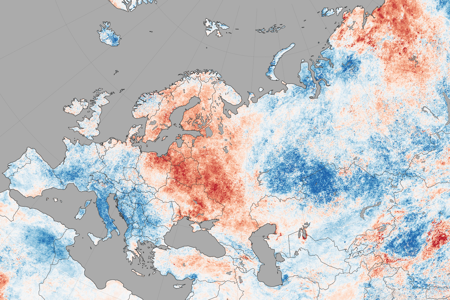
NASA reports that North America weather patterns for July 2014 were upside down:

If you live in the northern hemisphere, the past few weeks have been strange. In places where it should be seasonably hot—the eastern and southern United States and western Europe—it’s just been warm. In places where weather is usually mild in the summer—northern Europe, the Pacific coast of North America—it has been ridiculously hot.

Records for high temperatures (mid-30s°C, mid-90s°F) were approached or broken in Latvia, Poland, Belarus, Estonia, Lithuania, and Sweden in late July and early August. Searing temperatures also dried out forests and fueled wildfires in Siberia; in the U.S. states of Oregon, Washington, and California; in the Canadian provinces of British Columbia, Alberta, and Northwest Territories; and even in Sweden. At the same time, cool air moved from high northern latitudes into much of the U.S., setting record-low daytime and nighttime temperatures as far south as Florida and Georgia. Temperatures dropped to the winter-like levels in the mountains of Tennessee.

The maps on this page shows land surface temperature (LST) anomalies for July 27–August 3, 2014. They were built from data collected by the Moderate Resolution Imaging Spectroradiometer (MODIS) on NASA’s Aqua satellite, and the 2014 data is compared to the average for the same week as observed from 2005–2013. You can visit NASA Earth Observations for a view of temperature anomalies for the entire month of July.

Unusual July Temperatures

Color bar for Unusual July Temperatures

Observed by satellites uniformly across the entire globe, land surface temperatures are a measure of the amount of infrared energy (thermal radiance) emitted by Earth’s surface as it is heated by daylight and cooled in the dark of night. LSTs are sometimes referred to as land “skin” temperatures, and indeed they are a reflection of how hot a surface would feel to the touch. LST anomalies, as shown on this page, are not absolute temperatures; instead, they show how much temperatures were above or below the average. The darkest reds show areas that were as much as 10°C (20°F) above the norm; blues show areas that were below normal; light gray depicts areas with incomplete data (often due to cloud cover, such as in the area of the Indian monsoon); dark gray is ocean.

Meteorologists saw several possible and related causes for the heat waves and cooling patterns. High pressure systems over Scandinavia and northern Russia, as well as over the Pacific Northwest of North America, allowed stable air masses to build up heat domes and “block” incoming fronts that could bring changes in winds, precipitation, and temperatures. These blocking patterns worked together with unusual bends and meanders in the jet stream, which took on a see-sawing north-south pattern over the northern hemisphere. The jet moved air northward over the Pacific Ocean and warmed northwest Canada and the west coast of the U.S.; it dove south from cooler areas of Canada into the central and eastern U.S.; and it drove warm Atlantic air north into northern Europe. The jet took a similar north-south zig-zag in western and eastern Siberia. This pattern is more common in winter than in summer.

bookmark_borderClimate Disruption

The United States of America released a report on global warming and has named the problem climate disruption.


The report +confirms that climate change is not a distant threat — it’s affecting us now.” Climate disruption is “expected to become increasingly disruptive across the nation throughout this century and beyond,” the National Climate Assessment concluded.

“President Obama has announced a series of executive actions to reduce carbon pollution, prepare the U.S. for the impacts of climate change, and lead international efforts to address global climate change.”

Due to climate change, the weather is getting more extreme Temperatures are rising across the U.S. Temperatures from 2001 to 2012 were warmer than any previous decade in every region of the United States. Explore this interactive map from the National Climate Assessment to learn more.

EXTREME WEATHER EVENTS
Droughts, Wildfires, and Floods are all more frequent and intense. Precipitation was 2.57 inches below the 20th Century Average. Wildfires burned more than 9.3 million U.S. acres.

Extreme weather comes at a cost

Climate and weather disasters in 2012 alone cost the American economy more than $100 billion

$30 Billion U.S. drought/heatwave

$65 Billion Superstorm Sandy

$11.1 Billion Combined severe weather

$1 Billion Western wildfires

$2.3 Billion Hurricane Isaac

There are also public health threats associated with extreme weather

Children, the elderly, and the poor are most vulnerable to a range of climate-related health effects, including those related to heat stress, air pollution, extreme weather events, and diseases carried by food, water, and insects.


We can choose to believe that Superstorm Sandy, and the most severe drought in decades, and the worst wildfires some states have ever seen were all just a freak coincidence. Or we can choose to believe in the overwhelming judgement of science — and act before it’s too late.
– President Obama

bookmark_borderRecord-Setting Rain

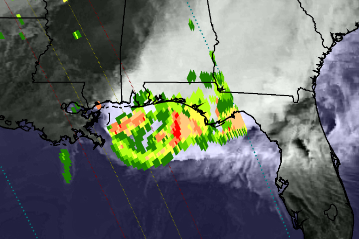
On April 29, 2014, the Global Precipitation Measurement (GPM) satellite observed the heavy rain that produced floods near Pensacola, Florida. The National Weather Service reported record-setting rainfall totals of more than 380 mm (15 inches) in Pensacola from the storm system that inundated the southeastern and eastern United States in recent days.

This image shows GPM Microwave Imager (GMI) rainfall estimates (green to red) superimposed on infrared observations (showing clouds and land) over the southeastern United States. Because the GPM satellite was launched only two months ago, the rainfall-estimation algorithms are currently undergoing a checkout period. For this reason, the scale indicates only qualitative information with green for light rain and red for heavy rain.

This GPM data was collected during a single satellite overpass shortly after noon local time, providing a snapshot of rain rates at that time. The outer blue dotted lines show the width of observations from the GMI instrument, while the two inner lines represent the area measured by the Ka-band (inner lines) and Ku-band (outer lines) of the Dual-Frequency Precipitation Radar. Once the radar data become available, they will provide a three-dimensional view of rain, ice, and snow in the atmosphere.

Extreme Weather
Extreme Weather

bookmark_borderWashington Mudslide

You would think with all the mud slinging in Washington DC that would be the Washington with the mudslide. No, the mudslide that killed over a dozen people and left over 100 missing was in Oso, Washington. Oso is a small village 55 miles northeast of Seattle (or, perhaps we should say *was*.) The village was “obliterated” after weeks of heavy rain.

This sort of extreme weather event is expected to become more normal due to the effects of global warming.