bookmark_borderBark Beetles Killing Sequoias

The Guardian Reports: Beetles and fire kill dozens of ‘indestructible’ giant sequoia trees

Deadly interaction between insects, drought and fire damage have forced California’s park officials to trigger climate crisis plans intended for the 2050s

‘This is not how sequoias die. It’s supposed to stand for another 500 years’

Giant sequoia trees, the largest living organisms on the planet – some more than three millennia old – have started dying from beetle attacks linked to the climate emergency, the preliminary findings of a new study have revealed.

The deaths of the trees, some of which lived through the rise and fall of hundreds of empires, caliphates and kingdoms – not to mention the inauguration of every US president – have shocked researchers in their speed and novelty.

In Sequoia and Kings Canyon national parks in the Sierra Nevada, California, 28 giant sequoias have died from a seemingly deadly interaction between bark beetles, drought and fire damage since 2014, according to a joint National Park Service and US Geological Survey study that will be published later this year.

bookmark_borderExtreme Weather Events Getting More Extreme

The U.N. has released a report entitled, “Extreme Weather Continues in 2018 – a Continuing Call to Climate Action”.

Addressing the dangers associated with extreme weather conditions, the Executive Secretary of the UN Climate Change Patricia Espinosa said: “We must keep an eye on the future. As the superstorms and monsoon flooding of last year and the extreme heat and extreme cold of this year show – we still have a long way to go to deliver on the promise of the Paris Climate Change Agreement”.

This year, record warmth was observed across parts of North America, Europe and Asia, as well as the Atlantic, Pacific and Indian Oceans. Record cold May temperatures were limited to northeastern Canada and the northern Atlantic Ocean, off the southern coast of Greenland.

The study published in the journal Nature showed that ice losses from Antarctica are causing sea levels to rise faster today than at any time in the past 25 years. Results of the Ice Sheet Mass Balance Inter-Comparison Exercise (IMBIE).

According to NASA, “Antarctica’s potential contribution to global sea level rise from its land-held ice is almost 7.5 times greater than all other sources of land-held ice in the world combined. The continent stores enough frozen water to raise global sea levels by 190 feet (58 meters), if it were to melt entirely. Knowing how much ice it’s losing is key to understanding the impacts of climate change now and its pace in the future.”

NOAA points to climate change as part of the problem causing the largest wildfires in California.

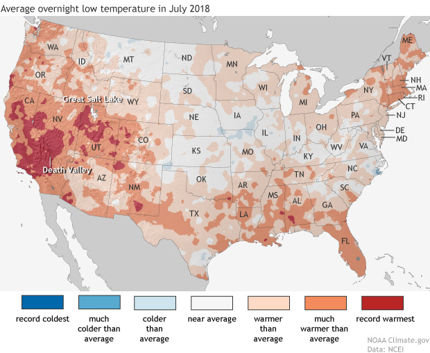
Daytime high temperatures were well above average across much of the western United States in July, but it was overnight low temperatures that were really extreme in large areas of California—where firefighters are battling multiple wildfires—and the Great Basin, and in isolated pockets of Colorado and the Southwest.

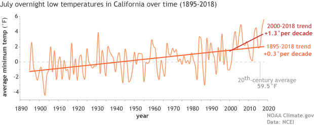
Map of the contiguous United States showing July 2018 overnight low temperature ranksAs the NCEI’s Deke Arndt has blogged about before, nighttime low temperatures are increasing faster than daytime high temperatures across most of the contiguous United States. For much of the West and Southwest, July’s record-breaking nighttime heat is a new highpoint in a long-term trend—one that has rapidly accelerated in recent decades. In California, average overnight low temperature in July rose by 0.3°F per decade over the historical record (1895-2018), but since 2000, the pace of warming has accelerated to 1.3°F per decade.

graph of July minimum temperature 1895–2018 with long-term trend and trend since 2000 shown

Average July minimum temperatures (overnight lows) in California  (light orange line) from 1895–2018. The trend over the historical record is shown in dark orange, and the recent trend (2000-2018) is shown in red. The twentieth-century average is shown with a gray line. NOAA Climate.gov graph, based on data from NCEI’s Climate at a Glance.

According to Tim Brown, director of NOAA’s Western Region Climate Center (WRCC), it’s a pattern that has serious consequences for wildfires and those who combat them. When temperatures cool off overnight, it’s not just a physical relief for firefighters who may be working in conditions that push the limits of human endurance; fire behavior itself relaxes as temperatures drop, winds grow calmer, and relative humidity rises. He explained via email,

Moisture in dead vegetation continuously tries to reach equilibrium with atmospheric moisture. So if nighttime temperature is staying warmer, then the humidity is lower, and the fuels stay drier. A dead fuel moisture reduction of a few percent can increase flammability, flame length, and subsequent overall fire behavior.

When fires remain active at night, it can increase both the time to containment and total burned area, while also affecting public health and safety through more smoke production and lower air quality.  Brown says that qualitatively, there seems to be an increase in firefighters’ reports of active nighttime fire behavior since around 2000.  He and other researchers are currently investigating whether that relationship can be confirmed quantitatively.

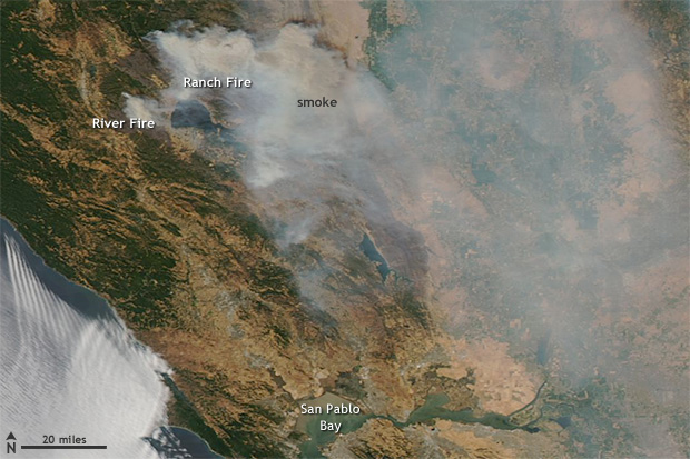
satellite image of fires and smoke near Clear Lake, California on August 6, 2018

NASA Aqua satellite image of the Ranch and River Fires in Northern California on August 6, 2018, with a pall of smoke spreading to the east.  These fires are part of the Mendocino Complex  Fire, which has become the largest fire in California history.  Extreme fire activity in the state was exacerbated by record-warm overnight low temperatures in July. Image from NASA Worldview website.

Nighttime warming has consequences for other aspects of public health. WRCC climatologist Nina Oakley pointed out via email that the South Coast region of California is experiencing the largest warming trends in nighttime temperatures, according to an environmental health hazard report from the California Environmental Protection Agency. In many communities in the region, air conditioning—rarely needed in the past—is uncommon. In addition, since 2000, heat waves in California have become more humid. In the report, experts offered a warning about the change:

People, animals, and plants that are adapted to California’s traditionally dry daytime heat and nighttime cooling are unable to recover from extreme heat, especially when humidity is high at night. The increase in nighttime heat waves presents an additional risk factor for vulnerable populations.

The rapid increase in the rate of warming in California and other parts of the U.S. West since the start of the new century is a sharp reminder that we can’t necessarily count on the future changing as slowly as the past. Asked about the July nighttime heat in California, California state climatologist Mike Anderson answered via email, “As for the past decade or two, we have noticed observations have looked different than the rest of the historical record. We are consistently sampling at the warm edge of the historical distribution now, and expectations are for that to continue, with new records being set with increasing frequency in the coming years.”

Parts of Pennsylvania recorded record rainfall during the summer of 2018 with frequent “tropical downpours” delivering thirteen or more inches of rain in a 5 day period. The Penn Environment Organization released a report entitled, “Hitting Close to Home | Global Warming is Fueling Extreme Weather Across the U.S.”

Weather-related disasters affect millions

  • Since September 2010, counties housing 84 percent of the total Pennsylvania population (over 10 million residents) were affected by federally-declared weather disasters.
  • Pennsylvania experienced five weather-related disasters, including severe storms, tornadoes, floods, and tropical storms since September 2010.

Extreme weather causes widespread destruction

  • In February 2015 a large winter storm and associated cold wave impacted many central, eastern and northeastern states, including Pennsylvania. The storm and cold wave caused at least 30 deaths and the total estimated costs were over $1 billion in the affected region.
  • In October 2012 Hurricane Sandy caused extensive damage to several states, including Pennsylvania from wind, rain, and heavy snow. Hurricane Sandy caused at least 159 deaths and the total estimated costs were $67.6 billion in the affected regions.
  • Since 2010, extreme weather events have caused at least 30 power outages in Pennsylvania, including one outage that lasted 10 days in 2012 during Hurricane Sandy. [3]


Weather extremes are becoming more common 

Globally, 2015 was Earth’s hottest year on record, surpassing 2014. [4] Many types of extreme weather are expected to become more frequent or severe in a warming world, which could lead to more weather-related disasters.

  • Tropical Storms and Hurricanes: Global warming has the potential to make tropical storms more destructive. Hurricanes and other coastal storms are likely to be more powerful [5] and rainier, [6] while storm surges could be more destructive as sea levels rise. [7]
  • Heavy Rain and Snow: Extreme precipitation is already increasing; continued trends could increase the risk of intense downpours, heavy snowstorms and severe flooding. [8]
  • Droughts and Wildfires: While global warming is anticipated to bring more rain to some areas, it will also likely elevate temperatures and extend dry spells. The potential for stronger drought—and greater area burned by wildfires—will increase, particularly in the West and Southwest.

Every year the World Economic Forum publishes the Global Risks Report. This year’s report suggests that experts anticipate another year of heightened risk. From the approximately 1000 respondents of the annual Global Risks Perception Survey, 59% expect an intensified risk, compared to 7% pointing to declining risks.

Environmental risks have grown in prominence over the 13-year history of the Global Risks Report. This trend continues in the 2018 report. All five risks in the environmental category are ranked higher than average in both likelihood and impact over a 10-year horizon.

“Extreme weather events” and “Natural disasters” rank among the top three risks in terms of likelihood and impact. “Failure of climate-change mitigation and adaptation” ranks among the top five.


The Human Induced Climate Change Experiment (Global Warming Research and Educational Materials)

bookmark_borderClimate Disasters Made for Costliest Year

The National Oceanic and Atmospheric Administration (NOAA) reports:
2017 will be remembered as a year of extremes for the U.S. as floods, tornadoes, hurricanes, drought, fires and freezes claimed hundreds of lives and visited economic hardship upon the nation. Recovery from the ravages of three major Atlantic hurricanes making landfall in the U.S. and an extreme and ongoing wildfire season in the West is expected to continue well into the new year

Billion-dollar disasters in 2017

Last year, the U.S. experienced 16 weather and climate disasters each with losses exceeding $1 billion, totaling approximately $306 billion — a new U.S. record.

Far more tragic was the human toll. At least 362 people died and many more were injured during the course of the disasters that included:

1 freeze;
1 drought (affected multiple areas);
1 wildfire (affected multiple areas);
2 floods;
3 major hurricanes (Harvey, Irma and Maria); and
8 severe storms.

The biggest newsmakers include the western U.S. wildfires that caused damages tallying $18 billion — triple the previous U.S. record. Losses from Hurricane Harvey exceeded $125 billion, which ranked second only to Hurricane Katrina, the costliest storm in the 38-year period of record. Hurricanes Maria and Irma had total damages of $90 billion and $50 billion, respectively. Hurricane Maria now ranks as third costliest weather and climate disaster on record for the nation, with Irma coming in close behind as fifth costliest.

Since 1980, the U.S. has sustained 219 weather and climate disasters that have exceeded $1.5 trillion in overall damages to date.

Billion Dollar Disasters

16 weather and climate disasters each with losses exceeding $1 billion

During 2017, the U.S. experienced a historic year of weather and climate disasters. In total, the U.S. was impacted by 16 separate billion-dollar disaster events tying 2011 for the record number of billion-dollar disasters for an entire calendar year. In fact, 2017 arguably has more events than 2011 given that our analysis traditionally counts all U.S. billion-dollar wildfires, as regional-scale, seasonal events, not as multiple isolated events.

More notable than the high frequency of these events is the cumulative cost, which exceeds $300 billion in 2017 — a new U.S. annual record. The cumulative damage of these 16 U.S. events during 2017 is $306.2 billion, which shatters the previous U.S. annual record cost of $214.8 billion (CPI-adjusted), established in 2005 due to the impacts of Hurricanes Dennis, Katrina, Rita and Wilma.

bookmark_borderSave the Monkey Puzzle Tree

Wildfires in Chile are threatening the Monkey Puzzle trees (Araucaria araucana) some of which are over a thousand years old. Chile has been in an 8 year drought that is largely blamed on global warming.

“Faced with this critical situation, there is no choice but to assume that the lack of water resources is a reality that is here to stay and that puts at risk the development of important regions of our country” President Bachelet said.

The BBC reports, “Scientists in Chile say they are expecting rainfall to drop significantly by 2050 as the country is increasingly affected by climate change. ”

bookmark_borderYosemite Wildfire

One of the largest wildfires to ever hit California caused a smoke plume effecting air quality over 100 miles away. The fire has already destroyed over 110 structures and continues to burn out-of-control.

““It was like a bomb went off, exploded,” a firefighter said. “When the inversion lifted, the fog coming from the smoke, when it lifted, this fire exploded and it’s been running away ever since.”

So far, more than 288-square-miles have burned.

The park has issued this statement:
Most of Yosemite National Park is not affected by the fire and is relatively smoke-free. The northern part of the park, including some areas along the Tioga Road, has some smoke. Conditions may change if winds shift. However:

* The Big Oak Flat Road (the continuation of Highway 120 inside Yosemite) and Highway 120 west of Yosemite are closed between J132 near Buck Meadows (outside the park) to Crane Flat (inside the park). Beginning at noon on Wednesday, August 28, the only access to Yosemite Valley is via Highway 140 from Merced or Highway 41 from Fresno.
* Beginning at noon on Wednesday, August 28, the Tioga Road (Highway 120 through the park) is closed from Crane Flat to Yosemite Creek. The only access to the Tuolumne Meadows area is via Highway 120 from near Lee Vining.
* Hetch Hetchy Road and Evergreen Road are closed.
* White Wolf is closed, including the lodge, campground, road, and trails originating from White Wolf.
* Crane Flat, Hodgdon Meadow, Tamarack Flat, Yosemite Creek, and White Wolf Campgrounds and Hetch Hetchy Backpackers’ Campground are closed.
* Merced and Tuolumne Groves of Giant Sequoias are closed so firefighters can work on preventive fire suppression efforts. The groves are not currently in imminent danger.
* Wilderness trail closures: The area west of the May Lake Road and May Lake Trail continuing to the junction with the Pacific Crest Trail (PCT) at Glen Aulin and then north along the PCT to Bond Pass is closed. The park’s boundary serves as the closure’s northern and western edge extending south to the junction of the Big Oak Flat Road and Tioga Road at Crane Flat. The closure’s boundary continues east from Crane Flat paralleling the Tioga Road a half mile to its south to the Tamarack Flat Campground Road. The closure follows the Tamarack Flat Campground Road to the campground then continues on the Tamarack Creek trail to the junction with the North Rim Trail. Then east along the North Rim trail to the Yosemite Creek trail north to the Tioga Road. The closure then follows the Tioga Road east to the May Lake Road. The trails serving as the eastern and southern boundary of the closed area remain open. May Lake High Sierra Camp, Glen Aulin High Sierra Camp, and Porcupine Flat Campground are open.

bookmark_borderArizona Wildfire

Extreme weather conditions in the Southwestern United States have resulted in several wildfires. Nineteen of the world’s best firefighters were killed in the Arizona wildfire.

The state of Arizona says: Yarnell Hill Fire Reported 45 Percent Contained
(Posted July 3, 2013, at 9:32 p.m.) The Yarnell Hill Fire burning southwest of Prescott, Ariz., is reported 45 percent contained.

Residents of Peeples Valley and Yarnell, evacuated by the Yavapai County Sheriff’s Office on Sunday, remain out of their homes. The Yarnell Fire Department and Yavapai County are assessing homes and structures around Glen Ilah and Yarnell.

Red Cross shelters are open at Yavapai Community College in Prescott at 928-717-8210 and at the Wickenburg High School in Wickenburg at 480-213-0706. People and small animals are welcome at both shelters while large livestock can be taken to Hidden Springs Ranch on Highway 89.

State Highway 89 remains closed between MP 270 and MP 238. The Yavapai County Sheriff’s Office has three different road blocks: the junctions of Highway 89 and Hays Ranch Road; Hays Ranch Road and Sickles Ranch Road; and at Buckhorn and Frontier Road.

Again, temperatures are expected to be in the low 90s, humidity 15-19 percent, and predicted winds out of the west at 4 to 6 miles per hour, gusting up to 12 miles per hour.

Locally, gusts up to 30 mph may occur near thunderstorms. The decreased relative humidity and increased wind speeds could cause more erratic fire behavior. No significant rain is expected in the next 7-10 days. However, overall fire behavior should continue to diminish due to fuels being consumed.

Tomorrow, firefighters will continue work on the eastern flank with a goal of connecting the contained areas on the northeast and southeast corners between Yarnell and Peeples Valley.

On the northern portion, hot shot crews will continue to build line towards a ridge above Peeples Valley. Scouting will take place along the western flank and contingency plans will continue to be refined in case the fire becomes active again. Firefighters will also support initial attack in the area as needed.

Creeping and smoldering are expected to continue around the structures, though sometimes not showing until the afternoon, and some areas around structures are still holding enough heat to be a concern. A plan is being developed to restore utilities and infrastructure to the affected communities.

Yarnell Hill Fire facts:
Fire Start Date: June 28, 2013 at 5:30 p.m.
Location: West of State 89 between Yarnell and Peeples Valley
Size: Estimated at 8,400 acres
Containment: 45 percent
Cause: Lightning
Personnel: 681 (includes 15 crews and 26 engines)
Aircraft: Thirteen helicopters are assigned to the incident and air tankers are available to support firefighters.

bookmark_borderColorado Wildfires

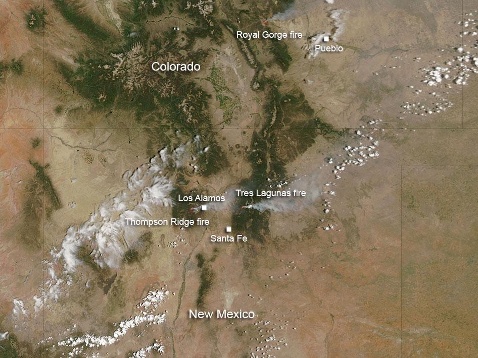
Over 500 homes have been destroyed in the Colorado wildfires. According to NASA: The Royal Gorge fire in Colorado was first reported at 1 p.m. Tuesday June 11, south of the Royal Gorge Bridge and Arkansas River. It is estimated at 3800 acres. At present the Arkansas River has been closed from Spike Buck through Canon City. The Royal Gorge Bridge and Park has been evacuated.

Resources on scene include: 150 firefighters and Law Enforcement officers from both federal and local departments. Resources ordered include: 2-Single Engine Airtanker and 1 Heavy Air Tanker.

The cause of the fire is under investigation.

The New Mexico fires include Thompson Ridge and Tres Lagunas fires. There is another fire in New Mexico south of the area where these fires are located, and that fire is known as the Silver fire. It is not visible in this image, although in the larger image that is included, it is visible.

The Thompson Ridge fire started on May 31, 2013. The cause was human in nature. It is located on the Valles Caldera National Preserve about two miles northeast of La Cueva, New Mexico. The fire is in steep rugged terrain and is burning mixed conifer and ponderosa pine. It has currently burned over 21,000 acres and is 50% contained. However, the growth potential for this fire is high due to rugged terrain, low humidity and dry conditions. Total personnel working this fire is 991.

The Tres Lagunas fire which started on May 30, 2013 was caused by human error and a downed power line. Currently it has burned over 10,000 acres. This fire is 10 miles north of Pecos, New Mexico.

There is a red flag warning for the area today which heralds hot, dry conditions with temperatures remaining well above normal. Stronger and gustier west/southwest winds are expected today with low humidity. All these conditions can contribute to fire growth. At this time the fire is 77% contained.

At present 14 Hand Crews, 5 Helicopters, 17 engines, 2 bulldozers, and 4 water tenders are fighting this fire.

This natural-color satellite image was collected by the Moderate Resolution Imaging Spectroradiometer (MODIS) on June 11, 2013. Actively burning areas, detected by MODIS’s thermal bands, are outlined in red.

NASA image courtesy Jeff Schmaltz, MODIS Rapid Response Team. Caption: NASA/Goddard, Lynn Jenner

colorado-wildfires-2013

bookmark_borderMore Fire, Less Snow

If a tree falls in a forest and no one is around to hear it, does it make a sound?

The answer is yes, if it happened in New Mexico’s Jemez River Basin on June 26, 2011, at 1 p.m. local time.

The tipping of one tree as it creaked and fell hinted at a crackle soon to come, a fast-burning wildfire. Ultimately, the fire blazed through a large part of a 1.5 million-acre national forest.

On the day the fire started, strong, unpredictable winds blew through the trees, rustling leaves and creaking dead wood. Perhaps in a gust, a lone tree fell. On the way down, it took out a power line and sparked a fire that–by high noon the next day–had burned 43,000 acres, an acre every two seconds.

At sundown that next day, the Las Conchas Fire, as it came to be called, still ran wild. The toll had climbed to more than 61,000 acres of forest. Egged on by north winds, it jumped the trails of Pajarito Mountain Ski Area. Then it turned and raged south, threatening the town of Cochiti, N.M.

Within four days, it had singed more than 103,000 acres, making it the largest fire in New Mexico history at the time.

The forest and the watershed–the critical zone–left behind

What happened to the forests, rivers and streams the Las Conchas Fire left behind?

To find out, scientists at the National Science Foundation (NSF) Jemez River Basin and Santa Catalina Mountains Critical Zone Observatory (CZO), one of six such NSF CZOs in watersheds across the country, lit out for the hills.

The Jemez River Basin and Santa Catalina Mountains CZO is formed by twin sites: one in the Jemez River Basin in the Valles Caldera National Preserve north of Albuquerque, N.M., in the greater Rio Grande Basin; the other in the Santa Catalina Mountains northeast of Tucson, Ariz., in the Colorado River Basin.

In addition to the Jemez River Basin and Santa Catalina Mountains site in New Mexico and Arizona, NSF CZOs are located in the Southern Sierra Nevada, Christina River Basin on the border of Delaware and Pennsylvania, Susquehanna Shale Hills in Pennsylvania, Boulder Creek in the Colorado Rockies, and Luquillo National Forest in Puerto Rico.

CZO scientists provide a new understanding of the critical zone–the thin veneer of Earth that extends from the top of the forest canopy to the base of weathered bedrock.

At the Jemez River and Santa Catalina Mountains CZO, researchers are asking questions such as: How does climate variation affect arid and semi-arid ecosystems? And, how do feedbacks between critical zone structure and the cycling of water and carbon alter short-term hydrology and long-term landscape evolution?

The water cycle, the breakdown of rocks and the eventual formation of soil, the evolution of rivers and valleys, the patterns of plant growth and landforms, all result from processes that take place in the critical zone.

“The critical zone is our living environment,” says Enriqueta Barrera, program director in NSF’s Division of Earth Sciences, which funds the CZO network. “The CZOs offer us new knowledge about this important zone and its response to climate and land-use change.”

The CZOs are the first systems-based observatories dedicated to understanding how Earth’s surface processes are coupled, she says. “They will help us predict how the critical zone affects the ecosystem services on which society depends.”

Fire burns long after it’s out

Water is at the top of that list of ecosystem services.

The freshwater supplies of the American West rely, for the most part, on snow.

As snow melts into water, it begins a journey that starts in the mountains and ends in faucets. When people turn on the shower or the sprinkler, they’re watering themselves, lawns and food crops with melted snow.

The Colorado River, the Rio Grande and other rivers in the intermountain west are the main sources of water for some of the driest parts of the country, say Jemez River Basin and Santa Catalina Mountains CZO scientists Jon Chorover and Paul Brooks of the University of Arizona and Adrian Harpold of the University of Colorado.

“Their flows are predominantly fed by snowmelt from high-elevation forests and meadows,” says Brooks.

Snow-covered forests are “a critical source of water in the western U.S.,” agrees Chorover. “Forests’ ability to ‘hold snow’ can be affected by fires, tree diseases, insect-caused die-offs and other factors.”

The Las Conchas Fire provided a unique opportunity to “evaluate how forest fires interact with a changing climate,” says Harpold, first author of a recent paper on the fire’s effects on winter snow and spring snowmelt published in the journal Ecohydrology. Brooks and other scientists are co-authors.

“Forest fires have been increasing in size and severity for the last several decades,” Harpold says. “Drier and warmer than average conditions in New Mexico in 2011 contributed to fires like Las Conchas.

“When the fire removed the forest canopy, more water vapor was lost from the snow surface to the dry atmosphere, reducing the amount of water stored in the snowpack and released the following spring.”

In essence, the scientists found, areas not burned in the fire retained more snow–and snowmelt water.

Into the Valles Caldera

The Valles Caldera National Preserve, it’s called, a parkland that surrounds the Valles Caldera, a 13.7 mile wide volcanic caldera in the Jemez Mountains of northern New Mexico. The preserve overlaps the Jemez River Basin CZO.

Valles Caldera National Preserve was the site of the scientists’ study; their research was conducted on Rabbit Mountain near the park’s southern boundary.

In November 2011, the researchers placed instruments in several catchments, or river basins, on Rabbit Mountain. The resulting information is being used to better understand the effects of fire on the water, carbon and energy cycles of the entire Jemez River Basin.

“The Jemez River Basin CZO is perfectly situated to learning how fire affects water resources,” says Brooks.

In the winter and spring of 2012, Brooks and Harpold, along with other researchers and students, collected and analyzed thousands of data points on snow depth and density in burned and unburned forests on Rabbit Mountain.

“We obtained one of the most complete data sets to date on snow hydrology and fire,” says Brooks.

Spruce-fir forests dominate Rabbit Mountain’s heights; ponderosa pines and oak scrublands cover the lower mountain.

Whether in spruce-fir or pine-oak, the Las Conchas Fire left much of Rabbit Mountain with severe burns. Dead, limbless trees, ghosts of the forest, line the horizon.

In unburned forests, about one-third of the fresh snow that fell in the winter of 2012 was caught in trees before it reached the ground. There shade and wind protection allowed it to accumulate over the winter.

Where trees were lost to the fire, more fresh snowfall made it to the ground. In the end, however, that was a double-edged sword: lack of shelter from the forest canopy resulted in more of the snowpack disappearing over the winter.

“Such changes in snowpack depth have important ramifications,” says Chorover, “for ecological health and for downstream water resources.”

After the Las Conchas Fire, if a tree falls in the forest and no one is around to hear it, does it make a sound?

If you’re listening for burbling spring brooks or streaming kitchen faucets, you may hear nothing but drip, drip, drip. Or silence.
— Cheryl Dybas, NSF (703) 292-7734 cdybas@nsf.gov
bookmark_borderHot. Hot. Hot.

Australia — Temperatures in Australia are reaching high heights with the current heat wave. Bush fires are burning wild. Tomorrow, the  temperature is forecast as a high of 50 degrees… 50 centigrade… that’s 122 Fahrenheit.

bookmark_borderActs Of God

Natural Disasters in August, 2012

Tropical Storm IsaacAugust 29, 2012
Tropical Storm Isaac
 Hurricane IsaacAugust 28, 2012
Hurricane Isaac
Trinity Ridge FireAugust 28, 2012
Trinity Ridge Fire
Tropical Storm BolavenAugust 28, 2012
Tropical Storm Bolaven
Tropical Storm IsaacAugust 28, 2012
Tropical Storm Isaac
Wildfires in SiberiaAugust 28, 2012
Wildfires in Siberia
Tropical Storm IsaacAugust 27, 2012
Tropical Storm Isaac
Typhoon BolavenAugust 26, 2012
Typhoon Bolaven
Wildfires in AlgeriaAugust 25, 2012
Wildfires in Algeria
Typhoon BolavenAugust 24, 2012
Typhoon Bolaven
Tropical Storm IsaacAugust 23, 2012
Tropical Storm Isaac
Wildfires in CaliforniaAugust 23, 2012
Wildfires in California
Typhoon TembinAugust 20, 2012
Typhoon Tembin
Wildfires in CaliforniaAugust 19, 2012
Wildfires in California
 Wildfire on ChiosAugust 18, 2012
Wildfire on Chios
Typhoon Kai-takAugust 17, 2012
Typhoon Kai-tak
Typhoon Kai-takAugust 16, 2012
Typhoon Kai-tak
Plume from Batu TaraAugust 15, 2012
Plume from Batu Tara
Thick Smoke over WyomingAugust 14, 2012
Thick Smoke over Wyoming
Wildfires in IdahoAugust 14, 2012
Wildfires in Idaho
Tropical Storm Kai-takAugust 13, 2012
Tropical Storm Kai-tak
Western WildfiresAugust 13, 2012
Western Wildfires
Tropical Storm ErnestoAugust 8, 2012
Tropical Storm Ernesto
2012 Arctic CycloneAugust 7, 2012
2012 Arctic Cyclone
Hurricane ErnestoAugust 7, 2012
Hurricane Ernesto
 Mount Tongariro EruptsAugust 7, 2012
Mount Tongariro Erupts
Typhoon HaikuiAugust 7, 2012
Typhoon Haikui
Tropical Storm ErnestoAugust 6, 2012
Tropical Storm Ernesto
Typhoon HaikuiAugust 6, 2012
Typhoon Haikui
Halstead Fire, IdahoAugust 3, 2012
Halstead Fire, Idaho
 Typhoons Saola and DamreyAugust 1, 2012
Typhoons Saola and Damrey