bookmark_borderCollapse of the Amazon

September 28. 2023

1) much of July was spent at record temperatures +3C
2) the collapse of the Amazon rainforest is likely to happen at +2-4C. The collapse of the Amazon is expected to occur because of changing weather patterns and circulation that result in drought.
3) Today Brazil set up a task force for “unprecedented drought in the Amazon” [A DROUGHT IN THE RAINFOREST]

Low river levels and hotter waters have killed masses of fish seen floating on river surfaces, contaminating the drinking water, Environment Minister Marina Silva said.

“We have a very worrying situation. This record drought has disrupted river transport routes (dropping 30 cm / day) threatening food and water shortages, and a large fish mortality is already beginning,” she told Reuters in an interview.

Silva said this was the effect of a periodic El Niño mixing with changes in weather patterns brought by global warming.

“We are seeing a collision of two phenomena, one natural which is El Niño and the other a phenomenon produced by humans, which is the change in the Earth’s temperature,” she said.

Worsened by climate change, this combination has caused drought not seen before in the Amazon and “is incomparably stronger and could happen more frequently,” she added.

Scientists concur that a rise of 2 degrees will trigger feedback loops and tipping points. Triggering these tipping points results in the CO2 stored in nature to be released. Though we do not know how much carbon is stored in nature, it would be reasonable to assume that the temperature could be pushed from 3 degrees to 6 degrees above pre-industrial levels. Humans cannot thrive above a rise of 1.5 degrees. Humans cannot survive if the temperature rises 6 degrees.

Climate Change Tipping Points

Climate Change: Rate of Acceleration: By 2020, there was enough data to see the “doubling period” of some anthropogenic climate affects had gone from 100 years to 10 years.

What you can do today. How to save the planet.
Climate Change: How Long Is “Ever”?
Climate Change: The End of Times

The Human Induced Climate Change Experiment

bookmark_borderInsurance, and the Lack Thereof

The Washington Post reported, “Home insurers cut natural disasters from policies as climate risks grow“.

“Allstate, American Family, Nationwide, Erie Insurance Group and Berkshire Hathaway — have told regulators that extreme weather patterns caused by climate change have led them to stop writing coverages in some regions, exclude protections from various weather events and raise monthly premiums and deductibles.”

“they will cut out damage caused by hurricanes, wind and hail from policies underwriting property along coastlines and in wildfire country”

“places once considered safe from natural catastrophes could lose crucial insurance protections while their natural disaster exposure expands or intensifies ”

“Allstate said its climate risk mitigation strategy would include “limiting new [auto and property] business … in areas most exposed to hurricanes” and “implementing tropical cyclone and/or wind/hail deductibles or exclusions where appropriate.””

“Nationwide said it no longer underwrites coverage for “properties within a certain distance to the coastline” because of hurricane potential.”

“There’s no place to hide from these severe natural disasters”

“a policy in a region afflicted by hurricanes may exclude coverage for wind or hail damage, or in wildfire country, a policy without fire and smoke protection.”

“Activity has been observed in recent years that has differed from historical norms or modeled expectations.”

More articles on Flood Insurance, Rising Sea Levels and Global Warming.

bookmark_borderHealth Impacts of Air Pollution

By Daniel Brouse
June 30, 2023

The health impacts of air pollution are both cumulative and irreversible. The more polluted the air, the more severe the effects. The more polluted air you breathe over time, the more severe the effects. That is to say breathing “Moderate” quality air for 3 days might be similar to breathing “Unhealthy for Sensitive Group” quality air for 1 day. In both cases, your respiratory, circulatory, neurological, and immune systems have been damaged. A partial list of ailments include:
Alzheimer’s Disease, asthma, bronchitis, cancer, cataracts, chronic obstructive pulmonary disease (COPD), dementia, developmental damage, emphysema, gastrointestinal disorders, heart ailments, heart attacks, immune system dysfunction (including susceptibility to infections), ischaemic heart disease, impaired brain development in children, kidney disease, liver disease, lung disease, premature death, pneumonia, nasal and upper respiratory tract health problems, neurological disorders, respiratory system failure, skin diseases, strokes

You can (and should) check your local air quality several times a day at AirNow.gov. The air quality index (AQI) goes from 0 to 500. An AQI value of 50 or below represents good air quality, while an AQI value over 300 represents hazardous air quality.

EPA establishes an AQI for five major air pollutants regulated by the Clean Air Act. Each of these pollutants has a national air quality standard set by EPA to protect public health:

  • ground-level ozone
  • particle pollution (also known as particulate matter, including PM2.5 and PM10)
  • carbon monoxide
  • sulfur dioxide
  • nitrogen dioxide

Following is an explanation of two of these pollutants — particle pollution and ground-level ozone.

Particulate Matter (PM)

The EPA defines particulate matter (also called particle pollution): the term for a mixture of solid particles and liquid droplets found in the air. Some particles, such as dust, dirt, soot, or smoke, are large or dark enough to be seen with the naked eye. Others are so small they can only be detected using an electron microscope.

Particle pollution is similar to smoking cigarettes. The more you inhale, the worse it is for you. Also, the more particles in the air you breath, the worse it is for you. Breathing air on a day with an AQI that is unhealthy is similar to smoking a half-pack of cigarettes. If you go running instead of walking, it might be equivalent to smoking 2 packs of cigarettes.

The more particulate matter you breathe in over time, the greater the cumulative effect. The impact on your health will depend on your predisposition. In all cases your risk increases for nasal and upper respiratory tract health problems, heart attacks, strokes, asthma, and bronchitis, as well as premature death from heart ailments, lung disease, and cancer. Studies show that exposure can impair brain development in children and are significantly associated with the development of dementia and Alzheimer’s disease.

Some of the impacts of particle pollution may be reversed overtime if further exposure to particle pollution is eliminated. After five years of quitting smoking, the risk of developing complications decreases by up to 50%.

The best lifestyle is to avoid particulate matter. Exercise outside only on days with a “Good” AQI under 50. If you must go out on days with an AQI over 50, wear an N95 mask. Indoors build and run a Corsi-Rosenthal Box filter.

Ground-level Ozone

Tropospheric ozone is low level ozone caused by humans. Tropospheric ozone is “bad ozone” that causes health problems in humans, plants to die and other destructive results. (Stratospheric ozone, the good ozone, is the ozone layer in the stratosphere that keeps 95-99% of the suns ultraviolet radiation from striking the earth.)

“Tropospheric ozone is formed by the interaction of sunlight, particularly ultraviolet light, with hydrocarbons and nitrogen oxides, which are emitted by automobiles, gasoline vapors, fossil fuel power plants, refineries, and certain other industries.” — National Center for Atmospheric Research

Ozone primarily affects the respiratory and immune systems. The damage is permanent, untreatable and often results in death. The Santa Barbara County Air Pollution Control District reports, “Roughly one out of three people in the U.S. is at risk of experiencing ozone-related health effects.”

The best lifestyle is to avoid ozone exposure. Since heat and ultraviolet light are needed to create ozone, staying indoors offers the best protection. Neither masks nor air purifiers protect from ozone exposure. (Ozone is O3 and almost the same size as Oxygen O2)

REFERENCES
Death by Ozone
COVID-19 and Air Pollution
Ozone Know Zone
Air Pollution Kills
Indoor Air Pollution: How to Purify the Air, Aromatic Plants, and Phytoncides
Corsi-Rosenthal Box filter
The Human Induced Climate Change Experiment

bookmark_borderEurope Drought: And Yes, All Fish Will Die

Water wars… coming to a town near you:
* Europe hydrogeneration is down 20% in France, down 30% in Italy, and down 50% in Spain. And, did you know solar panels are less efficient in high temperatures? There is more resistance in all power lines, too.
* Germany the Rhine water levels fall to new low making it non-navigable for ships
* France is relocating fish into tanks because the water is too warm. Thousands of other fish die due to lack of O2 — “Without rain, the river “will continue to empty. And yes, all fish will die”

Politico reports, Watts going down? Europe’s scorching summer parches hydropower.
“Record-breaking temperatures are starving hydropower plants and raising questions about how to adapt them for the future.”

The Guardian reports, Europe’s rivers run dry as scientists warn drought could be worst in 500 years.
“Crops, power plants, barge traffic, industry and fish populations devastated by parched waterways”

The Human Induced Climate Change Experiment
bookmark_border2022 Climate Refugees in the USA

Climate change will eventually cause most American’s real estate to become worthless and uninhabitable.

“Currently, we have crossed the tipping point when human induced climate change triggers a chain reaction of feedback loops. The Earth will exceed 1.5 degrees Celsius (average global surface temperature over the surface of the earth for ten years) by the 2040’s and a societal collapse will ensue. For the most part, the Earth will be uninhabitable for humans by 2070 UNLESS immediate action is taken.” — Daniel Brouse and Sidd Mukherjee (climate scientists)

In an article entitled “A safer haven? How the Midwest can be a refuge amid climate change—if we prepare” the Detroit Business Journal reports:

In the early 21st century, global climate change is spawning a new kind of migrant to the Upper Midwest: “Climigrants” seeking refuge from the forest fires of Western states, flooding along the saltwater coasts and ever-rising temperatures causing drought in different corners of the continent.

The reason for their arrival here is as old as time: Humans reacting to a threatening change in the environment around them and seeking a more habitable place to live.

That’s because climate forecasts are grim. A new report from the National Oceanographic and Atmospheric Administration warns that the U.S. coastline will see up to a foot of sea level rise by 2050 due to climate change.

Many climigrants to the Great Lakes region would most likely come from eastern and southern coastal areas, from the drought-stricken Southwest and West, and from wildfire-vulnerable parts of California and the Pacific Northwest.

Some will leave ahead of disaster with enough resources to resettle comfortably.

Other climigrants may be devastated financially when their homes or businesses are destroyed and they lack flood or other insurance, raising social justice questions for the communities they might move to.

More on Climate Change Refugees

More on Climate Change

bookmark_borderExtreme Rainfall–surge Hazard Risks

by Daniel Brouse

Most climate change models forecast rising sea levels as the predominant threat of a warming climate to flood risks. Though sea level rise is of great concern, so should be extreme rainfall.

Both the sea and air temperatures are rising. Warm air can hold more moisture than cool air. Warmer sea temperatures result in more evaporation. Warmer air can hold more moisture. The increased moisture in the air moves over land causing inland deluges.

Hurricane Ida in the summer of 2021 is a good example. Because of the 85 degrees Fahrenheit Gulf of Mexico ocean temperature, Ida rapidly gained strength right before it made landfall jumping from a Category 1 to a Category 4 storm. The warm air allowed more moisture to be carried as rain. The storm was so large that it was able to pick up more moisture from the Atlantic Ocean. The ocean moisture was carried inland and dumped over places like Pennsylvania and New York. Ida caused record flood damage in parts of Pennsylvania. The Philadelphia Inquirer reported, “The remnants of Hurricane Ida destroyed or damaged hundreds of homes in Southeastern Pennsylvania and caused more than $100 million in public infrastructure damage across the state.” There were more deaths in the Northeastern USA than where the storm made landfall in Louisiana. The New York Times reported, “The remnants of Hurricane Ida caused flash flooding and a number of deaths and disrupted transit across parts of New York and New Jersey. The storm killed at least 43 people in New York, New Jersey, Pennsylvania and Connecticut and left more than 150,000 homes without power.”

The Journal Nature published the study Tropical cyclone climatology change greatly exacerbates US extreme rainfall–surge hazard examining how current models underestimate the risk of Rainfall–surge Hazard. “Tropical cyclones (TCs) are drivers of extreme rainfall and surge, but the current and future TC rainfall–surge joint hazard has not been well quantified. Using a physics-based approach to simulate TC rainfall and storm tides, we show drastic increases in the joint hazard from historical to projected future (SSP5–8.5) conditions. The frequency of joint extreme events (exceeding both hazards’ historical 100-year levels) may increase by 7–36-fold in the southern US and 30–195-fold in the Northeast by 2100. This increase in joint hazard is induced by sea-level rise and TC climatology change; the relative contribution of TC climatology change is higher than that of sea-level rise for 96% of the coast, largely due to rainfall increases. Increasing storm intensity and decreasing translation speed are the main TC change factors that cause higher rainfall and storm tides and up to 25% increase in their dependence.”

From the article Rising Temperatures Bringing Bigger Floods published in the Journal Science, “CO2 emissions have boosted risk of intense precipitation and consequent flooding. To determine how rising temperatures have altered flood risk, atmospheric scientist Pardeep Pall of the University of Oxford in the United Kingdom and his colleagues ran thousands of climate simulations. In roughly half of them, they reduced atmospheric concentrations of carbon dioxide to levels measured in the year 1900, and they adjusted ocean temperatures and the amount of Arctic sea ice—which affects high-latitude weather patterns—accordingly. In the other simulations, they modeled modern conditions. Then they compared the rainfall amounts generated in both types of simulations. Finally, they fed the rainfall values into a model that assesses the potential for flooding. In 90% of the simulations, results suggested that the flood risk in England and Wales in autumn 2000 was at least 20% higher than it would have been in 1900.”

As the Earth warms, the air will hold more moisture. More moisture-laden air moves over land and creates atmospheric rivers (Pineapple Express). The Journal EOS in the article Atmospheric Rivers Spur High-Tide Floods on U.S. West Coast said, “Atmospheric rivers are narrow bands of moisture that travel across the lower troposphere, generally at the leading edges of massive low-pressure systems. At their peak, they can carry as much water through the sky as the Amazon River does on land. They unleash intense winds and heavy rain as they surge across the Pacific Ocean, eventually making landfall on the U.S. West Coast, contributing to many high-tide flooding events.”

The atmospheric rivers also bring heavy rainfall inland causing extreme flooding. In October of 2021 NOAA said, “a convergence of storms brought more than half a foot of rain to parts of the Bay area in addition to strong winds, flash floods, and mud/landslides. They also bring the potential for heavy snow to higher elevations in the Sierra Nevada mountain range.” (Atmospheric River Hits the West Coast)

More articles on Flood Insurance, Extreme Weather Events, Rising Sea Levels and Global Warming

bookmark_border25% of Critical Infrastructure at Risk of Flooding

The First Street Foundation, a nonprofit research and technology group that assesses the threat posed by flooding across the country, released a report that found one-forth of critical infrastructure in the USA is at risk of flooding including: police and fire stations, hospitals, airports and wastewater treatment facilities.

“With an increasing number of flooding 1events making U.S. headlines, there is a greater awareness of the economic and human cost that
flood-damaged infrastructure can produce. For instance, Hurricane Sandy flooded hospitals, crippled electrical substations, overwhelmed waste water treatment centers, and shut down power and water to tens of millions of people (U.S. Senate Committee on Commerce, Science, and Transportation, 2012). More recently, the impact of Hurricane Ida stretched across the country crippling the electrical grid in southern Louisiana, flooding the transportation infrastructure in the NYC metro area, and killing nearly 100 people. It is clear, now more than ever, that the ways and places in which we live are likely to continue to be impacted by our changing environment. One of the most important implications in this development is the vulnerability of our national infrastructure.”

About 1/4 (2 million miles) of roads are already at risk of becoming impassable due to flooding.

“And as global warming melts ice sheets, raises sea levels and tilts the odds in favor of more extreme rainfall events, the risk will grow in many more communities, the First Street report found. Over the next 30 years, the number of residential properties at risk of flooding is expected to grow from 12.4 million today to 13.6 million by 2051, the report says. For critical infrastructure and commercial properties, the number of vulnerable facilities are projected to grow by 6% and 7% respectively over the next three decades,” said Drew Kann and Ella Nilsen.

Infrastructure Flood Risk

More articles on Flood Insurance, Rising Sea Levels and Global Warming.

bookmark_borderThe Cost of Flood Insurance

An article in the New York Times entitled The Cost of Insuring Expensive Waterfront Homes Is About to Skyrocket states, “Federal officials say the goal is fairness — and also getting homeowners to understand the extent of the risk they face, and perhaps move to safer ground, reducing the human and financial toll of disasters.”

“Subsidized insurance has been critical for supporting coastal real estate markets,” said Benjamin Keys, a professor at the University of Pennsylvania’s Wharton School. Removing that subsidy, he said, is likely to affect where Americans build houses and how much people will pay for them. “It’s going to require a major rethink about coastal living.”

In 2019, FEMA said it would instead price flood insurance based on the particular risks facing each individual property, a change the agency called “Risk Rating 2.0.”

“With a rapidly escalating threat of natural disasters, Risk Rating 2.0 is a much needed and timely change,” said Laura Lightbody of Pew Charitable Trusts, which has pushed governments to better respond to climate threats. Higher insurance costs, she said, were “a reflection of our new, wet reality.”

“For the first time, our policyholder premiums will be based on their individual risk,” said David Maurstad, who runs the flood insurance program at FEMA. “We pledge to continue to evaluate and make adjustments where and when it’s warranted.”

But the growing threat of climate change may make that kind of intervention less successful, said Roy Wright, who ran the flood insurance program until 2018 and now runs the Insurance Institute for Business & Home Safety.

“We cannot hide the truth of this increasing risk,” Mr. Wright said. “We shouldn’t hide it. Tell people the truth.”

More articles on Flood Insurance, Rising Sea Levels and Global Warming.

bookmark_borderCoastal Real Estate Financial Crisis

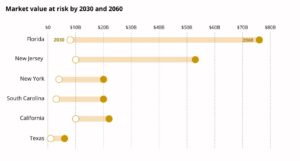
The rising sea level is putting a trillion dollars of real estate at high risk.

“The question is no longer if rising seas will erode coastal home values, but who will get stuck with the devalued assets when the markets turn,” reported Dee Gill.

“Alarmingly, more than half of that (at-risk property) exposure is estimated to lie outside FEMA flood zones. That means those properties are at higher risk of being underinsured, and, therefore, the loans attached to them are at higher risk of impairment, with increased risk for the value of the related CMBS (securities).” —CFTC

Market Value at Risk of Flooding

“Fannie and Freddie carry about $5.6 trillion in assets, mainly home mortgages and related securities. Ultimately, taxpayers backstop the payments on loans under the agencies’ control, UCLA’s Yu explains. Their regulator, the Federal Housing Finance Agency, issued a request for information in January, in part to assess flood risks. The entities require flood insurance that might mitigate their losses only on properties inside FEMA’s poorly drawn flood zones. Coverage limits imposed by NFIP — $250,000 for the structure and $100,000 for personal property — mean many coastal homes that have coverage are grossly underinsured.” — UCLA / Is the $1 Trillion Coastal Housing Market a Future Financial Crisis?

BlackRock, the G20-backed Financial Stability Board and the U.S. Commodity Futures Trading Commission are voicing concerns about unflagged flood risks squirreled away in mortgage-backed securities, bond markets and other real estate-backed investments. Common themes: The exact size of exposure is elusive but big; markets don’t currently price for it; these assets pose a threat to the stability of the global financial system.

More on Flood Insurance and Real Estate Risk

bookmark_borderNational Flood Insurance Program Increasing Rates

FEMA is updating the National Flood Insurance Program’s (NFIP) risk rating methodology through the implementation of a new pricing methodology called Risk Rating 2.0. The methodology leverages industry best practices and cutting-edge technology to enable FEMA to deliver rates that are actuarily sound, equitable, easier to understand and better reflect a property’s flood risk.

The Bradenton Herald reports, “More than a million Floridians will see their flood insurance premium rise next year, FEMA said Thursday.

The good news is, most will see increases of less than $120 a year. The bad news is that homeowners will likely see annual rate hikes like that for the foreseeable future.

The new strategy is meant to help pull the program out of its $20 billion debt and encourage people to live in safer, less flood-prone homes.

The new program will stop charging flood insurance premiums based solely on whether a home is within or outside of a flood zone and instead consider a range of factors like distance from the ocean, rainfall flooding and the cost to rebuild a home.

Starting April 2022, this pricing revamp will lead to higher prices for a majority of Florida’s 1.7 million policyholders — the most of any state — as well as a decrease for about 20% of policies, more than 340,000 policyholders.

“It allows us to set accurately sound rates and communicate flood risk better than we ever have before,” David Maurstad, senior executive of FEMA’s National Flood Insurance Program.

More articles on Flood Insurance, Rising Sea Levels and Global Warming.