In a new release from the World Health Organization (WHO), “air pollution levels remain dangerously high.” Updated estimations reveal an alarming death toll of 7 million people every year caused by ambient (outdoor) and household air pollution.
Dr. Tedros Adhanom Ghebreyesus, Director-General of WHO said, “It is unacceptable that over 3 billion people – most of them women and children – are still breathing deadly smoke every day from using polluting stoves and fuels in their homes. If we don’t take urgent action on air pollution, we will never come close to achieving sustainable development.”
Key findings:
WHO estimates that around 90% of people worldwide breathe polluted air. Over the past 6 years, ambient air pollution levels have remained high and approximatively stable, with declining concentrations in some part of Europe and in the Americas.
The highest ambient air pollution levels are in the Eastern Mediterranean Region and in South-East Asia, with annual mean levels often exceeding more than 5 times WHO limits, followed by low and middle-income cities in Africa and the Western Pacific.
Africa and some of the Western Pacific have a serious lack of air pollution data. For Africa, the database now contains PM measurements for more than twice as many cities as previous versions, however data was identified for only 8 of 47 countries in the region.
Europe has the highest number of places reporting data.
In general, ambient air pollution levels are lowest in high-income countries, particularly in Europe, the Americas and the Western Pacific.In cities of high-income countries in Europe, air pollution has been shown to lower average life expectancy by anywhere between 2 and 24 months, depending on pollution levels.
The right to the free flow of water has long maintained “public right-of-way easements” in the United States. In general, if a waterway is navigable, it is a public right-of-way; however, the results of climate change and rising sea levels have turned people’s private property into navigable waterways.
America’s coastal cities are preparing for legal battles over real estate that slips into the ocean.
A decade after the global financial crisis popularized the term “underwater real estate,” parts of the U.S. are grappling with a new, more literal version of that problem.
“There’s no question it will be a huge fight,” says Holly Doremus, a law professor at the University of California at Berkeley who specializes in environmental law. “We don’t exactly know the boundaries of what the state can do.” For centuries, a body of law called the public trust doctrine has stipulated that, when it comes to coastal property, anything below the average high-tide line is owned by the government for the use and benefit of the public. Those rules also cover what happens when the high-tide line moves. If that movement happens suddenly—for example, if a portion of beach is washed away by a storm—the land owner retains title to the property provided he or she restores it to dry land.
One of the most notable changes in weather doing to global warming is volatility. “We are not saying that the Earth’s temperature is just going to rise. In general, as energy is added to a system, the fluctuations in the system increase. So, we expect more storms, more droughts, more wildfires, more floods, more fluctuations of all kinds. What we are saying is that weather conditions will become more volatile due to the impact of humans,” said Sidd Mukherjee and Daniel Brouse of The Membrane Domain (2004). The increase in extreme weather events wreak havoc on humans’ ability to adapt to the changing environment. For instance, severe droughts followed by severe rains create devastating floods.
Mediterranean climate regimes are particularly susceptible to rapid shifts between drought and flood—of which, California’s rapid transition from record multi-year dryness between 2012 and 2016 to extreme wetness during the 2016–2017 winter provides a dramatic example. Projected future changes in such dry-to-wet events, however, remain inadequately quantified, which we investigate here using the Community Earth System Model Large Ensemble of climate model simulations. Anthropogenic forcing is found to yield large twenty-first-century increases in the frequency of wet extremes, including a more than threefold increase in sub-seasonal events comparable to California’s ‘Great Flood of 1862’. Smaller but statistically robust increases in dry extremes are also apparent. As a consequence, a 25% to 100% increase in extreme dry-to-wet precipitation events is projected, despite only modest changes in mean precipitation. Such hydrological cycle intensification would seriously challenge California’s existing water storage, conveyance and flood control infrastructure.
Boulder Colorado is suing Exxon and Suncor to recover costs of climate change adaptation.
“The average person should know we’re finally dealing with the costs of climate change. Irrespective of weather, this is a big concern to you,” said Richard Wiles, the executive director of the Centre for Climate Integrity.
“If your city or state is suddenly facing hundreds of millions of dollars — or billions of dollars — of adaptation costs over the next several years, that puts climate change in a different light. It suddenly becomes very real to you.”
“The main thing that is driving all of the risks that Boulder is talking about is still undeniably heat. Heat is what is behind the impacts they describe,” Mr Wiles said. “They’re talking about drought, about wildfires, about water availability. But it all comes down to heat.”
“Our communities and our taxpayers should not shoulder the cost of climate change adaptation alone. These oil companies need to pay their fair share,” Suzanne Jones, the mayor of the City of Boulder, said in a statement.
Climate change is causing extreme weather events. In addition, climate change is causing the sea level to rise.
In an article for Phys.org, anthropologist David Casagrande asks, “When people’s homes are damaged by flooding year after year and they are offered a buyout, why don’t they leave?”
“In some cases, houses on Smith Island in the Chesapeake Bay have been in families for thirteen generations. They’re not going anywhere.”
Casagrande employs cognitive dissonance theory to identify the rationales that residents employ to “avoid having to make really difficult decisions”—such as leaving.
“On Smith Island, for example, many people blame the U.S. Army Corps of Engineers for not doing a better job of preventing erosion. There is an erosion problem, but that is not the only challenge.”
“the height of what constitutes a 50-year flood event has risen by more than 10 centimeters per decade in some places”
“A rule of thumb holds that the frequency of events can be extrapolated up to four times as far into the future as the observational record reaches backward. A few decades of data won’t be sufficient to inform forecasts for a 10,000-year flood event, as is required for some communities and for sensitive infrastructure such as nuclear power plants.”
“[Re: Boston] what was a 100-year event in the 1820s is now more like an 8-year event”
“the coasts of the contiguous United States will fare differently. In eastern cities such as New York City and Charleston, South Carolina, it is the nuisance flooding that will become more frequent. By contrast, western cities such as Seattle in Washington, and San Diego in California, should expect more-frequent flooding from extreme events.”
“While many states have affirmed their commitment to strong building codes, in others there is a concerning lack of progress in the adoption and enforcement of updated residential building code systems. Because residential building codes represent a minimum life-safety standard for occupancy, the findings suggest that many homes remain at risk from severe hurricane events.”
Below are the 2018 state scores, based on a 100-point scale, where 100 is the best available score:
If you purchase real estate in a flood plain and obtain a mortgage, you will be required to purchase flood insurance.
Roy Wright oversees the Federal Emergency Management Agency’s (FEMA) National Flood Insurance Program. In a presentation to the Insurance-& Risk-Linked Securities Conference, Wright said to forget about checking the flood plain maps and check your drivers license. “If it says Florida, you need flood insurance.” FEMA is examining properties on coasts and in flood plains that have been repeatedly rebuilt “that we probably shouldn’t be providing coverage on.”
The national flood insurance program is now $20 billion in debt, largely because of Irma and other catastrophic storms like Harvey. Wright, during a break in the insurance conference, sat down with the Miami Herald to outline a plan to stabilize a troubled federal program vital to Florida’s real estate industry. It includes ambitious goals to double enrollment over the next five years amid a major makeover that will include more aggressive purchases of re-insurance and catastrophe bonds.
By law, only homes with federally-backed mortgages in high-risk zones are required to have insurance.
The National Flood Insurance Program provides nearly three times the number of policies in Florida as any other state.
National Flood Insurance Program
In the lead-up to Irma, an Associated Press analysis found that the number of Florida homes covered in high-risk areas had dropped by 15 percent in the previous five years. Fewer than half in hazard zones were protected from flood damage.
Wright blamed the problem partly on flood maps that, like hurricane tracking maps, can mislead homeowners on actual risks.
“We really gotta help people move beyond and quit focusing just on the lines,” he said. “Because nature, the day it rains, pays no attention to the lines.”
By contrast, when Harvey slammed the Texas coast, the national flood program insured 70 percent of the homes in moderate flood zones in Harris County. After the storm passed, 60 percent of the claims came from those moderate zones, proof that storms don’t always follow the contours of a flood map, Wright said.
“That’s true in areas of Florida as well,” he said.
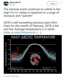
The North Pole saw record high temperatures for February during 2018.
Record Temperature at North Pole
Reuters reported:
Temperatures may have soared as high as 35 degrees Fahrenheit (2 degrees Celsius) at the pole, according to the U.S. Global Forecast System model. While there are no direct measurements of temperature there, Zack Labe, a climate scientist working on his PhD at the University of California at Irvine, confirmed that several independent analyses showed “it was very close to freezing,” which is more than 50 degrees (30 degrees Celsius) above normal.
The warm intrusion penetrated right through the heart of the Central Arctic, Labe said. The temperature averaged for the entire region north of 80 degrees latitude spiked to its highest level ever recorded in February. The average temperature was more than 36 degrees (20 degrees Celsius) above normal. “No other warm intrusions were very close to this,” Labe said in an interview, describing a data set maintained by the Danish Meteorological Institute that dates back to 1958. “I was taken by surprise how expansive this warm intrusion was.”
Climate scientist Sidd Mukherjee added, “Yes. Even more scarily — the fast ice north of Greenland is gone. That was some of the oldest ice left. It hasn’t melted, just been blown away and drifted away with the currents.” (see “Talk about unprecedented“)
An article in Rolling Stone about climate migrations quotes Solomon Hsiang:
Hsiang has many good papers outAn article in Rolling Stone about climate migrations quotes Solomon Hsiang:
“Most people don’t realize how much climate affects everything, from their property values to how hard people work,” says Solomon Hsiang, a professor of public policy at the University of California, Berkeley, who led a recent study that predicts, as the climate warms, there will be “a large transfer of value northward and westward.” And the wealthy, who can afford to adapt, will benefit, while the poor, who will likely be left behind, will suffer. “If we continue on the current path,” Hsiang says, “our analysis suggests that climate change may result in the largest transfer of wealth from the poor to the rich in the country’s history.”
Dr. Mukherjee replied, “But for city officials in at-risk cities, homeowners like Brown are terrifying. “Once people start thinking about the long-term value of their homes and how they will be impacted by climate change, that changes the game completely,” a county attorney in Florida says. What happens to the value of a house in, for instance, Fort Lauderdale, when the cost of flood insurance triples? “When I think about the future of South Florida, it’s flood insurance that scares me the most,” Wayne Pathman, a prominent Miami lawyer and board member of Miami Beach’s chamber of commerce, tells me. Many officials fear a climate-driven exodus that pushes down property values, which in turn reduces property-tax revenues, which are central to funding city services like police and teachers, not to mention road repair and infrastructure maintenance, at precisely the moment when the city needs to spend more to adapt to climate change.
Flooding in downtown Miami after Hurricane Irma in September 2017. Kadir van Lohuizen/NOOR/Redux
It’s a downward spiral for real estate that’s very hard to reverse. “It’s just like the dynamic in the stock market,” says U.C. Berkeley’s Hsiang. “The longer you hold on, the more you have to lose.” And, in many cases, the regions of the country where climate-change denial is strongest, such as the Southeast, are exactly the regions where residents have the most to lose. “In many places, climate denial is going to turn out to have big economic consequences,” Hsiang says.
[Hsiang has many good papers out]
In a recent study by Matthias Mengel, Alexander Nauels, Joeri Rogelj & Carl-Friedrich Schleussner entitled “Committed sea-level rise under the Paris Agreement and the legacy of delayed mitigation action” published in the Journal Nature, the authors contend — sea levels will rise between 0.7 and 1.2 meters (27-47 inches) in the next two centuries even if governments end the fossil fuel era as committed to under the Paris climate agreement.
THE ABSTRACT
Sea-level rise is a major consequence of climate change that will continue long after emissions of greenhouse gases have stopped. The 2015 Paris Agreement aims at reducing climate-related risks by reducing greenhouse gas emissions to net zero and limiting global-mean temperature increase. Here we quantify the effect of these constraints on global sea-level rise until 2300, including Antarctic ice-sheet instabilities. We estimate median sea-level rise between 0.7 and 1.2 m, if net-zero greenhouse gas emissions are sustained until 2300, varying with the pathway of emissions during this century. Temperature stabilization below 2 °C is insufficient to hold median sea-level rise until 2300 below 1.5 m. We find that each 5-year delay in near-term peaking of CO2 emissions increases median year 2300 sea-level rise estimates by ca. 0.2 m, and extreme sea-level rise estimates at the 95th percentile by up to 1 m. Our results underline the importance of near-term mitigation action for limiting long-term sea-level rise risks.
A 3-foot rise in sea level would put much of the United States’ East Coast, Florida and New Orleans underwater.