bookmark_borderManaged Retreat: Relocating Due to Climate Change Extreme Weather Events

The Politico article Dream homes and disasters: Is the government ready to confront climate risk? explains the need for “Managed Retreat”.

“The fact that official Washington is finally addressing the concept of some areas being too vulnerable to insure is noteworthy….”

“For decades, lawmakers and federal agencies in Washington, D.C., have resisted taking harsh action to pull federal insurance funding from especially vulnerable areas, even as climate change made a mockery of 100-year projections…. Now, in the wake of disasters including the deadly Kentucky floods and Hurricane Ian, official Washington is openly wrestling with what to do about the hundreds of thousands of people who are living in areas that climate change is making too risky to inhabit.”

“If large numbers of communities are rendered undesirable because of their climate, local and regional real estate markets could tank. Expensive public infrastructure like water treatment systems and roads could be abandoned or become obsolete as people relocate. Heavy taxpayer spending is likely. Yet many experts say that proactively steering people away from places climate change is making nonviable will seem a bargain compared with the costs of rebuilding in the shadow of past and future disasters, floods and droughts.”

“… as climate change makes disasters more frequent and severe, a once-taboo strategy known as “managed retreat” is getting more serious consideration in Congress and the federal government.”

“Human beings are terrible at assessing risk,” Kralicek (the emergency manager for Tulsa and Tulsa County) said. “We’re awful at it. Which is why things like casinos do so well.”

Recent federal policy changes might help to limit those losses. But until there’s a wholesale rethink of how — and where — cities, towns and counties develop, there will be more hardship.

“The piper is gonna come call, and at some point you got to pay,” Kralicek added. “And you just got to figure out who’s paying.”

Making people pay
One way to push people to make rational decisions is to force them to pay more if they don’t.

In October 2021, FEMA rolled out its long-awaited revamp to the federal flood insurance program, known as Risk Rating 2.0. The effort aims to align insurance premium pricing with the actual flood risk homes face. FEMA hopes doing so will limit losses to the chronically indebted, taxpayer-funded federal flood insurance program and also signal to would-be homeowners that some places face significant danger.

“There is no greater risk-communication tool than a pricing signal. When we distort the price, we distort their understanding of risk,” said Wright, the former FEMA flood insurance chief.

Risk Rating 2.0: Equity in Action
FEMA Flood Insurance Risk Rating 2.0

FEMA is updating the National Flood Insurance Program’s (NFIP) risk rating methodology through the implementation of a new pricing methodology called Risk Rating 2.0.

FEMA is committed to building a culture of preparedness across the nation. Purchasing flood insurance is the first line of defense against flood damage and a step toward a quicker recovery following a flood.

Since the 1970s, rates have been predominantly based on relatively static measurements, emphasizing a property’s elevation within a zone on a Flood Insurance Rate Map (FIRM).

This approach does not incorporate as many flooding variables as Risk Rating 2.0. Risk Rating 2.0 is not just a minor improvement, but a transformational leap forward. Risk Rating 2.0 enables FEMA to set rates that are fairer and ensures rate increases and decreases are both equitable.

FEMA is building on years of investment in flood hazard information by incorporating private sector data sets, catastrophe models and evolving actuarial science.

With Risk Rating 2.0, FEMA now has the capability and tools to address rating disparities by incorporating more flood risk variables. These include flood frequency, multiple flood types—river overflow, storm surge, coastal erosion and heavy rainfall—and distance to a water source along with property characteristics such as elevation and the cost to rebuild.

Currently, policyholders with lower-valued homes are paying more than their share of the risk while policyholders with higher-valued homes are paying less than their share of the risk. Because Risk Rating 2.0 considers rebuilding costs, FEMA can equitably distribute premiums across all policyholders based on home value and a property’s unique flood risk.

Rates can increase 18% per year.

More articles on Flood Insurance, Extreme Weather Events and Global Warming.
bookmark_borderFloridians: You’re At Risk of Flooding

If you purchase real estate in a flood plain and obtain a mortgage, you will be required to purchase flood insurance.

Roy Wright oversees the Federal Emergency Management Agency’s (FEMA) National Flood Insurance Program. In a presentation to the Insurance-& Risk-Linked Securities Conference, Wright said to forget about checking the flood plain maps and check your drivers license. “If it says Florida, you need flood insurance.” FEMA is examining properties on coasts and in flood plains that have been repeatedly rebuilt “that we probably shouldn’t be providing coverage on.”

The Miami Herald reported:

The national flood insurance program is now $20 billion in debt, largely because of Irma and other catastrophic storms like Harvey. Wright, during a break in the insurance conference, sat down with the Miami Herald to outline a plan to stabilize a troubled federal program vital to Florida’s real estate industry. It includes ambitious goals to double enrollment over the next five years amid a major makeover that will include more aggressive purchases of re-insurance and catastrophe bonds.

By law, only homes with federally-backed mortgages in high-risk zones are required to have insurance.

us flood map1
The National Flood Insurance Program provides nearly three times the number of policies in Florida as any other state.
National Flood Insurance Program

In the lead-up to Irma, an Associated Press analysis found that the number of Florida homes covered in high-risk areas had dropped by 15 percent in the previous five years. Fewer than half in hazard zones were protected from flood damage.

Wright blamed the problem partly on flood maps that, like hurricane tracking maps, can mislead homeowners on actual risks.

“We really gotta help people move beyond and quit focusing just on the lines,” he said. “Because nature, the day it rains, pays no attention to the lines.”

By contrast, when Harvey slammed the Texas coast, the national flood program insured 70 percent of the homes in moderate flood zones in Harris County. After the storm passed, 60 percent of the claims came from those moderate zones, proof that storms don’t always follow the contours of a flood map, Wright said.

“That’s true in areas of Florida as well,” he said.


bookmark_borderSan Francisco Bay’s Double Whammy

by Daniel Brouse and Sidd Mukherjee

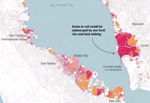
Coastal communities are being forced to adapt to rising sea levels; however, San Francisco has an even bigger problem — sinking land. In a report published in Science Advances (07 Mar 2018: Vol. 4, no. 3, eaap9234 / DOI: 10.1126/sciadv.aap9234), the Bay Area has to face both rising sea levels and sinking land.

The report indicates that the sinking land (called land subsidence) will increase the reach and damage of flooding in the Bay Area. The impact will be more dramatic than predicted in the forecasts for 2100.

“It’s a very well-known problem, but we really don’t know how fast it’s going to be in the second half of the 21st century. This is a projection,” Dr. Shirzaei said.

San Fransisco Bay Circa 2100

Abstract

by Manoochehr Shirzaei and Roland Bürgmann

The current global projections of future sea level rise are the basis for developing inundation hazard maps. However, contributions from spatially variable coastal subsidence have generally not been considered in these projections. We use synthetic aperture radar interferometric measurements and global navigation satellite system data to show subsidence rates of less than 2 mm/year along most of the coastal areas along San Francisco Bay. However, rates exceed 10 mm/year in some areas underlain by compacting artificial landfill and Holocene mud deposits. The maps estimating 100-year inundation hazards solely based on the projection of sea level rise from various emission scenarios underestimate the area at risk of flooding by 3.7 to 90.9%, compared with revised maps that account for the contribution of local land subsidence. Given ongoing land subsidence, we project that an area of 125 to 429 km2 will be vulnerable to inundation, as opposed to 51 to 413 km2 considering sea level rise alone.

The flood risks across the whole USA are seriously underestimated

The following paper covers all flood risk, not just the coasts, but inland and all the causes including sea level rise as well as flooding rivers and large precipitation events outside watersheds.

doi: 10.1088/1748-9326/aaac65

http://iopscience.iop.org/article/10.1088/1748-9326/aaac65/meta

“Estimates of present and future flood risk in the conterminous United States”
Oliver E J Wing ,  Paul D Bates, Andrew M Smith, Christopher C Sampson, Kris A Johnson, Joseph Fargione  and Philip Morefield

Environ. Res. Lett. 13 (2018) 034023

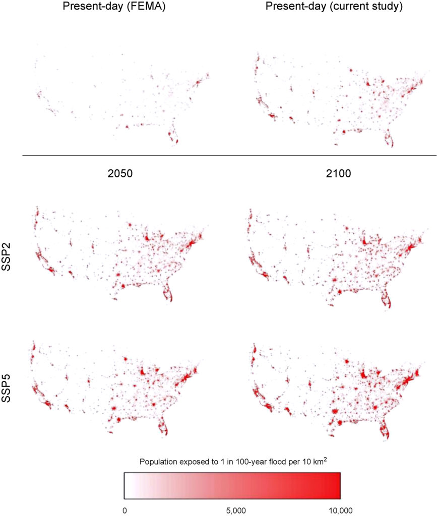
Wing et al. analyze flood risk in the US lower 48. Apparently 41 million are at risk rather than 13 million in current FEMA estimates.

WARNING: this paper specifically does not cover sea levels rise and increased precipitation.

“Our data show that the total US population exposed to serious flooding is 2.6–3.1 times higher than previous estimates, and that nearly 41 million Americans live within the 1% annual exceedance probability floodplain (compared to only 13 million when calculated using FEMA flood maps)”

“The analysis shows that 40.8 million people (13.3% of the population) are currently exposed to a 1 in 100 year (1% annual exceedance probability) fluvial or pluvial flood in the CONUS, which translates to a GDP exposure of $2.9 trillion (15.3% of total GDP)”

“This analysis indicates that previous estimates capture roughly one-third of the exposure identified in our 1 in 100 year floodplain.”

“It doesn’t take into account sea level rise and heavier rainfall expected to come along with climate change, so it likely underestimates the exposure, the authors warned.”

Revised Floodplain Map

https://www.houstonchronicle.com/news/houston-texas/houston/amp/28-million-Americans-live-in-flood-zones-and-12732279.php
Part of the study Who Pays For Flood Insurance?

bookmark_borderClimate Change Immigrants and Refugees

By Daniel Brouse

EARTH — As human induced climate change is realized, mammals have started showing patterns of migration. Some conditions are driving animals south due to the loss of their habitat (mostly animals living on ice, such as, seals and polar bears.) Some conditions are allowing animals to migrate further north (like humpback whales.) Some conditions are forcing animals to seek higher ground, as well as, escape salt water intrusion. (eg humans that live on islands)

* NOAA recently concluded that mammals are migrating due to global warming. “Humpback and fin whales are now able to go farther north in most winters, competing with beluga whales for resources,” a scientist for the National Oceanic and Atmospheric Administration said.

* The government of the Marshall Islands has requested climate change refugee status from the United States for former Bikini island residents. “The people of Bikini came back to us and asked us to take this proposal to the US, to request the resettlement trust fund be used to settle people in the US not just the Marshall Islands,” said Tony de Brum, Foreign Minister of the Marshall Islands. “We have not seen the final text of the legislation but the request that went in was on the basis of Kili being uninhabitable because of climate change.”

* In Paris almost 200 countries have ratified a new agreement in an attempt to help mitigate climate change. Included in the deal is $100bn fund to help developing and island countries adapt to global warming.

* Long ago in the United States, FEMA started a forced plan of relocation for homes located in areas prone to flooding.

Chances are large that if you are a mammal you will become a climate change refugee.

More on the Human Induced Climate Change Experiment

bookmark_borderOklahoma Tornado

One of the most severe tornadoes in recorded history wiped out part of Oklahoma. Lt. Gov. Todd Lamb described it like a “two-mile-wide lawnmower blade going over a community.”

A hospital and an elementary school were both leveled. At least 9 children were killed.

State Highway Patrol Trooper Betsy Randolph said it was “mass devastation. “I’m talking everywhere you looked, the debris field was so high, and so far and so wide, wounded people walking around the streets. They were bloody; there were people that had stuff sticking out of them from things that were flying around in the air. There were cars crumpled up like little toys and thrown on top of buildings. Buildings that were two and three stories tall that were leveled.”

“People are wandering around like zombies,” a reporter said. “It’s like they’re not realizing how to process what had just happened.”

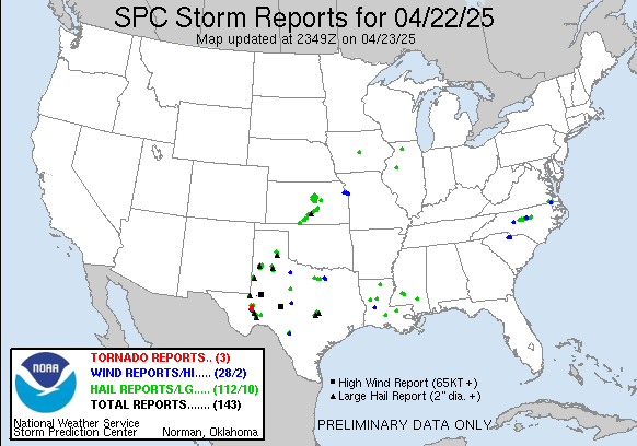
yesterday Reports Graphic

Tornado Reports (CSV) (Raw Tornado CSV)(?)
Time Location County State Lat Lon Comments
1956 NEWCASTLE MCCLAIN OK 3525 9760 LIFTED AROUND 336 PM. ESTIMATED PATH LENGTH OF 20 MILES THRU NEWCASTLE, MOORE, AND SOUTH OKC. PRELIMINARY DAMAGE RATING OF AT LEAST EF4. (OUN)
2056 3 S AVANT OSAGE OK 3645 9606 MULTIPLE SPOTTERS AND BROADCAST MEDIA REPORT A LARGE TORNADO ON THE GROUND THAT FIRST DEVELOPED NEAR AVANT AND CONTINUED NORTHEASTWARD INTO WASHINGTON COUNTY. A TORNADO (TSA)
2112 3 SW DEARING MONTGOMERY KS 3703 9574 BRIEF TOUCHDOWN ALONG HIGHWAY 166 NEAR COUNTY ROAD 3500. (ICT)
2130 1 W MEEKER LINCOLN OK 3550 9691 REPORTED BY KWTV (OUN)
2135 4 W TALALA ROGERS OK 3653 9577 REPORTED BY OKLAHOMA HIGHWAY PATROL (TSA)
2139 2 NE OWENS BROWN TX 3186 9891 TORNADO REPORTED BY HAM RADIO OPERATOR (SJT)
2205 5 SW MANTER STANTON KS 3747 10195 A LANDSPOUT TORNADO WAS REPORTED. ANOTHER PREVIOUS LANDSPOUT THAT OCCURRED AROUND 450PM HAD DISSIPATED. (DDC)
2205 1 S MANTER STANTON KS 3751 10188 A POSSIBLE LANDSPOUT TORNADO WAS REPORTED. ANOTHER PREVIOUS LANDSPOUT THAT OCCURRED AROUND 450PM HAD DISSIPATED. (DDC)
2210 5 SSE THE SAUNDERS ELEV STANTON KS 3740 10200 LANDSPOUT TORNADO REPORTED NEAR THE STATE LINE. (DDC)
2241 1 S RINGGOLD MONTAGUE TX 3381 9795 BRIEF TORNADO REPORTED 1 MILE SOUTH OF RINGGOLD. (FWD)
2245 BLANKET BROWN TX 3182 9879 DPS REPORTED A TORNADO ON THE GROUND IN THE COMMUNITY OF BLANKET. (SJT)
2253 10 NE MONTE VISTA ALAMOSA CO 3768 10601 BRIEF LANDSPOUT LASTED FOR ABOUT 5-6 MINUTES IN OPEN FIELD. (PUB)
2300 5 NNE ZEPHYR BROWN TX 3174 9876 TORNADO REPORTED AT RR-1467 AND CO-291 BY AMATEUR RADIO OPERATOR. (SJT)
2330 8 S QUAPAW OTTAWA OK 3684 9479 DAMAGE TO A DIESEL SHOP. NUMEROUS POWER POLES SNAPPED. SEMI TRAILERS BLOWN OFF THE ROAD. 50 TO 60 FOOT TREE ALSO BLOCKING A ROADWAY 3 MILES EAST OF TWIN BRIDGES LIKELY (TSA)
2336 3 E PROCTOR ADAIR OK 3597 9472 TORNADO REPORTED BY TRAINED SPOTTER AND COLOCATED WITH A STRONG RADAR CIRCULATION. TREES DOWN ON HIGHWAY 62. TORNADO MAY HAVE CONTINUED TO NEAR THE ILLINOIS RIVER BRIDG (TSA)
2349 2 N SILOAM SPRINGS BENTON AR 3622 9454 PHOTO OF A SMALL TORNADO RECEIVED. TREE DAMAGE WAS REPORTED IN THE AREA. TIME ESTIMATED VIA RADAR. (TSA)
0025 PRIDDY MILLS TX 3167 9852 S.O. REPORTS A TORNADO NEAR PRIDDY UPROOTED TREES. (FWD)
0029 HANNIBAL MARION MO 3971 9138 (LSX)
0032 HANNIBAL MARION MO 3971 9138 A SMALL HOLE IN THE ROOF AT THE HANNIBAL – LAGRANGE SCIENCE BUILDING WAS UNCOVERED AND NOT THE ENTIRE ROOF. (LSX)
0036 HANNIBAL MARION MO 3971 9138 THERE ARE SEVERAL LARGE TREES SNAPPED. – SEVERE DANAGE TO TWO MACHINE SHEDS NEAR HIGHWAY MM. SHINGLES REMOVED AT SOME BUILDINGS IN DOWNTOWN AREA. (LSX)
0132 5 WSW BOKOSHE LE FLORE OK 3516 9487 REPORT FROM LAW ENFORCEMENT RADIO OF A TORNADO BETWEEN MCCURTAIN AND BOKOSHE COLOCATED WITH A STRONG RADAR CIRCULATION. BROADCAST MEDIA REPORTED POWER FLASHES IN THE AR (TSA)
0150 CAMERON LE FLORE OK 3513 9453 LAW ENFORCEMENT RADIO REPORTED A TORNADO NEAR CAMERON COLOCATED WITH A STRONG RADAR CIRCULATION. IT MAY HAVE CONTINUED TO THE ROCK ISLAND VICINITY. EMERGENCY MANAGEMENT (TSA)