bookmark_borderViolent Rain and the Substrate

Daniel Brouse asked:
As the sea levels rise, how far “inland” might we see salinization of fresh water? Is it possible saltwater could infiltrate the Great Lakes?

  • Lake Superior has an elevation of 600 feet above (current) sea level and a depth of 1,332 feet.
  • Lake Ontario is 243 feet above sea level with a depth of 802 feet.
The Great Lakes
The Great Lakes

Greg Laden:
Would not reach the Great lakes, but with a little erosion, the Hudson, Lake Champlain, and the St Lawrence could become contiguous, so New England becomes an Island.

Daniel Brouse:
Thanks! I am particularly interested in the Kennebecasis River (a tributary of the Saint John River in southern New Brunswick, Canada.) Your answer is what I was looking for. Do you have any thoughts on this process… in particular, the changing topography caused by extreme rain events? You can kind-of imagine Eastern and Western North America as giant beaches with ever increasing atmospheric waves splashing down on us. The Gulf Coast will be hit from both sides. We to see increasing intensity and/or frequency in a wide variety of violent rain events including: downpours, flooding, hurricanes, cyclones, monsoons, coastal flooding, storm surges, lightning and wildfires, hail, extreme wind, and concurrent extremes. The reign of violent rain has already begun. More hillsides and shorelines are collapsing. Atmospheric rivers are dramatically increasing flash flooding in the Northeastern USA. Worldwide, stormwater systems are becoming overwhelmed. Ironically, the streets of Abu Dhabi and Dubai, UAE, flooded days before the COP28 Climate Conference. Nowhere is safe from violent rain, not even in the desert preparing for a UN meeting on the climate crisis. As a result of increasing violent rain, new drainage culverts are forming. Eventually, the culverts will transform into recurring streams, carving new canyons, creating new landscapes and islands. Increased wildfires and landslides will transform topography. At the same time as the violent rain makes its way to the sea, the sea is rising to meet the violent rain. What do you think will happen to the floodplains in North America?

Greg Laden:
I have many thoughts on this, and this has been part of my research and study for a very long time, having done coastal archaeology in North America, etc. The basic question is what is the substrate? Sea level rise of 1 meter in Maine means the sea goes up to the top line that is currently 1 meter above the sea (we are ignoring tides) and that’s it for thousands of years. That is because Maine is made out of granite. Sea level rise of 1 meter along Cape Cod, which is glacial till, means that the sea will erode horizontally many many meters. In fact, Cape Cod is a dead-peninsula walking, even given pre-AGW sea level rise. It will all wash away eventually, except any rocky bits of bedrock that might be there (but they aren’t there AFIK) So, given that, yes, storms come in to play. The rate of erosion of Cap Cod, to continue with that example, accelerated in about 1979, due to increased severe coastal storm. What happens to a given floodplain will depend totally on local conditions. Many of our floodplains are not that often flooded, especially in glacial zones where they are filled up, and lower reaches of the giant rivers, and there is a lot of infrastructure in place that will initially control things.

Daniel Brouse:
You might be interested in King of Prussia and Plymouth Meeting, PA. The train derailment in Plymouth Meeting (July 17, 2023) was caused by extreme rainfall and flash flooding that resulted in sinkholes developing in the carbonate rock under the railroad tracks. In July and December of 2023, extreme rainfall resulted in sinkholes being exposed in the carbonate rock under Route 202 in King of Prussia, PA. I guess this is part of the local conditions that vary widely from location to location?

ALSO SEE: Plymouth Meeting, Pennsylvania and the Creation of the Climate Crisis / Daniel Brouse (2023)
The Reign of Violent Rain

Greenland and the Collapse of the East Antarctic Ice Sheet

Sea Level Rise: Then and Now

Climate Change: Rate of Acceleration

Flood Insurance

The Human Induced Climate Change Experiment

bookmark_borderSan Francisco Bay’s Double Whammy

by Daniel Brouse and Sidd Mukherjee

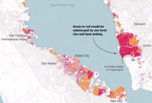
Coastal communities are being forced to adapt to rising sea levels; however, San Francisco has an even bigger problem — sinking land. In a report published in Science Advances (07 Mar 2018: Vol. 4, no. 3, eaap9234 / DOI: 10.1126/sciadv.aap9234), the Bay Area has to face both rising sea levels and sinking land.

The report indicates that the sinking land (called land subsidence) will increase the reach and damage of flooding in the Bay Area. The impact will be more dramatic than predicted in the forecasts for 2100.

“It’s a very well-known problem, but we really don’t know how fast it’s going to be in the second half of the 21st century. This is a projection,” Dr. Shirzaei said.

San Fransisco Bay Circa 2100

Abstract

by Manoochehr Shirzaei and Roland Bürgmann

The current global projections of future sea level rise are the basis for developing inundation hazard maps. However, contributions from spatially variable coastal subsidence have generally not been considered in these projections. We use synthetic aperture radar interferometric measurements and global navigation satellite system data to show subsidence rates of less than 2 mm/year along most of the coastal areas along San Francisco Bay. However, rates exceed 10 mm/year in some areas underlain by compacting artificial landfill and Holocene mud deposits. The maps estimating 100-year inundation hazards solely based on the projection of sea level rise from various emission scenarios underestimate the area at risk of flooding by 3.7 to 90.9%, compared with revised maps that account for the contribution of local land subsidence. Given ongoing land subsidence, we project that an area of 125 to 429 km2 will be vulnerable to inundation, as opposed to 51 to 413 km2 considering sea level rise alone.

The flood risks across the whole USA are seriously underestimated

The following paper covers all flood risk, not just the coasts, but inland and all the causes including sea level rise as well as flooding rivers and large precipitation events outside watersheds.

doi: 10.1088/1748-9326/aaac65

http://iopscience.iop.org/article/10.1088/1748-9326/aaac65/meta

“Estimates of present and future flood risk in the conterminous United States”
Oliver E J Wing ,  Paul D Bates, Andrew M Smith, Christopher C Sampson, Kris A Johnson, Joseph Fargione  and Philip Morefield

Environ. Res. Lett. 13 (2018) 034023

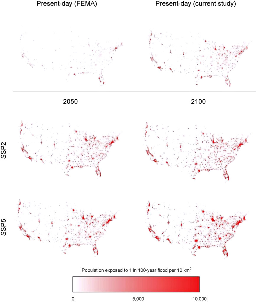
Wing et al. analyze flood risk in the US lower 48. Apparently 41 million are at risk rather than 13 million in current FEMA estimates.

WARNING: this paper specifically does not cover sea levels rise and increased precipitation.

“Our data show that the total US population exposed to serious flooding is 2.6–3.1 times higher than previous estimates, and that nearly 41 million Americans live within the 1% annual exceedance probability floodplain (compared to only 13 million when calculated using FEMA flood maps)”

“The analysis shows that 40.8 million people (13.3% of the population) are currently exposed to a 1 in 100 year (1% annual exceedance probability) fluvial or pluvial flood in the CONUS, which translates to a GDP exposure of $2.9 trillion (15.3% of total GDP)”

“This analysis indicates that previous estimates capture roughly one-third of the exposure identified in our 1 in 100 year floodplain.”

“It doesn’t take into account sea level rise and heavier rainfall expected to come along with climate change, so it likely underestimates the exposure, the authors warned.”

Revised Floodplain Map

https://www.houstonchronicle.com/news/houston-texas/houston/amp/28-million-Americans-live-in-flood-zones-and-12732279.php
Part of the study Who Pays For Flood Insurance?