bookmark_borderDeath Toll in Indian Monsoon Flooding

The severe weather event in India has a rising death toll. Currently at 500, it is expected to rise to over 1,000. More than 60,000 people have been stranded.

” Uttrakhand state Chief Minister Vijay Bahguna said 556 bodies have been noticed buried deep in slush and the army was trying to recover them. He spoke to CNN-IBN television channel on Friday.

Rescuers also Friday found 40 bodies floating in the Ganges near Haridwar, a Hindu holy city, said police officer Rajiv Swaroop.

Bahguna said the eventual toll would be in the hundreds. Rakesh Sharma, another state official, had said Thursday the death toll might reach the thousands but the exact figure would not be known until the entire region is checked.

Home Minister Sushilkumar Shinde told reporters in New Delhi that 34,000 people have been evacuated so far and another 50,000 were stranded in the region. Roads and bridges were washed away by the floods or blocked by debris.”

More information on the effects of global warming and climate change.

bookmark_borderColorado Wildfires

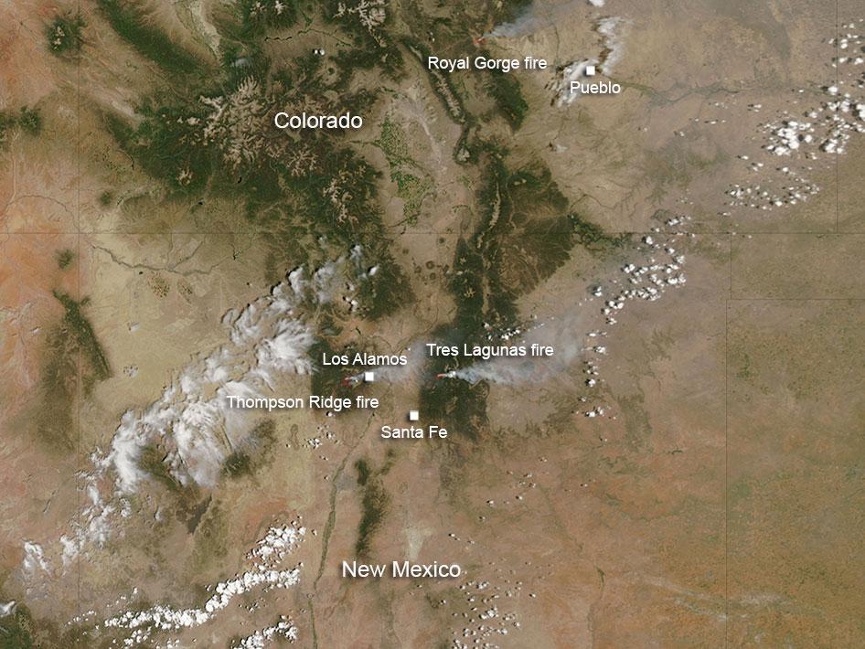
Over 500 homes have been destroyed in the Colorado wildfires. According to NASA: The Royal Gorge fire in Colorado was first reported at 1 p.m. Tuesday June 11, south of the Royal Gorge Bridge and Arkansas River. It is estimated at 3800 acres. At present the Arkansas River has been closed from Spike Buck through Canon City. The Royal Gorge Bridge and Park has been evacuated.

Resources on scene include: 150 firefighters and Law Enforcement officers from both federal and local departments. Resources ordered include: 2-Single Engine Airtanker and 1 Heavy Air Tanker.

The cause of the fire is under investigation.

The New Mexico fires include Thompson Ridge and Tres Lagunas fires. There is another fire in New Mexico south of the area where these fires are located, and that fire is known as the Silver fire. It is not visible in this image, although in the larger image that is included, it is visible.

The Thompson Ridge fire started on May 31, 2013. The cause was human in nature. It is located on the Valles Caldera National Preserve about two miles northeast of La Cueva, New Mexico. The fire is in steep rugged terrain and is burning mixed conifer and ponderosa pine. It has currently burned over 21,000 acres and is 50% contained. However, the growth potential for this fire is high due to rugged terrain, low humidity and dry conditions. Total personnel working this fire is 991.

The Tres Lagunas fire which started on May 30, 2013 was caused by human error and a downed power line. Currently it has burned over 10,000 acres. This fire is 10 miles north of Pecos, New Mexico.

There is a red flag warning for the area today which heralds hot, dry conditions with temperatures remaining well above normal. Stronger and gustier west/southwest winds are expected today with low humidity. All these conditions can contribute to fire growth. At this time the fire is 77% contained.

At present 14 Hand Crews, 5 Helicopters, 17 engines, 2 bulldozers, and 4 water tenders are fighting this fire.

This natural-color satellite image was collected by the Moderate Resolution Imaging Spectroradiometer (MODIS) on June 11, 2013. Actively burning areas, detected by MODIS’s thermal bands, are outlined in red.

NASA image courtesy Jeff Schmaltz, MODIS Rapid Response Team. Caption: NASA/Goddard, Lynn Jenner

colorado-wildfires-2013

bookmark_borderClimate Change Pearls of Wisdom

Learn more about global warming.

World Oceans Month Brings Mixed News for Oysters
by the National Science Foundation

Ocean acidification inhibits shell formation, but interventions at hatcheries may offset some effects, scientists find

In World Oceans Month, there’s mixed news for the Pacific Northwest oyster industry.

For the past several years, it has struggled with significant losses due to ocean acidification. Oyster larvae have had mortality rates high enough to render production no longer economically feasible.

Now a new study documents why oysters appear so sensitive to increasing acidity, but also offers some hope for the future.

It isn’t necessarily a case of acidic water dissolving the oysters’ shells, scientists say. It’s water high in carbon dioxide altering shell formation rates, energy usage and, ultimately, the growth and survival of young oysters.

“The failure of oyster seed production in Northwest Pacific coastal waters is one of the most graphic examples of ocean acidification effects on important commercial shellfish,” said Dave Garrison, program director in the National Science Foundation’s (NSF) Division of Ocean Sciences.

NSF funded the study through its Ocean Acidification Program, part of NSF’s Science, Engineering and Education for Sustainability programs.

“This research is among the first to identify the links among organism physiology, ocean carbonate chemistry and oyster seed mortality,” said Garrison.

Results of the study are online in the journal Geophysical Research Letters, published by the American Geophysical Union.

“From the time eggs are fertilized, Pacific oyster larvae precipitate roughly 90 percent of their body weight as a calcium carbonate shell within 48 hours,” said George Waldbusser, an Oregon State University marine ecologist and lead author of the paper.

“Young oysters rely solely on the energy they derive from the egg because they have not yet developed feeding organs.”

During exposure to increasing carbon dioxide in acidified water, however, it becomes more energetically expensive for organisms like oysters to build shells.

Adult oysters and other bivalves may grow more slowly when exposed to rising carbon dioxide levels. But larvae in the first two days of life do not have the luxury of delayed growth.

“They must build their first shell quickly on a limited amount of energy–and along with the shell comes the organ to capture external food,” said Waldbusser.

“It becomes a death race of sorts. Can the oyster build its shell quickly enough to allow its feeding mechanism to develop before it runs out of energy from the egg?”

The results are important, marine scientists say, because they document for the first time the links among shell formation rate, available energy, and sensitivity to acidification.

The researchers say that the faster the rate of shell formation, the more energy is needed. Oyster embryos building their first shells need “to make a lot of shell on short order,” said Waldbusser.

“As the carbon dioxide in seawater increases, but before waters become corrosive, calcium carbonate precipitation requires more energy to maintain higher rates of shell formation during this early stage.”

The researchers worked with Whiskey Creek Shellfish Hatchery in Netarts Bay, Ore. They found that on the second day of life, 100 percent of the larval tissue growth was from egg-derived carbon.

“The oyster larvae were still relying on egg-derived energy until they were 11 days old,” said Elizabeth Brunner of Oregon State University and a co-author of the paper.

The earliest shell material in the larvae contained the greatest amount of carbon from the surrounding waters.

Increasing amounts of carbon from respiration were incorporated into shells after the first 48 hours, indicating an ability to isolate and control the shell surfaces where calcium carbonate is being deposited.

Waldbusser notes that adult bivalves are well-adapted to growing shell in conditions that are more acidified, and have evolved several mechanisms to do so.

These include use of organic molecules to organize and facilitate the formation of calcium carbonate, pumps that remove acid from the calcifying fluids, and outer shell coatings that protect minerals to some degree from surrounding waters.

Waldbusser said that the results help explain previous findings at the Whiskey Creek Hatchery of larval sensitivity to waters that are high in carbon dioxide but not corrosive to calcium carbonate.

They also explain carryover effects later in larval life of exposure to high carbon dioxide, similar to human neonatal nutrition effects.

The discovery may be good news, scientists say, because there are interventions that can be done at hatcheries that may offset some of the effects of ocean acidification.

Some hatcheries have begun “buffering” water for larvae–essentially adding antacids to incoming waters–including the Whiskey Creek Hatchery and the Taylor Shellfish Farms in Washington.

The study provides a scientific foundation for the target level of buffering.

“You can make sure that eggs have more energy before they enter the larval stage,” said Waldbusser, “so a well-balanced adult diet may help larval oysters cope better with the stress of acidified water.”

-NSF-
bookmark_borderBig Brother Is Watching: FBI and NSA Spying on You

Two newspapers, The Washington Post and the Guardian (UK), have published articles about the United States government invading the civil rights of its own citizens. The information was obtained from a “top secret” document and states that the National Security Agency and the FBI are collecting information directly from the servers of Microsoft, Yahoo, Google, Facebook, PalTalk, AOL, Skype, YouTube, Apple.


The National Security Agency and the FBI are tapping directly into the central servers of nine leading U.S. Internet companies, extracting audio and video chats, photographs, e-mails, documents, and connection logs that enable analysts to track foreign targets, according to a top-secret document obtained by The Washington Post.


Find out about connecting to the Internet through a secure private server.

More on cyber security and privacy.

bookmark_borderGlobal Warming Proof

by the Institute for Marine and Antarctic Studies

Ocean measurements taken more than 135 years ago during the scientific expedition of HMS Challenger have provided further confirmation of human-produced global warming over the past century.

The researchers also found the thermal expansion of sea water caused by this global warming contributed to around 40 per cent of the total sea level rise seen in tide gauges from 1873 to 1955. The remaining 60 per cent was likely to have come from the melting of ice sheets and glaciers.

“Our research revealed warming of the planet can be clearly detected since 1873 and that our oceans continue to absorb the great majority of this heat,” said lead author Dr Will Hobbs, a researcher at the University of Tasmania’s Institute for Marine and Antarctic Studies and the Australian Research Council’s Centre of Excellence for Climate System Science.

“Currently scientists estimate the oceans absorb more than 90 per cent of the heat trapped by greenhouse gases, and we attribute the global warming to anthropogenic causes.”

The Challenger expedition, from 1872-1876, was the world’s first global scientific survey of life beneath the ocean surface. Along the way scientists measured ocean temperatures, lowering thermometers hundreds of metres deep on ropes made from Italian hemp during its voyage.

Researchers combined these data with modern observations and used both in state-of-the-art climate models to get a picture of how the world’s oceans have changed since the Challenger’s voyage.

“The key to this research was to determine the range of uncertainty for the measurements taken by the crew of the Challenger,” said study co-author Josh Willis, a climate scientist at NASA’s Jet Propulsion Laboratory.

“After we had taken all these uncertainties into account, it became apparent that the rate of warming we saw across the oceans far exceeded the degree of uncertainty around the measurements.

“So, while the uncertainty was large, the warming signal detected was far greater.”

Uncertainties around the Challenger’s measurements were caused by the limited areas measured during the voyage; the actual depths the thermometers descended to and the likely natural variation in temperature that could occur in each region during the voyage.

To get the most reliable results the researchers used the most conservative estimates after taking into account the maximum possible variation caused by these uncertainties.

“Because we took the most conservative outcome, we are likely to have underestimated the true temperature rise,” said Dr Hobbs.

“A simple analysis of our results suggests we may have underestimated the warming by as much as 17 per cent. In fact many of the stations most prone to bias were in the Eastern Pacific – a region showing one of the strongest ocean warming trends – so the true warming may be even larger than that.”

In addition to determining the increase in temperatures, the measurements from the Challenger expedition revealed the amount of thermal expansion in sea level rise in the oceans before the 1950s. Prior to this research, climate models offered the only way to estimate the change.

“This research adds yet another suite of compelling data that shows human activity continues to have a dramatic influence on the Earth’s climate,” said Dr Hobbs.

bookmark_borderSevere Weather Events: Tornadoes

Because a tornado is part of a severe convective storm, and these storms occur all over the Earth, tornadoes are not limited to any specific geographic location. In fact, tornadoes have been documented in every state of the United States, and on every continent, with the exception of Antarctica (even there, a tornado occurrence is not impossible). In fact, wherever the atmospheric conditions are exactly right, the occurrence of a tornadic storm is possible. More on the conditions necessary for tornado formation can be found at the NOAA National Severe Storms Laboratory Tornado Page.

U.S. Statewide Average Tornado Map


Between April 25 and April 28, 2011, a record-breaking total of 362 tornadoes tore through the southeastern and central United States. Could climate change fuel such an unprecedented cluster of twisters? A number of commentators have addressed the question, but the most concise answer I’ve heard yet comes in the 36th minute of an On Point interview with NOAA tornado expert Harold Brooks.

On Point: When you look at the architecture of the weather that produced these storms can you tie it to global climate change? We’ve seen warning after warning saying that we may see an increase in storm conditions because of climate change.

Brooks: Well, the planet has undoubtedly warmed in the last 50 to 100 years. And it will undoubtedly continue to warm as greenhouse gases play a greater role. It’s not really clear what the connection is between tornadoes [and climate change] in particular. Some of the ingredients we look for in the production of supercells, such as the warm moist air at low levels, are going to increase in intensity and frequency and be supportive of supercell storms. On the other hand, one of the main predictions of climate change is that the equator to pole temperature difference will decrease because the poles will warm more than the equator. That’s related to the change of the winds with height term, which is one of the things that helps organize storms and make them more likely to produce tornadoes. That’s predicted to lessen as we go along. So we’ve got some ingredients that will be increasing in intensity and some that will be decreasing. If we look historically at the record and try to make some adjustments over the last 50 years for what we know is changes in reporting, we really see no correlation between occurrence and intensity and global surface temperatures or even the US national temperature.

bookmark_borderOklahoma Tornado

One of the most severe tornadoes in recorded history wiped out part of Oklahoma. Lt. Gov. Todd Lamb described it like a “two-mile-wide lawnmower blade going over a community.”

A hospital and an elementary school were both leveled. At least 9 children were killed.

State Highway Patrol Trooper Betsy Randolph said it was “mass devastation. “I’m talking everywhere you looked, the debris field was so high, and so far and so wide, wounded people walking around the streets. They were bloody; there were people that had stuff sticking out of them from things that were flying around in the air. There were cars crumpled up like little toys and thrown on top of buildings. Buildings that were two and three stories tall that were leveled.”

“People are wandering around like zombies,” a reporter said. “It’s like they’re not realizing how to process what had just happened.”

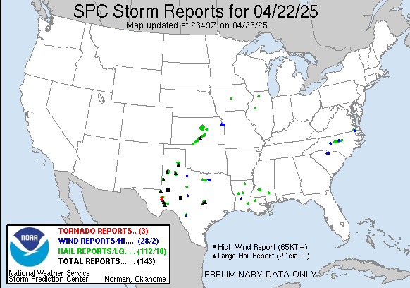
yesterday Reports Graphic

Tornado Reports (CSV) (Raw Tornado CSV)(?)
Time Location County State Lat Lon Comments
1956 NEWCASTLE MCCLAIN OK 3525 9760 LIFTED AROUND 336 PM. ESTIMATED PATH LENGTH OF 20 MILES THRU NEWCASTLE, MOORE, AND SOUTH OKC. PRELIMINARY DAMAGE RATING OF AT LEAST EF4. (OUN)
2056 3 S AVANT OSAGE OK 3645 9606 MULTIPLE SPOTTERS AND BROADCAST MEDIA REPORT A LARGE TORNADO ON THE GROUND THAT FIRST DEVELOPED NEAR AVANT AND CONTINUED NORTHEASTWARD INTO WASHINGTON COUNTY. A TORNADO (TSA)
2112 3 SW DEARING MONTGOMERY KS 3703 9574 BRIEF TOUCHDOWN ALONG HIGHWAY 166 NEAR COUNTY ROAD 3500. (ICT)
2130 1 W MEEKER LINCOLN OK 3550 9691 REPORTED BY KWTV (OUN)
2135 4 W TALALA ROGERS OK 3653 9577 REPORTED BY OKLAHOMA HIGHWAY PATROL (TSA)
2139 2 NE OWENS BROWN TX 3186 9891 TORNADO REPORTED BY HAM RADIO OPERATOR (SJT)
2205 5 SW MANTER STANTON KS 3747 10195 A LANDSPOUT TORNADO WAS REPORTED. ANOTHER PREVIOUS LANDSPOUT THAT OCCURRED AROUND 450PM HAD DISSIPATED. (DDC)
2205 1 S MANTER STANTON KS 3751 10188 A POSSIBLE LANDSPOUT TORNADO WAS REPORTED. ANOTHER PREVIOUS LANDSPOUT THAT OCCURRED AROUND 450PM HAD DISSIPATED. (DDC)
2210 5 SSE THE SAUNDERS ELEV STANTON KS 3740 10200 LANDSPOUT TORNADO REPORTED NEAR THE STATE LINE. (DDC)
2241 1 S RINGGOLD MONTAGUE TX 3381 9795 BRIEF TORNADO REPORTED 1 MILE SOUTH OF RINGGOLD. (FWD)
2245 BLANKET BROWN TX 3182 9879 DPS REPORTED A TORNADO ON THE GROUND IN THE COMMUNITY OF BLANKET. (SJT)
2253 10 NE MONTE VISTA ALAMOSA CO 3768 10601 BRIEF LANDSPOUT LASTED FOR ABOUT 5-6 MINUTES IN OPEN FIELD. (PUB)
2300 5 NNE ZEPHYR BROWN TX 3174 9876 TORNADO REPORTED AT RR-1467 AND CO-291 BY AMATEUR RADIO OPERATOR. (SJT)
2330 8 S QUAPAW OTTAWA OK 3684 9479 DAMAGE TO A DIESEL SHOP. NUMEROUS POWER POLES SNAPPED. SEMI TRAILERS BLOWN OFF THE ROAD. 50 TO 60 FOOT TREE ALSO BLOCKING A ROADWAY 3 MILES EAST OF TWIN BRIDGES LIKELY (TSA)
2336 3 E PROCTOR ADAIR OK 3597 9472 TORNADO REPORTED BY TRAINED SPOTTER AND COLOCATED WITH A STRONG RADAR CIRCULATION. TREES DOWN ON HIGHWAY 62. TORNADO MAY HAVE CONTINUED TO NEAR THE ILLINOIS RIVER BRIDG (TSA)
2349 2 N SILOAM SPRINGS BENTON AR 3622 9454 PHOTO OF A SMALL TORNADO RECEIVED. TREE DAMAGE WAS REPORTED IN THE AREA. TIME ESTIMATED VIA RADAR. (TSA)
0025 PRIDDY MILLS TX 3167 9852 S.O. REPORTS A TORNADO NEAR PRIDDY UPROOTED TREES. (FWD)
0029 HANNIBAL MARION MO 3971 9138 (LSX)
0032 HANNIBAL MARION MO 3971 9138 A SMALL HOLE IN THE ROOF AT THE HANNIBAL – LAGRANGE SCIENCE BUILDING WAS UNCOVERED AND NOT THE ENTIRE ROOF. (LSX)
0036 HANNIBAL MARION MO 3971 9138 THERE ARE SEVERAL LARGE TREES SNAPPED. – SEVERE DANAGE TO TWO MACHINE SHEDS NEAR HIGHWAY MM. SHINGLES REMOVED AT SOME BUILDINGS IN DOWNTOWN AREA. (LSX)
0132 5 WSW BOKOSHE LE FLORE OK 3516 9487 REPORT FROM LAW ENFORCEMENT RADIO OF A TORNADO BETWEEN MCCURTAIN AND BOKOSHE COLOCATED WITH A STRONG RADAR CIRCULATION. BROADCAST MEDIA REPORTED POWER FLASHES IN THE AR (TSA)
0150 CAMERON LE FLORE OK 3513 9453 LAW ENFORCEMENT RADIO REPORTED A TORNADO NEAR CAMERON COLOCATED WITH A STRONG RADAR CIRCULATION. IT MAY HAVE CONTINUED TO THE ROCK ISLAND VICINITY. EMERGENCY MANAGEMENT (TSA)

bookmark_borderSolar Radiation Storms

Solar radiation storms continue. It takes about two days for the effects to reach Earth.

A solar flare is a sudden brightening observed over the Sun’s surface or the solar limb, which is interpreted as a large energy release of up to 6 × 1025 joules of energy (about a sixth of the total energy output of the Sun each second or 160,000,000,000 megatons of TNT equivalen.) They are mainly followed by a colossal coronal mass ejection also known as a CME. The flare ejects clouds of electrons, ions, and atoms through the corona of the sun into space. These clouds typically reach Earth a day or two after the event.

X-rays and UV radiation emitted by solar flares can affect Earth’s ionosphere and disrupt long-range radio communications. Direct radio emission at decimetric wavelengths may disturb operation of radars and other devices operating at these frequencies.

The radiation risks posed by coronal mass ejections are a major concern in discussions of a manned mission to Mars, the moon, or other planets. Energetic protons can pass through the human body, causing biochemical damage,[10] presenting a hazard to astronauts during interplanetary travel. Some kind of physical or magnetic shielding would be required to protect the astronauts. Most proton storms take at least two hours from the time of visual detection to reach Earth’s orbit. A solar flare on January 20, 2005 released the highest concentration of protons ever directly measured,[11] giving astronauts as little as 15 minutes to reach shelter.

Region 1748 has been quiet but current analysis shows it still has the potential for more large events. SWPC forecasters are watching this region very carefully as it rotates further on the disk and into a more geoeffective position.

A CME, from the X1 flare on 15 May, is expected to arrive here late on 17 May but very little effects are forecast.

Solar Flare, May 15, 2013

bookmark_borderOh No Snow

BOZEMAN, Mont. – Warmer spring temperatures since 1980 are causing an estimated 20 percent loss of snow cover across the Rocky Mountains of western North America, according to new research from the U.S. Geological Survey.

The new study builds upon a previous USGS snowpack investigation which showed that, until the 1980s, the northern Rocky Mountains experienced large snowpacks when the central and southern Rockies experienced meager ones, and vice versa. Yet, since the 1980s, there have been simultaneous snowpack declines along the entire length of the Rocky Mountains, and unusually severe declines in the north.

The new study has teased apart and quantified the different influences of winter temperature, spring temperature, and precipitation on historic snowpack variations and trends in the region. To distinguish those varying influences, the researchers implemented a regional snow model that uses inputs of monthly temperature and precipitation data from 1895 to 2011.

“Each year we looked at temperature and precipitation variations and the amount of water contained within the snowpack as of April,” said USGS scientist Greg Pederson, the lead author of the study. “Snow deficits were consistent throughout the Rockies due to the lack of precipitation during the cool seasons during the 1930s – coinciding with the Dust Bowl era. From 1980 on, warmer spring temperatures melted snowpack throughout the Rockies early, regardless of winter precipitation. The model in turn shows temperature as the major driving factor in snowpack declines over the past thirty years.”

Runoff from Rocky Mountain winter snowpack accounts for 60 to 80 percent of the annual water supply for more than 70 million people living in the western U.S., and is influenced by factors such as the snowpack’s water content, known as snow water equivalent, and the timing of snowmelt.

The timing of snowmelt affects not only when water is available for crop irrigation and energy production from hydroelectric dams, but also the risk of regional floods and wildfires. Earlier and faster snowmelt could have repercussions for water supply, risk management, and ecosystem health in western watersheds.

Regional snowpack accumulation is highly sensitive to variations in both temperature and precipitation over time. Patterns and sources of these variations are difficult to discern due to complex mountain topography, the different influence of Pacific Ocean climate, like La Niña and El Niño, on winter precipitation in the northern versus southern and central Rockies, and the brevity and patchiness of detailed snow records.

In the study, the regional snow model used by Pederson and his USGS colleagues Julio Betancourt and Greg McCabe allows estimation of snow water and cover variability at different latitudes and elevations during the last century regardless of the absence of direct and long-term observations everywhere. Recent snowpack variations also were evaluated in the context of snowpack evidence from tree-rings, allowing the scientists to compare recent observations to measurements from the past 800 years.

McCabe, co-author of the study, explains that “recent springtime warming also reduced the extent of snow cover at low to middle elevations where temperature has had the greatest impact.”

“Both natural variability in temperature and anthropogenic warming have contributed to the recent snowpack decline, though disentangling their influences exactly remains elusive.” Betancourt said,

“Regardless of the ultimate causes, continuation of present snowpack trends in the Rocky Mountains will pose difficult challenges for watershed management and conventional water planning in the American West.”

The study, “Regional patterns and proximal causes of the recent snowpack decline in the Rocky Mountains,” is available from Geophysical Research Letters, a journal of the American Geophysical Union.

bookmark_borderCoastal Change: Hurricanes and Extreme Storm Hazards

Part of the Human Induced Climate Change Experiment

One of the goals of the USGS Coastal and Marine Geology Program is a national assessment of coastal change hazards. Hurricanes provide a powerful force that generates dangerous waves and currents capable of moving large amounts of sand, destroying buildings and infrastructure, and reshaping our nation’s coastline. Our research focuses on understanding the magnitude and variability of the impacts of hurricanes and extreme storms on the sandy beaches of the United States. The overall objective is to improve the capability to predict coastal change that results from severe storms. Such a capability will support management of coastal infrastructure, resources, and safety.

Hurricane Sandy Example

As Hurricane Sandy moved northward along the U.S. Atlantic coast in October 2012, U.S. Geological Survey scientists worked to determine where and how the storm’s waves and surge might dramatically reshape the beaches and dunes that stand between the storm and coastal developments. Through a complex modeling process that uses coastal elevations, wave forecasts, and potential storm surge, they predicted coastal change hazards, such as shoreline and dune erosion, that might be expected during a Sandy landfall.

Using the latest storm information available, USGS predicted the likelihood of a range of coastal change impacts within the region affected by the storm:

  • Dune erosion was very likely for the majority of the sandy beaches along the Maryland and Delaware coasts with widespread overwash also very likely in many areas.
  • Most of the New Jersey coast was very likely to experience extensive beach and dune erosion and many areas were very likely to overwash.
  • Along the south shore of Long Island, New York, the models predicted extensive beach and dune erosion as well as intermittent overwash.

Hurricane Sandy, the largest Atlantic hurricane on record, made landfall on October 30, 2012, and impacted a long swath of the Mid-Atlantic coastline. Many areas that had been hit by Hurricane Irene in August 2011 were again battered by strong waves and surge. The barrier islands were breached in a number of places and erosion of the beach and dunes occurred all along the Mid-Atlantic coast. This was the most destructive storm to impact this coastline since an extremely powerful nor’easter in December of 1992.

Following landfall, oblique aerial photography and lidar surveys of beach elevations were used to document the changes that occurred as a result of the storm. In addition, field measurements of the beaches and dunes were collected immediately after the storm. Comparisons of data collected before the storm show the nature, magnitude and spatial variability of the coastal response. These data will be used to further refine predictive models for storm-induced erosion.

Response Activities

Pre-landfall

Post-landfall (approx. 3-14 days)