bookmark_borderBig Bang Heard

Scientists in the USA believe they have discovered echoes from the Big Bang! A specialized telescope (called Bicep — Background Imaging of Cosmic Extragalactic Polarization) that is located at the South Pole has detected “primordial gravitational waves.”

“In physics, gravitational waves are ripples in the curvature of space/time that propagate as a wave, traveling outward from the source. Predicted in 1916 by Albert Einstein to exist on the basis of his theory of general relativity, gravitational waves theoretically transport energy as gravitational radiation,” according to Wikipedia.

“If they do announce primordial gravitational waves on Monday, I will take a huge amount of convincing,” said Hiranya Peiris, a cosmologist from University College London. “But if they do have a robust detection … Jesus, wow! I’ll be taking next week off.”

“It’s been called the Holy Grail of cosmology,” says Peiris, “It would be a real major, major, major discovery.”

bookmark_border4.4 Earthquake Shakes California

An earthquake registering 4.4 Magnitude shook Southern California on St. Patrick’s Day.

Time:
Location: 34.135°N 118.486°W (9km NNW of Westwood, California)
Depth: 9.9km

Nearby Cities

  1. 9km (6mi) NNW of Westwood, California
  2. 10km (6mi) NW of Beverly Hills, California
  3. 12km (7mi) W of Universal City, California
  4. 12km (7mi) N of Santa Monica, California
  5. 562km (349mi) SSE of Sacramento, California
4.4 California Earthquake

The LA Times reported:
Robert Graves, a seismologist with the U.S. Geological Survey, told reporters that Monday’s earthquake was the most significant shake in this Southern California area since the magnitude 5.5 earthquake in Chino Hills in 2008.

The region where the fault hit has not been seismically active recently, Graves said.

“The location is somewhat surprising. It’s within the Santa Monica Mountains. We have not seen seismicity in it in recent times,” said Caltech seismologist Egill Hauksson.

L.A. Mayor Eric Garcetti confirmed the city had no reports of damage.

“Today’s earthquake is a reminder that every L.A. family must be prepared with food, water and other essentials, as well as a plan,” the mayor said in a statement.

bookmark_borderNews from the Ice Wars

The Membrane Domain has been conducting Human Induced Climate Change Experiments since 1999. One of the first scientist to hypothesize that global warming was exponential (as opposed to the linear models) requested fellow scientists to conduct studies.

One Membrane Domain scientists began a study on the decline of the ice mass. The analysis is on-going; however, recent data leads to the conclusion that the process is exponential:

The two largest ice sheets on earth, Greenland and Antarctica, are losing mass faster and faster. The figure below is from Velicogna and Wahr, “Time-variable gravity observations of ice sheet mass balance: Precision and limitations of the GRACE satellite data” GEOPHYSICAL RESEARCH LETTERS, VOL. 40, 3055-3063, doi:10.1002/grl.50527, 2013

Mass loss for Greenland and  Antarctica from 2003-2013

For reference, 360 GTonne of mass loss results in 1 mm sea level rise. Greenland lost more than that in 2012 alone.

Causes of Mass Loss

I. Marine terminated glaciers flow to the ocean and calve off icebergs. The figure below is from Rignot and Mouginot,”Ice flow in Greenland for the International Polar Year 2008-2009,” GEOPHYSICAL RESEARCH LETTERS, VOL. 39, L11501, doi:10.1029/2012GL051634, 2012

Read More on the Decline of the Ice Mass

bookmark_borderIf the Ice were Gone

The Membrane Domain has been conducting Human Induced Climate Change Experiments since 1999. One of the first scientist to hypothesize that global warming was exponential (as opposed to the linear models) requested fellow scientists to conduct studies.

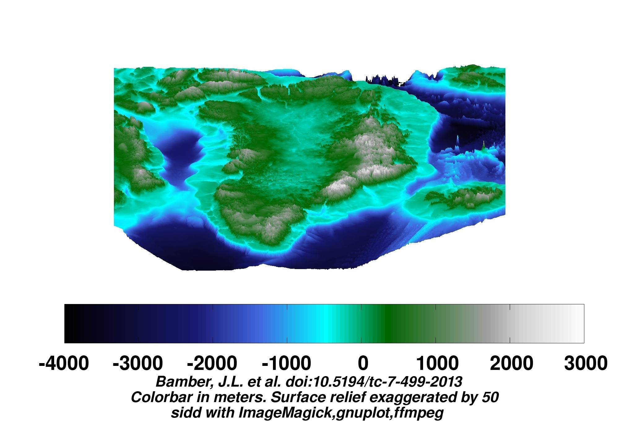
Another of the Membrane Domain scientists began a study on the ice mass of Greenland. The analysis is on-going; however, recent data leads to the conclusion that the process is exponential:

A new map of Greenland has been made.

For ice surface views, go here. For dual ice surface and bedrock views, go here. The images below are links to larger versions. Click on the image to view the larger version.

Some bedrock views follow. No isostatic rebound included. (When the ice melts, the earth beneath will rise as she is unburdened. This effect is not included in the depictions here.)

45 degree projection looking toward the four cardinal points:

View of Greenland


More of “If the Ice were Gone”

More on Global Warming

bookmark_borderFatwa Against Going to Mars

Muslim leaders issue a fatwa against going to Mars. A fatwā is part of the Islamic faith and is the term for the legal judgment pertaining to the Islamic law. The ruling was made after several names of known Muslims appeared on a list of people scheduled to go to Mars in 2024.

According to the Daily Mail:

A Fatwa has been issued against living on Mars by clerics who say that trying to set up home there would be un-Islamic.

The fatwa – or ruling – was issued by the General Authority of Islamic Affairs and Endowment (GAIAE) in the UAE after the Mars One organisation announced that it would try and establish a permanent human settlement on Mars.

The committee argued that an attempt to dwell on the planet would be so hazardous as to be suicidal and killing oneself is not permitted by Islam.

bookmark_borderExtreme Weather Events and the Meandering Jet Stream

The extreme weather events effecting the USA, England and Australia by be a result of a change in the Jetstream. The BBC reports:

New research suggests that the main system that helps determine the weather over Northern Europe and North America may be changing.

The study shows that the so-called jet stream has increasingly taken a longer, meandering path.

This has resulted in weather remaining the same for more prolonged periods.

The work was presented at the annual meeting of the American Association for the Advancement of Science (AAAS) in Chicago.

The observation could be as a result of the recent warming of the Arctic. Temperatures there have been rising two to three times faster than the rest of the globe.

According to Prof Jennifer Francis of Rutgers University in New Jersey: “This does seem to suggest that weather patterns are changing and people are noticing that the weather in their area is not what it used to be.”

The meandering jet stream has accounted for the recent stormy weather over the UK and the bitter winter weather in the US Mid-West remaining longer than it otherwise would have.

“We can expect more of the same and we can expect it to happen more frequently,” says Prof Francis

bookmark_borderExtreme Weather Hits U.S., England and Australia

The United States, England and Australia are all experiencing severe and extreme weather events. In the United States, the East and Southeast have been hit with all types of winter storms. On the West Coast, the drought has reached critical stages of water conservation, as well as, causing wildfires. England is getting hit with the worst precipitation and flooding in the last 250 years. Australia is getting record temperature heat waves while other parts are underwater from deluges.

“Fire crews spend the day battling fires in South Australia and Victoria as the southern states endure a weekend of extreme weather conditions.” “The weather records keep tumbling in Adelaide – this time due to heavy rainfall. “– Australian Broadcasting Corporation

“Thousands of sandbags are being piled up to protect homes and businesses as more heavy rain and gale-force winds sweep across southern Britain.” — British Broadcasting Corporation

“Global Warming — We are not saying that the Earth’s temperature is just going to rise. In general, as energy is added to a system, the fluctuations in the system increase. So, we expect more storms, more droughts, more wildfires, more floods, more fluctuations of all kinds. What we are saying is that weather conditions will become more volatile due to the impact of humans.” — S. Mukherjee & D. Brouse (2004)

More On Global Warming

bookmark_border4.1 Earthquake Hits South Carolina

Event Time
2014-02-15 03:23:38 UTC
2014-02-14 22:23:38 UTC-05:00 at epicenter
2014-02-14 22:23:38 UTC-05:00 system time

Location — 33.812°N 82.063°W depth=4.9km (3.0mi)

Nearby Cities
12km (7mi) WNW of Edgefield, South Carolina
31km (19mi) NNE of Evans, Georgia
32km (20mi) N of Martinez, Georgia
35km (22mi) NNW of North Augusta, South Carolina
97km (60mi) WSW of Columbia, South Carolina

Earthquakes in the Inland Carolinas Region

Since at least 1776, people living inland in North and South Carolina, and in adjacent parts of Georgia and Tennessee, have felt small earthquakes and suffered damage from infrequent larger ones. The largest earthquake in the area (magnitude 5.1) occurred in 1916. Moderately damaging earthquakes strike the inland Carolinas every few decades, and smaller earthquakes are felt about once each year or two.

Earthquakes in the central and eastern U.S., although less frequent than in the western U.S., are typically felt over a much broader region. East of the Rockies, an earthquake can be felt over an area as much as ten times larger than a similar magnitude earthquake on the west coast. A magnitude 4.0 eastern U.S. earthquake typically can be felt at many places as far as 100 km (60 mi) from where it occurred, and it infrequently causes damage near its source. A magnitude 5.5 eastern U.S. earthquake usually can be felt as far as 500 km (300 mi) from where it occurred, and sometimes causes damage as far away as 40 km (25 mi).

Faults

Earthquakes everywhere occur on faults within bedrock, usually miles deep. Most bedrock beneath the inland Carolinas was assembled as continents collided to form a supercontinent about 500-300 million years ago, raising the Appalachian Mountains. Most of the rest of the bedrock formed when the supercontinent rifted apart about 200 million years ago to form what are now the northeastern U.S., the Atlantic Ocean, and Europe.

At well-studied plate boundaries like the San Andreas fault system in California, often scientists can determine the name of the specific fault that is responsible for an earthquake. In contrast, east of the Rocky Mountains this is rarely the case. The inland Carolinas region is far from the nearest plate boundaries, which are in the center of the Atlantic Ocean and in the Caribbean Sea. The region is laced with known faults but numerous smaller or deeply buried faults remain undetected. Even the known faults are poorly located at earthquake depths. Accordingly, few, if any, earthquakes in the inland Carolinas can be linked to named faults. It is difficult to determine if a known fault is still active and could slip and cause an earthquake. As in most other areas east of the Rockies, the best guide to earthquake hazards in the seismic zone is the earthquakes themselves.

bookmark_borderJava Eruption

JAVA — “Based on verified data, over 76,000 people have been evacuated from five cities around the volcano … and about 200,000 people were affected,” National Disaster Mitigation Agency spokesman Sutopo Nugroho said.

The ash has interrupted air travel in the entire region. Fist-size rocks spewed down on rooftops. The largest problem is supplying masks so residents can breathe.