If you purchase real estate in a flood plain and obtain a mortgage, you will be required to purchase flood insurance.
Roy Wright oversees the Federal Emergency Management Agency’s (FEMA) National Flood Insurance Program. In a presentation to the Insurance-& Risk-Linked Securities Conference, Wright said to forget about checking the flood plain maps and check your drivers license. “If it says Florida, you need flood insurance.” FEMA is examining properties on coasts and in flood plains that have been repeatedly rebuilt “that we probably shouldn’t be providing coverage on.”
The national flood insurance program is now $20 billion in debt, largely because of Irma and other catastrophic storms like Harvey. Wright, during a break in the insurance conference, sat down with the Miami Herald to outline a plan to stabilize a troubled federal program vital to Florida’s real estate industry. It includes ambitious goals to double enrollment over the next five years amid a major makeover that will include more aggressive purchases of re-insurance and catastrophe bonds.
By law, only homes with federally-backed mortgages in high-risk zones are required to have insurance.
The National Flood Insurance Program provides nearly three times the number of policies in Florida as any other state.
National Flood Insurance Program
In the lead-up to Irma, an Associated Press analysis found that the number of Florida homes covered in high-risk areas had dropped by 15 percent in the previous five years. Fewer than half in hazard zones were protected from flood damage.
Wright blamed the problem partly on flood maps that, like hurricane tracking maps, can mislead homeowners on actual risks.
“We really gotta help people move beyond and quit focusing just on the lines,” he said. “Because nature, the day it rains, pays no attention to the lines.”
By contrast, when Harvey slammed the Texas coast, the national flood program insured 70 percent of the homes in moderate flood zones in Harris County. After the storm passed, 60 percent of the claims came from those moderate zones, proof that storms don’t always follow the contours of a flood map, Wright said.
“That’s true in areas of Florida as well,” he said.
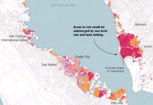
The report indicates that the sinking land (called land subsidence) will increase the reach and damage of flooding in the Bay Area. The impact will be more dramatic than predicted in the forecasts for 2100.
“It’s a very well-known problem, but we really don’t know how fast it’s going to be in the second half of the 21st century. This is a projection,” Dr. Shirzaei said.
San Fransisco Bay Circa 2100
Abstract
by Manoochehr Shirzaei and Roland Bürgmann
The current global projections of future sea level rise are the basis for developing inundation hazard maps. However, contributions from spatially variable coastal subsidence have generally not been considered in these projections. We use synthetic aperture radar interferometric measurements and global navigation satellite system data to show subsidence rates of less than 2 mm/year along most of the coastal areas along San Francisco Bay. However, rates exceed 10 mm/year in some areas underlain by compacting artificial landfill and Holocene mud deposits. The maps estimating 100-year inundation hazards solely based on the projection of sea level rise from various emission scenarios underestimate the area at risk of flooding by 3.7 to 90.9%, compared with revised maps that account for the contribution of local land subsidence. Given ongoing land subsidence, we project that an area of 125 to 429 km2 will be vulnerable to inundation, as opposed to 51 to 413 km2 considering sea level rise alone.
The flood risks across the whole USA are seriously underestimated
The following paper covers all flood risk, not just the coasts, but inland and all the causes including sea level rise as well as flooding rivers and large precipitation events outside watersheds.
“Estimates of present and future flood risk in the conterminous United States”
Oliver E J Wing , Paul D Bates, Andrew M Smith, Christopher C Sampson, Kris A Johnson, Joseph Fargione and Philip Morefield
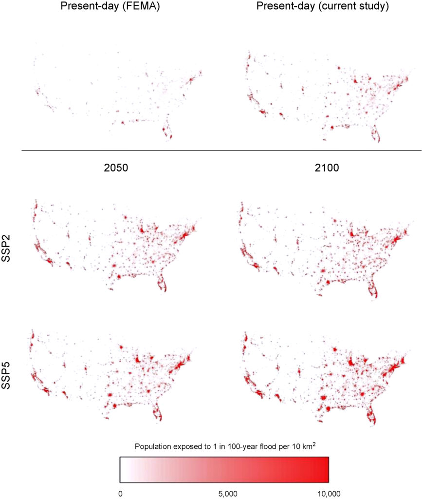
Wing et al. analyze flood risk in the US lower 48. Apparently 41 million are at risk rather than 13 million in current FEMA estimates.
WARNING: this paper specifically does not cover sea levels rise and increased precipitation.
“Our data show that the total US population exposed to serious flooding is 2.6–3.1 times higher than previous estimates, and that nearly 41 million Americans live within the 1% annual exceedance probability floodplain (compared to only 13 million when calculated using FEMA flood maps)”
“The analysis shows that 40.8 million people (13.3% of the population) are currently exposed to a 1 in 100 year (1% annual exceedance probability) fluvial or pluvial flood in the CONUS, which translates to a GDP exposure of $2.9 trillion (15.3% of total GDP)”
“This analysis indicates that previous estimates capture roughly one-third of the exposure identified in our 1 in 100 year floodplain.”
“It doesn’t take into account sea level rise and heavier rainfall expected to come along with climate change, so it likely underestimates the exposure, the authors warned.”
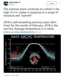
The North Pole saw record high temperatures for February during 2018.
Record Temperature at North Pole
Reuters reported:
Temperatures may have soared as high as 35 degrees Fahrenheit (2 degrees Celsius) at the pole, according to the U.S. Global Forecast System model. While there are no direct measurements of temperature there, Zack Labe, a climate scientist working on his PhD at the University of California at Irvine, confirmed that several independent analyses showed “it was very close to freezing,” which is more than 50 degrees (30 degrees Celsius) above normal.
The warm intrusion penetrated right through the heart of the Central Arctic, Labe said. The temperature averaged for the entire region north of 80 degrees latitude spiked to its highest level ever recorded in February. The average temperature was more than 36 degrees (20 degrees Celsius) above normal. “No other warm intrusions were very close to this,” Labe said in an interview, describing a data set maintained by the Danish Meteorological Institute that dates back to 1958. “I was taken by surprise how expansive this warm intrusion was.”
Climate scientist Sidd Mukherjee added, “Yes. Even more scarily — the fast ice north of Greenland is gone. That was some of the oldest ice left. It hasn’t melted, just been blown away and drifted away with the currents.” (see “Talk about unprecedented“)
An article in Rolling Stone about climate migrations quotes Solomon Hsiang:
Hsiang has many good papers outAn article in Rolling Stone about climate migrations quotes Solomon Hsiang:
“Most people don’t realize how much climate affects everything, from their property values to how hard people work,” says Solomon Hsiang, a professor of public policy at the University of California, Berkeley, who led a recent study that predicts, as the climate warms, there will be “a large transfer of value northward and westward.” And the wealthy, who can afford to adapt, will benefit, while the poor, who will likely be left behind, will suffer. “If we continue on the current path,” Hsiang says, “our analysis suggests that climate change may result in the largest transfer of wealth from the poor to the rich in the country’s history.”
Dr. Mukherjee replied, “But for city officials in at-risk cities, homeowners like Brown are terrifying. “Once people start thinking about the long-term value of their homes and how they will be impacted by climate change, that changes the game completely,” a county attorney in Florida says. What happens to the value of a house in, for instance, Fort Lauderdale, when the cost of flood insurance triples? “When I think about the future of South Florida, it’s flood insurance that scares me the most,” Wayne Pathman, a prominent Miami lawyer and board member of Miami Beach’s chamber of commerce, tells me. Many officials fear a climate-driven exodus that pushes down property values, which in turn reduces property-tax revenues, which are central to funding city services like police and teachers, not to mention road repair and infrastructure maintenance, at precisely the moment when the city needs to spend more to adapt to climate change.
Flooding in downtown Miami after Hurricane Irma in September 2017. Kadir van Lohuizen/NOOR/Redux
It’s a downward spiral for real estate that’s very hard to reverse. “It’s just like the dynamic in the stock market,” says U.C. Berkeley’s Hsiang. “The longer you hold on, the more you have to lose.” And, in many cases, the regions of the country where climate-change denial is strongest, such as the Southeast, are exactly the regions where residents have the most to lose. “In many places, climate denial is going to turn out to have big economic consequences,” Hsiang says.
[Hsiang has many good papers out]
“The [Federal Open Market Committee] will continue to strike a balance between avoiding an overheating economy and bringing … price inflation to 2 percent on a sustained basis,” Chairman Jerome H. Powell said Congress as Fed chair.
The new Chairman of the Federal Reserve made his first testimony to Congress:
The Congress has assigned us the goals of promoting maximum employment and stable prices. Over the second half of 2017, the FOMC continued to gradually reduce monetary policy accommodation. Specifically, we raised the target range for the federal funds rate by 1/4 percentage point at our December meeting, bringing the target to a range of 1-1/4 to 1-1/2 percent. In addition, in October we initiated a balance sheet normalization program to gradually reduce the Federal Reserve’s securities holdings. That program has been proceeding smoothly. These interest rate and balance sheet actions reflect the Committee’s view that gradually reducing monetary policy accommodation will sustain a strong labor market while fostering a return of inflation to 2 percent.
n gauging the appropriate path for monetary policy over the next few years, the FOMC will continue to strike a balance between avoiding an overheated economy and bringing PCE price inflation to 2 percent on a sustained basis. While many factors shape the economic outlook, some of the headwinds the U.S. economy faced in previous years have turned into tailwinds: In particular, fiscal policy has become more stimulative and foreign demand for U.S. exports is on a firmer trajectory. Despite the recent volatility, financial conditions remain accommodative. At the same time, inflation remains below our 2 percent longer-run objective. In the FOMC’s view, further gradual increases in the federal funds rate will best promote attainment of both of our objectives. As always, the path of monetary policy will depend on the economic outlook as informed by incoming data.
In a recent study by Matthias Mengel, Alexander Nauels, Joeri Rogelj & Carl-Friedrich Schleussner entitled “Committed sea-level rise under the Paris Agreement and the legacy of delayed mitigation action” published in the Journal Nature, the authors contend — sea levels will rise between 0.7 and 1.2 meters (27-47 inches) in the next two centuries even if governments end the fossil fuel era as committed to under the Paris climate agreement.
THE ABSTRACT
Sea-level rise is a major consequence of climate change that will continue long after emissions of greenhouse gases have stopped. The 2015 Paris Agreement aims at reducing climate-related risks by reducing greenhouse gas emissions to net zero and limiting global-mean temperature increase. Here we quantify the effect of these constraints on global sea-level rise until 2300, including Antarctic ice-sheet instabilities. We estimate median sea-level rise between 0.7 and 1.2 m, if net-zero greenhouse gas emissions are sustained until 2300, varying with the pathway of emissions during this century. Temperature stabilization below 2 °C is insufficient to hold median sea-level rise until 2300 below 1.5 m. We find that each 5-year delay in near-term peaking of CO2 emissions increases median year 2300 sea-level rise estimates by ca. 0.2 m, and extreme sea-level rise estimates at the 95th percentile by up to 1 m. Our results underline the importance of near-term mitigation action for limiting long-term sea-level rise risks.
A 3-foot rise in sea level would put much of the United States’ East Coast, Florida and New Orleans underwater.
In 2006 and 2007, we forecast the impending “great recession”. Our investment advice was to sell all your real estate. If you could not sell it, leverage it to the hilt (so you had your cash out before failure.)
Turned out to be an accurate forecast.
In 2017 and 2018, we are forecasting inflation and rising interest rates. Buy real estate now and lock-in your 30-year interest rates ASAP. [WARNING: Do not buy real estate on or near floodplain. See disclaimer below.] [WARNING: This paper was first published in 2018. Since that time the forecast has reached fruition. It is too late to beat rising interest rates.]
WHY?
* Quantitative Easing and the Troubled Asset Relief Program (TARP) was started during the height of the 2008 financial crisis. In essence, it allowed the Treasury to print money.
* In 2017 Donald Trump started enacting policies that mirrored his personal finances — borrow too much money and don’t plan on paying it back. Mr. Trump has been involved in 6 bankruptcies.
* When the government borrows lots of money without a payback plan, they compete with the private sector to borrow money resulting in a rise in interest rates. This phenomena is known as crowding out (economics). (1)
* President Trump bragged about wage inflation during his State Of The Union (SOTU) address. When wages go up without an increase in productivity, the prices of goods and services inflate.(2)
* “Make America Great Again” policies make the American dollar weak. Tariffs and trade protectionism undermine the value of the dollar and contribute to inflation. (3)
* President Trump replaced the Chairwoman of the Federal Reserve with a new chair who is not an economist. A first in U.S. history.
* Tax cuts without spending cuts result in a budget deficit. The nation’s debt is now bigger than its gross domestic product. Net interest payments on the debt are estimated to total $276.2 billion this fiscal year, or 6.8% of all federal outlays. The tax cuts are expected to make this payment explode.
* The Federal Reserves primary weapon for fighting inflation is to raise interest rates. (4)
You could say inflation and rising interest rates are a two-headed monster. When the government creates money, it is “inflationary.” The government fights inflation by raising interest rates. Rising interest rates exponentially increase the national debt. When the government borrows, it competes with consumer borrowing causing interest rates to rise.
The name given to the worst-case scenario is hyper-inflation. We don’t expect hyperinflation in the US in the near future; however, higher interest rates in the US will result in hyperinflation in other parts of the world. (See Part III below.)
WARNING: Do not buy real estate on or near floodplain.
Do not invest in real estate that is located near floodplain. Make sure your property has land ingress and egress from the closest 1,000-year-floodplain. Do not invest in any property located near a coast. Do not invest in a property that is below sea level. Do not invest in real estate located in Florida.
“Mostly stay away from the coasts because of both wind and rain issues from weather systems spinning inland. Even if you are not in a floodplain, a couple feet of rain in a day will cut off roads and overwhelm your sump pumps. Not to speak of wind taking power and telecom down.” — Sidd Mukerhjee (February 5, 2018)
NOTES
(1) “In economics, crowding out is argued by some economists to be a phenomenon that occurs when increased government involvement in a sector of the market economy substantially affects the remainder of the market, either on the supply or demand side of the market.
One type frequently discussed is when expansionary fiscal policy reduces investment spending by the private sector. The Government is “crowding out” investment because it is demanding more Loanable Funds and it is increasing interest rates from the borrowing, but that was broadened to multiple channels that might leave total output little changed or smaller.” — Olivier Jean Blanchard (2008) “crowding out,” The New Palgrave Dictionary of Economics, 2nd Edition. Abstract and Roger W. Spencer & William P. Yohe, 1970. “The ‘Crowding Out’ of Private Expenditures by Fiscal Policy Actions,” Federal Reserve Bank of St. Louis Review, October, pp. 12-24
(2) “After years of wage stagnation, we are finally seeing rising wages,” Donald Trump (State of the Union 2018)
“The Employment Cost Index, a measure of salary and benefit costs, registered a 2.6 percent gain for the full year, tied for the best since 2007.” — CNBC (January 31, 2018)
(3) “Recently, Trump levied steep tariffs on imported solar panel technology and washing machines, which immediately boosted prices for U.S. consumers.” — The Hill (February 6, 2018)
(4) “Federal Reserve officials followed through on an expected interest-rate increase and raised their forecast for economic growth in 2018, even as they stuck with a projection for three (rate) hikes in the coming year.
“This change highlights that the committee expects the labor market to remain strong, with sustained job creation, ample opportunities for workers and rising wages,” Chair Janet Yellen told reporters Wednesday in Washington following the decision. In her final scheduled press conference, Yellen noted that her nominated successor, Jerome Powell, has been part of the consensus shaping the Fed’s gradual rate-hike strategy.” — “Fed Raises Rates, Eyes Three 2018 Hikes as Yellen Era Nears End” (December 13, 2017)
Part II: Inflation Bites
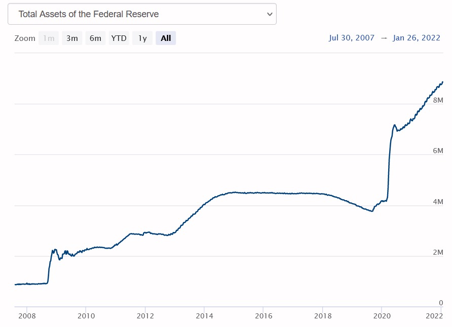
In March of 2020, the global pandemic put the Fed on hold. Then, the Fed reversed course, did not increase rates, and did substantially more (trillions) quantitative easing (see chart below.) In addition, the federal government borrowed trillions of dollars with no repayment plan. A large portion of this money was given to consumers as stimulus. The consumers shifted the demand curve causing a sharp rise in prices. “A demand curve shift refers to fundamental changes in the balance of supply and demand that alter the quantity demanded at the same price,” says The Balance Economic Theory. Consumers continued to spend beyond their means raising consumer debt. “Household debt in the third quarter of 2022, increasing by $351 billion (2.2%) to $16.51 trillion. Balances now stand $2.36 trillion higher than at the end of 2019, before the pandemic recession,” as reported by the Federal Reserve Bank of New York.
UPDATE: January 30, 2022
Inflation has hit 7% — the highest rate in 40 years.
The Fed has signaled that they are:
1) stopping quantitative easing in March
2) raising interest rates in March
Stopping quantitative easing means the Fed will no longer be supporting low Treasury yields by buying bonds. To date, they have bought over 8 trillion in Treasuries and other instruments that undercut interest rates. When the Fed stops buying Treasuries, the demand will go down and rates will go up.
Federal Reserve Balance Sheet 2022
The market has increased their forecast on the Fed raising rates to 4-5 times in 2022. When the Fed raises rates that banks charge each other, the banks charge you higher interest rates.
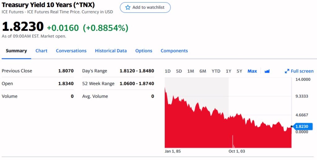
The 10 Year Treasury Note is the best indicator to watch for mortgage interest rates. It will reflect both the ending of quantitative easing and the increase in Fed funds rates. That is to say, if the Fed raises rates 1/4%, mortgage interest rates will likely rise 1/2%. That changes the forecast for mortgage rates in 2022 to rise 2 to 2.5%.
Borrow any long term money today before it is too late. [WARNING: This paper was first published in 2018. Since that time the forecast has reached fruition. It is too late to beat rising interest rates.] After rates rise for the next several years, there will be a recession. So, a long time before you may see conditions like we’ve had for the last 14 years.
10 Year Treasury Notes Interest Rates
Part III: U.S. Mass Consumption Results in Global Economic Disparity, Inequity, and Poverty
In Part I we mention the worst-case inflation scenario is hyper-inflation. We don’t expect hyperinflation in the US in the near future; however, higher interest rates in the US will result in hyperinflation in other parts of the world.
As long as the US Dollar is the world’s reserve currency, it is unlikely that the US will see hyperinflation. The US Congress defines the world’s reserve currency as, “a currency held by central banks in significant quantities. It is widely used to conduct international trade and financial transactions, eliminating the costs of settling transactions involving different currencies.”
When there is inflation in the US, the US Federal Reserve Bank raises interest rates. The rise in US interest rates results in other countries’ investors putting their money in dollar denominated US interest bearing investments. That is to say, foreign investors buy dollars with their home currencies. The result is a widened disparity in the exchange rates between the currencies. The US dollar increases in value and the foreign currency depreciates in value. There is a benefit to the US consumer — imported goods and services are cheaper. The disadvantage to the foreign countries is the dollar disparity causes a much greater rise in their domestic inflation as all their imports experience both the local inflation rate as well the inflation in buying dollars. In an even worse case scenario, the foreign country has debt that has to be repaid in dollars. In essence, their debt is multiplied by a factor equal to the decline in the value of their currency.
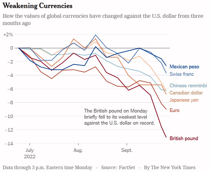
In September of 2022, the New York Times reported, “The Federal Reserve’s determination to crush inflation at home by raising interest rates is inflicting profound pain in other countries — pushing up prices, ballooning the size of debt payments and increasing the risk of a deep recession”
“Those interest rate increases are pumping up the value of the dollar — the go-to currency for much of the world’s trade and transactions — and causing economic turmoil in both rich and poor nations. In Britain and across much of the European continent, the dollar’s acceleration is helping feed stinging inflation.”
Weakening Currencies
Also in September of 2022, the Nikkei Asia reported, “Superstrong dollar threatens debt crisis across emerging economies. Mexico pressured to follow Fed hikes, while Sri Lanka’s repayment costs soar.”
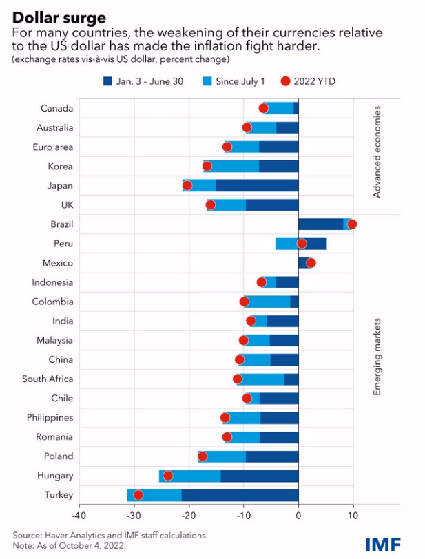
In October of 2022, the IMF reported, “The dollar is at its highest level since 2000, having appreciated 22 percent against the yen, 13 percent against the Euro and 6 percent against emerging market currencies since the start of this year. Such a sharp strengthening of the dollar in a matter of months has sizable macroeconomic implications for almost all countries, given the dominance of the dollar in international trade and finance.”
Dollar Surge
Conclusion
The United States has unsustainable mass consumption. US consumers are destroying the world’s environment and economies. The excessive demand of US consumers has resulted in the exploitation of natural resources, the largest emissions of pollution and greenhouse gases, inflation, currency disparity, and the largest redistribution of wealth in the world. Americans’ mass consumption is responsible for creating the greatest income disparity, wealth inequity, and poverty.
The report is an authoritative assessment of the science of climate change, with a focus on the United States. It represents the first of two volumes of the Fourth National Climate Assessment, mandated by the Global Change Research Act of 1990.
The report’s summary states:
Global annually averaged surface air temperature has increased by about 1.8°F (1.0°C) over the last 115 years (1901–2016). This period is now the warmest in the history of modern civilization. The last few years have also seen record-breaking, climate-related weather extremes, and the last three years have been the warmest years on record for the globe. These trends are expected to continue over climate timescales.This assessment concludes, based on extensive evidence, that it is extremely likely that human activities, especially emissions of greenhouse gases, are the dominant cause of the observed warming since the mid-20th century. For the warming over the last century, there is no convincing alternative explanation supported by the extent of the observational evidence.In addition to warming, many other aspects of global climate are changing, primarily in response to human activities. Thousands of studies conducted by researchers around the world have documented changes in surface, atmospheric, and oceanic temperatures; melting glaciers; diminishing snow cover; shrinking sea ice; rising sea levels; ocean acidification; and increasing atmospheric water vapor.
For example, global average sea level has risen by about 7–8 inches since 1900, with almost half (about 3 inches) of that rise occurring since 1993. Human-caused climate change has made a substantial contribution to this rise since 1900, contributing to a rate of rise that is greater than during any preceding century in at least 2,800 years. Global sea level rise has already affected the United States; the incidence of daily tidal flooding is accelerating in more than 25 Atlantic and Gulf Coast cities.
Global average sea levels are expected to continue to rise—by at least several inches in the next 15 years and by 1–4 feet by 2100. A rise of as much as 8 feet by 2100 cannot be ruled out. Sea level rise will be higher than the global average on the East and Gulf Coasts of the United States.
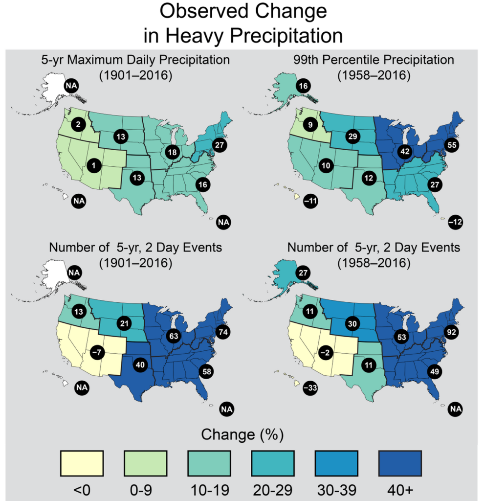
Changes in the characteristics of extreme events are particularly important for human safety, infrastructure, agriculture, water quality and quantity, and natural ecosystems. Heavy rainfall is increasing in intensity and frequency across the United States and globally and is expected to continue to increase. The largest observed changes in the United States have occurred in the Northeast.
Heatwaves have become more frequent in the United States since the 1960s, while extreme cold temperatures and cold waves are less frequent. Recent record-setting hot years are projected to become common in the near future for the United States, as annual average temperatures continue to rise. Annual average temperature over the contiguous United States has increased by 1.8°F (1.0°C) for the period 1901–2016; over the next few decades (2021–2050), annual average temperatures are expected to rise by about 2.5°F for the United States, relative to the recent past (average from 1976–2005), under all plausible future climate scenarios.
The incidence of large forest fires in the western United States and Alaska has increased since the early 1980s and is projected to further increase in those regions as the climate changes, with profound changes to regional ecosystems.
Annual trends toward earlier spring melt and reduced snowpack are already affecting water resources in the western United States and these trends are expected to continue. Under higher scenarios, and assuming no change to current water resources management, chronic, long-duration hydrological drought is increasingly possible before the end of this century.
The magnitude of climate change beyond the next few decades will depend primarily on the amount of greenhouse gases (especially carbon dioxide) emitted globally. Without major reductions in emissions, the increase in annual average global temperature relative to preindustrial times could reach 9°F (5°C) or more by the end of this century. With significant reductions in emissions, the increase in annual average global temperature could be limited to 3.6°F (2°C) or less.
The global atmospheric carbon dioxide (CO2) concentration has now passed 400 parts per million (ppm), a level that last occurred about 3 million years ago, when both global average temperature and sea level were significantly higher than today. Continued growth in CO2 emissions over this century and beyond would lead to an atmospheric concentration not experienced in tens to hundreds of millions of years. There is broad consensus that the further and the faster the Earth system is pushed towards warming, the greater the risk of unanticipated changes and impacts, some of which are potentially large and irreversible.
The observed increase in carbon emissions over the past 15–20 years has been consistent with higher emissions pathways. In 2014 and 2015, emission growth rates slowed as economic growth became less carbon-intensive. Even if this slowing trend continues, however, it is not yet at a rate that would limit global average temperature change to well below 3.6°F (2°C) above preindustrial levels.
Introduction
New observations and new research have increased our understanding of past, current, and future climate change since the Third U.S. National Climate Assessment (NCA3) was published in May 2014. This Climate Science Special Report (CSSR) is designed to capture that new information and build on the existing body of science in order to summarize the current state of knowledge and provide the scientific foundation for the Fourth National Climate Assessment (NCA4).
Since NCA3, stronger evidence has emerged for continuing, rapid, human-caused warming of the global atmosphere and ocean. This report concludes that “it is extremely likely that human influence has been the dominant cause of the observed warming since the mid-20th century. For the warming over the last century, there is no convincing alternative explanation supported by the extent of the observational evidence.”
The last few years have also seen record-breaking, climate-related weather extremes, the three warmest years on record for the globe, and continued decline in arctic sea ice. These trends are expected to continue in the future over climate (multidecadal) timescales. Significant advances have also been made in our understanding of extreme weather events and how they relate to increasing global temperatures and associated climate changes. Since 1980, the cost of extreme events for the United States has exceeded $1.1 trillion; therefore, better understanding of the frequency and severity of these events in the context of a changing climate is warranted.
Periodically taking stock of the current state of knowledge about climate change and putting new weather extremes, changes in sea ice, increases in ocean temperatures, and ocean acidification into context ensures that rigorous, scientifically-based information is available to inform dialogue and decisions at every level. This climate science report serves as the climate science foundation of the NCA4 and is generally intended for those who have a technical background in climate science. In this Executive Summary, green boxes present highlights of the main report. These are followed by related points and selected figures providing more scientific details. The summary material on each topic presents the most salient points of chapter findings and therefore represents only a subset of the report’s content. For more details, the reader is referred to the individual chapters. This report discusses climate trends and findings at several scales: global, nationwide for the United States, and for ten specific U.S. regions (shown in Figure 1 in the Guide to the Report). A statement of scientific confidence also follows each point in the Executive Summary. The confidence scale is described in the Guide to the Report. At the end of the Executive Summary and in Chapter 1: Our Globally Changing Climate, there is also a summary box highlighting the most notable advances and topics since NCA3 and since the 2013 Intergovernmental Panel on Climate Change (IPCC) Fifth Assessment Report.
Global and U.S. Temperatures Continue to Rise
Long-term temperature observations are among the most consistent and widespread evidence of a warming planet. Temperature (and, above all, its local averages and extremes) affects agricultural productivity, energy use, human health, water resources, infrastructure, natural ecosystems, and many other essential aspects of society and the natural environment. Recent data add to the weight of evidence for rapid global-scale warming, the dominance of human causes, and the expected continuation of increasing temperatures, including more record-setting extremes. (Ch. 1)
Changes in Observed and Projected Global Temperature
Global annual average temperature (as calculated from instrumental records over both land and oceans) has increased by more than 1.2°F (0.65°C) for the period 1986–2016 relative to 1901–1960; the linear regression change over the entire period from 1901–2016 is 1.8°F (1.0°C) (very high confidence; Fig. ES.1). Longer-term climate records over past centuries and millennia indicate that average temperatures in recent decades over much of the world have been much higher, and have risen faster during this time period than at any time in the past 1,700 years or more, the time period for which the global distribution of surface temperatures can be reconstructed (high confidence). (Ch. 1)
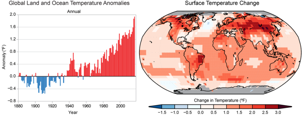
Figure 1
(left) Global annual average temperature has increased by more than 1.2°F (0.7°C) for the period 1986–2016 relative to 1901–1960. Red bars show temperatures that were above the 1901–1960 average, and blue bars indicate temperatures below the average. (right) Surface temperature change (in °F) for the period 1986–2016 relative to 1901–1960. Gray indicates missing data. From Figures 1.2. and 1.3 in Chapter 1.
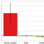
Many lines of evidence demonstrate that it is extremely likely that human influence has been the dominant cause of the observed warming since the mid-20th century. Over the last century, there are no convincing alternative explanations supported by the extent of the observational evidence. Solar output changes and internal natural variability can only contribute marginally to the observed changes in climate over the last century, and there is no convincing evidence for natural cycles in the observational record that could explain the observed changes in climate. (Very high confidence) (Ch. 1)
Figure 2
The likely range of the human contribution to the global mean temperature increase over the period 1951–2010 is 1.1° to 1.4°F (0.6° to 0.8°C), and the central estimate of the observed warming of 1.2°F (0.65°C) lies within this range (high confidence). This translates to a likely human contribution of 92%–123% of the observed 1951–2010 change. The likely contributions of natural forcing and internal variability to global temperature change over that period are minor (high confidence). (Ch. 3; Fig. ES.2)
Natural variability, including El Niño events and other recurring patterns of ocean–atmosphere interactions, impact temperature and precipitation, especially regionally, over timescales of months to years. The global influence of natural variability, however, is limited to a small fraction of observed climate trends over decades. (Very high confidence) (Ch. 1)
Global climate is projected to continue to change over this century and beyond. The magnitude of climate change beyond the next few decades will depend primarily on the amount of greenhouse (heat-trapping) gases emitted globally and on the remaining uncertainty in the sensitivity of Earth’s climate to those emissions (very high confidence). With significant reductions in the emissions of greenhouse gases, the global annually averaged temperature rise could be limited to 3.6°F (2°C) or less. Without major reductions in these emissions, the increase in annual average global temperatures relative to pre-industrial times could reach 9°F (5°C) or more by the end of this century. (Ch.1; Fig ES.3)
If greenhouse gas concentrations were stabilized at their current level, existing concentrations would commit the world to at least an additional 1.1°F (0.6°C) of warming over this century relative to the last few decades (high confidence in continued warming, medium confidence in amount of warming. (Ch.4)
Figure 3
The two panels above show annual historical and a range of plausible future carbon emissions in units of gigatons of carbon (GtC) per year (left) and the historical observed and future temperature change that would result for a range of future scenarios relative to the 1901–1960 average, based on the central estimate (lines) and a range (shaded areas, two standard deviations) as simulated by the full suite of CMIP5 global climate models (right). By 2081–2100, the projected range in global mean temperature change is 1.1°–4.3°F under the even lower scenario (RCP2.6; 0.6°–2.4°C, green), 2.4°–5.9°F under the lower scenario (RCP4.5; 1.3°–3.3°C, blue), 3.0°–6.8°F under the mid-high scenario (RCP6.0; 1.6°–3.8°C, not shown) and 5.0°–10.2°F under the higher scenario (RCP8.5; 2.8°–5.7°C, orange). See the main report for more details on these scenarios and implications. Based on Figure 4.1 in Chapter 4.
Changes in Observed and Projected U.S. Temperature
Annual average temperature over the contiguous United States has increased by 1.2°F (0.7°C) for the period 1986–2016 relative to 1901–1960 and by 1.8°F (1.0°C) based on a linear regression for the period 1901–2016 (very high confidence). Surface and satellite data are consistent in their depiction of rapid warming since 1979 (high confidence). Paleo-temperature evidence shows that recent decades are the warmest of the past 1,500 years (medium confidence). (Ch. 6)
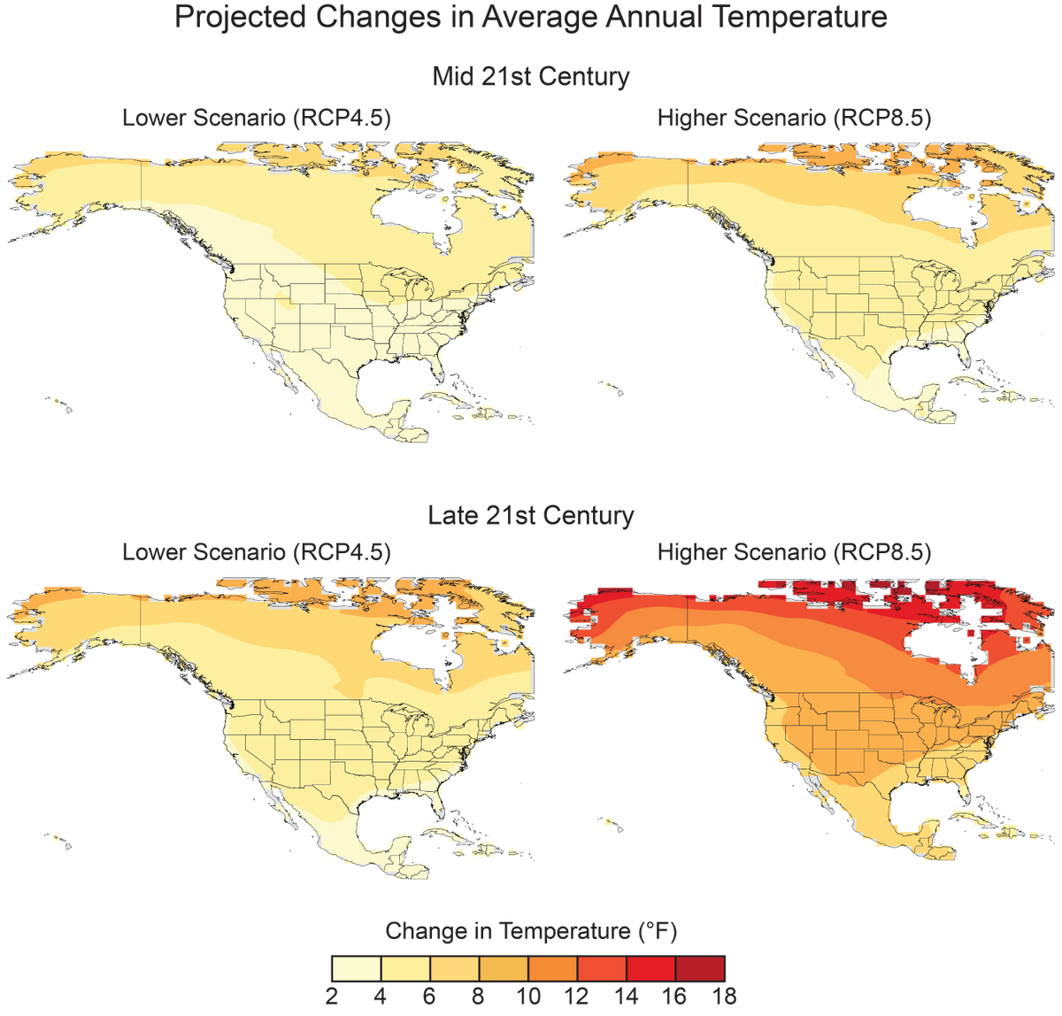
Annual average temperature over the contiguous United States is projected to rise (very high confidence). Increases of about 2.5°F (1.4°C) are projected for the period 2021–2050 relative to the average from 1976–2005 in all RCP scenarios, implying recent record-setting years may be “common” in the next few decades (high confidence). Much larger rises are projected by late century (2071–2100): 2.8°–7.3°F (1.6°–4.1°C) in a lower scenario (RCP4.5) and 5.8°–11.9°F (3.2°–6.6°C) in a higher scenario (RCP8.5) (high confidence). (Ch. 6; Fig. ES.4)
In the United States, the urban heat island effect results in daytime temperatures 0.9°–7.2°F (0.5°–4.0°C) higher and nighttime temperatures 1.8°– 4.5°F (1.0°–2.5°C) higher in urban areas than in rural areas, with larger temperature differences in humid regions (primarily in the eastern United States) and in cities with larger and denser populations. The urban heat island effect will strengthen in the future as the structure and spatial extent as well as population density of urban areas change and grow (high confidence). (Ch. 10)
Figure 4
These maps show the projected changes in annual average temperatures for mid- and late-21st century for two future pathways. Changes are the differences between the average projected temperatures for mid-century (2036–2065; top), and late-century (2070-2099; bottom), and those observed for the near-present (1976–2005). See Figure 6.7 in Chapter 6 for more details.
Many Temperature and Precipitation Extremes Are Becoming More Common
Temperature and precipitation extremes can affect water quality and availability, agricultural productivity, human health, vital infrastructure, iconic ecosystems and species, and the likelihood of disasters. Some extremes have already become more frequent, intense, or of longer duration, and many extremes are expected to continue to increase or worsen, presenting substantial challenges for built, agricultural, and natural systems. Some storm types such as hurricanes, tornadoes, and winter storms are also exhibiting changes that have been linked to climate change, although the current state of the science does not yet permit detailed understanding.
Observed Changes in Extremes
Figure 5
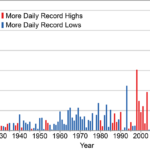
The frequency of cold waves has decreased since the early 1900s, and the frequency of heat waves has increased since the mid-1960s (the Dust Bowl era of the 1930s remains the peak period for extreme heat in the United States). (Very high confidence). (Ch. 6)
The frequency and intensity of extreme heat and heavy precipitation events are increasing in most continental regions of the world (very high confidence). These trends are consistent with expected physical responses to a warming climate. Climate model studies are also consistent with these trends, although models tend to underestimate the observed trends, especially for the increase in extreme precipitation events (very high confidence for temperature, high confidence for extreme precipitation). (Ch. 1)
Figure 6
These maps show the percentage change in several metrics of extreme precipitation by NCA4 region, including (upper left) the maximum daily precipitation in consecutive 5-year periods; (upper right) the amount of precipitation falling in daily events that exceed the 99th percentile of all non-zero precipitation days (top 1% of all daily precipitation events); (lower left) the number of 2-day events with a precipitation total exceeding the largest 2-day amount that is expected to occur, on average, only once every 5 years, as calculated over 1901–2016; and (lower right) the number of 2-day events with a precipitation total exceeding the largest 2-day amount that is expected to occur, on average, only once every 5 years, as calculated over 1958–2016. The number in each black circle is the percent change over the entire period, either 1901–2016 or 1958–2016. Note that Alaska and Hawai‘i are not included in the 1901–2016 maps owing to a lack of observations in the earlier part of the 20th century. (Figure source: CICS-NC / NOAA NCEI). Based on Figure 7.4 in Chapter 7.
Recent droughts and associated heat waves have reached record intensity in some regions of the United States; however, by geographical scale and duration, the Dust Bowl era of the 1930s remains the benchmark drought and extreme heat event in the historical record. (Very high confidence) (Ch. 8)
Northern Hemisphere spring snow cover extent, North America maximum snow depth, snow water equivalent in the western United States, and extreme snowfall years in the southern and western United States have all declined, while extreme snowfall years in parts of the northern United States have increased. (Medium confidence). (Ch. 7)
There has been a trend toward earlier snowmelt and a decrease in snowstorm frequency on the southern margins of climatologically snowy areas (medium confidence). Winter storm tracks have shifted northward since 1950 over the Northern Hemisphere (medium confidence). Potential linkages between the frequency and intensity of severe winter storms in the United States and accelerated warming in the Arctic have been postulated, but they are complex, and, to some extent, contested, and confidence in the connection is currently low. (Ch. 9)
Tornado activity in the United States has become more variable, particularly over the 2000s, with a decrease in the number of days per year with tornadoes and an increase in the number of tornadoes on these days (medium confidence). Confidence in past trends for hail and severe thunderstorm winds, however, is low (Ch. 9)
Projected Changes in Extremes
The frequency and intensity of extreme high temperature events are virtually certain to increase in the future as global temperature increases (high confidence). Extreme precipitation events will very likely continue to increase in frequency and intensity throughout most of the world (high confidence). Observed and projected trends for some other types of extreme events, such as floods, droughts, and severe storms, have more variable regional characteristics. (Ch. 1)
Both extremely cold days and extremely warm days are expected to become warmer. Cold waves are predicted to become less intense while heat waves will become more intense. The number of days below freezing is projected to decline while the number above 90°F will rise. (Very high confidence) (Ch. 6)
The frequency and intensity of heavy precipitation events in the United States are projected to continue to increase over the 21st century (high confidence). There are, however, important regional and seasonal differences in projected changes in total precipitation: the northern United States, including Alaska, is projected to receive more precipitation in the winter and spring, and parts of the southwestern United States are projected to receive less precipitation in the winter and spring (medium confidence). (Ch. 7)
The frequency and severity of landfalling “atmospheric rivers” on the U.S. West Coast (narrow streams of moisture that account for 30%–40% of the typical snowpack and annual precipitation in the region and are associated with severe flooding events) will increase as a result of increasing evaporation and resulting higher atmospheric water vapor that occurs with increasing temperature. (Medium confidence) (Ch. 9)
Projections indicate large declines in snowpack in the western United States and shifts to more precipitation falling as rain than snow in the cold season in many parts of the central and eastern United States (high confidence). (Ch. 7)
Substantial reductions in western U.S. winter and spring snowpack are projected as the climate warms. Earlier spring melt and reduced snow water equivalent have been formally attributed to human-induced warming (high confidence) and will very likely be exacerbated as the climate continues to warm (very high confidence). Under higher scenarios, and assuming no change to current water resources management, chronic, long-duration hydrological drought is increasingly possible by the end of this century (very high confidence). (Ch. 8)
The human effect on recent major U.S. droughts is complicated. Little evidence is found for a human influence on observed precipitation deficits, but much evidence is found for a human influence on surface soil moisture deficits due to increased evapotranspiration caused by higher temperatures. (High confidence) (Ch. 8)
The incidence of large forest fires in the western United States and Alaska has increased since the early 1980s (high confidence) and is projected to further increase in those regions as the climate warms, with profound changes to certain ecosystems (medium confidence). (Ch. 8)
Both physics and numerical modeling simulations generally indicate an increase in tropical cyclone intensity in a warmer world, and the models generally show an increase in the number of very intense tropical cyclones. For Atlantic and eastern North Pacific hurricanes and western North Pacific typhoons, increases are projected in precipitation rates (high confidence) and intensity (medium confidence). The frequency of the most intense of these storms is projected to increase in the Atlantic and western North Pacific (low confidence) and in the eastern North Pacific (medium confidence). (Ch. 9)
Oceans Are Rising, Warming, and Becoming More Acidic
Oceans occupy two-thirds of the planet’s surface and host unique ecosystems and species, including those important for global commercial and subsistence fishing. Understanding climate impacts on the ocean and the ocean’s feedbacks to the climate system is critical for a comprehensive understanding of current and future changes in climate.
Global Ocean Heat
Ocean heat content has increased at all depths since the 1960s and surface waters have warmed by about 1.3° ± 0.1°F (0.7° ± 0.08°C) per century globally since 1900 to 2016. Under higher scenarios, a global increase in average sea surface temperature of 4.9° ± 1.3°F (2.7° ± 0.7°C) is projected by 2100. (Very high confidence). (Ch. 13)
Global and Regional Sea Level Rise
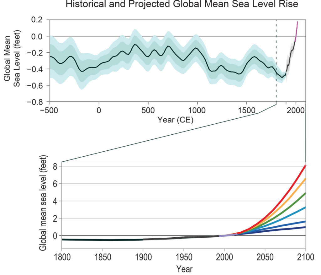
Human-caused climate change has made a substantial contribution to GMSL rise since 1900 (high confidence), contributing to a rate of rise that is greater than during any preceding century in at least 2,800 years (medium confidence). (Ch. 12; Fig. ES.8)
Relative to the year 2000, GMSL is very likely to rise by 0.3–0.6 feet (9–18 cm) by 2030, 0.5–1.2 feet (15–38 cm) by 2050, and 1.0–4.3 feet (30–130 cm) by 2100 (very high confidence in lower bounds; medium confidence in upper bounds for 2030 and 2050; low confidence in upper bounds for 2100). Future emissions pathways have little effect on projected GMSL rise in the first half of the century, but significantly affect projections for the second half of the century (high confidence). (Ch. 12)
Figure 8
The top panel shows observed and reconstructed mean sea level for the last 2,500 years. The bottom panel shows projected mean sea level for six future scenarios. The six scenarios—spanning a range designed to inform a variety of decision makers—extend from a low scenario, consistent with continuation of the rate of sea level rise over the last quarter century, to an extreme scenario, assuming rapid mass loss from the Antarctic ice sheet. Note that the range on the vertical axis in the bottom graph is approximately ten times greater than in the top graph. Based on Figure 12.2 and 12.4 in Chapter 12. See the main report for more details.
Emerging science regarding Antarctic ice sheet stability suggests that, for higher scenarios, a GMSL rise exceeding 8 feet (2.4 m) by 2100 is physically possible, although the probability of such an extreme outcome cannot currently be assessed. Regardless of emission pathway, it is extremely likely that GMSL rise will continue beyond 2100 (high confidence). (Ch. 12)
Relative sea level rise in this century will vary along U.S. coastlines due, in part, to changes in Earth’s gravitational field and rotation from melting of land ice, changes in ocean circulation, and vertical land motion (very high confidence). For almost all future GMSL rise scenarios, relative sea level rise is likely to be greater than the global average in the U.S. Northeast and the western Gulf of Mexico. In intermediate and low GMSL rise scenarios, relative sea level rise is likely to be less than the global average in much of the Pacific Northwest and Alaska. For high GMSL rise scenarios, relative sea level rise is likely to be higher than the global average along all U.S. coastlines outside Alaska. Almost all U.S. coastlines experience more than global mean sea level rise in response to Antarctic ice loss, and thus would be particularly affected under extreme GMSL rise scenarios involving substantial Antarctic mass loss (high confidence). (Ch. 12)
Coastal Flooding
Figure 9
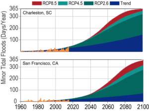
As sea levels have risen, the number of tidal floods each year that cause minor impacts (also called “nuisance floods”) have increased 5- to 10-fold since the 1960s in several U.S. coastal cities (very high confidence). Rates of increase are accelerating in over 25 Atlantic and Gulf Coast cities (very high confidence). Tidal flooding will continue increasing in depth, frequency, and extent this century (very high confidence). (Ch. 12)
Assuming storm characteristics do not change, sea level rise will increase the frequency and extent of extreme flooding associated with coastal storms, such as hurricanes and nor’easters (very high confidence). A projected increase in the intensity of hurricanes in the North Atlantic (medium confidence) could increase the probability of extreme flooding along most of the U.S. Atlantic and Gulf Coast states beyond what would be projected based solely on relative sea level rise. However, there is low confidence in the projected increase in frequency of intense Atlantic hurricanes, and the associated flood risk amplification, and flood effects could be offset or amplified by such factors, such as changes in overall storm frequency or tracks. (Ch.12; Fig. ES. 9)
Global Ocean Circulation
The potential slowing of the Atlantic meridional overturning circulation (AMOC; of which the Gulf Stream is one component)—as a result of increasing ocean heat content and freshwater-driven buoyancy changes—could have dramatic climate feedbacks as the ocean absorbs less heat and CO2 from the atmosphere. This slowing would also affect the climates of North America and Europe. Any slowing documented to date cannot be directly tied to human-caused forcing, primarily due to lack of adequate observational data and to challenges in modeling ocean circulation changes. Under a higher scenario (RCP8.5), models show that the AMOC weakens over the 21st century (low confidence). (Ch. 13)
Global and Regional Ocean Acidification
Higher-latitude systems typically have a lower buffering capacity against changing acidity, exhibiting seasonally corrosive conditions sooner than low-latitude systems. The rate of acidification is unparalleled in at least the past 66 million years (medium confidence). Under the higher scenario (RCP8.5), the global average surface ocean acidity is projected to increase by 100% to 150% (high confidence). (Ch. 13)
Acidification is regionally greater than the global average along U.S. coastal systems as a result of upwelling (e.g., in the Pacific Northwest) (high confidence), changes in freshwater inputs (e.g., in the Gulf of Maine) (medium confidence), and nutrient input (e.g., in urbanized estuaries) (high confidence). (Ch. 13)
Ocean Oxygen
Increasing sea surface temperatures, rising sea levels, and changing patterns of precipitation, winds, nutrients, and ocean circulation are contributing to overall declining oxygen concentrations at intermediate depths in various ocean locations and in many coastal areas. Over the last half century, major oxygen losses have occurred in inland seas, estuaries, and in the coastal and open ocean (high confidence). Ocean oxygen levels are projected to decrease by as much as 3.5% under the higher scenario (RCP8.5) by 2100 relative to preindustrial values (high confidence). (Ch. 13)
Climate Change in Alaska and across the Arctic Continues to Outpace Global Climate Change
Residents of Alaska are on the front lines of climate change. Crumbling buildings, roads, and bridges and eroding shorelines are commonplace. Accelerated melting of multiyear sea ice cover, mass loss from the Greenland Ice Sheet, reduced snow cover, and permafrost thawing are stark examples of the rapid changes occurring in the Arctic. Furthermore, because elements of the climate system are interconnected (see Box ES.1), changes in the Arctic influence climate conditions outside the Arctic.
Arctic Temperature Increases
Rising Alaskan permafrost temperatures are causing permafrost to thaw and become more discontinuous; this process releases additional carbon dioxide and methane resulting in additional warming (high confidence). The overall magnitude of the permafrost-carbon feedback is uncertain (Ch. 2); however, it is clear that these emissions have the potential to compromise the ability to limit global temperature increases. (Ch. 11)
Atmospheric circulation patterns connect the climates of the Arctic and the contiguous United States. Evidenced by recent record warm temperatures in the Arctic and emerging science, the midlatitude circulation has influenced observed arctic temperatures and sea ice (high confidence). However, confidence is low regarding whether or by what mechanisms observed arctic warming may have influenced the midlatitude circulation and weather patterns over the continental United States. The influence of arctic changes on U.S. weather over the coming decades remains an open question with the potential for significant impact. (Ch. 11)
Arctic Land Ice Loss
Arctic land ice loss observed in the last three decades continues, in some cases accelerating (very high confidence). It is virtually certain that Alaska glaciers have lost mass over the last 50 years, with each year since 1984 showing an annual average ice mass less than the previous year. Over the satellite record, average ice mass loss from Greenland was −269 Gt per year between April 2002 and April 2016, accelerating in recent years (high confidence). (Ch. 11)
Arctic Sea Ice Loss
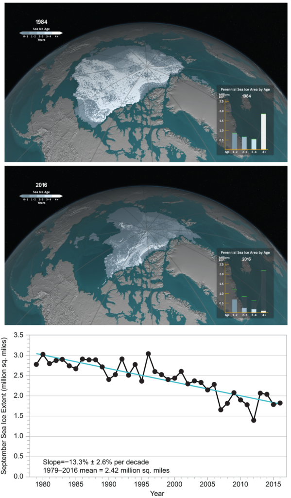
Arctic sea ice loss is expected to continue through the 21st century, very likely resulting in nearly sea ice-free late summers by the 2040s (very high confidence). (Ch. 11)
It is very likely that human activities have contributed to observed arctic surface temperature warming, sea ice loss, glacier mass loss, and northern hemisphere snow extent decline (high confidence). (Ch. 11)
Figure 10
September sea ice extent and age shown for (top) 1984 and (middle) 2016, illustrating significant reductions in sea ice extent and age (thickness). The bar graph in the lower right of each panel illustrates the sea ice area (unit: million km2) covered within each age category (> 1 year), and the green bars represent the maximum extent for each age range during the record. The year 1984 is representative of September sea ice characteristics during the 1980s. The years 1984 and 2016 are selected as endpoints in the time series; a movie of the complete time series is available at http://svs.gsfc.nasa.gov/cgi-bin/details.cgi?aid=4489. (bottom) The satellite-era arctic sea ice areal extent trend from 1979 to 2016 for September (unit: million mi2). From Figure 11.1 in Chapter 11.
Limiting Globally Averaged Warming to 2°C (3.6°F) Will Require Major Reductions in Emissions
Human activities are now the dominant cause of the observed trends in climate. For that reason, future climate projections are based on scenarios of how human activities will continue to affect the climate over the remainder of this century and beyond (see Sidebar: Scenarios Used in this Assessment). There remains significant uncertainty about future emissions due to changing economic, political, and demographic factors. For that reason, this report quantifies possible climate changes for a broad set of plausible future scenarios through the end of the century. (Ch. 2, 4, 10, 14)
Global mean atmospheric carbon dioxide (CO2) concentration has now passed 400 ppm, a level that last occurred about 3 million years ago, when global average temperature and sea level were significantly higher than today (high confidence). Continued growth in CO2 emissions over this century and beyond would lead to an atmospheric concentration not experienced in tens of millions of years (medium confidence). The present-day emissions rate of nearly 10 GtC per year suggests that there is no climate analog for this century any time in at least the last 50 million years (medium confidence). (Ch. 4)
Warming and associated climate effects from CO2 emissions persist for decades to millennia. In the near-term, changes in climate are determined by past and present greenhouse gas emissions modified by natural variability. Reducing net emissions of CO2 is necessary to limit near-term climate change and long-term warming. Other greenhouse gases (e.g., methane) and black carbon aerosols exert stronger warming effects than CO2 on a per ton basis, but they do not persist as long in the atmosphere (Ch. 2); therefore, mitigation of non-CO2 species contributes substantially to near-term cooling benefits but cannot be relied upon for ultimate stabilization goals. (Very high confidence) (Ch. 14)
Stabilizing global mean temperature to less than 3.6°F (2°C) above preindustrial levels requires substantial reductions in net global CO2 emissions prior to 2040 relative to present-day values before 2040 and likely requires net emissions to become zero or possibly negative later in the century. After accounting for the temperature effects of non-CO2 species, cumulative global CO2 emissions must stay below about 800 GtC in order to provide a two-thirds likelihood of preventing 3.6°F (2°C) of warming. Given estimated cumulative emissions since 1870, no more than approximately 230 GtC may be emitted in the future in order to remain under this temperature limit. Assuming global emissions are equal to or greater than those consistent with the RCP4.5 scenario, this cumulative carbon threshold would be exceeded in approximately two decades. (Ch. 14)
Achieving global greenhouse gas emissions reductions before 2030 consistent with targets and actions announced by governments in the lead up to the 2015 Paris climate conference would hold open the possibility of meeting the long-term temperature goal of limiting global warming to 3.6°F (2°C) above preindustrial levels, whereas there would be virtually no chance if net global emissions followed a pathway well above those implied by country announcements. Actions in the announcements are, by themselves, insufficient to meet a 3.6°F (2°C) goal; the likelihood of achieving that depends strongly on the magnitude of global emissions reductions after 2030. (High confidence) (Ch. 14)
Climate intervention or geoengineering strategies such as solar radiation management are measures that attempt to limit or reduce global temperature increases. Further assessments of the technical feasibilities, costs, risks, co-benefits, and governance challenges of climate intervention or geoengineering strategies, which are as yet unproven at scale, are a necessary step before judgments about the benefits and risks of these approaches can be made with high confidence. (High confidence) (Ch. 14)
In recent decades, land-use and land-cover changes have turned the terrestrial biosphere (soil and plants) into a net “sink” for carbon (drawing down carbon from the atmosphere), and this sink has steadily increased since 1980 (high confidence). Because of the uncertainty in the trajectory of land cover, the possibility of the land becoming a net carbon source cannot be excluded (very high confidence). (Ch. 10)
There is a Significant Possibility for Unanticipated Changes
Humanity’s effect on the Earth system, through the large-scale combustion of fossil fuels and widespread deforestation and the resulting release of carbon dioxide (CO2) into the atmosphere, as well as through emissions of other greenhouse gases and radiatively active substances from human activities, is unprecedented. There is significant potential for humanity’s effect on the planet to result in unanticipated surprises and a broad consensus that the further and faster the Earth system is pushed towards warming, the greater the risk of such surprises.
There are at least two types of potential surprises: compound events, where multiple extreme climate events occur simultaneously or sequentially (creating greater overall impact), and critical threshold or tipping pointevents, where some threshold is crossed in the climate system (that leads to large impacts). The probability of such surprises—some of which may be abrupt and/or irreversible—as well as other more predictable but difficult-to-manage impacts, increases as the influence of human activities on the climate system increases. (Ch. 15)
Positive feedbacks (self-reinforcing cycles) within the climate system have the potential to accelerate human-induced climate change and even shift the Earth’s climate system, in part or in whole, into new states that are very different from those experienced in the recent past (for example, ones with greatly diminished ice sheets or different large-scale patterns of atmosphere or ocean circulation). Some feedbacks and potential state shifts can be modeled and quantified; others can be modeled or identified but not quantified; and some are probably still unknown. (Very high confidence in the potential for state shifts and in the incompleteness of knowledge about feedbacks and potential state shifts). (Ch. 15)
The physical and socioeconomic impacts of compound extreme events (such as simultaneous heat and drought, wildfires associated with hot and dry conditions, or flooding associated with high precipitation on top of snow or waterlogged ground) can be greater than the sum of the parts (very high confidence). Few analyses consider the spatial or temporal correlation between extreme events. (Ch. 15)
While climate models incorporate important climate processes that can be well quantified, they do not include all of the processes that can contribute to feedbacks (Ch. 2), compound extreme events, and abrupt and/or irreversible changes. For this reason, future changes outside the range projected by climate models cannot be ruled out (very high confidence). Moreover, the systematic tendency of climate models to underestimate temperature change during warm paleoclimates suggests that climate models are more likely to underestimate than to overestimate the amount of long-term future change (medium confidence). (Ch. 15)
The most likely force to cause a change in climate change is money. New York City is filing a law suit against five major oil companies (BP, Chevron, ConocoPhillips, Exxon Mobil and Royal Dutch Shell), claiming they have contributed to global warming. Mayor Bill de Blasio said the city will seek billions of dollars in the lawsuit to recoup money spent by the city for resiliency efforts related to global warming.
The National Oceanic and Atmospheric Administration (NOAA) reports:
2017 will be remembered as a year of extremes for the U.S. as floods, tornadoes, hurricanes, drought, fires and freezes claimed hundreds of lives and visited economic hardship upon the nation. Recovery from the ravages of three major Atlantic hurricanes making landfall in the U.S. and an extreme and ongoing wildfire season in the West is expected to continue well into the new year
Billion-dollar disasters in 2017
Last year, the U.S. experienced 16 weather and climate disasters each with losses exceeding $1 billion, totaling approximately $306 billion — a new U.S. record.
Far more tragic was the human toll. At least 362 people died and many more were injured during the course of the disasters that included:
1 freeze;
1 drought (affected multiple areas);
1 wildfire (affected multiple areas);
2 floods;
3 major hurricanes (Harvey, Irma and Maria); and
8 severe storms.
The biggest newsmakers include the western U.S. wildfires that caused damages tallying $18 billion — triple the previous U.S. record. Losses from Hurricane Harvey exceeded $125 billion, which ranked second only to Hurricane Katrina, the costliest storm in the 38-year period of record. Hurricanes Maria and Irma had total damages of $90 billion and $50 billion, respectively. Hurricane Maria now ranks as third costliest weather and climate disaster on record for the nation, with Irma coming in close behind as fifth costliest.
Since 1980, the U.S. has sustained 219 weather and climate disasters that have exceeded $1.5 trillion in overall damages to date.
Billion Dollar Disasters
16 weather and climate disasters each with losses exceeding $1 billion
During 2017, the U.S. experienced a historic year of weather and climate disasters. In total, the U.S. was impacted by 16 separate billion-dollar disaster events tying 2011 for the record number of billion-dollar disasters for an entire calendar year. In fact, 2017 arguably has more events than 2011 given that our analysis traditionally counts all U.S. billion-dollar wildfires, as regional-scale, seasonal events, not as multiple isolated events.
More notable than the high frequency of these events is the cumulative cost, which exceeds $300 billion in 2017 — a new U.S. annual record. The cumulative damage of these 16 U.S. events during 2017 is $306.2 billion, which shatters the previous U.S. annual record cost of $214.8 billion (CPI-adjusted), established in 2005 due to the impacts of Hurricanes Dennis, Katrina, Rita and Wilma.
The National Oceanic and Atmospheric Administration (NOAA) reports:
The average U.S. temperature in 2017 was 54.6 degrees F (2.6 degrees F above average), making 2017 third warmest year in 123 years of record-keeping, according to scientists from NOAA’s National Centers for Environmental Information. In fact, the five warmest years on record for the U.S. all have occurred since 2006.
2017 was also was the 21st consecutive year that the annual average temperature exceeded the average. For the third consecutive year, every state across the contiguous U.S. and Alaska experienced above-average annual temperatures.