bookmark_borderChaos Theory: Soil, Atmosphere and Ocean Interaction With Thermal Energy and Carbon Storage

by Daniel Brouse

Chaos theory emphasizes the complexity and nonlinearity of dynamic systems, and this complexity is inherent in the interactions between soil, atmosphere, and oceans in the Earth’s climate system. Here’s how these components interact with thermal energy and carbon storage:

Soil-Atmosphere Interaction:

  1. Thermal Energy Exchange:
    • Soil plays a crucial role in the exchange of thermal energy with the atmosphere. The temperature of the soil surface affects the transfer of heat to the atmosphere through processes such as conduction and convection. The thermal properties of soil, including its composition and moisture content, influence this energy exchange.
  2. Carbon Storage and Cycling:
    • Soil acts as a reservoir for carbon in the form of organic matter. This carbon storage is dynamic and involves complex interactions between plants, microorganisms, and the soil matrix. Soil organic carbon contributes to the global carbon cycle, affecting atmospheric CO2 concentrations.
  3. Feedback Mechanisms:
    • Nonlinear feedback mechanisms between soil and atmosphere can influence climate dynamics. For example, changes in temperature and precipitation patterns may impact soil moisture, affecting vegetation growth and altering the surface energy balance.

Soil-Ocean Interaction:

  1. Carbon Storage and Sequestration:
    • Oceans play a crucial role in global carbon storage. Dissolved carbon dioxide is absorbed by the ocean, forming carbonic acid. Additionally, organic matter from marine life contributes to carbon storage in ocean sediments. The exchange of carbon between soil and oceans is interconnected and can influence atmospheric CO2 levels.
  2. Thermal Inertia:
    • Oceans have a high thermal inertia, meaning they can absorb and store large amounts of heat. This property moderates temperature extremes, influencing atmospheric temperature patterns. Changes in ocean temperatures can, in turn, impact regional and global climate dynamics.
  3. Ocean Circulation and Climate:
    • Ocean circulation patterns, such as the Atlantic Meridional Overturning Circulation (AMOC), play a role in redistributing heat around the globe. Changes in ocean circulation can have cascading effects on atmospheric circulation patterns, influencing climate on a large scale.

Atmosphere-Soil-Ocean Coupling:

  1. Teleconnections:
    • Chaos theory recognizes the concept of teleconnections, where seemingly unrelated events in one part of the Earth system influence conditions in another. For instance, changes in sea surface temperatures (linked to ocean dynamics) can affect atmospheric circulation patterns, leading to variations in precipitation and temperature on land.
  2. Climate Variability:
    • The complex interactions between soil, atmosphere, and oceans contribute to climate variability. Chaos theory helps to understand the sensitivity of the climate system to initial conditions and how small perturbations in one component can lead to significant and sometimes unpredictable outcomes.

In summary, chaos theory underscores the intricate, nonlinear, and interconnected nature of the relationships between soil, atmosphere, and oceans in the context of thermal energy and carbon storage. These interactions contribute to the Earth’s climate system’s complexity, and understanding these dynamics is crucial for accurately modeling and predicting climate changes. Ongoing research and improved modeling techniques aim to enhance our understanding of these complex interactions and their implications for climate variability and change.

Chaos Theory and Climate Change Brouse (2024)

Climate Change: Rate of Acceleration Brouse and Mukherjee (2023)

Toppled Tipping Points: The Domino Effect Brouse and Mukherjee (2023)

The Human Induced Climate Change Experiment

bookmark_borderClimate Change and How Soil Degradation Can Lead to Desertification

Why is soil integral to climate change? How does soil degradation lead to desertification?

Soil plays a crucial role in climate change mitigation and adaptation, and soil degradation can contribute to the process of desertification. Here’s why soil is integral to climate change and how soil degradation can lead to desertification:

Importance of Soil in Climate Change:

  1. Carbon Sequestration:
    • Healthy soils act as a significant carbon sink, storing large amounts of carbon in the form of organic matter. This process, known as carbon sequestration, helps mitigate climate change by reducing the concentration of greenhouse gases, particularly carbon dioxide (CO2), in the atmosphere.
  2. Water Regulation:
    • Soil influences water availability and regulates the water cycle. Healthy soils absorb and store water, reducing the risk of floods and contributing to moisture availability during dry periods. This capacity for water regulation is crucial for climate resilience.
  3. Biodiversity Support:
    • Healthy soils provide habitat and support for a diverse range of organisms, including bacteria, fungi, insects, and plant roots. Biodiversity in the soil contributes to ecosystem stability, resilience, and adaptation to changing environmental conditions.
  4. Nutrient Cycling:
    • Soil is essential for nutrient cycling, as it hosts microbial communities that break down organic matter and make nutrients available to plants. This nutrient cycling supports plant growth and contributes to overall ecosystem health.

Soil Degradation and Desertification:

  1. Erosion:
    • Soil degradation, often caused by factors like deforestation, overgrazing, and unsustainable agricultural practices, can lead to increased soil erosion. Erosion removes the topsoil layer, which is rich in organic matter and nutrients, reducing the soil’s fertility and water retention capacity.
  2. Loss of Soil Structure:
    • Poor land management practices, such as excessive plowing, deforestation, and improper irrigation, can lead to the loss of soil structure. This makes the soil more susceptible to erosion, reduces water infiltration, and hinders the growth of vegetation.
  3. Decreased Carbon Sequestration:
    • Soil degradation results in the loss of organic matter, reducing the soil’s ability to sequester carbon. This can contribute to increased atmospheric CO2 levels, exacerbating the greenhouse effect and climate change.
  4. Loss of Biodiversity:
    • Degraded soils often experience a decline in microbial and plant diversity. This loss of biodiversity weakens the soil’s resilience to environmental stresses and reduces its capacity to support healthy ecosystems.
  5. Increased Vulnerability to Climate Change:
    • Degraded soils are more vulnerable to the impacts of climate change, such as extreme weather events, droughts, and temperature variations. This vulnerability can create a feedback loop, where climate change further exacerbates soil degradation.
  6. Desertification:
    • Desertification is the process by which fertile land becomes increasingly arid and unproductive, eventually turning into desert-like conditions. Soil degradation, through erosion, loss of organic matter, and reduced water retention, is a key driver of desertification.
  7. Impact on Livelihoods:
    • Desertification poses a threat to agricultural productivity, water resources, and local livelihoods. It can lead to the displacement of communities and exacerbate social and economic challenges, contributing to a cycle of poverty and environmental degradation.

Addressing soil degradation is crucial for sustainable land management, climate change mitigation, and the prevention of desertification. Implementing conservation practices, agroforestry, reforestation, and sustainable agriculture techniques can help restore and protect soils, contributing to climate resilience and biodiversity conservation.

The Human Induced Climate Change Experiment

bookmark_borderClimate-Resilient Environment Around Your Home

by Daniel Brouse

Soil is integral to our climate.

What are the best methods to mitigate against climate change by providing wind breaks, shade, moisture retention, and climate control, around my home, as well as prevent soil degradation and desertification?

Creating a sustainable and climate-resilient environment around your home involves a combination of practices that address wind breaks, shade, moisture retention, climate control, and prevention of soil degradation. Here are some effective methods:

  1. Planting Trees and Vegetation:
    • Wind Breaks and Shade: Planting windbreaks, such as rows of trees or shrubs, can protect your home from strong winds and provide shade. Deciduous trees strategically placed on the south and west sides of your home can offer shade during hot seasons while allowing sunlight through during colder seasons.
    • Moisture Retention: Trees and vegetation help retain moisture in the soil by reducing evaporation. Mulching around plants and trees further aids in moisture retention.
    • Climate Control: Trees act as natural air conditioners, cooling the surrounding environment through a process called transpiration. This can contribute to a more comfortable microclimate around your home.
  2. Rainwater Harvesting:
    • Install rain barrels or cisterns to collect rainwater. This harvested water can be used for watering plants, reducing the need for additional irrigation and helping with moisture retention in the soil.
  3. Appropriate Plant Selection:
    • Choose native or drought-resistant plants that are well-suited to your local climate. These plants typically require less water, contribute to soil stability, and are more resilient in the face of climate variability.
  4. Contour Planting and Terracing:
    • Contour planting involves planting along the contour lines of the land to slow down water runoff, promoting infiltration and reducing soil erosion. Terracing is another method to control water runoff on sloped terrain.
  5. Ground Cover and Cover Crops:
    • Planting ground cover or cover crops helps prevent soil erosion, improves moisture retention, and contributes to overall soil health. These plants protect the soil surface from the impact of raindrops and enhance soil structure.
  6. Permeable Surfaces:
    • Use permeable surfaces, such as permeable pavers or gravel, in areas around your home. This allows rainwater to infiltrate into the soil rather than running off, contributing to soil moisture and preventing erosion.
  7. Composting:
    • Implement composting practices to improve soil structure and fertility. Healthy soils are more resistant to erosion, and they can retain moisture better, promoting plant growth.
  8. Integrated Pest Management (IPM):
    • Practice IPM techniques to manage pests without resorting to excessive use of pesticides. Healthy ecosystems are more resilient to climate stresses, and minimizing chemical inputs helps maintain biodiversity and soil health.
  9. Microclimate Planning:
    • Plan your landscaping to create microclimates around your home. For example, placing hard surfaces like rocks or pavement near the home can absorb and release heat, contributing to temperature regulation.
  10. Educate and Involve the Community:
  • Collaborate with neighbors and community members to implement sustainable practices collectively. Building awareness and working together can have a more significant impact on preventing soil degradation and desertification.

By integrating these practices, you can contribute to a more sustainable and climate-resilient environment around your home while mitigating the impacts of climate change and promoting soil health.

The Human Induced Climate Change Experiment

bookmark_borderClimate Change and Chaos Theory

By Daniel Brouse
February 5, 2024

Global warming is caused by an increase in thermal energy. Atmospheric circulation together with ocean circulation is how thermal energy is redistributed throughout the world. Chaos theory offers insights into the complex, nonlinear dynamics of climate systems role in the redistribution of thermal energy. The Earth’s climate is a highly complex and dynamic system, influenced by various factors such as ocean currents, atmospheric circulation, and feedback loops.

Circulation systems of air and/or water include:
* doldrums, trade winds, horse latitudes, prevailing westerlies, polar front zone, and polar easterlies
* each hemisphere has three cells — Hadley cell, Ferrel cell and Polar cell in which air circulates through the entire depth of the troposphere
* usually each hemispheres has two jet streams — a subtropical jet stream and a polar-front jet stream
* waves, tides, currents, downwelling, upwelling move water
* there are over 24 currents — Benguela Current, California Current, Falkland Current, Labrador Current, Brazil Current, Florida Current, Gulf Stream, West Australian Current, Canary Current, Kuroshio Current, North Pacific Current, Somali Current, Antarctic Circumpolar Current, Antarctica Current, Antilles Current, Mozambique Current, North Atlantic Drift, Norwegian Current, Oyashio Current, West Wind Drift, Agulhas Current, South Equatorial Current, Humboldt or Peruvian Current, Monsoon Current
* five major ocean-wide gyres —- the North Atlantic, South Atlantic, North Pacific, South Pacific, and Indian Ocean
* thermohaline (temperature and salinity) circulation systems — Gulf Stream, Atlantic Meridional Overturning circulation (AMOC), Pacific Meridional Overturning Circulation (PMOC)
* ocean-atmosphere oscillations — La Nina / El Niño-Southern Oscillation (ENSO), Antarctic Oscillation (AAO), Arctic Oscillation (AO), Atlantic Multidecadal Oscillation (AMO),
Indian Ocean Dipole (IOD), Madden-Julian Oscillation (MJO), North Atlantic Oscillation (NAO), North Pacific Gyre Oscillation (NPGO), North Pacific Oscillation (NPO), Pacific Decadal Oscillation (PDO), Pacific-North American (PNA) Pattern

How does chaos theory explain thermal energy redistributed throughout the world?

  1. Nonlinear Dynamics:
    • Chaos theory emphasizes the nonlinear dynamics of complex systems, meaning that small changes in initial conditions can lead to disproportionately large and unpredictable outcomes. In the context of climate, this nonlinearity is evident in how the redistribution of thermal energy is influenced by factors like ocean currents and atmospheric circulation, which can exhibit chaotic behavior.
  2. Sensitive Dependence on Initial Conditions:
    • Chaos theory also highlights the concept of sensitive dependence on initial conditions, commonly known as the butterfly effect. In climate systems, small variations in initial conditions, such as temperature or atmospheric pressure, can lead to significant changes in the distribution of thermal energy over time.
  3. Complex Feedback Loops:
    • Climate systems involve intricate feedback loops, where changes in one component can influence others. These feedback loops contribute to the complexity and unpredictability of thermal energy redistribution. Chaos theory helps us understand how these feedback mechanisms can amplify or dampen the effects of perturbations in the system.
  4. Emergent Patterns:
    • Chaos theory recognizes the emergence of complex patterns from seemingly chaotic systems. In climate science, emergent patterns may include large-scale phenomena like El Niño or the Madden-Julian Oscillation, which play roles in redistributing thermal energy on a global scale.
  5. Climate Variability and Change:
    • Chaos theory is particularly relevant in studying climate variability and change. While long-term trends such as global warming are discernible, the inherent chaos in the climate system introduces variability and uncertainty, making it challenging to precisely predict how thermal energy will be redistributed over shorter timescales.
  6. Atmospheric Rivers and Droughts:
    • Atmospheric rivers are concentrated bands of moisture in the atmosphere, and their behavior is influenced by various atmospheric factors. Chaos theory comes into play when trying to predict the exact paths and intensities of atmospheric rivers, especially as small changes in initial conditions can lead to vastly different outcomes over time. Droughts result from complex interactions between atmospheric conditions, precipitation patterns, land use, and water management. Chaos theory highlights the sensitivity of drought conditions to initial conditions and the potential for nonlinear responses, making it difficult to precisely predict the onset, duration, and severity of drought events.

Complex Feedback Loops:

Complex feedback loops in climate science refer to interactions between different components of the Earth’s climate system that can amplify or dampen the effects of initial changes, leading to non-linear and often unpredictable outcomes. These feedback loops play a crucial role in shaping the behavior of the climate system and can influence various climate phenomena, including temperature changes, ice melt, and precipitation patterns.

Tipping points are Critical Milestones that directly impact the rate of acceleration in climate change by multiplying the number and intensity of feedback loops. Identifying and understanding these tipping points is crucial for climate science and policymaking. Crossing multiple tipping points could lead to a domino effect, resulting in a much more rapid and severe climate change than currently projected.

  1. Ice-Albedo Feedback:
    • As the Earth warms, ice and snow melt, reducing the surface area covered by highly reflective materials (high albedo). This leads to a decrease in the Earth’s overall reflectivity, or albedo, as darker surfaces (like open water or bare ground) absorb more solar radiation. The increased absorption of sunlight further warms the surface, accelerating ice melt in a self-reinforcing loop.
  2. Water Vapor Feedback:
    • Warmer temperatures can lead to increased evaporation of water from oceans and other bodies of water. Since water vapor is a greenhouse gas, higher atmospheric water vapor concentrations can enhance the greenhouse effect, trapping more heat and further raising temperatures. This positive feedback loop can contribute to the amplification of global warming.
  3. Carbon Cycle Feedback:
    • The carbon cycle involves the exchange of carbon dioxide (CO2) between the atmosphere, oceans, and terrestrial ecosystems. As the climate warms, it can influence processes like the release of carbon from thawing permafrost or changes in vegetation. The additional release of carbon dioxide can amplify the greenhouse effect, leading to further warming and affecting the carbon cycle in a feedback loop.
  4. Ocean Circulation Feedback:
    • Changes in temperature and salinity affect ocean circulation patterns. Alterations in ocean circulation can, in turn, influence heat distribution across the globe. For example, a slowdown in the Atlantic Meridional Overturning Circulation (AMOC) could impact regional climate patterns and further affect ocean circulation in a complex feedback loop.
  5. Vegetation-Climate Feedback:
    • Climate changes can affect vegetation patterns, altering the amount of sunlight absorbed and the release of water vapor through transpiration. Changes in vegetation cover can influence local and regional climates, creating feedback loops that may further impact ecosystems and climate patterns.
  6. Cloud Feedback:
    • Changes in temperature and atmospheric composition can affect cloud cover and properties. While clouds can both reflect sunlight and trap heat, the net effect depends on factors like cloud altitude and type. Changes in cloud cover and properties can influence the Earth’s radiation balance, creating feedback loops that can either amplify or dampen climate changes.

Chaos theory provides a framework for understanding the inherent complexity, sensitivity, and unpredictability of climate systems, including the redistribution of thermal energy. The interconnectedness of various factors and the nonlinear interactions within the Earth’s climate contribute to the intricate patterns observed in thermal energy distribution on a global scale. Climate models use principles from chaos theory to simulate these dynamic interactions.

The Earth is a climate system. Many subsystems make up our climate. Perhaps the most important factor impacting our climate is us. The biggest influence on climate change is the increase in greenhouse gas concentrations in the Earth’s atmosphere, primarily driven by human activities. The largest drivers of human induced climate change include: burning of fossil fuels, deforestation and land use, industrial processes, agriculture, waste management, and use of fluorinated gases.

Human induced climate change is an exponential component of an unordered system (chaos theory).Chaos theory plays a role in understanding the dynamics and potential unpredictability of social-ecological systems’ impact on climate change. Social-ecological systems encompass the interconnectedness of human societies and the ecosystems they are part of, and their behavior is influenced by a myriad of factors, including human activities, policies, resource use, and environmental changes. Chaos theory contributes insights into the complexity, sensitivity to initial conditions, and potential nonlinearities within these systems.

Here are several aspects in which chaos theory can be relevant to forecasting the impact of social-ecological systems on climate change:

  1. Nonlinear Interactions:
    • Social-ecological systems involve nonlinear interactions between human activities and environmental responses. Small changes in policies, resource management, or societal behaviors can lead to disproportionately large and unpredictable outcomes in terms of climate change impacts.
  2. Sensitivity to Initial Conditions:
    • The sensitivity of social-ecological systems to initial conditions highlights the importance of understanding how small changes or decisions can lead to significant and sometimes unexpected consequences over time. This sensitivity is crucial when forecasting the trajectory of climate change impacts resulting from human activities.
  3. Feedback Loops:
    • Feedback loops within social-ecological systems can amplify or dampen the effects of interventions or changes. For example, policies to reduce greenhouse gas emissions may lead to unforeseen economic or social consequences, creating feedback loops that influence climate change impacts.
  4. Emergent Properties:
    • Chaos theory recognizes emergent properties that arise from the interactions within complex systems. In the context of social-ecological systems, emergent properties may include new social norms, economic trends, or environmental patterns that affect and potentially amplify or mitigate the impacts of climate change.
  5. Thresholds and Tipping Points:
    • Social-ecological systems can exhibit thresholds and tipping points, where small changes gradually accumulate until a critical point is reached, leading to abrupt and sometimes irreversible changes. Chaos theory helps to understand the potential for sudden shifts in behavior within these systems.
  6. Adaptive Capacity:
    • Chaos theory encourages consideration of the adaptive capacity of social-ecological systems. The ability to adapt to changing conditions, learn from experiences, and adjust strategies is essential for forecasting and managing the impacts of climate change within these systems.
  7. Uncertainty and Systemic Risks:
    • Chaos theory underscores the inherent uncertainty in complex systems. Social-ecological systems are subject to systemic risks, where interconnected factors can amplify vulnerabilities. Understanding and managing these uncertainties are crucial for forecasting and responding to climate change impacts.

Incorporating chaos theory into forecasting models for social-ecological systems helps researchers and policymakers recognize the limitations of linear thinking and deterministic approaches. Embracing complexity and uncertainty can lead to more robust and adaptive strategies for addressing the multifaceted challenges posed by climate change within the context of human societies and ecosystems.

Our model attempts to adequately account for humans and forecasts an increase of 9 degrees Celsius above pre-industrial levels.

Toppled Tipping Points: The Domino Effect Brouse and Mukherjee (2023)Tipping Cascades, Social-Ecological Systems, and the Hottest Year in History Brouse (2024)
The Reign of Violent Rain Brouse and Mukherjee (2023)
The Age of Loss and Damage Brouse (2023)
Climate Change Impacts on Flood Risks and Real Estate Values Sidd Mukherjee and Daniel Brouse (2023)
bookmark_borderClimate Change, the Jet Stream, and East Coast Atmospheric Rivers

by Daniel Brouse

How is climate change impacting the jet stream and atmospheric rivers on the East Coast of the USA?

The interactions between various factors, including ocean currents, sea surface temperatures, and atmospheric circulation, contribute to the overall climate patterns experienced on the East Coast.

Climate change can influence the jet stream and atmospheric rivers, impacting weather patterns on the East Coast of the USA. Here are some key ways in which these changes may occur:

Jet Stream:

    1. Amplification and Slowing:
      • Climate change can lead to the amplification of atmospheric patterns, including the jet stream. This can result in larger north-south swings, which may contribute to more persistent weather conditions. Additionally, a warming Arctic relative to the mid-latitudes may slow down the jet stream.
    2. Stalled Weather Patterns:
      • A slower, more meandering jet stream can lead to the persistence of weather patterns, causing prolonged periods of extreme conditions such as heatwaves, cold spells, or heavy rainfall.
    3. Shifts in Track:
      • Climate change may alter the typical track of the jet stream, influencing where it tends to position itself. These shifts can impact regional weather patterns, including precipitation and temperature distributions.
    4. Increased Amplification:
      • As the Earth’s poles warm faster than the mid-latitudes, the temperature difference between the Arctic and lower latitudes decreases. This reduction in temperature gradient may lead to a more meandering and slower jet stream with larger north-south waves, a phenomenon known as “jet stream amplification.”
    5. Wavier Jet Stream:
      • The reduced temperature contrast between the Arctic and mid-latitudes can make the jet stream more susceptible to large, slow-moving waves. This wavier pattern can result in more persistent weather conditions, including prolonged periods of heatwaves, cold spells, droughts, or heavy rainfall.
    6. Increased Blocking Patterns:
      • A wavier and slower jet stream can lead to the formation of blocking patterns, where high or low-pressure systems persist in a particular location for an extended period. Blocking patterns can contribute to prolonged and extreme weather events.
    7. Slower Movement:
      • Some studies suggest that the jet stream is slowing down as a result of climate change. A slower jet stream can cause weather systems to move more slowly across the landscape, potentially intensifying the impacts of extreme events such as storms, heatwaves, or heavy rainfall.
    8. Changes in Zonal Flow:
      • The jet stream typically flows from west to east in a relatively straight line, a pattern known as zonal flow. Climate change may lead to more frequent disruptions of this zonal flow, causing the jet stream to meander and creating conditions for more extreme weather events.
    9. Impacts on Weather Extremes:
      • Changes in the jet stream can influence the occurrence and characteristics of weather extremes, including heatwaves, cold snaps, and intense storms. These changes can have significant implications for local and regional climate patterns.

    Atmospheric Rivers:

    1. Increased Moisture Content:
      • Warmer temperatures associated with climate change can enhance evaporation, increasing the moisture content of the atmosphere. This, in turn, can contribute to the development of more intense atmospheric rivers, which are channels of concentrated moisture in the atmosphere.
    2. Changes in Intensity and Frequency:
      • Climate change may lead to alterations in the intensity and frequency of atmospheric rivers. There is evidence suggesting that these phenomena could become more common and more potent, leading to heavier rainfall events and an increased risk of flooding.
    3. Altered Trajectories:
      • Changes in the jet stream’s position and behavior can influence the trajectories of atmospheric rivers. Variations in the jet stream can result in altered paths for these moisture-laden systems, affecting the regions that experience heavy rainfall and potential flooding.
    4. Extreme Weather Events:
      • Atmospheric rivers are often associated with extreme weather events, including heavy rainfall and flooding. Changes in the characteristics of atmospheric rivers due to climate change can contribute to an increased likelihood of severe weather events on the East Coast.

East Coast Atmospheric Rivers and AMOC (Atlantic Meridional Overturning Circulation) Brouse (2024)

Extreme Rainfall–surge Hazard Risk Basics and Atmospheric Rivers Brouse (2022)

West Coast Atmospheric Rivers Brouse (2023)

East Coast Atmospheric Rivers Brouse (2023)

Greenland Atmospheric Rivers Mukherjee (2023)

Owning a Shore Property and Flood Insurance

ALSO SEE:
The Reign of Violent Rain Brouse and Mukherjee (2023)
The Age of Loss and Damage Brouse (2023)
Climate Change Impacts on Flood Risks and Real Estate Values Sidd Mukherjee and Daniel Brouse (2023)

bookmark_borderAtmospheric Rivers and Coastal Erosion

Atmospheric rivers are long, narrow bands of concentrated moisture in the atmosphere that transport large amounts of water vapor. When these atmospheric rivers make landfall, they can bring heavy rainfall over an extended period, leading to increased runoff and potentially contributing to coastal erosion through several mechanisms:

  1. Intense Rainfall: Atmospheric rivers can bring intense and prolonged rainfall, leading to increased runoff from rivers and streams into the coastal areas. This influx of water can contribute to soil erosion and sediment transport, impacting coastal ecosystems.
  2. Flooding: The heavy rainfall associated with atmospheric rivers can cause inland flooding, leading to an increased discharge of water into coastal regions. This excess water can erode coastal land, especially in areas with vulnerable soils.
  3. Storm Surges: In some cases, atmospheric rivers may coincide with storm systems, leading to storm surges along the coast. Storm surges, combined with high winds and heavy rainfall, can intensify erosion along the shoreline.

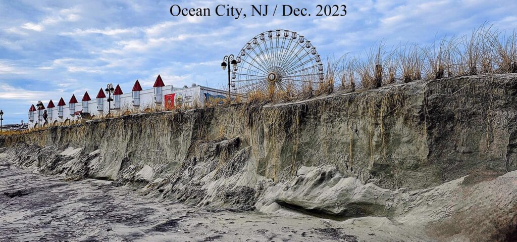
The image shows the Ocean City, New Jersey, shore after an atmospheric river coincided with storm surge.

beach erosion in Ocean City, NJ / December 2023

It’s essential to note that the impact of atmospheric rivers on coastal erosion can vary depending on local topography, land use, and other factors. Coastal erosion is a complex process influenced by a combination of natural and anthropogenic factors, including sea level rise, human activities, and changes in weather patterns.

Owning a Shore Property and Flood Insurance

Extreme Rainfall–surge Hazard Risk Basics and Atmospheric Rivers Brouse (2022)

West Coast Atmospheric Rivers Brouse (2023)

East Coast Atmospheric Rivers Brouse (2023)

Greenland Atmospheric Rivers Mukherjee (2023)

ALSO SEE:
The Reign of Violent Rain Brouse and Mukherjee (2023)
The Age of Loss and Damage Brouse (2023)
Climate Change Impacts on Flood Risks and Real Estate Values Sidd Mukherjee and Daniel Brouse (2023)

bookmark_borderTipping Cascades, Social-Ecological Systems, and the Hottest Year in History

by Daniel Brouse
January 9, 2024

Human induced climate change is an exponential component of an unordered system (chaos theory). That means global warming is accelerating at a rapid rate in a complex way.

Unfortunately, even scientists are failing to see (let alone forecast) the rapid acceleration in climate change. Due to their complexity, the impacts of the Domino Effect are being underestimated. Tipping points are Critical Milestones that directly impact the rate of acceleration in climate change by multiplying the number and intensity of feedback loops. The Domino Effect is also known as “tipping cascades” in climate science. Cascading impacts in relation to tipping points include cascading impacts across biogeophysical and social systems. Until recently, scientist have been drastically underestimating the social-ecological systems. The University of Exeter reports, “There is a notable lack of topic clusters dedicated to how humans will be impacted by climate-related tipping cascades.”

The Age of Loss and Damage is a new way of thinking about economics by combining economics, climate science, statistics, and physics. Until now, economic models have been unfit to capture the full extent of climate damage. Traditionally, “integrated assessment models” (IAMs) were used to forecast “shock” events. IAMs use “quadratic function” to calculate GDP losses by squaring the temperature change, yet ignore other methods (such as the exponential function) that are better suited for rapid change. “Climate change is fundamentally different to other shocks because once it has hit, it doesn’t go away,” said Thierry Philipponnat, author of a report by Finance Watch, a Brussels-based public interest NGO on financial issues. “And if the fundamental assumption is flawed, all the rest makes little sense — if any.”

Reuters reported, “Critics say this (IAMs) choice is doomed to underplay the likely impact – particularly if the planet hits environmental tipping points in which damage is not only irreversible but happens at an ever-accelerating rate.” Thierry Philipponnat’s report, Finance in a Hot House World, concludes: “Climate risk is growing to disruptive levels throughout the financial system and the guardians of financial stability urgently need to adapt their tools to regain control.” The report calls for economic models that do not mislead, scenario analyses that prepare the market, and a new prudential tool to address the build-up of systemic climate risk.

Traditional economics is based upon the “costs and benefits” to society. Since there are no known long-term benefits of climate change to society, the Age of Loss and Damage economics focuses on the exponential costs of climate change to society.
— from The Age of Loss and Damage / Brouse (2023)

2023: The Hottest Year in Human History
2023 was a wake-up call to both biogeophysical and social-ecological scientists. The record breaking physical and economical impacts could be felt worldwide. The record warming year was seventeen times greater than any other record increase in history. Typically record breaking temperatures are measured in 100th degrees. There were also 200 consecutive days of record breaking temperatures. Typically there are one or two record breaking days in row. The increase in intensity and frequency of record breaking heat requires forecasting models to be recast.

2023 Biogeophysical Records

Global temperatures reached exceptionally high levels in 2023. The Copernicus Climate Change Service (C3S), implemented by the European Centre for Medium-Range Weather Forecasts on behalf of the European Commission with funding from the EU, monitored several key climate indicators throughout the year, reporting on record-breaking conditions such as the hottest month on record and daily global temperature averages briefly surpassing pre-industrial levels by more than 2°C. Unprecedented global temperatures from June onwards led 2023 to become the warmest year on record – overtaking by a large margin 2016, the previous warmest year.

Highlights: 

  • 2023 is confirmed as the warmest calendar year in global temperature data records going back to 1850
  • 2023 had a global average temperature of 14.98°C, 0.17°C higher than the previous highest annual value in 2016
  • 2023 was 0.60°C warmer than the 1991-2020 average and 1.48°C warmer than the 1850-1900 pre-industrial level
  • It is likely that a 12-month period ending in January or February 2024 will exceed 1.5°C above the pre-industrial level
  • 2023 marks the first time on record that every day within a year has exceeded 1°C above the 1850-1900 pre-industrial level. Close to 50% of days were more than 1.5°C warmer then the 1850-1900 level, and two days in November were, for the first time, more than 2°C warmer.
  • Annual average air temperatures were the warmest on record, or close to the warmest, over sizeable parts of all ocean basins and all continents except Australia
  • Each month from June to December in 2023 was warmer than the corresponding month in any previous year
  • July and August 2023 were the warmest two months on record. Boreal summer (June-August) was also the warmest season on record
  • September 2023 was the month with a temperature deviation above the 1991–2020 average larger than any month in the ERA5 dataset
  • December 2023 was the warmest December on record globally, with an average temperature of 13.51°C, 0.85°C above the 1991-2020 average and 1.78°C above the 1850-1900 level for the month. You can access information specific for December 2023 in our monthly bulletin
  • Global average sea surface temperatures (SSTs) remained persistently and unusually high, reaching record levels for the time of year from April through December
  • 2023 saw a transition to El Niño. In spring 2023, La Niña came to an end and El Niño conditions began to develop, with the WMO declaring the onset of El Niño in early July.
  • High SSTs in most ocean basins, and in particular in the North Atlantic, played an important role in the record-breaking global SSTs
  • The unprecedented SSTs were associated with marine heatwaves around the globe, including in parts of the Mediterranean, Gulf of Mexico and the Caribbean, Indian Ocean and North Pacific, and much of the North Atlantic
  • 2023 was remarkable for Antarctic sea ice: it reached record low extents for the corresponding time of the year in 8 months. Both the daily and monthly extents reached all-time minima in February 2023
  • Arctic sea ice extent at its annual peak in March ranked amongst the four lowest for the time of the year in the satellite record. The annual minimum in September was the sixth-lowest
  • The atmospheric concentrations of carbon dioxide and methane continued to increase and reached record levels in 2023, reaching 419 ppm and 1902 ppb respectively. Carbon dioxide concentrations in 2023 were 2.4 ppm higher than in 2022 and methane concentrations increased by 11 ppb.
  • A large number of extreme events were recorded across the globe, including heatwaves, floods, droughts and wildfires. Estimated global wildfire carbon emissions in 2023 increased by 30% with respect to 2022 driven largely by persistent wildfires in Canada

2023 Social-Ecological Records

NOAA: 2023 A historic year of U.S. billion-dollar weather and climate disasters

In 2023, the U.S. experienced 28 separate weather and climate disasters costing at least 1 billion dollars. That number puts 2023 into first place for the highest number of billion-dollar disasters in a calendar year and included:

  • 1 winter storm/cold wave event (across the northeast U.S. in early-February).
  • 1 wildfire event (firestorm destroying town of Lahaina on Maui Island of Hawaii).
  • 1 drought and heat wave event (focused across the central and southern U.S.).
  • 4 flooding events (in California, Florida, and across the eastern and northeastern U.S.).
  • 2 tornado outbreaks (across the central and eastern U.S.).
  • 2 tropical cyclones (Idalia in Florida and Typhoon Mawar in Guam).
  • 17 severe weather/hail events (across many parts of the country).

2023 was also deadly, causing at least 492 direct or indirect fatalities — the 8th most disaster-related fatalities for the contiguous U.S. since 1980.

What Can I Do?
There are plenty of things you can do to help save the planet. Stop using fossil fuels. Consume less. Love more. Here is a list of additional actions you can take.

ALSO SEE: Climate Change: Rate of Acceleration / Brouse and Mukherjee (2023)

The Human Induced Climate Change Experiment

bookmark_borderViolent Rain and the Substrate

Daniel Brouse asked:
As the sea levels rise, how far “inland” might we see salinization of fresh water? Is it possible saltwater could infiltrate the Great Lakes?

  • Lake Superior has an elevation of 600 feet above (current) sea level and a depth of 1,332 feet.
  • Lake Ontario is 243 feet above sea level with a depth of 802 feet.
The Great Lakes
The Great Lakes

Greg Laden:
Would not reach the Great lakes, but with a little erosion, the Hudson, Lake Champlain, and the St Lawrence could become contiguous, so New England becomes an Island.

Daniel Brouse:
Thanks! I am particularly interested in the Kennebecasis River (a tributary of the Saint John River in southern New Brunswick, Canada.) Your answer is what I was looking for. Do you have any thoughts on this process… in particular, the changing topography caused by extreme rain events? You can kind-of imagine Eastern and Western North America as giant beaches with ever increasing atmospheric waves splashing down on us. The Gulf Coast will be hit from both sides. We to see increasing intensity and/or frequency in a wide variety of violent rain events including: downpours, flooding, hurricanes, cyclones, monsoons, coastal flooding, storm surges, lightning and wildfires, hail, extreme wind, and concurrent extremes. The reign of violent rain has already begun. More hillsides and shorelines are collapsing. Atmospheric rivers are dramatically increasing flash flooding in the Northeastern USA. Worldwide, stormwater systems are becoming overwhelmed. Ironically, the streets of Abu Dhabi and Dubai, UAE, flooded days before the COP28 Climate Conference. Nowhere is safe from violent rain, not even in the desert preparing for a UN meeting on the climate crisis. As a result of increasing violent rain, new drainage culverts are forming. Eventually, the culverts will transform into recurring streams, carving new canyons, creating new landscapes and islands. Increased wildfires and landslides will transform topography. At the same time as the violent rain makes its way to the sea, the sea is rising to meet the violent rain. What do you think will happen to the floodplains in North America?

Greg Laden:
I have many thoughts on this, and this has been part of my research and study for a very long time, having done coastal archaeology in North America, etc. The basic question is what is the substrate? Sea level rise of 1 meter in Maine means the sea goes up to the top line that is currently 1 meter above the sea (we are ignoring tides) and that’s it for thousands of years. That is because Maine is made out of granite. Sea level rise of 1 meter along Cape Cod, which is glacial till, means that the sea will erode horizontally many many meters. In fact, Cape Cod is a dead-peninsula walking, even given pre-AGW sea level rise. It will all wash away eventually, except any rocky bits of bedrock that might be there (but they aren’t there AFIK) So, given that, yes, storms come in to play. The rate of erosion of Cap Cod, to continue with that example, accelerated in about 1979, due to increased severe coastal storm. What happens to a given floodplain will depend totally on local conditions. Many of our floodplains are not that often flooded, especially in glacial zones where they are filled up, and lower reaches of the giant rivers, and there is a lot of infrastructure in place that will initially control things.

Daniel Brouse:
You might be interested in King of Prussia and Plymouth Meeting, PA. The train derailment in Plymouth Meeting (July 17, 2023) was caused by extreme rainfall and flash flooding that resulted in sinkholes developing in the carbonate rock under the railroad tracks. In July and December of 2023, extreme rainfall resulted in sinkholes being exposed in the carbonate rock under Route 202 in King of Prussia, PA. I guess this is part of the local conditions that vary widely from location to location?

ALSO SEE: Plymouth Meeting, Pennsylvania and the Creation of the Climate Crisis / Daniel Brouse (2023)

The Reign of Violent Rain

Greenland and the Collapse of the East Antarctic Ice Sheet

Sea Level Rise: Then and Now

Climate Change: Rate of Acceleration

Flood Insurance

The Human Induced Climate Change Experiment

bookmark_borderGravity, Sea Level Rise and Surge

by Daniel Brouse and Sidd Mukherjess

In general, the coasts that are seeing the largest storm surges are the same areas that are experiencing the fastest rate of sea level rise. The sea level does not rise at the same rate for most coastlines. Some of the conditions that determine the sea level at any given location include: water temperature (thermal expansion), circulation, ocean floor contour, ice melt, ocean dynamics, and Earth’s uneven gravity field.

Idalia Storm Surge 2023

The Shape of Things to Come
For the foreseeable future, storm surges will offer a good forecast of future sea level rise. Hurricane Idalia’s storm surge (pictured / 2023), brought a 10-15 storm surge to the northern coast of Florida. In 2022, Hurricane Ida brought a 14-20 foot storm surge to the southern coast of Florida. Ida also made landfall in Southeastern USA. Plaquemines Parish on the east bank of the Mississippi River had an estimated storm surge of at least 14 feet. Grand Isle, Louisiana, which was located just east of the landfall, was struck by 10.2 feet and rendered uninhabitable after the storm.

We know these areas of the United States will see sea levels rise at least 10-15 feet because it has already happened. Although it was only for hours, you wouldn’t want to live there during those hours. Not to mention, the frequency of these extreme weather events is rising exponentially. Thus, our recommendation to evacuate Florida now (i.e. Managed Retreat.) The billions of dollars spent to rebuild after Hurricane Ida will all be for naught. Allowing building will needlessly endanger property and lives. Parts of the world have already seen storm surges of 40 feet. I expect most North American coastlines will see sea levels rise, if only temporarily, by 20-40 feet this century. Within a generation, these areas could be submerged most of the time.

Don’t Be Fooled by Relative Variations
The level of the oceans is rising; however, some climate change deniers may try to claim that sea level is receding. Yes, in some instances certain areas will see a decline in the relative sea level. As ice melt accelerates, gravity and glacial isostatic adjustment will have a greater impact on where the sea level rises the most. Greenland is a good example. Greenland has one of the largest land ice sheets. You might think the sea would rise the fastest closest to the melt. “Greenland is like a bowl with large cracks in its sides.” The giant ice mass has sunk the ground, as well as, added a huge mass on top of it. Much of Greenland’s ice melt is just kind-of hanging out in the bowl. Two things are happening to change that:
1) As the ice mass melts, it exerts less gravitational pull on the surrounding water and the water gets pulled toward the equator.
2) At the same time, the Earth is rebounding under the bowl as the mass moves away. Much will depend on the extent and speed of the rebound. Though we don’t know how fast the rebound will happen, NASA has a satellite program gathering better data by measuring the gravitational pull on the satellite (GRACE Tellus Gravity Recovery & Climate Experiment).

At the same time that Greenland is “rising”, many cities are sinking. Alexandria, Amsterdam, Bangkok, Charleston, Miami, New Orleans, New York, Chicago, and Norfolk are all “caving in.” Houston is the 10th-fastest sinking city in the world, and the U.S. city sinking the fastest.

Sidd added, “As the ice melts off Greenland, sea level will rise around Antarctica and drop around Greenland, and as the ice melts in Antarctica, sea will rise around Greenland and drop around Antarctica. In general, sea levels fall where the ice is melting and rise on the other side of the world. There is a small effect on earth rotation and polar direction, but not enough to worry about.”

Measuring Sea Level Rise
So, one of the biggest questions in the future is how do you measure sea level rise? From where the land was pre-industrial, where the land is today, or where the land is tomorrow? In any event, the Earth crossed tipping points which make extreme sea level rise inevitable and irreversible. Planners should plan on it.

Sidd reiterated, “That 270 feet of sea level rise will take a long time. I would be more careful about the violent rain than the ice melt.”

Greenland and the Collapse of the East Antarctic Ice Sheet

Sea Level Rise: Then and Now

Climate Change: Rate of Acceleration

Flood Insurance

The Human Induced Climate Change Experiment

bookmark_borderClimate Change: Atmospheric Rivers

Extreme Rainfall–surge Hazard Risk Basics and Atmospheric Rivers Brouse (2022)

West Coast Atmospheric Rivers Brouse (2023)

East Coast Atmospheric Rivers Brouse (2023)

Greenland Atmospheric Rivers Mukherjee (2023)

ALSO SEE:

Real Estate and Flood Insurance Brouse and Mukherjee (1999 to present)
The Reign of Violent Rain Brouse and Mukherjee (2023)
The Age of Loss and Damage Brouse (2023)
Climate Change Impacts on Flood Risks and Real Estate Values Sidd Mukherjee and Daniel Brouse (2023)