National Oceanic and Atmospheric Administration (NOAA)
> November 2015 was the warmest November on record for the globe.
> January-November 2015 (YTD) was the warmest such period on record for the globe.
> September-November (N. Hemisphere fall) was the warmest such period on record for the globe.
> The November 2015 average global sea surface temperature was also the highest on record.
EARTH — As human induced climate change is realized, mammals have started showing patterns of migration. Some conditions are driving animals south due to the loss of their habitat (mostly animals living on ice, such as, seals and polar bears.) Some conditions are allowing animals to migrate further north (like humpback whales.) Some conditions are forcing animals to seek higher ground, as well as, escape salt water intrusion. (eg humans that live on islands)
* NOAA recently concluded that mammals are migrating due to global warming. “Humpback and fin whales are now able to go farther north in most winters, competing with beluga whales for resources,” a scientist for the National Oceanic and Atmospheric Administration said.
* The government of the Marshall Islands has requested climate change refugee status from the United States for former Bikini island residents. “The people of Bikini came back to us and asked us to take this proposal to the US, to request the resettlement trust fund be used to settle people in the US not just the Marshall Islands,” said Tony de Brum, Foreign Minister of the Marshall Islands. “We have not seen the final text of the legislation but the request that went in was on the basis of Kili being uninhabitable because of climate change.”
* In Paris almost 200 countries have ratified a new agreement in an attempt to help mitigate climate change. Included in the deal is $100bn fund to help developing and island countries adapt to global warming.
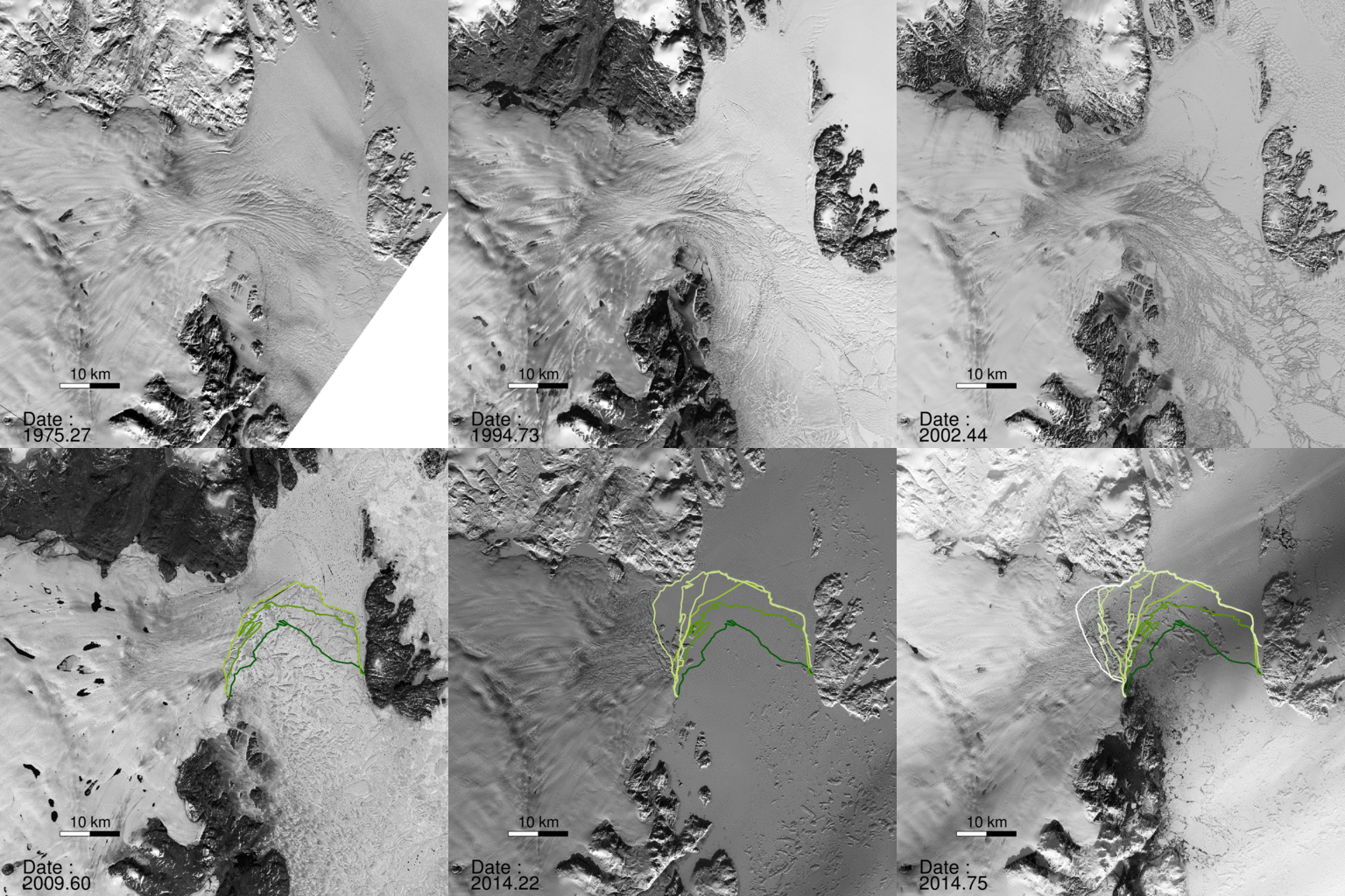
A NASA study published in the journal Science found a glacier in Greenland broke apart. “The consequences will be felt for decades to come.”
“North Greenland glaciers are changing rapidly,” said lead author Jeremie Mouginot, an assistant researcher in the Department of Earth System Science at the University of California, Irvine. “The shape and dynamics of Zachariae Isstrom have changed dramatically over the last few years. The glacier is now breaking up and calving high volumes of icebergs into the ocean, which will result in rising sea levels for decades to come.”
The scientists determined the bottom of Zachariae Isstrom is being rapidly eroded by warmer ocean water mixed with growing amounts of meltwater from the ice sheet surface. “Ocean warming has likely played a major role in triggering [the glacier’s] retreat,” Mouginot said, “but we need more oceanographic observations in this critical sector of Greenland to determine its future.”
“Zachariae Isstrom is being hit from above and below,” said the study’s senior author Eric Rignot, Chancellor’s Professor of Earth system science at UCI, and Joint Faculty Appointee at JPL. “The top of the glacier is melting away as a result of decades of steadily increasing air temperatures, while its underside is compromised by currents carrying warmer ocean water, and the glacier is now breaking away into bits and pieces and retreating into deeper ground.”
“Not long ago, we wondered about the effect on sea levels if Earth’s major glaciers in the polar regions were to start retreating,” Rignot noted. “We no longer need to wonder; for a couple of decades now, we’ve been able to directly observe the results of climate warming on polar glaciers. The changes are staggering and are now affecting the four corners of Greenland.”
THE MARSHALL ISLANDS — If your home is going underwater, you have no doubt about human induced climate change. This is the case for Bikini islanders. In the 1940’s, Bikini island was used for atomic bomb tests. The United States conducted at least 23 nuclear tests including the Bravo hydrogen bomb (the largest weapon of mass destruction at that time.) In 1946, the US relocated residents of Bikini island to another of the Marshall Islands and set up a trust fund. However, by 2011 floods, high tides and encroaching salt water began threatening their existence.
“The people of Bikini came back to us and asked us to take this proposal to the US, to request the resettlement trust fund be used to settle people in the US not just the Marshall Islands,” said Tony de Brum, Foreign Minister of the Marshall Islands. “We have not seen the final text of the legislation but the request that went in was on the basis of Kili being uninhabitable because of climate change.”
This could be the first wave of climate change refugees. It is possible that coastal cities worldwide will need to relocate during this century.
There are a growing number of scientist that have concluded climate change is severe. Recently, Jim Hansen, a professor at Columbia University’s Earth Institute, wrote:
“One conclusion we share in the latter paper is that ice sheet models that guided IPCC (Intergovernmental Panel on Climate Change) sea level projections and upcoming United Nations meetings in Paris are far too sluggish compared with the magnitude and speed of sea level changes in the paleoclimate record. An implication is that continued high emissions likely would result in multi-meter sea level rise this century and lock in continued ice sheet disintegration such that building cities or rebuilding cities on coast lines would become foolish.
The bottom line message we as scientists should deliver to the public and to policymakers is that we have a global crisis, an emergency that calls for global cooperation to reduce emissions as rapidly as practical. We conclude and reaffirm in our present paper that the crisis calls for an across-the-board rising carbon fee and international technical cooperation in carbon-free technologies. This urgent science must become part of a global conversation about our changing climate and what all citizens can do to make the world livable for future generations.”
A new study, written by James Hansen (NASA’s former lead climate scientist) and 16 co-authors, concludes that glaciers in Greenland and Antarctica will melt 10 times faster than previous estimates. The result could be a sea level rise of at least 10 feet in the next 50 years. Hanson said the new findings would be “substantially more persuasive than anything previously published.”
“We conclude that continued high emissions will make multi-meter sea level rise practically unavoidable and likely to occur this century. Social disruption and economic consequences of such large sea level rise could be devastating. It is not difficult to imagine that conflicts arising from forced migrations and economic collapse might make the planet ungovernable, threatening the fabric of civilization.”
The Weather Underground reports Antarctica hit a record high temperature. Antarctica may have experienced its warmest day ever recorded on Tuesday, with the temperature reading of 63.5°F, reports The Weather Underground.
Tuesday’s record high temperature follows another high reading of 63.3°F set just the day before. Until this week’s heat wave, the highest-known recorded temperature on the continent was 62.6°F back in 1976.
The Antarctic Peninsula where the readings were made “is one of the fastest warming spots on Earth,” reports The Weather Undergound. The website cites studies from 2012 that show the world is warming at a quickening pace.
Five nations and territories have tied or hit all-time high temperature records so far this year.
The Membrane Domain has been conducting Human Induced Climate Change Experiments since 1999. One of the first scientist to hypothesize that global warming was exponential (as opposed to the linear models) requested fellow scientists to conduct studies.
One Membrane Domain scientists began a study on the decline of the ice mass. The analysis is on-going; however, recent data leads to the conclusion that the process is exponential:
The two largest ice sheets on earth, Greenland and Antarctica, are losing mass faster and faster. The figure below is from Velicogna and Wahr, “Time-variable gravity observations of ice sheet mass balance: Precision and limitations of the GRACE satellite data” GEOPHYSICAL RESEARCH LETTERS, VOL. 40, 3055-3063, doi:10.1002/grl.50527, 2013
For reference, 360 GTonne of mass loss results in 1 mm sea level rise. Greenland lost more than that in 2012 alone.
Causes of Mass Loss
I. Marine terminated glaciers flow to the ocean and calve off icebergs. The figure below is from Rignot and Mouginot,”Ice flow in Greenland for the International Polar Year 2008-2009,” GEOPHYSICAL RESEARCH LETTERS, VOL. 39, L11501, doi:10.1029/2012GL051634, 2012
According to NOAA scientists, the average temperature for the contiguous U.S. for 2012 was 55.3°F, which was 3.2°F above the 20th century average and 1.0°F above the previous record from 1998. The year consisted of the fourth warmest winter, a record warm spring, the second warmest summer, and a warmer-than-average autumn. Although the last four months of 2012 did not bring the same unusual warmth as the first 8 months of the year, the September through December temperatures were warm enough for 2012 to remain the record warmest year, by a wide margin.
The average precipitation total for the contiguous U.S. for 2012 was 26.57 inches, 2.57 inches below average, and the 15th driest year on record for the nation.
The U.S. Climate Extremes Index indicated that 2012 was the second most extreme year on record for the nation. The index, which evaluates extremes in temperature and precipitation, as well as landfalling tropical cyclones, was nearly twice the average value and second only to 1998.
Flooding From TsunamiJapan's Coast Before the Earthquaker
NASA’s Terra satellite’s first view of northeastern Japan in the wake of a devastating earthquake and tsunami reveal extensive flooding along the coast. The Moderate Resolution Imaging Spectroradiometer (MODIS) acquired the top image of the Sendai region on March 12, 2011, at 10:30 a.m. The lower image, taken by Terra MODIS on February 26, 2011, is provided as a point of reference.
Water is black or dark blue in these images. It is difficult to see the coastline in the March 12 image, but a thin green line outlines the shore. This green line is higher-elevation land that is above water, presumably preventing the flood of water from returning to the sea. The flood indicator on the lower image illustrates how far inland the flood extends.
Both images were made with infrared and visible light, a combination that increases the contrast between muddy water and land. Plant-covered land is green, while snow-covered land is pale blue. Clouds are white and pale blue. The paved surfaces in the city of Sendai colors it brown.
MODIS detected a fire burning near the shore north of Sendai. The fire is marked with a red box. It is also surrounded by floods.
The photo-like true-color image acquired a few hours later shows plumes of sediment washed into the ocean along the coast and a dark plume of smoke near Sendai. Both images are from the MODIS Rapid Response System, which provides twice-daily images of Japan.
NASA images courtesy the MODIS Rapid Response Team at NASA GSFC. Caption by Holli Riebeek.