bookmark_border4.4 Earthquake Shakes California

An earthquake registering 4.4 Magnitude shook Southern California on St. Patrick’s Day.

Time:
Location: 34.135°N 118.486°W (9km NNW of Westwood, California)
Depth: 9.9km

Nearby Cities

  1. 9km (6mi) NNW of Westwood, California
  2. 10km (6mi) NW of Beverly Hills, California
  3. 12km (7mi) W of Universal City, California
  4. 12km (7mi) N of Santa Monica, California
  5. 562km (349mi) SSE of Sacramento, California
4.4 California Earthquake

The LA Times reported:
Robert Graves, a seismologist with the U.S. Geological Survey, told reporters that Monday’s earthquake was the most significant shake in this Southern California area since the magnitude 5.5 earthquake in Chino Hills in 2008.

The region where the fault hit has not been seismically active recently, Graves said.

“The location is somewhat surprising. It’s within the Santa Monica Mountains. We have not seen seismicity in it in recent times,” said Caltech seismologist Egill Hauksson.

L.A. Mayor Eric Garcetti confirmed the city had no reports of damage.

“Today’s earthquake is a reminder that every L.A. family must be prepared with food, water and other essentials, as well as a plan,” the mayor said in a statement.

bookmark_border4.1 Earthquake Hits South Carolina

Event Time
2014-02-15 03:23:38 UTC
2014-02-14 22:23:38 UTC-05:00 at epicenter
2014-02-14 22:23:38 UTC-05:00 system time

Location — 33.812°N 82.063°W depth=4.9km (3.0mi)

Nearby Cities
12km (7mi) WNW of Edgefield, South Carolina
31km (19mi) NNE of Evans, Georgia
32km (20mi) N of Martinez, Georgia
35km (22mi) NNW of North Augusta, South Carolina
97km (60mi) WSW of Columbia, South Carolina

Earthquakes in the Inland Carolinas Region

Since at least 1776, people living inland in North and South Carolina, and in adjacent parts of Georgia and Tennessee, have felt small earthquakes and suffered damage from infrequent larger ones. The largest earthquake in the area (magnitude 5.1) occurred in 1916. Moderately damaging earthquakes strike the inland Carolinas every few decades, and smaller earthquakes are felt about once each year or two.

Earthquakes in the central and eastern U.S., although less frequent than in the western U.S., are typically felt over a much broader region. East of the Rockies, an earthquake can be felt over an area as much as ten times larger than a similar magnitude earthquake on the west coast. A magnitude 4.0 eastern U.S. earthquake typically can be felt at many places as far as 100 km (60 mi) from where it occurred, and it infrequently causes damage near its source. A magnitude 5.5 eastern U.S. earthquake usually can be felt as far as 500 km (300 mi) from where it occurred, and sometimes causes damage as far away as 40 km (25 mi).

Faults

Earthquakes everywhere occur on faults within bedrock, usually miles deep. Most bedrock beneath the inland Carolinas was assembled as continents collided to form a supercontinent about 500-300 million years ago, raising the Appalachian Mountains. Most of the rest of the bedrock formed when the supercontinent rifted apart about 200 million years ago to form what are now the northeastern U.S., the Atlantic Ocean, and Europe.

At well-studied plate boundaries like the San Andreas fault system in California, often scientists can determine the name of the specific fault that is responsible for an earthquake. In contrast, east of the Rocky Mountains this is rarely the case. The inland Carolinas region is far from the nearest plate boundaries, which are in the center of the Atlantic Ocean and in the Caribbean Sea. The region is laced with known faults but numerous smaller or deeply buried faults remain undetected. Even the known faults are poorly located at earthquake depths. Accordingly, few, if any, earthquakes in the inland Carolinas can be linked to named faults. It is difficult to determine if a known fault is still active and could slip and cause an earthquake. As in most other areas east of the Rockies, the best guide to earthquake hazards in the seismic zone is the earthquakes themselves.

bookmark_borderScientists Jailed Over Earthquake

ITALY — Six of Italy’s top seismologists and natural disaster scientists, as well as, a government official have been sentenced to prison terms over the 2009 L’Aquila earthquake. The quake killed 300 people and destroyed the city.

The court ruled the scientists guilty of manslaughter and sentenced them to 6 years in jail.

Over 5000 international scientists sent an open letter to President Giorgio Napolitano denouncing the trial.

Enzi Boschi (former president of Italy’s National Institute of Geophysics and Volcanology) said, ”I am disappointed and devastated. I thought I would be cleared. I still don’t understand of what I am accused.”

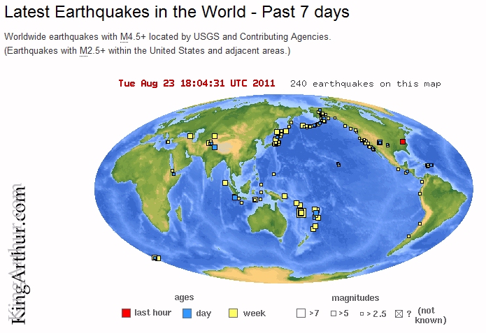
bookmark_borderNortheastern United States Earthquake

Magnitude 5.9 – VIRGINIA
2011 August 23 17:51:03 UTC

U.S. Geological Survey

West-Chester-Earthquake

Earthquake Details

This event has been reviewed by a seismologist.

Magnitude 5.9
Date-Time

Tuesday, August 23, 2011 at 17:51:03 UTC
Tuesday, August 23, 2011 at 01:51:03 PM at epicenter

Location 37.975°N, 77.969°W
Depth 1 km (~0.6 mile) (poorly constrained)
Region VIRGINIA
Distances

6 km (4 miles) SSE (152°) from Louisa, VA
6 km (4 miles) SW (236°) from Mineral, VA
26 km (16 miles) SE (133°) from Gordonsville, VA
66 km (41 miles) NW (318°) from Richmond, VA
134 km (83 miles) SW (219°) from Washington, DC

Location Uncertainty horizontal +/- 10.9 km (6.8 miles); depth +/- 7.4 km (4.6 miles)
Parameters NST=390, Nph=390, Dmin=57.9 km, Rmss=1.17 sec, Gp= 47°,
M-type=regional moment magnitude (Mw), Version=6
Source

Magnitude: USGS NEIC (WDCS-D)
Location: USGS NEIC (WDCS-D)

Event ID usc0005ild

Felt in West Chester, PA.

bookmark_borderJapan Moves 8 Feet and Our Days Are Shortened

Scientists have reported the earthquake moved the main island of Japan by 8 feet (2.4 meters) and shifted the Earth on its axis.

“At this point, we know that one GPS station moved (8 feet), and we have seen a map from GSI (Geospatial Information Authority) in Japan showing the pattern of shift over a large area is consistent with about that much shift of the land mass,” said Kenneth Hudnut, a geophysicist with the U.S. Geological Survey (USGS).

“This shift in the position of the figure axis will cause the Earth to wobble a bit differently as it rotates, but will not cause a shift of the Earth’s axis in space – only external forces like the gravitational attraction of the sun, moon, and planets can do that,” Gross said.

Dr. Roger Musson from the BGS (British Geological Survey) told that the shifting observed after the earthquake was “in line with what you get when you have an earthquake this big”.

The change in the earth’s axis shortened the day by about 1.8 millionths of a second.

bookmark_borderChaos Theory and Tsunami Reach California

Has a tsunami ever affected the United States? Yes… just last week.

Chaos Theory

Manmade and natural events can change important characteristics of U.S. waterways, ports, and harbors, and investigating those changes are an important responsibility for NOAA’s Office of Coast Survey. Following last week’s tsunami, Coast Survey’s staff and equipment on the West Coast are assisting with detection of submerged debris in critical marine transportation arteries along the coast.

The tsunami left the port at Crescent City, Calif., in a shambles, with marine debris and wreckage above and below the waterline. The U.S. Army Corps of Engineers asked Coast Survey to assist with hydrographic survey support there, to help make sure commercial and recreational vessels can begin to navigate safely and efficiently once again.

The U.S. Coast Guard and the Army Corp of Engineers also asked Coast Survey to survey the federal channel at Santa Cruz, Calif., which also experienced extensive damage and destruction to boats.

Coast Survey staff and navigation response teams have deployed to both port areas, and are coordinating with USCG and USACE to begin the hydrographic surveys.

Using a small boat equipped with powerful echo-sounding SONAR equipment, the teams will search the seafloor for sunken vessels, debris, and other hazards dangerous to commercial shippers and recreational boaters. The teams will also check the areas for shoaling. If the teams find shoaling, they will measure the bathymetry for updating NOAA’s nautical charts of the areas.

The Coast Survey navigation manager based in California is coordinating rapid response survey requests and navigational resources from areas impacted by last week’s tsunami.

bookmark_borderFlooding From Japan’s Earthquake Tsunami

Flooding From Tsunami
Japan's Coast Before the Earthquaker

NASA’s Terra satellite’s first view of northeastern Japan in the wake of a devastating earthquake and tsunami reveal extensive flooding along the coast. The Moderate Resolution Imaging Spectroradiometer (MODIS) acquired the top image of the Sendai region on March 12, 2011, at 10:30 a.m. The lower image, taken by Terra MODIS on February 26, 2011, is provided as a point of reference.

Water is black or dark blue in these images. It is difficult to see the coastline in the March 12 image, but a thin green line outlines the shore. This green line is higher-elevation land that is above water, presumably preventing the flood of water from returning to the sea. The flood indicator on the lower image illustrates how far inland the flood extends.

Both images were made with infrared and visible light, a combination that increases the contrast between muddy water and land. Plant-covered land is green, while snow-covered land is pale blue. Clouds are white and pale blue. The paved surfaces in the city of Sendai colors it brown.

MODIS detected a fire burning near the shore north of Sendai. The fire is marked with a red box. It is also surrounded by floods.

The photo-like true-color image acquired a few hours later shows plumes of sediment washed into the ocean along the coast and a dark plume of smoke near Sendai. Both images are from the MODIS Rapid Response System, which provides twice-daily images of Japan.

NASA images courtesy the MODIS Rapid Response Team at NASA GSFC. Caption by Holli Riebeek.

Instrument: Terra – MODIS