bookmark_borderSan Francisco Bay’s Double Whammy

by Daniel Brouse and Sidd Mukherjee

Coastal communities are being forced to adapt to rising sea levels; however, San Francisco has an even bigger problem — sinking land. In a report published in Science Advances (07 Mar 2018: Vol. 4, no. 3, eaap9234 / DOI: 10.1126/sciadv.aap9234), the Bay Area has to face both rising sea levels and sinking land.

The report indicates that the sinking land (called land subsidence) will increase the reach and damage of flooding in the Bay Area. The impact will be more dramatic than predicted in the forecasts for 2100.

“It’s a very well-known problem, but we really don’t know how fast it’s going to be in the second half of the 21st century. This is a projection,” Dr. Shirzaei said.
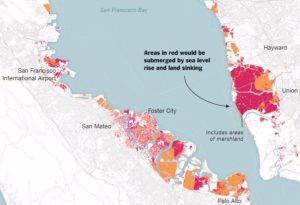
San Fransisco Bay Circa 2100

Abstract

by Manoochehr Shirzaei and Roland Bürgmann

The current global projections of future sea level rise are the basis for developing inundation hazard maps. However, contributions from spatially variable coastal subsidence have generally not been considered in these projections. We use synthetic aperture radar interferometric measurements and global navigation satellite system data to show subsidence rates of less than 2 mm/year along most of the coastal areas along San Francisco Bay. However, rates exceed 10 mm/year in some areas underlain by compacting artificial landfill and Holocene mud deposits. The maps estimating 100-year inundation hazards solely based on the projection of sea level rise from various emission scenarios underestimate the area at risk of flooding by 3.7 to 90.9%, compared with revised maps that account for the contribution of local land subsidence. Given ongoing land subsidence, we project that an area of 125 to 429 km2 will be vulnerable to inundation, as opposed to 51 to 413 km2 considering sea level rise alone.

The flood risks across the whole USA are seriously underestimated

The following paper covers all flood risk, not just the coasts, but inland and all the causes including sea level rise as well as flooding rivers and large precipitation events outside watersheds.

doi: 10.1088/1748-9326/aaac65

http://iopscience.iop.org/article/10.1088/1748-9326/aaac65/meta

“Estimates of present and future flood risk in the conterminous United States”
Oliver E J Wing ,  Paul D Bates, Andrew M Smith, Christopher C Sampson, Kris A Johnson, Joseph Fargione  and Philip Morefield

Environ. Res. Lett. 13 (2018) 034023

Wing et al. analyze flood risk in the US lower 48. Apparently 41 million are at risk rather than 13 million in current FEMA estimates.

WARNING: this paper specifically does not cover sea levels rise and increased precipitation.

“Our data show that the total US population exposed to serious flooding is 2.6–3.1 times higher than previous estimates, and that nearly 41 million Americans live within the 1% annual exceedance probability floodplain (compared to only 13 million when calculated using FEMA flood maps)”

“The analysis shows that 40.8 million people (13.3% of the population) are currently exposed to a 1 in 100 year (1% annual exceedance probability) fluvial or pluvial flood in the CONUS, which translates to a GDP exposure of $2.9 trillion (15.3% of total GDP)”

“This analysis indicates that previous estimates capture roughly one-third of the exposure identified in our 1 in 100 year floodplain.”

“It doesn’t take into account sea level rise and heavier rainfall expected to come along with climate change, so it likely underestimates the exposure, the authors warned.”
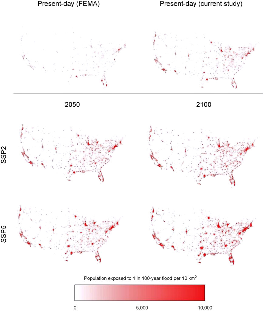
Revised Floodplain Map

https://www.houstonchronicle.com/news/houston-texas/houston/amp/28-million-Americans-live-in-flood-zones-and-12732279.php
Part of the study Who Pays For Flood Insurance?

bookmark_borderUnderwater: Sea Level Rise

In a recent study by Matthias Mengel, Alexander Nauels, Joeri Rogelj & Carl-Friedrich Schleussner entitled “Committed sea-level rise under the Paris Agreement and the legacy of delayed mitigation action” published in the Journal Nature, the authors contend — sea levels will rise between 0.7 and 1.2 meters (27-47 inches) in the next two centuries even if governments end the fossil fuel era as committed to under the Paris climate agreement.

THE ABSTRACT
Sea-level rise is a major consequence of climate change that will continue long after emissions of greenhouse gases have stopped. The 2015 Paris Agreement aims at reducing climate-related risks by reducing greenhouse gas emissions to net zero and limiting global-mean temperature increase. Here we quantify the effect of these constraints on global sea-level rise until 2300, including Antarctic ice-sheet instabilities. We estimate median sea-level rise between 0.7 and 1.2 m, if net-zero greenhouse gas emissions are sustained until 2300, varying with the pathway of emissions during this century. Temperature stabilization below 2 °C is insufficient to hold median sea-level rise until 2300 below 1.5 m. We find that each 5-year delay in near-term peaking of CO2 emissions increases median year 2300 sea-level rise estimates by ca. 0.2 m, and extreme sea-level rise estimates at the 95th percentile by up to 1 m. Our results underline the importance of near-term mitigation action for limiting long-term sea-level rise risks.

A 3-foot rise in sea level would put much of the United States’ East Coast, Florida and New Orleans underwater.

3 Feet Rise in Sea Level Impact on the East Coast

Created with NOAA’s Sea Level Rise Viewer

RESOURCES:
The Human Induced Climate Change Experiment
Rising Sea Level
Flood Insurance (Who Pays For It?)

bookmark_borderSea Level Rise and Property Values

“Disaster on the Horizon: The Price Effect of Sea Level Rise”

Asaf Bernstein, Matthew Gustafson, and Ryan Lewis.

Sea level rise coming home, the market is paying attention (Halleluia! who woulda thunk it. The real estate market, especially on the coasts is a wretched hive of villainy))

The first sentence of the abstract is “Homes exposed to sea level rise (SLR) sell at a 7% discount relative to observably equivalent unexposed properties equidistant from the beach.”

More:

“This effect is primarily driven by properties unlikely to be inundated for over half a century, suggesting that it is driven by investors pricing long horizon concerns about SLR costs.”

” … the SLR exposure discount has increased substantially over the past decade, coinciding with both increased awareness and more pessimistic prognoses about the extent and speed of rising oceans. In particular, we document increased transaction volume and lower prices for sophisticated buyers following the significant revisions of the IPCC’s 2013 release, which increased SLR projects and awareness.”

” … properties that will experience ocean encroachment after 1 foot of global average sea level rise trading at a 22%, 2-3 feet at a 17% discount, 4-5 feet at a 9% discount and 6 feet at a 6% discount. [4] Using the long run discount rate provided by Giglio et al. (2014) and assuming complete loss at the onset of inundation, we estimate that markets expect 1 foot of sea level rise within 35 years, 2-3 feet within 45 years, 4-5 feet after 65 years, and 6 feet in 80 years. These results are consistent with the medium to high projections provided in Parris et al. (2012) and utilized by the NOAA in their 2012 report.

” … exposed non-owner occupied properties trade at a 10% to 11% discount, relative to comparable non-exposed properties. ”

” … expectations regarding future SLR have steadily increased over the course of our sample period … At the beginning of our sample in 2007 we find no significant difference between the prices of exposed and unexposed properties. By the end of our sample in 2016, exposed non-owner occupied properties are priced approximately 13.5% below comparable unexposed properties.”

” … we find evidence that the discount applied to non-owner occupied properties increased from 8.1% to 14.0% following the IPCC release.

” … consistent with the idea that as information about SLR risks comes to light, exposed properties should be more likely to transact, we find that the annual probability of turnover is approximately 0.2 percentage points higher for exposed properties between 2011 and 2016 (relative to a base transaction rate of approximately 11% for all properties). This is entirely driven by the period following the IPCC report where we see a 0.8 percentage point increase in the annual probability of an exposed property transacting.”

I see a remake of the “The Big Short” coming up. A good title might be “Underwater.”

Open access (no doi ?!) . Read the whole thing:

https://papers.ssrn.com/sol3/papers.cfm?abstract_id=3073842

sidd

MORE RESOURCES:

Climate Change And Credit
Real Estate and the Rising Sea Level
Top 5 Risks
How Do We Handle Flood Risk?
Senegal Forecasts Climate Change Changes
Biloxi-Chitimacha-Choctaw Indians Climate Change Refugees
Atlantic City Going Under
Biggert Waters Flood Insurance Reform Act of 2012
Flood Insurance Reform 2011
About Flood Insurance
Who Pays For Flood Losses?
Floodplain Maps Force Towns Into Tricky Waters
Head of the Federal Flood Insurance Program Resigns
Sacramento And FEMA Fight On Flood Insurance
Global Warming


bookmark_borderClimate Change And Credit

by Daniel Brouse

Part of a series of articles on Climate Change And Flood Insurance

Homeowners living in flood plain have learned the hard way that climate change has effected their ability to get a mortgage. As the sea level rises and extreme weather events intensify, homeowners have found their insurance rates increasing or their total inability to obtain insurance coverage. Without insurance it is very, very hard to get a mortgage.

Moody’s credit ratings are now going to have a similar impact on municipalities. “What we want people to realize is: If you’re exposed, we know that. We’re going to ask questions about what you’re doing to mitigate that exposure,” Lenny Jones, a managing director at Moody’s, said in an interview. “That’s taken into your credit ratings.”

Bloomberg news agency reports:

In its report, Moody’s lists six indicators it uses “to assess the exposure and overall susceptibility of U.S. states to the physical effects of climate change.” They include the share of economic activity that comes from coastal areas, hurricane and extreme-weather damage as a share of the economy, and the share of homes in a flood plain.

Based on those overall risks, Texas, Florida, Georgia and Mississippi are among the states most at risk from climate change. Moody’s didn’t identify which cities or municipalities were most exposed.

“If I was a city official, I’d be asking a whole lot of questions about what vulnerabilities their community has, and how each new proposed development adds to that vulnerability,” said Rob Moore, a senior policy analyst at the Natural Resources Defense Council. “Because at some point, your creditors certainly will.”

Real Estate and the Rising Sea Level
Top 5 Risks
How Do We Handle Flood Risk?
Senegal Forecasts Climate Change Changes
Biloxi-Chitimacha-Choctaw Indians Climate Change Refugees
Atlantic City Going Under
Biggert Waters Flood Insurance Reform Act of 2012
Flood Insurance Reform 2011
About Flood Insurance
Who Pays For Flood Losses?
Floodplain Maps Force Towns Into Tricky Waters
Head of the Federal Flood Insurance Program Resigns
Sacramento And FEMA Fight On Flood Insurance
Global Warming


bookmark_borderEmissions Worst Ever

The World Meteorological Organization reported on October 30, 2017:
Greenhouse gas concentrations surge to new record

Green-House-Gas-Bulletin-2017.pdf

Concentrations of carbon dioxide in the atmosphere surged at a record-breaking speed in 2016 to the highest level in 800,000 years, according to the World Meteorological Organization’s Greenhouse Gas Bulletin. The abrupt changes in the atmosphere witnessed in the past 70 years are without precedent.

Globally averaged concentrations of CO2 reached 403.3 parts per million in 2016, up from 400.00 ppm in 2015 because of a combination of human activities and a strong El Niño event. Concentrations of CO2 are now 145% of pre-industrial (before 1750) levels, according to the Greenhouse Gas Bulletin.

Rapidly increasing atmospheric levels of CO2 and other greenhouse gases have the potential to initiate unprecedented changes in climate systems, leading to “severe ecological and economic disruptions,” said the report.

The annual bulletin is based on observations from the WMO Global Atmosphere Watch Programme. These observations help to track the changing levels of greenhouse gases and serve as an early warning system for changes in these key atmospheric drivers of climate change.

Population growth, intensified agricultural practices, increases in land use and deforestation, industrialization and associated energy use from fossil fuel sources have all contributed to increases in concentrations of greenhouse gases in the atmosphere since the industrial era, beginning in 1750.

Since 1990, there has been a 40% increase in total radiative forcing – the warming effect on our climate – by all long-lived greenhouse gases, and a 2.5% increase from 2015 to 2016 alone, according to figures from the US National Oceanic and Atmospheric Administration quoted in the bulletin.

“Without rapid cuts in CO2 and other greenhouse gas emissions, we will be heading for dangerous temperature increases by the end of this century, well above the target set by the Paris climate change agreement,” said WMO Secretary-General Petteri Taalas. “Future generations will inherit a much more inhospitable planet, “ he said.

“CO2 remains in the atmosphere for hundreds of years and in the oceans for even longer. The laws of physics mean that we face a much hotter, more extreme climate in the future. There is currently no magic wand to remove this CO2 from the atmosphere,”said Mr Taalas.

The last time the Earth experienced a comparable concentration of CO2 was 3-5 million years ago, the temperature was 2-3°C warmer and sea level was 10-20 meters higher than now.

In a separate report, the United Nations (UN) released the Emissions Gap Report for 2017. The report concludes that world treaties are only slowing emissions by 1/3 of what is needed to meet the maximum 2 degree rise in temperature. A 2 degree Celsius rise in temperature would likely cause a 20-40 foot rise in sea levels.

Emissions-Gap-Report_2017.pdf

If the trend continues, most coastal and port cities (including the Jersey Shore and Philadelphia) will be submerged in your lifetime.

2 Degree Temp. Rise and Sea Level Rise
New Jersey Shore Under Sea Level

bookmark_borderSenegal Forecasts Climate Change Changes

Senegal is an African country on the west coast of the continent. The country is on the forefront of global warming’s impacts.

“Climate change makes life harder for Senegalese farmers in many different ways: shorter rainy seasons, more frequent and longer dry spells and droughts, a lower water table, floods, coastal erosion, destruction of mangroves, and disruption of fish stocks. But most pernicious of all is the salinization of soil across large tracts of coastal and riverine farmland,” reports the IRIN news agency.

Salinization is an example of a problem that is likely to effect many areas in the United States.

“For decades in Sine-Saloum, the soil, which used to be known for its quality and productivity, has been badly damaged by climate change, which has led to the salinization of the waterways of the delta,” explained Seydou Cissé, who works at Senegal’s National Institute of Pedology (the study of soils).

In an attempt to abate the problem, anti-salt dykes were built. They did help for a while; however, man’s plans do not compare to the force of nature. Already several islands along the Saint-Louis river have been washed away. “Three or four days after the rain, everything goes white. There are piles of salt. All the crops we sow die. All this is due to the salinity caused by the rising waters of the sea. And when we store valuables in our rooms, rust eats away little-by-little and eventually destroys them,” said Fatou Faye, a resident of Diamniadio island said in 2015. Since that time, the island has been washed away.

“When the sea enters in the river, because you have increasing of salt, it has killed many mangroves. And you know the mangroves are the nurseries of all the seafood,” said Aissata Dia of Actionaid Senegal.

“When the tide is high, the water goes into the kitchen and then gradually the water enters the rooms. My kitchen was rebuilt last year, but even today it is threatened by the rising waters. The high salinity of the seawater eventually breaks down even the cement. After three years, the building collapses,” said islander Faye.

In 2017, a sea wall built to help protect Senegal failed. The miles long breach is not repairable.

Reuters reported in May of 2017: “As Senegal’s coast crumbles, residents ponder move to safer ground”

“A French man told us once that there will be a time when this land won’t exist,” said Badiane, who lives in the working-class district of Guet Ndar. “Maybe in 30 years, maybe in 50. I don’t know.”

“(The people) are trying to fight, but in reality the phenomenon has become very serious,” said Abdou Sane, a former parliamentarian based in Dakar who has spearheaded efforts to reduce the threat of disasters. “It exceeds the means of the government, the means of communities,” he added.

Experts have urged the government to relocate other communities before they face a similar fate.

A UN-Habitat program in 2011 helped move about 60 families out of Guet Ndar to a settlement a short distance inland.

“That’s a way of being resilient,” said Mateugue Diack, a professor of agronomy and disaster risk reduction at the nearby Gaston Berger University.

But communication was lacking and people were reluctant to move, he said. The relocation effort fizzled out before it was completed.

Guet Ndar is populated primarily by fishermen whose families have lived there for generations. Most of those who have lost their homes have remained in the overcrowded area, squeezing in with relatives and neighbors.

“Unfortunately my country is one of those that has this huge problem. We always record that something may happen, that something has happened… but still do nothing,” said Diack.

bookmark_borderCities Sink Faster Than Seas Rise

Are sea levels rising due to global warming? Yes. Coastal cities are getting a double whammy.

NASA reports: a review article published by a team of scientists who recently assembled in New Orleans, La., and in Venice, Italy, to examine the problem. Extraction of groundwater or fossil fuels, and sometimes simply generations of farming, are causing large metropolitan areas in coastal zones around the world to subside surprisingly quickly—making the relative rise of adjacent seas an even greater potential hazard.

“Sea level rise is a problem, and subsidence is a huge problem, too,” said Cathleen Jones, a researcher at NASA’s Jet Propulsion Laboratory in Pasadena who specializes in such hazards and is a member of the New Orleans team.

“There are areas where it is happening more rapidly than sea level rise,” she said. “I think it is not fully appreciated how much greater subsidence is in some of these areas, and how much it contributes to the loss of wetlands.”

Rapid subsidence makes many of these areas more vulnerable to the effects of climate change, especially those at elevations less than 10 meters (33 feet) above sea level. Several of these qualify as “megacities,” with populations greater than 10 million.

The most threatened: large river deltas, home to an estimated 500 million people. The fastest subsidence rate, 250 millimeters or nearly 10 inches per year, was seen in China’s Huanghe Delta. Southeast Asia saw 30 to 60 millimeters (1.2 to 2.4 inches) per year, while Katrina-ravaged portions of New Orleans saw rates as high as 35 millimeters (1.4 inches) per year.

The article, published in July 2016 in Earth and Space Science News, reports the group’s findings from New Orleans, where they held the first of two workshops. The city is part of the subsiding Mississippi Delta, a cause of wetland loss and the degradation of barrier islands, which, in turn, poses a threat to coastal ecosystems—as well as risks to human populations and infrastructure. Groundwater extraction and drainage of peat-rich soils, the article says, are to blame.
Dropping delta

The Sacramento River Bay Delta, though not mentioned in the report, is another site of severe subsidence, Jones said.

“It’s a bigger problem than sea level rise in the Sacramento delta,” she said. “Subsidence is largely driven there by the lowering water table. You have crops to grow; whenever you dry out soil with high carbon content, it will oxidize. It gives off carbon dioxide, loses mass and compacts. There, sea level rise is just a minor influence on it at this time. I’m not saying to ignore it, but right now these areas are threatened more by subsidence.”

While both human and natural factors contribute to subsidence, the natural processes—apart from tectonic disturbances—mostly act over very long timescales. Human causes appear to be driving the most rapid subsidence rates.

Lead author Mead Allison of the Water Institute of the Gulf in Baton Rouge, Jones and the rest of the 12-member science team advocate the creation of “supersites” around the world, like the one being assembled in New Orleans, to track a variety of contributors to subsidence.

At these sites, remote sensing would be combined with ground sensor networks to track subsidence over years. In New Orleans, that has in the past included use of the interferometric synthetic aperture radar (InSAR) instrument aboard JPL’s Uninhabited Aerial Vehicle Synthetic Aperture Radar (UAVSAR) aircraft, gathering data there during 2009-2015.

“(We want) to try to start getting more of these supersites, where we try to differentiate all the different contributions,” Jones said. “So that instead of just measuring subsidence overall, we try to figure out what parts are sediment loading, what parts (are other factors). Whenever we know how much comes from each of these, we can begin to implement policy that would remediate the ones that are anthropogenic in origin.”

bookmark_borderBiloxi-Chitimacha-Choctaw Indians Climate Change Refugees

by Daniel Brouse

The Biloxi-Chitimacha-Choctaw Indians have lived on the Isle de Jean Charles off the coast of Louisiana for generations. The Native Americans were originally forced to flee to the island as refugees from the Indian Removal Act in the 1830’s. Now, these indigenous people are being forced to flee due to human induced climate change. Their island is disappearing.

“There’s a lot of changes that happened on the island in my lifetime,” says tribal Chief Albert Naquin. “We could walk to our next town to the east and we could walk to the next town to the west… Where my dad and I used to trap, now they go there in boats to fish crabs. With each hurricane, there’s less and less protection.”Back when I was a child, we used to ride out the hurricane on the island and not worry about flooding. We didn’t have to worry about the winds either, because there were a lot of trees… And now it’s basically an open field. So when a hurricane comes, it’s like here we are, come and get us.” Now, it is too late to save the island. “It’s like you have a cancer and you don’t do nothing about it, and then by the time you do something about it it’s too late… we’ve basically lost all our land. It’s basically gone.”

Up through the 1960’s, the oil and and gas industry built canals and pipelines that allowed salt water intrusion to destroy the wetlands. Steady erosion, extreme weather events and rising sea level has been a recipe for disaster. The result has been the loss of a football field size piece of ground every hour.

The government has announced a climate change refugee relocation plan:
The Isle de Jean Charles (IdJC) Band of Biloxi Chitimacha Choctaw and the Lowlander Center are pleased to announce the receipt of a $48 million grant from the U.S. Department of Housing and Urban Development (HUD).

HUD and the Rockefeller Foundation announced the winners of the $1 billion National Disaster Resilience Competition (NDRC) this past week, including an award to the State of Louisiana that will provide $48 million towards the resettlement of Isle de Jean Charles.

“The people of the Isle de Jean Charles Band of Biloxi-Chitimacha-Choctaw tribe are situated on the front line of Louisiana’s coastal land loss disaster and their ancestral home is sinking into the marsh,” Pat Forbes, Executive Director of the Louisiana Office of Community Development, said. “This $48 million grant will allow the state to help them resettle their entire community to a safer place with a minimum of disruption to livelihoods and lifestyles. Together, we’ll be creating a model for resettlement of endangered coastal communities throughout the United States.”

This Tribe’s historic home in Isle de Jean Charles is facing extreme coastal land loss and will soon be unable to serve as a viable home for tribal members. “This award will allow our Tribe to design and develop a new, culturally appropriate and resilient site for our community, safely located further inland,” according to Chief Albert Naquin.

The Lowlander Center, along with a team of nationally recognized indigenous and non-indigenous professionals are implementing the resettlement process in partnership with the Tribe. The resettlement will become a living model of community cultural resilience, disaster and climate change mitigation, green building practices, environmental stewardship, and sustainable economic development.

More

bookmark_borderMelting Sea Ice: the Disaster Scenario

According to a new study published in the journal Nature, the disaster scenario of rising sea levels could play out much sooner than expected. Thwaites Glacier in Antarctica may become unstable in the next 30 to 50 years.

“We are not saying this is definitely going to happen,” said David Pollard, a researcher at Pennsylvania State University and a co-author of the new paper. “But I think we are pointing out that there’s a danger, and it should receive a lot more attention.”

If this does happen, sea levels could rise 6 feet in this century inundating coastal cities.

“You could think of all sorts of ways that we might duck this one,” said Richard B. Alley, a leading expert on glacial ice at Pennsylvania State University. “I’m hopeful that will happen. But given what we know, I don’t think we can tell people that we’re confident of that.”

In another study published in the journal Nature, scientists forecast “Millions projected to be at risk from sea-level rise in the continental United States”.

“Sea-level rise (SLR) is one of the most apparent climate change stressors facing human society. Although it is known that many people at present inhabit areas vulnerable to SLR few studies have accounted for ongoing population growth when assessing the potential magnitude of future impacts4. Here we address this issue by coupling a small-area population projection with a SLR vulnerability assessment across all United States coastal counties. We find that a 2100 SLR of 0.9 m places a land area projected to house 4.2 million people at risk of inundation, whereas 1.8 m affects 13.1 million people—approximately three times larger than indicated by current populations. These results suggest that the absence of protective measures could lead to US population movements of a magnitude similar to the twentieth century Great Migration of southern African-Americans. Furthermore, our population projection approach can be readily adapted to assess other hazards or to model future per capita economic impacts.”

bookmark_borderGreenland Is Melting

NASA — Greenland’s snowy surface has been getting darker over the past two decades, absorbing more heat from the sun and increasing snow melt, a new study of satellite data shows. That trend is likely to continue, with the surface’s reflectivity, or albedo, decreasing by as much as 10 percent by the end of the century, the study says.

Greenland's Darkening Ice
Greenland’s Darkening Ice

The Columbia study says:
Greenland’s snowy surface has been getting darker over the past two decades, absorbing more heat from the sun and increasing snow melt, a new study of satellite data shows. That trend is likely to continue, with the surface’s reflectivity, or albedo, decreasing by as much as 10 percent by the end of the century, the study says.

While soot blowing in from wildfires contributes to the problem, it hasn’t been driving the change, the study finds. The real culprits are two feedback loops created by the melting itself. One of those processes isn’t visible to the human eye, but it is having a profound effect.

The results, published in the European Geosciences Union journal The Cryosphere, have global implications. Fresh meltwater pouring into the ocean from Greenland raises sea level and could affect ocean ecology and circulation.

“You don’t necessarily have to have a ‘dirtier’ snowpack to make it dark,” said lead author Marco Tedesco, a research professor at Columbia University’s Lamont-Doherty Earth Observatory and adjunct scientist at NASA Goddard Institute of Space Studies. “A snowpack that might look ‘clean’ to our eyes can be more effective in absorbing solar radiation than a dirty one. Overall, what matters, it is the total amount of solar energy that the surface absorbs. This is the real driver of melting.”

The feedback loops work like this: During a warm summer with clear skies and lots of solar radiation pouring in, the surface starts to melt. As the top layers of fresh snow disappear, old impurities, like dust from erosion or soot that blew in years before, begin to appear, darkening the surface. A warm summer can remove enough snow to allow several years of impurities to concentrate at the surface as surrounding snow layers disappear. At the same time, as the snow melts and refreezes, the grains of snow get larger. This is because the meltwater acts like glue, sticking grains together when the surface refreezes. The larger grains create a less reflective surface that allows more solar radiation to be absorbed. The impact of grain size on albedo – the ratio between reflected and incoming solar radiation – is strong in the infrared range, where humans can’t see, but satellite instruments can detect the change.

“It’s a complex system of interaction between the atmosphere and the ice sheet surface. Rising temperatures are promoting more melting, and that melting is reducing albedo, which in turn is increasing melting,” Tedesco said. “How this accumulates over decades is going to be important, because it can accelerate the amount of water Greenland loses. Even if we don’t have a lot of melting because of atmospheric conditions one year, the surface is more sensitive to any kind of input the sun can give it, because of the previous cycle.”