bookmark_borderSan Francisco Bay’s Double Whammy

by Daniel Brouse and Sidd Mukherjee

Coastal communities are being forced to adapt to rising sea levels; however, San Francisco has an even bigger problem — sinking land. In a report published in Science Advances (07 Mar 2018: Vol. 4, no. 3, eaap9234 / DOI: 10.1126/sciadv.aap9234), the Bay Area has to face both rising sea levels and sinking land.

The report indicates that the sinking land (called land subsidence) will increase the reach and damage of flooding in the Bay Area. The impact will be more dramatic than predicted in the forecasts for 2100.

“It’s a very well-known problem, but we really don’t know how fast it’s going to be in the second half of the 21st century. This is a projection,” Dr. Shirzaei said.
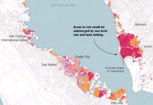
San Fransisco Bay Circa 2100

Abstract

by Manoochehr Shirzaei and Roland Bürgmann

The current global projections of future sea level rise are the basis for developing inundation hazard maps. However, contributions from spatially variable coastal subsidence have generally not been considered in these projections. We use synthetic aperture radar interferometric measurements and global navigation satellite system data to show subsidence rates of less than 2 mm/year along most of the coastal areas along San Francisco Bay. However, rates exceed 10 mm/year in some areas underlain by compacting artificial landfill and Holocene mud deposits. The maps estimating 100-year inundation hazards solely based on the projection of sea level rise from various emission scenarios underestimate the area at risk of flooding by 3.7 to 90.9%, compared with revised maps that account for the contribution of local land subsidence. Given ongoing land subsidence, we project that an area of 125 to 429 km2 will be vulnerable to inundation, as opposed to 51 to 413 km2 considering sea level rise alone.

The flood risks across the whole USA are seriously underestimated

The following paper covers all flood risk, not just the coasts, but inland and all the causes including sea level rise as well as flooding rivers and large precipitation events outside watersheds.

doi: 10.1088/1748-9326/aaac65

http://iopscience.iop.org/article/10.1088/1748-9326/aaac65/meta

“Estimates of present and future flood risk in the conterminous United States”
Oliver E J Wing ,  Paul D Bates, Andrew M Smith, Christopher C Sampson, Kris A Johnson, Joseph Fargione  and Philip Morefield

Environ. Res. Lett. 13 (2018) 034023

Wing et al. analyze flood risk in the US lower 48. Apparently 41 million are at risk rather than 13 million in current FEMA estimates.

WARNING: this paper specifically does not cover sea levels rise and increased precipitation.

“Our data show that the total US population exposed to serious flooding is 2.6–3.1 times higher than previous estimates, and that nearly 41 million Americans live within the 1% annual exceedance probability floodplain (compared to only 13 million when calculated using FEMA flood maps)”

“The analysis shows that 40.8 million people (13.3% of the population) are currently exposed to a 1 in 100 year (1% annual exceedance probability) fluvial or pluvial flood in the CONUS, which translates to a GDP exposure of $2.9 trillion (15.3% of total GDP)”

“This analysis indicates that previous estimates capture roughly one-third of the exposure identified in our 1 in 100 year floodplain.”

“It doesn’t take into account sea level rise and heavier rainfall expected to come along with climate change, so it likely underestimates the exposure, the authors warned.”
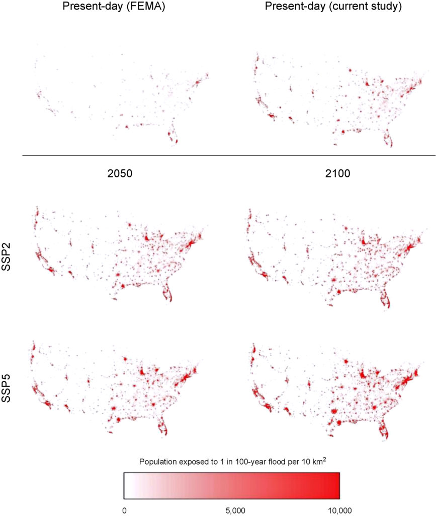
Revised Floodplain Map

https://www.houstonchronicle.com/news/houston-texas/houston/amp/28-million-Americans-live-in-flood-zones-and-12732279.php
Part of the study Who Pays For Flood Insurance?
bookmark_borderReal Estate and the Rising Sea Level

by Daniel Brouse

“Living near the water is incredibly appealing for people around the country, but it also comes with additional considerations for buyers and homeowners,” Zillow chief economist Svenja Gudell wrote in a new report. “Homes in low-lying areas are also more susceptible to storm flooding and these risks could be realized on a much shorter timeline as we have seen time and time again.”

Climate change is causing the sea level to rise. The effects are already being felt in places like the Jersey Shore. Atlantic City, N.J. ranked third in the top ten U.S. areas that experience nuisance flooding with a 682% surge since 1957.

“As relative sea level increases, it no longer takes a strong storm or a hurricane to cause flooding”said William Sweet, Ph.D., oceanographer at NOAA’s Center for Operational Oceanographic Products and Services (CO-OPS) and the report’s lead author. “Flooding now occurs with high tides in many locations due to climate-related sea level rise, land subsidence and the loss of natural barriers. The effects of rising sea levels along most of the continental U.S. coastline are only going to become more noticeable and much more severe in the coming decades, probably more so than any other climate-change related factor.”

“We’ve seen the enormous impact flooding can have on a city and its residents,” said Gudell. “It’s harder for us to think about it on a long-term timeline, but the real risks that come with rising sea levels should not be ignored until it’s too late to address them.”

The Zillow report found:

  • Coastal homes are threatened by the prospect of rising sea levels
  • More than $900 billion worth of U.S. residential real estate could be lost by a 6-foot rise in sea levels
  • The rise in water levels projected by 2100 could destroy 2 million homes

A CNBC analysis of the report said, “Of the nation’s largest cities, Miami, New York, Boston, Tampa and Fort Myers, Florida, have the highest volume of homes at risk of flooding. Los Angeles, Charleston, South Carolina, Houston and New Orleans are also in the top 20 markets at risk.”

Flood insurance is usually needed to obtain a mortgage for a property located in a flood zone. Flood insurance is the only insurance offered by the federal government that can be obtained by anybody. The National Flood Insurance Program (NFIP) is made available by the Federal Emergency Management Agency (FEMA).

The NFIP offers coverage for: 1) Building Property, up to $250,000, and 2) Personal Property (Contents), up to $100,000. The coverage is cumulative which means NFIP will pay out a maximum of $250,000 for the structure. If you make a claim for $100,000 and then sell the property, the next owner can only get insurance for up to $150,000.

The Zillow study found:

  • One-third (32 percent) of underwater homes would be valued in the bottom third nationally, meaning $123 billion in losses.
  • Two in five (39 percent) underwater homes would be valued in the top third nationally, translating to $597 billion in lost high-end real estate.
  • In rural and suburban areas, homes in the top value tier may face particular risk, while in urban areas homes in the bottom value tier are more likely to be affected.

MORE INFORMATION:
Top 5 Risks
How Do We Handle Flood Risk?
Senegal Forecasts Climate Change Changes
Biloxi-Chitimacha-Choctaw Indians Climate Change Refugees
Atlantic City Going Under
Biggert Waters Flood Insurance Reform Act of 2012
Flood Insurance Reform 2011
About Flood Insurance
Who Pays For Flood Losses?
Floodplain Maps Force Towns Into Tricky Waters
Head of the Federal Flood Insurance Program Resigns
Sacramento And FEMA Fight On Flood Insurance
Global Warming

bookmark_borderFlood Insurance and Rising Sea Levels

by Daniel Brouse

Q: Who pays for flood insurance?
A: The United States government, FEMA, covers losses for people that pay flood insurance premiums.

Q: Does your homeowners insurance policy cover you in the event of flooding?
A: No.

Flood insurance coverage is very limited. For instance, basements and belonging in a basement are not covered. Life-time coverage is also limited. If a property has a pay-out in the past, it will be applied to the maximum coverage of the life-time coverage.

As climate change causes extreme weather events and the sea level to rise, houses that are prone to flooding will find it harder and harder to get flood insurance. Without flood insurance, properties located in a flood plain become almost impossible to sell.

For years, the casinos in Atlantic City, NJ have had a plan to float the casinos and move them westward as the sea level rises. Shipping ports face a similar problem, but how can you move a port inland? Coastal areas will need to start a constant and progressive movement to higher ground.

Freddie Mac mortgage says, “Insurance is an essential component of real estate transactions, and flood insurance currently makes it possible to obtain loans for homes in areas of identified flood risk. However, some of the varied impacts of climate change—rising sea levels, changing rainfall and flooding patterns, increasing temperatures—may not be insurable. As a result, some important features of housing finance may have to change. The potential impact of these systemic changes on the financial system is difficult to visualize today.” (More from this article.)

Flood Insurance Index
Global Warming Index

bookmark_borderBillion People Face Global Flooding

The BBC reports, a British aid charity is warning that by 2060 more than a billion people worldwide will live in cities at risk of catastrophic flooding as a result of climate change. A study by Christian Aid says the US, China and India are among the countries most threatened. It says the Indian cities of Kolkata and Mumbai will be most at risk.

The eight most vulnerable cities on the list are all in Asia, followed by Miami in the US. The report urges governments to take action to reduce global warming and invest in disaster reduction programs.

Dr Alison Doig, the report’s author, told the BBC World Service that people living in large coastal cities were particularly at risk.

“I think it’s cities like Kolkata, Dakar, the big mega-cities of the south and the emerging economies where the people are most vulnerable to exposure to sea-level rises and to higher rain events,” she said.

“Flooding in these cities can cause massive damage, but can also threaten life.”

“The whole of Florida is totally vulnerable,” she said.

“It is so low-lying, it is virtually swampland reclaimed. So significant climate change… raising water half to a full metre this century, will take out an awful lot of Florida and a significant amount of Miami.”

The study says that the priority should be to rapidly reduce carbon emissions and limit temperature increase by switching from fossil fuels to low-carbon energy.

It says vulnerable communities must be helped by better protecting homes and livelihoods.

The study also calls for international systems to help communities recover from devastating storms and floods.

Dr Doig warned that Florida was likely to suffer extensive flooding.

bookmark_borderSixth 1000-year Rain Since 2010

Human induced climate change is causing more volatile and extreme weather events. The rain in South Carolina was the 6th 1000-year rain since 2010.

We are not saying that the Earth’s temperature is just going to rise. In general, as energy is added to a system, the fluctuations in the system increase. So, we expect more storms, more droughts, more wildfires, more floods, more fluctuations of all kinds. What we are saying is that weather conditions will become more volatile due to the impact of humans. (Extreme Weather Events)

— S. Mukherjee & D. Brouse (2004)

So many “1-in-1,000 year” rainfalls is unprecedented, said meteorologist Steve Bowen of Aon Benfield, a global reinsurance firm. “We have certainly had our fair share in the United States in recent years, and any increasing trend in these type of rainfall events is highly concerning,” Bowen said.

A “1-in-1,000 year event” means that there’s a 1 in 1,000 (or 0.1% chance) of it happening in any given year in a given location, the National Oceanic and Atmospheric Administration said.

“Rising water from flooding can carry viruses, bacteria, chemicals and other submerged objects picked up as it moves through stormwater systems, across industrial sites, yards, roads and parking lots,” the South Carolina Emergency Response Team said.

bookmark_borderRecord-Setting Rain

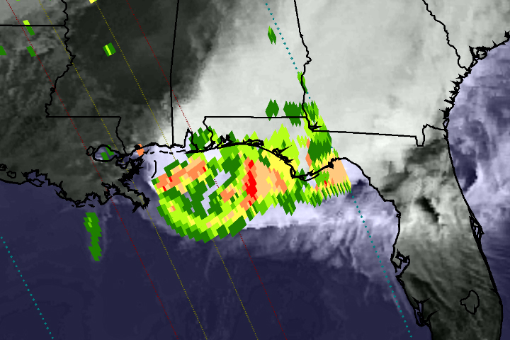
On April 29, 2014, the Global Precipitation Measurement (GPM) satellite observed the heavy rain that produced floods near Pensacola, Florida. The National Weather Service reported record-setting rainfall totals of more than 380 mm (15 inches) in Pensacola from the storm system that inundated the southeastern and eastern United States in recent days.

This image shows GPM Microwave Imager (GMI) rainfall estimates (green to red) superimposed on infrared observations (showing clouds and land) over the southeastern United States. Because the GPM satellite was launched only two months ago, the rainfall-estimation algorithms are currently undergoing a checkout period. For this reason, the scale indicates only qualitative information with green for light rain and red for heavy rain.

This GPM data was collected during a single satellite overpass shortly after noon local time, providing a snapshot of rain rates at that time. The outer blue dotted lines show the width of observations from the GMI instrument, while the two inner lines represent the area measured by the Ka-band (inner lines) and Ku-band (outer lines) of the Dual-Frequency Precipitation Radar. Once the radar data become available, they will provide a three-dimensional view of rain, ice, and snow in the atmosphere.

Extreme Weather
Extreme Weather

bookmark_borderDeath Toll in Indian Monsoon Flooding

The severe weather event in India has a rising death toll. Currently at 500, it is expected to rise to over 1,000. More than 60,000 people have been stranded.

” Uttrakhand state Chief Minister Vijay Bahguna said 556 bodies have been noticed buried deep in slush and the army was trying to recover them. He spoke to CNN-IBN television channel on Friday.

Rescuers also Friday found 40 bodies floating in the Ganges near Haridwar, a Hindu holy city, said police officer Rajiv Swaroop.

Bahguna said the eventual toll would be in the hundreds. Rakesh Sharma, another state official, had said Thursday the death toll might reach the thousands but the exact figure would not be known until the entire region is checked.

Home Minister Sushilkumar Shinde told reporters in New Delhi that 34,000 people have been evacuated so far and another 50,000 were stranded in the region. Roads and bridges were washed away by the floods or blocked by debris.”

More information on the effects of global warming and climate change.

bookmark_borderLarge Storm System in Eastern U.S.

The large storm in the eastern U.S. is visible in the satellite image below, taken by GOES East at 1715Z (12:15 EST) today.

The storm system continues to bring significant rainfall to Indiana and Michigan, where Flood Warnings and Advisories are in effect. The bulk of the precipitation has ended in Kentucky and southern Indiana, but several Flood Warnings and advisories continue. Central Kentucky and southern Indiana have received 2.5 to 5 inches of rainfall over the past 2 days. Additional rainfall amounts of 1 to 2 inches are possible in northern Indiana, northwest Ohio, and central and eastern lower Michigan before changing over to snow late this afternoon and evening for the first significant snowfall of the season. Winter Storm Watches and Warnings have been posted for northern Indiana, northwest Ohio, and central and southeast lower Michigan, where 4 to 8 inches of snow will be possible, with locally higher amounts possible if rain changes to snow earlier than expected.

The large storm in the eastern U.S. is visible in the satellite image below, taken by GOES East at 1715Z (12:15 EST) today.

The storm system continues to bring significant rainfall to Indiana and Michigan, where Flood Warnings and Advisories are in effect. The bulk of the precipitation has ended in Kentucky and southern Indiana, but several Flood Warnings and advisories continue. Central Kentucky and southern Indiana have received 2.5 to 5 inches of rainfall over the past 2 days. Additional rainfall amounts of 1 to 2 inches are possible in northern Indiana, northwest Ohio, and central and eastern lower Michigan before changing over to snow late this afternoon and evening for the first significant snowfall of the season. Winter Storm Watches and Warnings have been posted for northern Indiana, northwest Ohio, and central and southeast lower Michigan, where 4 to 8 inches of snow will be possible, with locally higher amounts possible if rain changes to snow earlier than expected.

Get the latest forecasts, watches and warnings from your local NWS Weather Forecast Office at http://www.weather.gov/.

Latest Storm Summary from the NWS Hydrometeorological Prediction Center:
http://www.hpc.ncep.noaa.gov/discussions/nfdscc3.html

High-Res version of image from NOAA’s Environmental Visualization Lab:
http://www.nnvl.noaa.gov/images/high_resolution/900_20111129-eastcoast.jpg

· · Share · about an hour ago ·

bookmark_borderFlooding From Japan’s Earthquake Tsunami

Flooding From Tsunami
Japan's Coast Before the Earthquaker

NASA’s Terra satellite’s first view of northeastern Japan in the wake of a devastating earthquake and tsunami reveal extensive flooding along the coast. The Moderate Resolution Imaging Spectroradiometer (MODIS) acquired the top image of the Sendai region on March 12, 2011, at 10:30 a.m. The lower image, taken by Terra MODIS on February 26, 2011, is provided as a point of reference.

Water is black or dark blue in these images. It is difficult to see the coastline in the March 12 image, but a thin green line outlines the shore. This green line is higher-elevation land that is above water, presumably preventing the flood of water from returning to the sea. The flood indicator on the lower image illustrates how far inland the flood extends.

Both images were made with infrared and visible light, a combination that increases the contrast between muddy water and land. Plant-covered land is green, while snow-covered land is pale blue. Clouds are white and pale blue. The paved surfaces in the city of Sendai colors it brown.

MODIS detected a fire burning near the shore north of Sendai. The fire is marked with a red box. It is also surrounded by floods.

The photo-like true-color image acquired a few hours later shows plumes of sediment washed into the ocean along the coast and a dark plume of smoke near Sendai. Both images are from the MODIS Rapid Response System, which provides twice-daily images of Japan.

NASA images courtesy the MODIS Rapid Response Team at NASA GSFC. Caption by Holli Riebeek.

Instrument: Terra – MODIS