bookmark_borderOne Trillion Ton Iceberg

By Daniel Brouse

An iceberg weighing over one trillion tons (about the size of Delaware) broke off Antarctica. “Antarctica contains 90% of the world’s fresh water as ice. If all the ice melts, sea levels will rise by 60 meters (200 feet). The sea ice melting doesn’t raise the sea level as the ice is already floating.” (Brouse / Mukerhjee 2017)

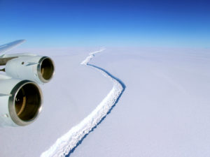
Antarctica Larsen C Ice Crack

The new iceberg was already floating, so it won’t have much effect on the sea level; however, it may a destabilizing effect on the rest of Antarctica. “One warning sign that a dangerous warming is beginning in Antarctica, will be a breakup of ice shelves in the Antarctic Peninsula just south of the recent January 0C isotherm; the ice shelf in the Prince Gustav Channel on the east side of the peninsula, and the Wordie Ice Shelf; the ice shelf in George VI Sound, and the ice shelf in Wilkins Sound on the west side.” (John Mercer 1978)

In January of 2017, a UK research team discovered a huge increase in a massive 90-mile crack running through the Larsen C shelf (pictured to the right). In June of 2017, the crack broke and a huge iceberg was created.

Ice Shelf Animation By Doyle Rice and Jim Sergent

See: Antarctica And Rising Sea Level

bookmark_borderAntarctica And Rising Sea Level

by Daniel Brouse and Sidd Mukherjee

The U.N. weather agency said the Antarctic peninsula has set a heat record of 63.5° Fahrenheit (17.5 degrees Celsius) on March 24, 2015. In March of 2017, there is about 10% less sea ice in Antarctica than the previous record minimum. “One would probably say that the old record was obliterated,” said Jan Lieser, a sea ice scientist at the Hobart-based Antarctic Climate and Ecosystems Co-operative Research Centre.

Antarctica contains 90% of the world’s fresh water as ice. If all the ice melts, sea levels will rise by 60 meters (200 feet). The sea ice melting doesn’t raise the sea level as the ice is already floating. The ice that is above land is a different story.

The problem with the ice in Antarctica is that much of the ice is on land. As the land ice melts or falls into the ocean the sea level rises. Compounding the problem is the elevation of the land. Over the centuries the weight of the ice has caused the land to sink. As the ocean temperature warms, water is starting to seep in under the ice. The warm water under the ice sheet is accelerating the destabilization of the sheet.

“There was a physicist called John Mercer at the Byrd polar research center here at Ohio State, who was warning of WAIS collapse as early as 1968,” said Sidd Mukherjee research physicist at Ohio State University.

Then in 1978 Mercer wrote:
“One warning sign that a dangerous warming is beginning in Antarctica, will be a breakup of ice shelves in the Antarctic Peninsula just south of the recent January 0C isotherm; the ice shelf in the Prince Gustav Channel on the east side of the peninsula, and the Wordie Ice Shelf; the ice shelf in George VI Sound, and the ice shelf in Wilkins Sound on the west side. ”

Each of these shelves is in retreat or gone. Mercer was more correct than he knew. Recent work by Bassis et al. shows that ice shelves collapse shortly after the temperature of the top surface exceeds the 0C melting point through a process called hydrofracture, where water filled crevasses penetrate all the way to the bottom of the shelf. Bassis et al. also pointed out that a cliff of ice higher than 100m (300 ft) is unstable against collapse. These cliff heights are attained where the bedrock is more than 1Km below sea level, as in large parts of WAIS. When the shelves melt leaving cliffs behind which directly face the ocean they will collapse along large sections of WAIS. The more frightening estimates for WAIS deglaciation are on the order of centuries, rather than millennia, indeed decadal time scales cannot be entirely ruled out. We know from past records that sea level can rise as fast as a foot a decade and maintain that rate for five hundred years. Such rates of sea level rise will destroy most coastal cities of the world, since coastal infrastructure cannot be moved inland or protected by seawalls quickly enough.

Antarctica Larsen C Ice Crack

In January of 2017, a UK research team discovered a huge increase in a massive 90-mile crack running through the Larsen C shelf (pictured to the right). The crack might soon split off a chunk of ice the size of Delaware. Larson C is part of Eastern Antarctic. Larson A and Larson B have already collapsed.

The Western Antarctic Ice Sheet (WAIS) is the segment of the continental ice sheet that covers West Antarctica. The melting of the West Antarctic ice sheet alone would raise global sea levels by more than 20 feet, according to researchers from the British Antarctic Survey. Over the last several years, WAIS has become unstable. A 2016 study by Khazendar, Rignot, and others adds to the mounting evidence that the threshold for an irreversible disintegration has begun.

“It’s generally accepted that it’s no longer a question of whether the West Antarctic Ice Sheet will melt, it’s a question of when,” said leader Ian Howat, associate professor of earth sciences at Ohio State in a 2016 study published in the journal Geophysical Research Letters. “This kind of rifting behavior provides another mechanism for rapid retreat of these glaciers, adding to the probability that we may see significant collapse of West Antarctica in our lifetimes.”

Ice calving is the breaking of ice chunks from the edge of a glacier. Calving causes mini-tsunamis daily in Antarctica.

The Thwaites Glacier is of great concern. Thwaites Glacier is an unusually broad and fast Antarctic glacier flowing into Pine Island Bay. As the warming temperature of sea water melts the bottom of the glacier, it allows water to enter underneath the ice. A University of Washington study determined that the Thwaites Glacier will gradually melt, leading to an irreversible collapse over the next 200 to 1000 years.

bookmark_borderChilling Facts About Antarctica

by Daniel Brouse for The Human Induced Climate Change Experiment

A 1,930 square mile chunk of ice is getting ready to fall off a glacier in Antarctica. In December 2016, a large crack appeared in part of Larsen C ice shelf.

Global warming is increasing the temperature of the ocean water even more than the temperature of the air; however, Andrew Fleming (sensing manager at the British Antarctic Survey) said the ice was being thawed both by warmer air above and by warmer waters below the ice.

The Larsen B ice shelf has already been severely impacted. “Larsen B shattered like car safety glass into thousands and thousands of pieces,” Fleming said. “It disappeared in the space of about a week.”

“If it doesn’t go in the next few months, I’ll be amazed,” project leader Prof Adrian Luckman said. “There hasn’t been enough cloud-free Landsat images but we’ve managed to combine a pair of Esa Sentinel-1 radar images to notice this extension, and it’s so close to calving that I think it’s inevitable.”

bookmark_borderAntarctica: Melting Glacier Could See Sea Levels to Rise by 6 Feet

In a new study by Imperial College of London, “current rates of climate change could trigger instability in a major Antarctic glacier, ultimately leading to more than 2m of sea-level rise.”

“The evidence coming together is painting a picture of East Antarctica being much more vulnerable to a warming environment than we thought,” said Professor Martin Siegert, Co-Director of the Grantham Institute at Imperial College London. “This is something we should worry about. Totten Glacier is losing ice now, and the warm ocean water that is causing this loss has the potential to also push the glacier back to an unstable place.”

“Totten Glacier is only one outlet for the ice of the East Antarctic Ice Sheet, but it could have a huge impact. The East Antarctic Ice Sheet is by far the largest mass of ice on Earth, so any small changes have a big influence globally.”

bookmark_borderAntarctica High

The Weather Underground reports Antarctica hit a record high temperature. Antarctica may have experienced its warmest day ever recorded on Tuesday, with the temperature reading of 63.5°F, reports The Weather Underground.

Tuesday’s record high temperature follows another high reading of 63.3°F set just the day before. Until this week’s heat wave, the highest-known recorded temperature on the continent was 62.6°F back in 1976.

The Antarctic Peninsula where the readings were made “is one of the fastest warming spots on Earth,” reports The Weather Undergound. The website cites studies from 2012 that show the world is warming at a quickening pace.

Five nations and territories have tied or hit all-time high temperature records so far this year.

bookmark_borderAntarctica Ice Loss

Warm Ocean Currents Cause Majority of Ice Loss from Antarctica

WASHINGTON, DC (USA) — Warm ocean currents attacking the underside of ice shelves are the dominant cause of recent ice loss from Antarctica, a new study using measurements from NASA’s Ice, Cloud, and land Elevation Satellite (ICESat) revealed.

An international team of scientists used a combination of satellite measurements and models to differentiate between the two known causes of melting ice shelves: warm ocean currents thawing the underbelly of the floating extensions of ice sheets and warm air melting them from above. The finding, published today in the journal Nature, brings scientists a step closer to providing reliable projections of future sea level rise.

The researchers concluded 20 of the 54 ice shelves studied are being melted by warm ocean currents. Most of these are in West Antarctica, where inland glaciers flowing down to the coast and feeding into these thinning ice shelves have accelerated, draining more ice into the sea and contributing to sea-level rise. This ocean-driven thinning is responsible for the most widespread and rapid ice losses in West Antarctica and the majority of Antarctic ice sheet loss during the period studied.

“We can lose an awful lot of ice to the sea without ever having summers warm enough to make the snow on top of the glaciers melt,” said the study’s lead author Hamish Pritchard of the British Antarctic Survey in Cambridge, United Kingdom. “The oceans can do all the work from below.”

To map the changing thickness of almost all the floating ice shelves around Antarctica, the team used a time series of 4.5 million surface height measurements taken by a laser instrument mounted on ICESat from October 2003 to October 2008. They measured how the ice shelf height changed over time and ran computer models to discard changes in ice thickness because of natural snow accumulation and compaction. The researchers also used a tide model that eliminated height changes caused by tides raising and lowering the ice shelves.

“This study demonstrates the power of space-based, laser altimetry for understanding Earth processes,” said Tom Wagner, cryosphere program scientist at NASA Headquarters in Washington.” Coupled with NASA’s portfolio of other ice sheet research using data from our GRACE mission, satellite radars and aircraft, we get a comprehensive view of ice sheet change that improves estimates of sea level rise.”

Previous studies used satellite radar data to measure the evolution of ice shelves and glaciers, but laser measurements are more precise in detecting changes in ice shelf thickness through time. This is especially true in coastal areas. Steeper slopes at the grounding line, where floating ice shelves connect with the landmass, cause problems for lower-resolution radar altimeters.

ICESat was the first satellite specifically designed to use laser altimetry to study the Earth’s polar regions. It operated from 2003 to 2009. Its successor, ICESat-2, is scheduled for launch in 2016.

“This study demonstrates the urgent need for ICESat-2 to get into space,” said Jay Zwally, ICESat project scientist at NASA’s Goddard Space Flight Center in Greenbelt, Md. “We have limited information on the changes in polar regions caused by climate change. Nothing can look at these changes like satellite measurements do.”

The new research also links the observed increase in melting that occurs on the underside of a glacier or ice shelf, called basal melt, and glacier acceleration with changes in wind patterns.

“Studies have shown Antarctic winds have changed because of changes in climate,” Pritchard said. “This has affected the strength and direction of ocean currents. As a result warm water is funnelled beneath the floating ice. These studies and our new results suggest Antarctica’s glaciers are responding rapidly to a changing climate.”

A different picture is seen on the Antarctic Peninsula, the long stretch of land pointing towards South America. The study found thinning of the largest ice shelf on the peninsula can be explained by warm summer winds directly melting the snow on the ice shelf surfaces. The patterns of widespread ocean-driven melting and summer melting on the Antarctic Peninsula can be attributed to changing wind patterns.

The study was carried out by an international team from the British Antarctic Survey, Utrecht University in Utrecht, Netherlands, the University of California in San Diego and the non-profit research institute Earth and Space Research in Corvallis, Ore.

For more information, a visualization and related imagery, visit:

http://www.nasa.gov/topics/earth/features/currents-ice-loss.html

For more information about ICESat and ICESat-2, visit:

http://icesat.gsfc.nasa.gov