bookmark_borderOccupy Philly Fringe Movement Arrested

Comcast Building, Philadelphia, PA
November 2, 2011
by Daniel Brouse

Individuals that identified themselves as being with Occupy Philly got arrested at the Comcast building. It is believed they invaded private property and/or committed illegal trespass.

The Philadelphia Police were patient and cordial as protestors were put into paddy wagons.

bookmark_borderDonations Of Things

http://www.livestream.com/occupyphiladelphia

www.livestream.com

OccupyPhiladelphia on Livestream. LiveStreaming from Occupy Philadelphia – Watch live streaming Internet TV. Broadcast your own live streaming videos, like OccupyPhiladelphia in Widescreen HD. Livestream, Be There.
· · Share · 10 hours ago
    • Daniel Brouse mailing address for physical donations (so i’m told, coats, hats, etc.): Occupy Philly, 1229 Chestnut St., PO Box PMB248, Philadelphia, PA 19107

bookmark_borderOccupy Philly Thank You Notes

bookmark_borderBurn Scar

Burn scar from fires in Minnesota

Nearly two months after being ignited by lightning, the Pagami Creek Fire in northern Minnesota was nearly contained when Landsat-5 acquired this image on October 10, 2011. Since August 18, the fire has been burning in the Boundary Waters Canoe Area Wilderness in Superior National Forest. As of October 11, the fire had burned 92,682 acres and was 82 percent contained. Apart from a faint hint of smoke, there is little sign of current fire activity in the image. The burned forest, however, is charcoal-colored, in contrast to the green forest around it.

  1. Reference

  2. InciWeb. (2011, October 11). Pagami Creek Fire. Accessed October 11, 2011.

NASA Earth Observatory image created by Jesse Allen and Robert Simmon, using Landsat data provided by the United States Geological Survey. Caption by Holli Riebeek.

Instrument:
Landsat 5 – TM

bookmark_borderHurricane Irene

Hurricane Irene
Hurricane Irene

Tropical Storm Conditions Spreading Northward Along Delmarva Coast

Published: Sat, 27 Aug 2011 10:58:54 EDT
At 11:00 a.m. EDT, the center of Hurricane Irene was located near latitude 35.2 north, longitude 76.4 west, or about 100 miles southwest of Cape Hatteras, N.C. Irene is moving toward the north-northeast near 15 mph and this general motion is expected to continue for the next 24 hours. The center of Irene is forecast to move across northeastern North Carolina this afternoon before moving near or over the Mid-Atlantic coast tonight and over southern New England on Sunday. Maximum sustained winds remain near 85 mph, with higher gusts. Irene is a Category One hurricane. Slight weakening is forecast as Irene crosses eastern North Carolina, but Irene is forecast to remain near hurricane strength as it moves near or over the Mid-Atlantic states and approaches New England. For storm information specific to your area in the U.S., please monitor products issued by your local NWS forecast office.

from noaa.gov

bookmark_borderNortheastern United States Earthquake

Magnitude 5.9 – VIRGINIA
2011 August 23 17:51:03 UTC

U.S. Geological Survey
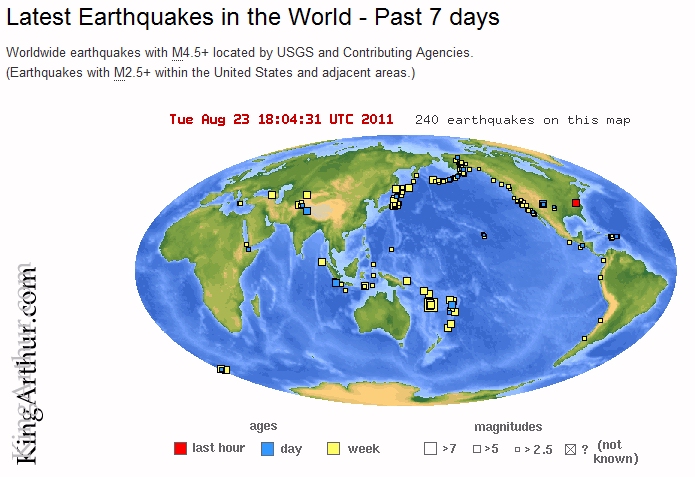
West-Chester-Earthquake

Earthquake Details

This event has been reviewed by a seismologist.

Magnitude 5.9
Date-Time

Tuesday, August 23, 2011 at 17:51:03 UTC
Tuesday, August 23, 2011 at 01:51:03 PM at epicenter

Location 37.975°N, 77.969°W
Depth 1 km (~0.6 mile) (poorly constrained)
Region VIRGINIA
Distances

6 km (4 miles) SSE (152°) from Louisa, VA
6 km (4 miles) SW (236°) from Mineral, VA
26 km (16 miles) SE (133°) from Gordonsville, VA
66 km (41 miles) NW (318°) from Richmond, VA
134 km (83 miles) SW (219°) from Washington, DC

Location Uncertainty horizontal +/- 10.9 km (6.8 miles); depth +/- 7.4 km (4.6 miles)
Parameters NST=390, Nph=390, Dmin=57.9 km, Rmss=1.17 sec, Gp= 47°,
M-type=regional moment magnitude (Mw), Version=6
Source

Magnitude: USGS NEIC (WDCS-D)
Location: USGS NEIC (WDCS-D)

Event ID usc0005ild

Felt in West Chester, PA.

bookmark_borderFunky Fontana

Funky Fontana Band at Alibis West Chester 1


bookmark_borderRob Dickenson, Jim Littman and Michael Rast