Global warming is exactly that—global. These two videos of the 2026 wildfire season provide a striking example.
The first video shows wildfire smoke spreading across North America. The second follows that smoke as it is transported across the atmosphere and circulates around the globe, reaching the UK and Europe.
The second video also captures smoke from wildfires burning across Spain, France, and Greece, along with massive fires in the Siberian forests.
Wildfire smoke does not recognize national borders—and neither does climate change. What happens in one part of the world can affect the atmosphere, climate, and air quality thousands of miles away.
Changing Atmospheric Moisture Transport, Precipitation Intensity, and the Redistribution of Water
Abstract
Climate warming is altering the atmospheric hydrologic cycle in ways that extend beyond changes in average precipitation. This paper examines the hypothesis that warming is increasing atmospheric moisture residence time and transport distance while simultaneously intensifying precipitation and, in some regions, producing more spatially concentrated and temporally episodic rainfall. The resulting hydrologic regime may be characterized by heavier precipitation events, longer intervening dry periods, declining snowpack, and increasing disparities in water availability.
Evidence from atmospheric moisture-tracking, precipitation observations, climate modeling, and snowpack records supports substantial portions of this hypothesis. A 2026 analysis of 35 years of atmospheric reanalysis data found statistically significant increases in moisture-transport distance and residence time across portions of the southwestern United States and southern Great Plains. In some watersheds, moisture traveled approximately 50–80 km farther and remained in the atmosphere 2–4 hours longer than in earlier decades.
At the same time, heavy precipitation has increased across the contiguous United States since the 1950s, particularly in the Northeast and Midwest. Other research indicates that warming can increase precipitation intensity while reducing the size or duration of individual precipitation systems in some seasons and regions. Meanwhile, observations across the western United States show longer and more variable dry periods and substantial declines in snowpack.
The evidence therefore supports a modified version of the proposed hypothesis: warming is not generally causing atmospheric moisture to travel shorter distances before precipitation. Instead, warming is increasing atmospheric moisture residence time and transport distance while altering the timing, intensity, duration, and spatial distribution of precipitation. The resulting combination can produce a more episodic hydrologic cycle in which extreme precipitation and flooding coexist with longer dry intervals, drought, earlier snowmelt, and declining water-storage capacity.
1. Introduction
The hydrologic cycle is often described in terms of precipitation totals: how much rain or snow falls over a particular location during a given period. This approach, while useful, can obscure an important characteristic of the climate system—the distribution of precipitation in space and time.
Two regions could receive identical annual precipitation while experiencing radically different hydrologic conditions. One might receive moderate precipitation distributed throughout the year. The other might experience prolonged dry periods punctuated by a few exceptionally intense storms.
The consequences are very different.
The first regime promotes relatively consistent soil moisture, groundwater recharge, snow accumulation, and streamflow. The second can produce the seemingly contradictory combination of flooding and drought: intense storms generate rapid runoff and flooding, while the longer intervals between storms allow soils and vegetation to dry and reduce groundwater and snowpack storage.
This raises a fundamental question:
Is climate warming changing not merely how much precipitation occurs, but how atmospheric moisture is transported and how precipitation is distributed across time and space?
The hypothesis examined here is:
Climate warming is altering the atmospheric hydrologic cycle by increasing atmospheric moisture residence time and transport distance while simultaneously increasing precipitation intensity and, in some regions, reducing the spatial extent and duration of individual precipitation events. This may produce a more episodic hydrologic cycle characterized by heavier flooding when precipitation occurs, longer intervening dry periods, declining snowpack, and greater spatial disparities in water availability.
Recent research provides an unusually strong opportunity to test this hypothesis because scientists can now combine decades of atmospheric reanalysis with Lagrangian moisture tracking, precipitation observations, radar data, climate models, and long-term snowpack records.
2. Atmospheric Moisture Is Traveling Farther
One of the most direct tests of the hypothesis is whether scientists can actually measure changes in the distance atmospheric moisture travels before becoming precipitation.
Until recently, this was difficult to quantify over sufficiently long periods. Modern atmospheric reanalysis and moisture-tracking techniques now make it possible.
A 2026 study published in Geophysical Research Letters analyzed 35 years of reanalysis data and tracked atmospheric moisture contributing to precipitation across watersheds in the contiguous United States. The study found statistically significant trends in both the length scale of moisture recycling and the atmospheric residence time of water vapor across portions of the Southwest and southern Great Plains.
In some regions, moisture now travels approximately:
50–80 km farther before precipitation
2–4 hours longer in the atmosphere
than it did approximately 35 years earlier.
This is an important result because it directly confirms that moisture transport distance can be measured over decades and that measurable changes are occurring.
The study also found a shift in moisture sources. On average, evaporation from terrestrial surfaces has decreased while the contribution from oceanic evaporation has increased in the examined regions. The researchers concluded that moisture over land is traveling farther and remaining in the atmosphere longer before precipitation.
This result is consistent with earlier theoretical work on atmospheric water-vapor residence time. A major review in Nature Reviews Earth & Environment found that the global mean residence time of atmospheric water vapor is approximately 8–10 days, although the median is shorter because residence times have a highly skewed distribution. The review concluded that anthropogenic warming is expected to increase atmospheric water-vapor residence time by approximately 3–6% per °C of warming, thereby increasing the distance moisture travels between evaporation and precipitation.
Result
The first component of the hypothesis is strongly supported.
Atmospheric moisture is not generally traveling a shorter distance before precipitation. Evidence instead indicates that, in important regions, warming is increasing moisture residence time and transport distance.
3. Why a Warmer Atmosphere Changes Moisture Transport
The physical mechanism is straightforward.
A warmer atmosphere can contain more water vapor. The Clausius–Clapeyron relationship indicates that the saturation vapor pressure of air increases by approximately 7% per °C of warming near Earth’s surface.
But atmospheric moisture does not simply remain where it evaporates.
It is transported by atmospheric circulation. As moisture remains available for longer periods before precipitation, it can be carried farther from its original source.
This creates an important distinction between moisture-source distance and precipitation footprint.
A storm can receive moisture from farther away while simultaneously depositing a large portion of that moisture over a relatively small geographic area.
Consequently:
Longer moisture transport does not necessarily mean broader precipitation.
This distinction resolves an apparent contradiction in the original hypothesis.
4. Increasing Precipitation Intensity
The second major component of the hypothesis concerns precipitation intensity.
Here the observational evidence is strong.
The U.S. Environmental Protection Agency reports that heavy precipitation events have become more frequent across the contiguous United States since the 1950s, with particularly strong increases in the Northeast and Midwest. The EPA also concludes that human-caused warming has contributed to the increase.
The physical mechanism is again related to atmospheric moisture.
When additional water vapor is available to a storm, precipitation intensity can increase substantially. Consequently, precipitation totals averaged over a month or year can conceal a major change in event intensity.
For example, suppose a region historically receives 40 inches of precipitation annually.
That 40 inches could theoretically occur as:
40 inches ÷ 365 days = relatively frequent moderate precipitation
or instead as:
long dry intervals + several extremely heavy storms.
The annual total might be similar while the hydrologic consequences are dramatically different.
The second regime produces more runoff, erosion, flash flooding, infrastructure stress, and potentially less effective groundwater recharge.
5. Evidence for More Spatially Concentrated Precipitation
The hypothesis becomes more complicated when spatial extent is considered.
Research does not support a universal rule that precipitation systems are always becoming smaller.
Instead, the response varies according to storm type, season, geography, and atmospheric circulation.
A modeling study examining precipitation characteristics over the contiguous United States found that warming can increase precipitation intensity while reducing storm size. In its simulations, summertime storms became more intense but smaller, while winter storms also tended toward reduced spatial extent and, in some cases, fewer and shorter-duration events.
Other research reaches a more nuanced conclusion.
A study of precipitation-event spatial extent using high-resolution regional climate models found that the response depends upon the size of the precipitation system. Larger systems can become more frequent and larger, while smaller systems can decrease in number.
This means the most defensible conclusion is not:
All storms are becoming smaller.
Rather:
Warming is changing the relationship between precipitation intensity, spatial extent, storm organization, and duration. Some precipitation regimes are becoming more intense and spatially concentrated even as other large-scale systems may expand.
That distinction is essential.
6. Shorter Storms Can Produce Longer Dry Intervals
The temporal component of the hypothesis may be even more important than storm size.
A study of precipitation characteristics under warming found that, in model simulations, increasing precipitation intensity was accompanied by changes in storm frequency, size, and duration. In particular, summertime precipitation systems became more intense and smaller, while winter systems also showed reductions in size and, in some cases, duration and frequency.
Meanwhile, observations provide direct evidence of increasing dry intervals in parts of the United States.
A USGS-supported study examined daily precipitation records from 337 long-term weather stations across the western United States from 1976–2019. It found reduced annual precipitation across much of the region, increasing precipitation variability, and increasing duration of dry intervals. The mean dry interval increased approximately 0.6 days per decade, while the longest dry interval increased approximately 2.4 days per decade.
This is precisely the type of change expected from a more episodic hydrologic cycle.
The atmosphere does not necessarily become uniformly drier.
Instead, precipitation can become less evenly distributed.
7. The Emerging Pattern: Flooding and Drought
The combined evidence suggests that the most important change may not be a simple shift toward “more rain” or “less rain.”
It may be a shift toward greater hydrologic variability.
A simplified conceptual model is:
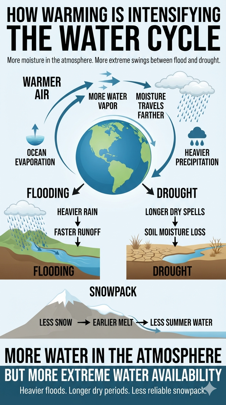
Warming → Greater atmospheric moisture capacity → Longer moisture residence time → Longer moisture transport pathways → Greater moisture availability to precipitation systems → More intense precipitation → Greater runoff and flood potential
Meanwhile:
Longer intervals between precipitation events → Greater evapotranspiration and soil-moisture loss → Longer dry periods → Drought stress
Greater runoff and flood potential
This produces an apparent paradox:
More water falling during individual storms can coexist with less water available between storms.
The distinction is between precipitation flux and water storage.
A very intense storm can move enormous quantities of water through a watershed without necessarily increasing long-term water availability proportionally.
If rainfall arrives faster than soil infiltration capacity, a larger fraction can become surface runoff. That water rapidly enters streams and rivers rather than being retained in soils or replenishing groundwater.
Thus:
More precipitation ≠ more available water.
8. Snowpack: The Natural Water Reservoir Is Shrinking
Snowpack introduces another critical component.
Mountain snowpack functions as a natural seasonal reservoir, storing winter precipitation and releasing it gradually during spring and summer.
As temperatures rise, precipitation increasingly falls as rain rather than snow in marginal snow zones. Existing snow also melts earlier.
NOAA reports that average spring snowpack across the western United States declined by approximately 20% between 1955 and 2020.
The significance extends beyond skiing or mountain ecology.
Snowpack controls the timing of water delivery to downstream watersheds.
A precipitation regime that shifts from:
winter snow → spring melt → summer runoff
toward:
winter rain → immediate runoff
loses part of the natural storage function of the mountain snowpack.
This creates a second form of hydrologic episodicity.
Instead of storing water for future months, precipitation is increasingly capable of moving rapidly through the watershed.
9. A Changing Geography of Water
The 2026 moisture-transport research adds another dimension to the problem.
If the source of precipitation changes, the hydrologic security of a region can become increasingly dependent upon atmospheric processes occurring far beyond its borders.
The study found that portions of the United States are receiving moisture that has traveled farther through the atmosphere and that a greater share of the moisture is associated with oceanic rather than terrestrial sources.
This means the traditional concept of a watershed may be insufficient for understanding future water security.
A watershed describes where water flows after it reaches the surface.
Atmospheric moisture tracking describes where that water came from before it arrived.
Climate change can alter both the atmospheric and terrestrial portions of this cycle.
Consequently, two regions receiving similar annual precipitation totals may have substantially different water-security risks depending on:
moisture-source location,
atmospheric transport distance,
residence time,
precipitation intensity,
storm footprint,
dry-period duration,
snowpack,
evapotranspiration,
soil infiltration,
groundwater recharge,
and runoff.
10. Evaluation of the Hypothesis
The evidence can now be evaluated component by component.
Hypothesis component
Evidence
Assessment
Atmospheric moisture residence time is increasing
Theory + observations
Supported
Moisture transport distance is increasing
35-year U.S. moisture-tracking study
Supported regionally
Oceanic moisture contribution is increasing in some U.S. regions
2026 moisture-tracking study
Supported regionally
Heavy precipitation is increasing
Long-term U.S. observations
Strongly supported
Precipitation intensity is increasing with warming
Observational/model evidence
Strongly supported
Precipitation spatial extent is decreasing
Modeling/observational evidence
Partially supported; highly regional
Precipitation duration is decreasing
Model evidence
Partially supported; storm-dependent
Dry intervals are increasing
Western U.S. observations
Supported regionally
Snowpack is declining
Long-term observations
Strongly supported in western U.S.
Water availability is becoming more spatially variable
Multiple lines of evidence
Supported
The hypothesis therefore survives testing, but with an important modification.
The evidence does not support a universal reduction in moisture transport distance. It supports the opposite.
Nor does it establish that every precipitation event is becoming smaller or shorter.
Instead, the evidence supports a broader and more physically consistent hypothesis:
Anthropogenic warming is increasing atmospheric moisture availability and, in many regions, atmospheric moisture residence time and transport distance. At the same time, warming is increasing precipitation intensity and altering storm size, duration, frequency, and spatial organization. These changes can increase precipitation variability, producing heavier precipitation and flooding in some periods while lengthening dry intervals, reducing snowpack, and increasing water scarcity in others.
11. Implications for Flood Risk
This distinction has major implications for flood-risk assessment.
Traditional infrastructure design often relies heavily on historical precipitation statistics.
But if precipitation characteristics are changing, the historical distribution may no longer be stationary.
A watershed can experience:
longer dry periods
followed by
more intense rainfall
followed by
rapid runoff and flooding.
The flood hazard is therefore not necessarily proportional to annual precipitation.
Two watersheds receiving identical annual precipitation could have radically different flood risk if one receives its precipitation in fewer, more intense events.
This is particularly important for:
dams,
spillways,
stormwater systems,
culverts,
bridges,
retaining structures,
drainage systems,
floodplain management,
agricultural planning,
and reservoir operations.
The relevant engineering question increasingly becomes not simply:
How much precipitation does this watershed receive?
but:
How quickly can the atmosphere deliver precipitation to this watershed, how intensely does it fall, how spatially concentrated is it, and how rapidly can the watershed absorb or discharge it?
12. Implications for Water Management
The findings also suggest that water-management strategies based primarily on annual precipitation totals may become increasingly inadequate.
A reservoir can compensate for some variability by storing water, but natural storage systems such as snowpack and soil moisture cannot necessarily be replaced easily.
The loss of snowpack is particularly consequential because it changes the timing of water availability.
A warmer climate can therefore produce the following sequence:
More atmospheric water
→ more intense precipitation
→ more rapid runoff
→ greater flood risk
while simultaneously:
less snow storage
→ earlier runoff
→ lower summer streamflow
→ greater water scarcity
This is not contradictory.
It is the signature of a hydrologic system in which water moves through the system more rapidly and less predictably.
13. Conclusions
The hypothesis that climate warming is fundamentally altering atmospheric moisture transport and precipitation distribution is supported by multiple independent lines of evidence.
The strongest new evidence comes from atmospheric moisture tracking. A 35-year analysis of U.S. watersheds demonstrates that, in portions of the Southwest and southern Great Plains, atmospheric moisture is traveling farther and remaining airborne longer before precipitation. In some regions, the increase reaches approximately 50–80 km in transport distance and 2–4 hours in atmospheric residence time.
At the surface, heavy precipitation events have increased across the United States since the 1950s. Research further indicates that warming can alter precipitation-event size and duration, with some precipitation systems becoming more intense but spatially smaller and/or shorter-lived.
At the same time, observations from the western United States show increasing precipitation variability and longer dry intervals, while spring snowpack has declined substantially.
Taken together, these observations point toward a fundamental change in the structure of the hydrologic cycle.
The critical change may not be simply:
more precipitation vs. less precipitation.
It may instead be:
more variability → greater intensity → longer dry intervals → less natural storage → greater spatial and temporal disparities in water availability.
The atmosphere can transport moisture farther while precipitation becomes more concentrated when and where atmospheric conditions trigger rainfall. Consequently, longer moisture pathways and more localized precipitation are not contradictory processes.
The emerging picture is of a hydrologic cycle increasingly characterized by greater atmospheric moisture mobility, more intense precipitation events, altered storm dimensions, longer dry intervals, declining snow storage, and greater separation between flood and drought conditions.
This represents a shift from thinking about climate change primarily as a change in precipitation quantity toward understanding it as a change in water-cycle dynamics.
The most important future research should therefore integrate four previously separated measurements:
Where atmospheric moisture originates
How far and how long it travels
How precipitation is distributed spatially and temporally when it arrives
How efficiently the resulting water is retained as snow, soil moisture, groundwater, and reservoir storage
That integrated framework could provide a much more complete measure of whether climate change is producing an increasingly episodic hydrologic cycle—one in which water arrives in larger pulses but becomes less reliably available between those pulses.
Key References
Aerenson, T. et al. (2026). Precipitation Over the Contiguous United States Is Coming From Farther Away Than in the Past. Geophysical Research Letters.
Gimeno et al. (2021). The residence time of water vapour in the atmosphere. Nature Reviews Earth & Environment.
U.S. Environmental Protection Agency. Extreme Precipitation.
Chang et al. (2016). Changes in Spatio-temporal Precipitation Patterns in Changing Climate Conditions.
Matte, Christensen & Ozturk (2022). Spatial extent of precipitation events: when big is getting bigger. Climate Dynamics.
Zhang et al. (2021). Five decades of observed daily precipitation reveal longer and more variable drought events across much of the western United States. Geophysical Research Letters.
NOAA Climate.gov. Large declines in snowpack across the U.S. West.
The central finding is stronger than the original hypothesis in one respect: the evidence now indicates that warming is not simply redistributing precipitation closer to its moisture source. The atmosphere is carrying moisture farther, while the precipitation system can nevertheless deliver that moisture in increasingly intense, episodic pulses. That distinction may be the key to understanding why flooding and drought can intensify within the same changing hydrologic system.
I’m wondering whether there is any way to quantify whether precipitation is now falling more rapidly over smaller areas and closer to where the moisture originates, potentially contributing to historically high-volume flooding. Conversely, could less precipitation falling over broader areas be contributing to worsening drought and diminishing inland snowpack? Is there any long-term tracking of atmospheric moisture transport distances that could show whether these patterns have changed over the decades?
Yes—what you’re describing is a real area of hydrologic and atmospheric research. Scientists can track both where atmospheric moisture originates and how far it travels before being precipitated out. In general, atmospheric moisture remains in the atmosphere for about 9 days before being “rained out” as precipitation.
Several measurements are useful for this:
* Integrated Vapor Transport (IVT) measures the amount and direction of water vapor being transported through the atmosphere. It is especially useful for tracking atmospheric rivers. * Back-trajectory and moisture-source models can trace air parcels backward to estimate where their moisture originated and how long it remained in the atmosphere. * Precipitable water measures the total amount of water vapor contained in an atmospheric column. * Moisture recycling ratios estimate how much precipitation comes from local/regional evaporation versus moisture transported in from elsewhere.
Long-term reanalysis datasets allow researchers to examine changes in these patterns over decades.
So your hypothesis can actually be broken into several measurable questions: Is atmospheric moisture traveling shorter distances before precipitating? Are precipitation events becoming more spatially concentrated? Is the duration or distance of moisture transport changing? Are moisture transport corridors becoming more intense?
There is an important distinction, though. A warmer atmosphere can hold substantially more water vapor—roughly **7% more per °C of warming**—which can increase the amount of moisture available to storms. At the same time, changes in circulation can alter where that moisture is transported and where it ultimately falls.
That could potentially contribute to the pattern you’re describing: **more intense precipitation over smaller areas in some regions, while other areas experience longer dry periods and declining snowpack.** But I wouldn’t assume that the moisture is necessarily traveling a shorter distance without testing it against the atmospheric-transport data.
What would be particularly interesting is to construct a **multi-decadal moisture-transport analysis** using reanalysis data. We could compare, say, 1950–1980, 1980–2000, and 2000–2025 for:
1. Average moisture-transport distance 2. Moisture residence time 3. Geographic source regions 4. IVT intensity 5. Size of precipitation footprints 6. Precipitation intensity within those footprints 7. Fraction of precipitation coming from local vs. remote moisture 8. Changes in snowpack and drought following changes in those patterns
That would let us test whether the hydrologic cycle is becoming **more spatially concentrated and more episodic**, rather than simply asking whether total precipitation is increasing or decreasing.
I think that is a very interesting question—and importantly, it is testable with existing atmospheric reanalysis and hydrologic datasets.
Michigan State University’s technology sounds amazing because it can turn almost any window into a power generator. However, there’s an inherent trade-off: allowing light to pass through the window means not absorbing the visible energy needed to generate electricity, which limits energy efficiency.
What may be even more promising are “balcony” solar panels. These systems can plug into existing outlets and feed electricity directly into a home, making solar generation possible without installing a traditional rooftop system. They’re becoming increasingly popular around the world.
Unfortunately, in the U.S., some utilities and regulatory policies are restricting or limiting their use.
Solar shingles have also been developed as an alternative to conventional rooftop solar panels. However, they have struggled to gain widespread market acceptance because integrating the solar technology into the roof can make it difficult to provide the same 20–30-year roofing warranty and long-term durability that traditional roofing systems can offer. The lack of a long-term guarantee can also make it more difficult to obtain the necessary homeowners insurance and mortgage approval, potentially creating complications when it comes time to sell the home.
This also applies to traditional rooftop solar panels. Solar panels do not replace the underlying roofing system, and replacing a roof after solar panels have been installed can be prohibitively expensive because the panels typically have to be removed and reinstalled.
In addition, some rooftop solar companies advertise “free installation,” but the homeowner may not actually own the system. Instead, the company retains ownership and places the homeowner under a long-term lease or power-purchase agreement. These agreements can complicate the sale of the property because the solar contract may need to be transferred to the buyer or paid off before the transaction can close.
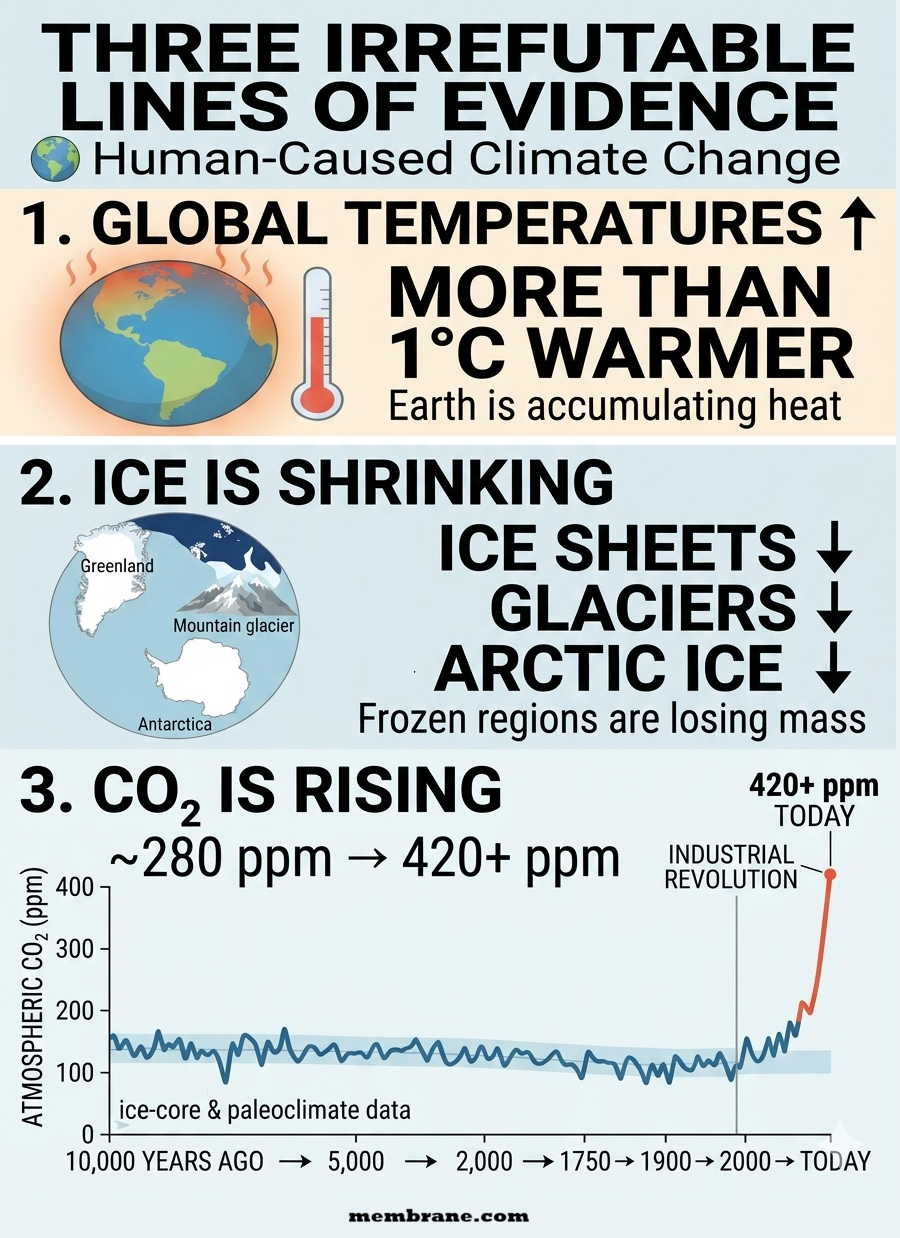
The evidence for human-caused climate change does not rest on a single temperature record, computer model, or scientific study. It comes from multiple independent lines of evidence that converge on the same conclusion.
Three of the clearest are rising global temperatures, shrinking ice sheets and glaciers, and rapidly increasing atmospheric carbon dioxide (CO₂) with a chemical fingerprint linked to fossil fuels.
Each observation is significant on its own. Together, they provide an exceptionally strong scientific case that human activities—especially the burning of coal, oil, and natural gas—are driving the modern warming of Earth’s climate.
1. Rising Global Temperatures
Earth’s average surface temperature has increased by more than 1°C since the late 19th century, with the great majority of that warming occurring since the mid-20th century.
The warming is occurring across the planet and is not limited to the atmosphere. The oceans are absorbing most of the excess heat accumulating in Earth’s climate system, resulting in rising ocean heat content and increasing sea-surface temperatures.
This broad pattern is exactly what scientists expect from an atmosphere increasingly enriched with heat-trapping greenhouse gases.
The evidence also extends beyond simple surface-temperature measurements. Changes in ocean heat, atmospheric temperatures, nighttime temperatures, seasonal patterns, and other components of the climate system independently demonstrate that Earth is undergoing sustained warming.
The planet is not merely experiencing a few unusually hot years. The entire climate system is accumulating heat.
2. Shrinking Ice Sheets, Glaciers, and Arctic Sea Ice
Earth’s frozen regions provide another powerful and highly visible record of climate change.
Greenland and Antarctica are losing ice mass. Glaciers are retreating in nearly every major mountain region, including the Alps, Himalayas, Rockies, Andes, and Alaska. Meanwhile, Arctic sea ice has declined substantially in both extent and thickness.
These changes matter because ice responds directly to changes in the climate system.
When temperatures rise persistently, glaciers retreat and ice sheets lose mass. As snow and ice disappear, darker land and ocean surfaces are exposed, allowing them to absorb more solar energy rather than reflecting it back into space. This creates an important ice-albedo feedback that can amplify warming.
The geographical reach of the changes is particularly important. Ice loss is not occurring at one isolated location. Multiple independent ice systems around the world are responding to a warming planet.
The retreat of glaciers, loss of polar ice, declining Arctic sea ice, and shrinking seasonal snow cover all point in the same direction.
3. Rising Atmospheric CO₂ and the Fossil-Fuel Fingerprint
Perhaps the most direct evidence of human influence comes from the atmosphere itself.
Before industrialization, atmospheric carbon dioxide concentrations were approximately 280 parts per million (ppm). Today, concentrations have risen to more than 420 ppm—an enormous increase occurring over a period far shorter than the natural changes that produced comparable atmospheric concentrations in the distant past.
But the evidence goes beyond simply measuring more CO₂.
Scientists can identify where the additional carbon is coming from.
The carbon added to the atmosphere has an isotopic signature consistent with carbon released from ancient organic material, including coal, oil, and natural gas. Atmospheric oxygen measurements and other observations provide additional evidence that fossil-fuel combustion is responsible for a substantial portion of the increase.
Human activities are therefore not merely occurring at the same time as rising CO₂. We can trace the additional carbon to its source.
And CO₂ has a well-established physical mechanism for affecting climate: it absorbs outgoing infrared radiation, reducing the amount of heat that escapes to space. Increasing its concentration strengthens the atmosphere’s greenhouse effect and produces warming.
Three Independent Signals—One Consistent Explanation
The strength of the evidence comes from the fact that these observations are connected but independently measurable:
Temperatures are rising. Ice is shrinking. CO₂ is increasing—and its chemical fingerprint identifies a major human source.
The observations also extend beyond these three indicators. Rising ocean heat, changing atmospheric circulation, shifting precipitation patterns, increasing ocean acidity, and numerous other changes are consistent with a planet responding to increased greenhouse-gas concentrations.
The critical point is that no single observation has to carry the entire argument.
If global temperatures were rising without increasing greenhouse gases, the explanation would be incomplete.
If atmospheric CO₂ were increasing without a corresponding physical mechanism for warming, the explanation would be incomplete.
If temperatures were rising while glaciers, ice sheets, and Arctic sea ice showed no response, the explanation would be incomplete.
Instead, the evidence converges.
The Climate Fingerprint
The modern climate system displays a coherent pattern:
Human activity increases greenhouse gases → greenhouse gases trap additional heat → Earth’s climate system accumulates energy → global temperatures rise → ice melts and glaciers retreat → oceans warm and expand → additional climate feedbacks amplify the changes.
This is not evidence based on one measurement or one institution. It is a conclusion supported by physics, atmospheric chemistry, temperature records, ocean measurements, satellite observations, glacier surveys, ice-sheet measurements, and paleoclimate evidence.
The overwhelming convergence of these independent observations makes the central conclusion extraordinarily robust:
Earth is warming, the warming is occurring across the climate system, atmospheric greenhouse gases are rising because of human activity, and the resulting enhanced greenhouse effect is driving the modern warming.
The evidence is not merely suggestive.
It is convergent, measurable, physically explainable, and unmistakably human-driven.
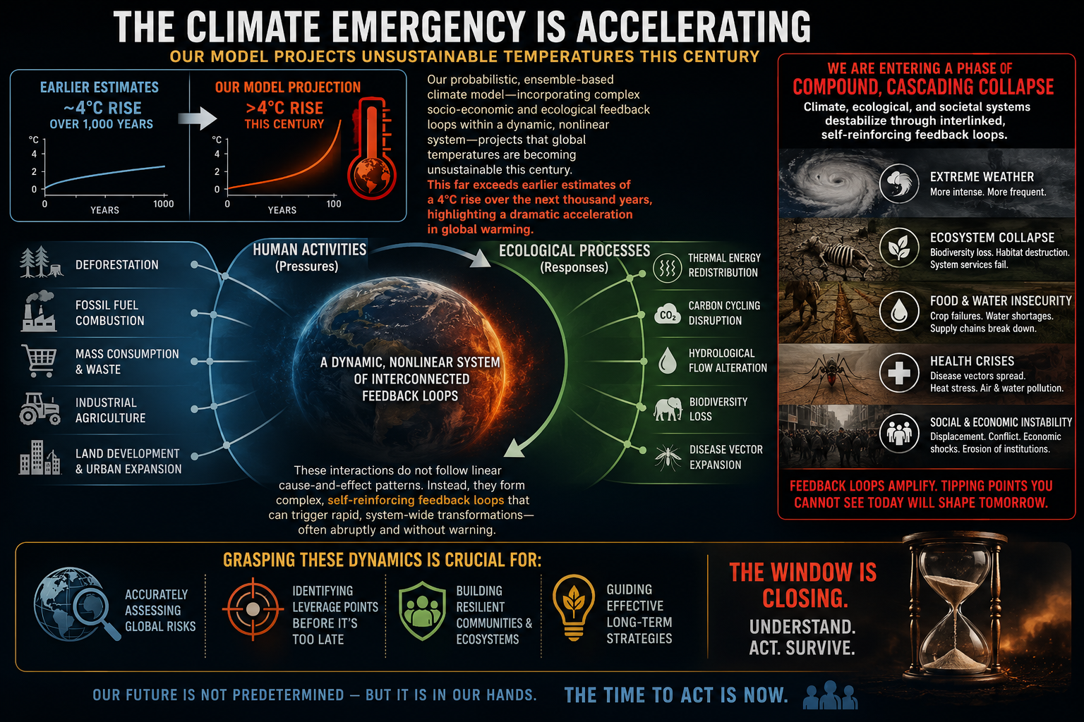
We examine how human activities — such as deforestation, fossil fuel combustion, mass consumption, industrial agriculture, and land development — interact with ecological processes like thermal energy redistribution, carbon cycling, hydrological flow, biodiversity loss, and the spread of disease vectors. These interactions do not follow linear cause-and-effect patterns. Instead, they form complex, self-reinforcing feedback loops that can trigger rapid, system-wide transformations — often abruptly and without warning. Grasping these dynamics is crucial for accurately assessing global risks and developing effective strategies for long-term survival.
Feedback loops amplify climate change and can push interconnected Earth systems past critical tipping points. As tipping points are crossed, they can trigger additional feedback loops and destabilize other climate systems. This cascading “Domino Effect” compresses timescales, accelerates change, and increases the risk of rapid, nonlinear climate transformations.
Bottom line:The question is no longer how warm the planet becomes, but how life on Earth can endure when change outpaces our ability to adapt. We cannot control the laws of physics, but we can control our pollution. The most effective action is to stop burning fossil fuels.
The Rhine River has fallen to historic low levels at several critical measuring stations, disrupting one of Europe’s most important transportation corridors. At Lobith, near the Dutch border, the river dropped to 6.47 meters above NAP, surpassing the previous record set during the severe 2022 drought. River discharge has also plunged to approximately 692 cubic meters per second as prolonged drought and depleted Alpine snowpacks sharply reduce water flowing downstream.
Shipping and Economic Impacts
The Rhine carries hundreds of millions of tons of cargo each year, making low-water events a major economic concern.
Cargo restrictions: Freight vessels are operating at only 20% of normal capacity in some locations to avoid grounding on the riverbed.
Critical bottlenecks: Water levels at the key shipping gauge at Kaub, near Koblenz, have fallen to around 25 centimeters, matching the record lows experienced in 2018.
Rising costs: Reduced shipping capacity has significantly increased transportation costs, disrupted supply chains, and threatens economic growth across Central Europe.
Outlook
Forecasts indicate that river levels could continue falling if hot, dry conditions persist through the coming weeks.
Although authorities report no immediate threat to municipal drinking water supplies, voluntary water conservation measures are being encouraged as drought conditions intensify.
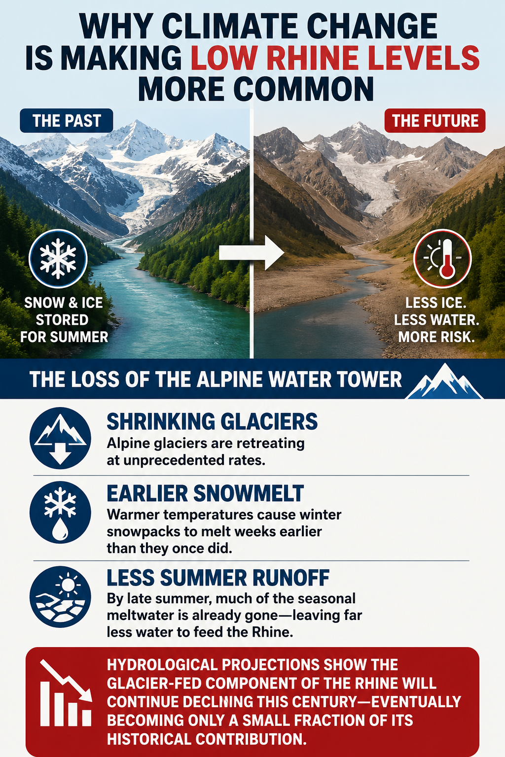
Why Climate Change Is Making Low Rhine Levels More Common
While the Rhine has experienced low-water periods throughout history, climate change is fundamentally altering the river’s hydrology. Research from European hydrological agencies shows that rising temperatures and accelerating glacial retreat are removing the natural systems that historically sustained river flows during dry summers.
The Loss of the Alpine Water Tower
The Alps have long acted as Europe’s natural water reservoir, storing winter snowfall and glacier ice that gradually melted throughout the summer.
That natural buffer is rapidly disappearing.
Shrinking glaciers: Alpine glaciers are retreating at unprecedented rates.
Earlier snowmelt: Warmer temperatures cause winter snowpacks to melt weeks earlier than they once did.
Less summer runoff: By late summer, much of the seasonal meltwater has already been exhausted, leaving far less water to feed the Rhine during periods of peak demand.
Hydrological projections indicate that the glacier-fed component of the Rhine will continue declining throughout this century, eventually becoming only a small fraction of its historical contribution.
A River Increasingly Dependent on Rainfall
As glacier and snowmelt decline, the Rhine is transitioning from a stable, meltwater-supported river into one increasingly dependent on rainfall.
This shift produces much greater variability:
Wetter winters with more intense precipitation.
Longer, hotter summer droughts.
More frequent and severe low-water events.
Increasing disruptions to commercial navigation and regional economies.
Without the stabilizing influence of Alpine snow and glacier melt, prolonged summer droughts now cause the Rhine to reach critical shipping thresholds far more quickly than in the past.
The Rhine’s record-low water levels are more than a short-term drought story—they illustrate how accelerating climate change is transforming Europe’s water resources. As glaciers continue to retreat and heatwaves become more frequent, extreme low-water events are expected to become increasingly common, posing growing risks to transportation, industry, agriculture, and water management across the continent.
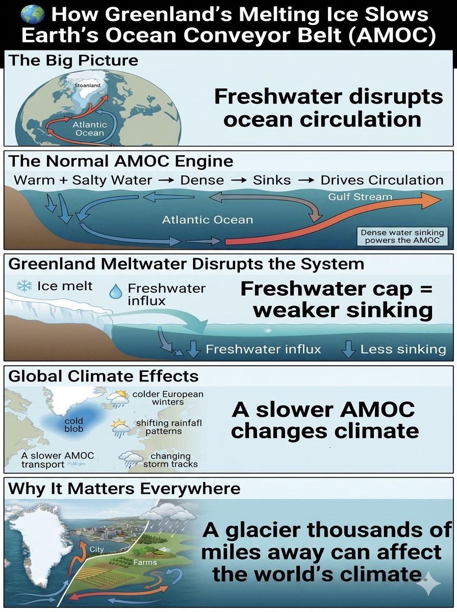
Glacial retreat is weakening the Atlantic Meridional Overturning Circulation (AMOC) by injecting enormous amounts of freshwater into the North Atlantic. This disrupts the natural “ocean conveyor belt” that redistributes heat around the planet and plays a critical role in regulating global climate patterns.
The Mechanics of the Slowdown
The AMOC depends on a delicate balance between temperature and salinity to maintain its circulation. Greenland’s accelerating ice loss is disturbing this balance through a chain reaction:
The Normal Engine: Sinking Water
Under normal conditions, warm, salty tropical water flows northward through the Gulf Stream into the North Atlantic. As this water reaches the subpolar regions near Greenland, it cools. Because cold, salty water is extremely dense, it sinks rapidly into the deep ocean.
This sinking motion acts like the engine of the AMOC, pulling more warm surface water northward while sending colder deep water back toward the tropics. This continuous cycle helps transport heat around the globe.
The Freshwater Cap
The accelerating retreat of the Greenland Ice Sheet is adding vast quantities of freshwater directly into these critical deep-water formation zones.
Unlike salty ocean water, freshwater is less dense. As meltwater accumulates at the surface, it creates a buoyant freshwater layer — sometimes described as a “cap” — that makes it more difficult for surface waters to sink.
Loss of Density: A Slower Conveyor
When surface waters cannot sink efficiently, the downward circulation weakens. The reduced sinking disrupts the entire AMOC system, slowing the transport of heat and altering ocean circulation patterns across the Atlantic basin.
Compounding Regional Feedbacks
The Atlantic “Cold Blob”
One of the most visible signs of AMOC weakening is a persistent region of unusually cold water south of Greenland and near the North Atlantic subpolar gyre, often called the Atlantic Cold Blob.
As the AMOC slows, less tropical heat is transported northward, creating a localized cooling pattern within an otherwise warming planet. This cold region acts as a fingerprint of changing ocean circulation.
Glacial Changes Beyond Greenland
The AMOC is not isolated from the rest of the planet. Research suggests that melting glaciers and ice sheets in other regions can influence global ocean salinity patterns.
Freshwater entering the Pacific Ocean from retreating glaciers and melting icebergs can alter large-scale ocean circulation pathways, potentially affecting the Atlantic system thousands of miles away.
Current Impact and Future Outlook
Observations indicate that the AMOC has weakened compared with conditions in the mid-20th century, although the exact magnitude of the slowdown remains an active area of scientific research because direct measurements of the full system only began recently.
Earlier climate discussions often focused on the possibility of a sudden, abrupt AMOC collapse. More recent high-resolution climate simulations generally suggest that Greenland meltwater is more likely to contribute to a progressive weakening rather than an immediate shutdown.
However, a substantial long-term slowdown would still have major consequences:
🌊 Changes in Atlantic heat transport
❄️ More extreme winter patterns in parts of Europe
🌧️ Shifts in tropical rainfall and monsoon systems
🌪️ Altered storm tracks and regional weather extremes
🌍 Greater disruption of Earth’s climate balance
The AMOC is a reminder that Earth’s climate system is not a collection of isolated parts. A glacier melting thousands of miles away can influence ocean currents, weather patterns, and societies around the world.
The fate of Greenland’s ice is not just an Arctic issue — it is a global climate signal.
The overwhelming interest in Greenland’s dramatic iceberg rollover has raised an important question: Why should people who live thousands of miles from a glacier care?
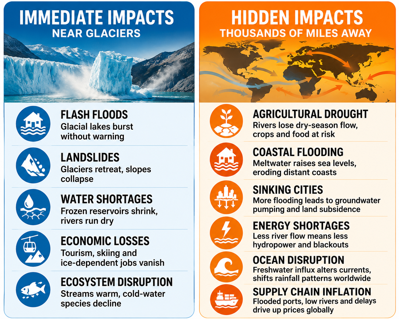
Glacial retreat reshapes nearby landscapes almost immediately, but its most significant impacts extend far beyond the Arctic. As glaciers disappear, the effects ripple through water supplies, food production, energy systems, coastlines, and the global economy.
Immediate Impacts Near Glaciers
Flash floods: Melting ice forms unstable glacial lakes that can burst without warning, devastating downstream communities.
Landslides: As glaciers retreat, they remove the support that stabilizes steep mountain slopes, increasing the risk of massive rockfalls.
Water shortages: Many communities lose the frozen reservoirs that supply rivers during the dry summer months.
Economic losses: Glacier tourism, skiing, and other ice-dependent industries decline as glaciers disappear.
Ecosystem disruption: Cold-water species, including trout and salmon, struggle as streams warm and habitats shrink.
Hidden Impacts Thousands of Miles Away
Agricultural drought: Rivers fed by glaciers lose their dry-season flow, reducing irrigation water for farms far downstream.
Coastal flooding: Meltwater from Greenland and other glaciers raises global sea levels, increasing flooding and shoreline erosion worldwide.
Sinking cities: More frequent coastal flooding often leads to increased groundwater pumping, accelerating land subsidence in vulnerable urban areas.
Energy shortages: Hydroelectric systems that depend on glacier-fed rivers face declining water supplies and reduced power generation.
Disrupted ocean circulation: Large freshwater inputs can alter ocean currents, shifting weather patterns and rainfall across continents.
Higher prices: Lower river levels, flooded ports, and damaged transportation infrastructure disrupt global supply chains, increasing the cost of food, energy, and consumer goods.
Glacial retreat is far more than the loss of scenic ice. It is a global chain reaction that affects freshwater, agriculture, infrastructure, ecosystems, economies, and the stability of the climate system. What begins with melting ice in Greenland ultimately influences the lives of billions of people around the world.
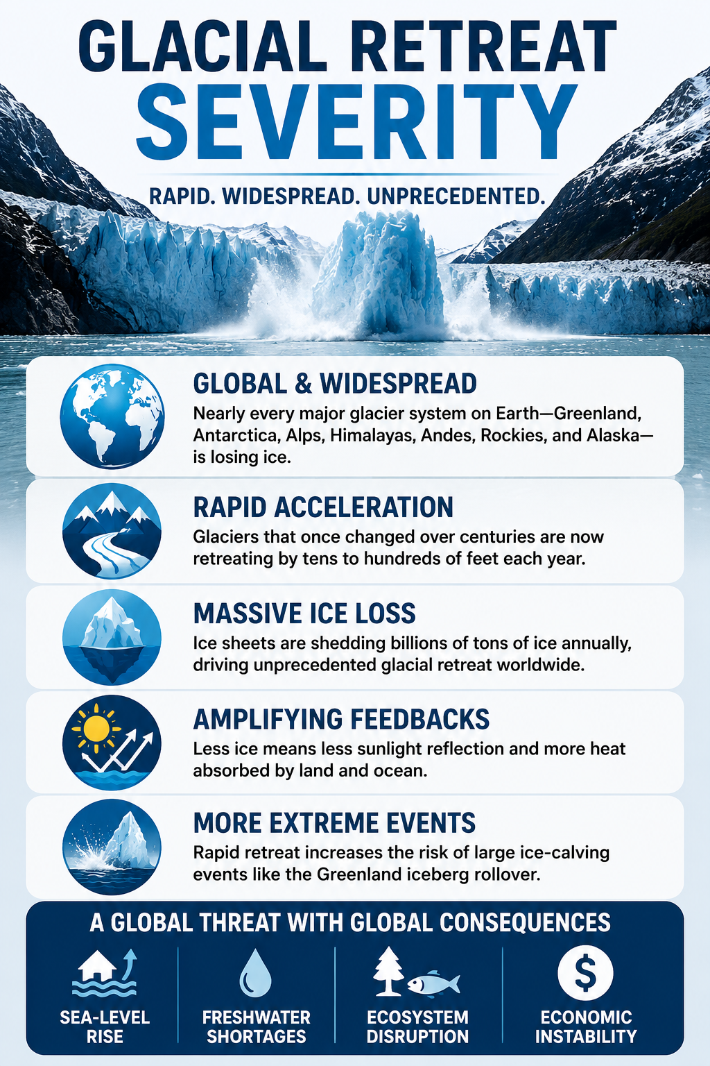
Glacial Retreat Severity
Glacial retreat is accelerating at an unprecedented rate as rising global temperatures drive record levels of melting. Nearly every major glacier system on Earth—from Greenland and Antarctica to the Alps, Himalayas, Andes, Rockies, and Alaska—has experienced sustained ice loss over recent decades. In many regions, glaciers that once changed slowly over centuries are now retreating by tens to hundreds of feet each year, while ice sheets are shedding billions of tons of ice annually. This rapid loss reduces Earth’s ability to reflect sunlight, exposes darker land and ocean surfaces that absorb more heat, and increases the likelihood of large ice-calving events like the recent Greenland iceberg rollover. As these feedback loops intensify, glacial retreat is no longer just a regional environmental issue—it has become a global driver of sea-level rise, freshwater shortages, ecosystem disruption, and economic instability.
On July 25, 2026, a massive iceberg near Ilulissat, Greenland, dramatically rolled over in the ocean, sending a powerful surge of waves and mist toward the coastline. The spectacular event occurred near the UNESCO-listed Ilulissat Icefjord on Greenland’s western coast, where enormous icebergs regularly break away from one of the most active glacier systems on Earth.
As the giant block of ice rotated with tremendous force, it revealed a jagged, ancient underside that had been hidden beneath the ocean surface. Fortunately, no injuries or property damage were reported from the resulting waves.
Why Do Giant Icebergs Flip?
Icebergs are naturally unstable structures. They float with roughly 90% of their mass hidden below the waterline, and their shape changes continuously as they melt.
1. Uneven Melting Shifts the Center of Gravity
Icebergs often become unstable because melting does not occur evenly. Warmer ocean water can erode the submerged portion of the iceberg, while sunlight and warmer air melt the upper surface.
As the underwater shape changes, the iceberg’s center of gravity shifts. Eventually, the enormous ice mass becomes unstable and violently rotates until it reaches a new equilibrium.
2. The Ilulissat Region Is an Iceberg Hotspot
The event occurred near the terminus of Sermeq Kujalleq Glacier, one of the fastest-moving glaciers in the world.
This glacier feeds the Ilulissat Icefjord and has historically produced some of Greenland’s largest icebergs. Its rapid flow and frequent calving make the region one of the most dramatic locations on Earth to witness glacier change.
Why This Matters for Climate Change
Iceberg flips are a natural part of the iceberg life cycle, but climate change is altering the conditions that create and accelerate these events.
A Warmer Arctic Means Faster Ice Loss
The Arctic is warming much faster than the global average, causing:
Faster glacier flow: Warmer temperatures increase ice loss and can accelerate glacier movement toward the ocean.
More frequent calving: As glaciers lose mass, more large icebergs break away.
More rapid underwater melting: Warmer ocean waters attack the submerged portions of icebergs, destabilizing them more quickly.
Greater instability of ice structures: Rapid melting creates unusual shapes that are more likely to roll over.
Greenland’s ice sheet is now losing hundreds of billions of tons of ice each year, contributing to rising global sea levels. The surrounding Arctic Ocean is also warming rapidly, intensifying the processes that reshape Greenland’s glaciers and icebergs.
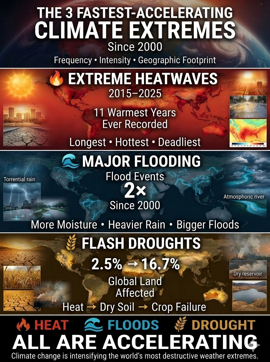
Since 2000, three climate extremes have accelerated faster than all others in their frequency, intensity, and geographic reach: extreme heatwaves, major flooding, and heat-triggered flash droughts.
1. Extreme Heatwaves The Trend: The years 2015–2025 were the 11 warmest years ever recorded globally. The Impact: Heatwaves have become dramatically longer, hotter, and more widespread, producing record-breaking temperatures on every continent. They now account for the largest share of climate-related deaths worldwide and increasingly strain power grids, agriculture, water supplies, and public health systems.
2. Major Flooding & Extreme Rainfall The Trend: According to United Nations disaster records, major flood events have more than doubled since 2000, increasing from approximately 1,389 events to more than 3,254. The Impact: As the atmosphere warms, it holds significantly more water vapor, intensifying the global water cycle. The result is a sharp rise in short-duration, high-intensity rainfall that overwhelms drainage systems, dams, rivers, and urban infrastructure.
3. Heat-Triggered Flash Droughts The Trend: The share of global land affected by heat-driven drought has expanded from 2.5% in the 1980s to 16.7% in recent years, with the rate of increase accelerating roughly eightfold since 2000. The Impact: Unlike traditional droughts that develop over months, flash droughts can emerge within weeks. Extreme heat rapidly strips moisture from soils and vegetation, triggering sudden crop failures, water shortages, wildfire risk, and severe agricultural losses before communities have time to respond.
Bottom Line: These three extremes—extreme heat, extreme flooding, and flash droughts—are no longer isolated events. They are accelerating simultaneously, amplifying one another, and reshaping climate risk across the globe. Together, they represent the clearest evidence that climate change is driving a new era of increasingly frequent, intense, and widespread extreme weather.