bookmark_borderGreenland Atmospheric Rivers

by Sidd Mukherjee

Historically in the United States, atmospheric rivers (AR) have been associated with the West Coast. Now, AR activity is getting more attention on the East Coast.

Atmospheric rivers have been putting serious rainfall melt on Greenland for the last decade, too.

Darker snow surfaces absorb more sunlight and melt quicker. This effect is visible in Greenland. Box et al.,”Greenland ice sheet albedo feedback: thermodynamics and atmospheric drivers,” The Cryosphere, v6, pp821 et seq., doi:10.5194/tc-6-821-2012 state: ” Thus, intraseasonal summer albedo variability exceeds 0.50 over parts of the ice sheet where a snow layer ablates by mid-summer, exposing an impurity-rich ice surface …” Prof. Box is now investigating soot from North American wildfires as a factor in the darkening of Greenland.
— from News from the Ice Wars:An Occasional Bulletin

“Furthermore, our investigation of the short- and long-term relationships between moisture transport vents and modeled GrIS surface properties proves that this correspondence between the years of enhanced AR activity and anomalous GrIS mass loss is not a coincidence. Strong AR impacts cause increased melt in all areas of the GrIS and decreased SMB in the ablation zone during summer, and warm seasons with above-average GrIS melt extent are characterized by anomalously strong moisture transport by ARs over Greenland. ARs typically result in SMB gains in the GrIS ablation zone during nonsummer seasons and in the accumulation zone during all seasons. However, the intense summer SMB losses in the ablation zone during years of enhanced moisture transport outweigh the positive AR contributions to SMB in other regions and seasons. The scaling of melt versus snowfall in Figures 9 and 11 shows that the magnitude of mass loss from summer melt in the ablation zone has a much greater upper limit than mass gain from snowfall.”

In this paper see especially Fig. 9.

Then in 2018, Neff publishes again: more on atmospheric rivers causing the full surface melt in greenland in 2012.
— from Atmospheric River Impacts on Greenland Ice Sheet SurfaceMass Balance

“Rainfall at the Greenland ice sheet Summit 14 August 2021, was delivered by an atmospheric river (AR). Extreme surface ablation expanded the all-Greenland bare ice area to near-record-high with snowline climbing up to 788 ± 90 m. Ice sheet wet snow extent reached 46%, a record high for the 15–31 August AMSR data since 2003. Heat-driven firn deflation averaged 0.14 ± 0.05 m at four accumulation area automatic weather stations (AWSs). Energy budget calculations from AWS data indicate that surface heating from rainfall is much smaller than from either the sensible, latent, net-longwave or solar energy fluxes. ”

“Rainfall heat transfer contributed just 2% to the calculated melting at a 2,200 m elevation western ice sheet site (CP1 a.k.a. Crawford Point). Condensation or sensible heat transfer from the warm air mass was a far more powerful heat source. The observed amount of melting delivered by the AR could have happened without rain- fall. Yet, the impacts of rain and meltwater refreeze are considerable provided that percolation delivers the melt below where the heat can be radiated away and that refreeze-at-depth occurs. We found no evidence for the latter condition because the rainfall amount was not extreme and the surface was already melting hours before the rain- fall. Understanding any changes to the frequency and intensity of ARs appears to be a more important research target than the heat content of the liquid precipitation ARs may or may not produce Further, while rainfall that does not percolate and refreeze may not have strong surface thermodynamic impacts, rainfall contribution to the hydraulics of Greenland ice (Doyle et al., 2015) may be more consequential to ablation through ice sheet flow acceleration.”

open access, read all about it. The Watson river discharge described in the paper drains the saddle between north and south domes and is an area that i watch closely for signs of collapse. I suppose this is one.
— from Greenland Ice Sheet Rainfall, Heat and Albedo Feedback Impacts From the Mid-August 2021 Atmospheric River

ALSO SEE:
West Coast Atmospheric Rivers Brouse (2023)

East Coast Atmospheric Rivers Brouse (2023)

The Reign of Violent Rain Brouse and Mukherjee (2023)

The Age of Loss and Damage Brouse (2023)

Climate Change Impacts on Flood Risks and Real Estate Values Sidd Mukherjee and Daniel Brouse (2023)
bookmark_borderWest Coast Atmospheric Rivers

by Daniel Brouse

As the Earth warms, the air will hold more moisture. More moisture-laden air moves over land and creates atmospheric rivers (Pineapple Express). The Journal EOS in the article Atmospheric Rivers Spur High-Tide Floods on U.S. West Coast said, “Atmospheric rivers are narrow bands of moisture that travel across the lower troposphere, generally at the leading edges of massive low-pressure systems. At their peak, they can carry as much water through the sky as the Amazon River does on land. They unleash intense winds and heavy rain as they surge across the Pacific Ocean, eventually making landfall on the U.S. West Coast, contributing to many high-tide flooding events.”

The atmospheric rivers also bring heavy rainfall inland causing extreme flooding. In October of 2021 NOAA said, “a convergence of storms brought more than half a foot of rain to parts of the Bay area in addition to strong winds, flash floods, and mud/landslides. They also bring the potential for heavy snow to higher elevations in the Sierra Nevada mountain range.” (Atmospheric River Hits the West Coast)

In December 2022 and January 2023, California experienced nine back-to-back atmospheric rivers; the longest stretch of continuous atmospheric river conditions on record. NOAA went on to report, “Several atmospheric rivers struck in March 2023, bringing heavy rain and snowfall to much of the West. According to the California Department of Water Resources, the statewide snowpack was among the deepest ever recorded for the end of March — 237% of normal.”

In October of 2023, a tropical storm turned into category 5 Hurricane Otis in a record 12-hour intensification. Hurricane expert Kerry Emanual said Otis was supercharged by global warming. Historically, hurricanes’ intensification was driven by ocean surface temperatures. Otis was additionally supercharged by increasing temperatures deeper in the ocean. Hurricane Otis became the strongest on record to hit Mexico’s Pacific coast. NOAA reported, “When Otis first hit, mudslides outside the city in mountainous terrain prevented crews from traveling to the city to provide aid, and according to the Associated Press, the 10,000 troops that were deployed to the area lacked the tools needed to clear mud and downed trees off roads.”

ALSO SEE:
East Coast Atmospheric Rivers Brouse (2023)

The Reign of Violent Rain Brouse and Mukherjee (2023)

The Age of Loss and Damage Brouse (2023)

Climate Change Impacts on Flood Risks and Real Estate Values Sidd Mukherjee and Daniel Brouse (2023)


bookmark_borderEast Coast Atmospheric Rivers

by Daniel Brouse
December 10, 2023

As the Earth warms, the air will hold more moisture (water vapor). When more moisture-laden air moves over land it can create atmospheric rivers. In the Northwestern USA, the atmospheric rivers are commonly called the Pineapple Express. The Journal EOS in the article Atmospheric Rivers Spur High-Tide Floods on U.S. West Coast said, “Atmospheric rivers are narrow bands of moisture that travel across the lower troposphere, generally at the leading edges of massive low-pressure systems. At their peak, they can carry as much water through the sky as the Amazon River does on land. They unleash intense winds and heavy rain as they surge across the Pacific Ocean, eventually making landfall on the U.S. West Coast, contributing to many high-tide flooding events.”

Historically in the United States, atmospheric rivers (AR) have been associated with the West Coast. Now, AR activity is getting more attention on the East Coast. “Actually their frequency is not really increasing. Meteorologists have used the term for decades. It has simply become popular by the media. Just like polar vortex,” said Jeff Boyne National Weather Service meteorologist and climatologist. Indeed, “atmospheric rivers are more frequent on the East Coast than they are on the West Coast,” said Jason Cordeira, associate professor of meteorology at Plymouth State University. “They’re just not as impactful and don’t usually produce as much rainfall.”

What is changing is the research into the types and increasing intensity of East Coast AR events. “Between 1958 and 2012, the Northeast saw more than a 70% increase in the amount of rainfall measured during heavy precipitation events, more than in any other region in the United States. Projections indicate continuing increases in precipitation, especially in winter and spring and in northern parts of the region,” as reported in The US Fourth National Climate Assessment.

Most types of East Coast ARs are increasing in intensity likely due to climate change. The study Identifying Eastern US Atmospheric River Types and Evaluating Historical Trends reports, “The impact of increasing moisture transport could be significant across the northeast corridor from Washington D.C. to Coastal Maine, as it increases the risk of extreme precipitation from landfalling ARs. The results indicate most ARs in the study domain are forced by extratropical cyclones, with lee side low pressure systems and coastal lows along the Atlantic Coast (e.g. nor’easters) responsible for producing the strongest ARs.”

How Fast Are Atmospheric Rivers Gaining Intensity?
Some areas of the world are now warming so fast, it is becoming more difficult to measure the change from “normal” or average. Jeff Boyne of the NWS said, “There are climate normals that are updated every 10 to 15 years, because the planet is warming so fast. The ENSO (El Nino-Southern Oscillation) regions are warming so fast that those normals are being updated every 5 years.” Overall, how fast is climate change accelerating? Rapidly. “It’s so far outside anything we’ve seen, it’s almost mind-blowing,” says Walter Meier, who monitors sea-ice with the National Snow and Ice Data Center. “September was, in my professional opinion as a climate scientist, absolutely gobsmackingly bananas,” said Zeke Hausfather, at the Berkeley Earth climate data project.”

ALSO SEE:

The Reign of Violent Rain Brouse and Mukherjee (2023)

The Age of Loss and Damage Brouse (2023)

Climate Change Impacts on Flood Risks and Real Estate Values Sidd Mukherjee and Daniel Brouse (2023)

bookmark_borderSea Level Rise and Saturation

By Daniel Brouse
October 28, 2023

What causes sea level rise? If the melting ice and snow isn’t going into the sea, where is it going?

NOAA says:
The volume of the ocean is expanding as the water warms. Thermal expansion happens when water gets warmer, which causes the volume of the water to increase. About half of the measured global sea level rise on Earth is from warming waters and thermal expansion.

There is a shift of liquid water from land to ocean due largely to humans depleting ground water.

United Nations DRR says:
For every degree Celsius in warming, the water-holding capacity of the atmosphere increases by about 7%. Record-high sea temperatures ensure there is more moisture (in the form of water vapour) in the atmosphere, by an estimated 5-15% compared to before the 1970s, when global temperature rise began in earnest.

Water vapour is a powerful greenhouse gas. Since the 1970s, its rise likely increased global heating by an amount comparable to that from rising carbon dioxide. We are now seeing the consequences. In the current climate, for average all-sky conditions, water vapour is estimated to account for 50% of the total greenhouse effect, carbon dioxide 19%, ozone 4% and other gases 3%. Clouds make up about a quarter of the greenhouse effect.

The main greenhouse gases – carbon dioxide, methane, nitrous oxide and ozone – don’t condense and precipitate. Water vapour does, which means its lifetime in the atmosphere is much shorter, by orders of magnitude, compared to other greenhouse gases. On average, water vapour only lasts nine days,

The most common measure of water vapour in the atmosphere is relative humidity. Deadly humid heat affects billions including the US Midwest this century. “It’s very disturbing,” study co-author Matthew Huber of Purdue University. “It’s going to send a lot of people to emergency medical care.”

The study Greatly enhanced risk to humans as a consequence of empirically determined lower moist heat stress tolerance was conducted by Purdue and George Mason University and published August 15, 2023.

These results indicate that a significant portion of the world’s population will experience — for the first time in human history — prolonged exposures to uncompensable extreme moist heat. Humans will struggle to adapt to these conditions in a warmer world as they will present widespread challenges across many aspects of food-energy-water security, human health, and economic development including in the world’s most populous and most vulnerable regions.

At 3C (5.4F) of yearly average warming, more than 1.5 billion people will suffer. In the summer of 2023,
the Earth experienced about a month of warming at 3C above pre-industrial levels. Both 2022 and 2023 saw a record number of heat related deaths. More than 61,000 Europeans died from extreme heat in the summer of 2022.

Sea Level Rise in the Sky
So how much of the melting ice is going into the sky instead of just dripping into the sea?

NASA says:
Hot air expands, and rises; cooled air contracts – gets denser – and sinks; and the ability of the air to hold water depends on its temperature. A given volume of air at 20°C (68°F) can hold twice the amount of water vapor than at 10°C (50°F). The relationship of how much water a given mass of air actually holds compared to the amount it can hold is its relative humidity.

When air holds as much water vapor as it can for a given temperature (100% relative humidity), it is said to be saturated. If saturated air is warmed, it can hold more water (relative humidity drops), which is why warm air is used to dry objects–it absorbs moisture. On the other hand, cooling saturated air (said to be at its dew point) forces water out (condensation). This is why a container of a cold beverage sweats: it cools the air next to it and moisture from the air condenses on the outside of the can.

Air warmed by ocean currents picks up a lot of moisture. As the heated air rises, it expands, which is measured at the surface as low air pressure. Expanding air cools, which forces it to lose its moisture as rain or snow. The opposite is true for sinking air. Such air compresses and warms. In a zone of high pressure like this, moisture is absorbed by the air from its surroundings.

According to the USGS, the volume of all water on Earth is estimated to be 332.5 million cubic miles. As a result of the hydrologic cycle, Earth’s water is never in one place for too long. It evaporates, turns to vapor, condenses to create clouds and falls back to the surface as precipitation. The cycle then begins again.

“On average, there is about the equivalent of 30 mm [1.2 inches] of rain in the form of vapor available to fall over any point of Earth’s surface,” Frédéric Fabry, the director of the J. Stewart Marshall Radar Observatory and an associate professor of the environment and the Department of Atmospheric and Oceanic Sciences at McGill University in Canada said. “That’s around 55 pounds [25 kilograms] of water over every square yard, most of which is in the form of vapor,” he said. Given that the surface area of Earth is about 197 million square miles (510 million square kilometers), there’s around 37.5 million-billion gallons of water in the atmosphere, Fabry said. If all of this mass were to fall at once, it would raise the global ocean level by about 1.5 inches (3.8 centimeters), he added.

Climate Change Post reports, “Just a few cm of sea-level rise may double the frequency of coastal flooding.”

A study published in the journal Scientific Reports, if sea levels rise between 2 and 4 inches (5 and 10 cm), it will double the flooding frequency in a host of regions, “particularly in the tropics.”

It looks like the atmosphere currently holds about 1.5 inches of sea level rise…
as the temperature rises will it be able to hold 3 inches?

What happens when the atmosphere can’t hold any more?

The Reign of Violent Rain

Climate Change: Rate of Acceleration

Climate Change: How Long Is “Ever”?

The Human Induced Climate Change Experiment

bookmark_borderAntarctic Ice Shelves Shrink at Alarming Rate

“Scientists track ‘alarming’ melt in Antarctic ice shelves”
“Forty percent of Antarctica’s ice shelves are shrinking, worrying scientists”

“We expected most ice shelves to go through cycles of rapid, but short-lived shrinking, then to regrow slowly. Instead, we see that almost half of them are shrinking with no sign of recovery,” said lead author Benjamin Davison, research fellow at the University of Leeds.

“Acceleration of glaciers due to ice shelf deterioration has added about six millimetres to global sea level since the start of the study period,” said Davison. “The ocean absorbs a lot of atmospheric heat and carbon and the Southern Ocean surrounding Antarctica is the largest contributor to that, so it’s a hugely important regulator of global climate.”

“We are seeing a steady attrition due to melting and calving… This is further evidence that Antarctica is changing because the climate is warming,” Anna Hogg, a University of Leeds professor who co-authored the study, said.

The study Annual mass budget of Antarctic ice shelves from 1997 to 2021 concludes:
We show that Antarctic ice shelves have exported 67,000 ± 3200 Gt of freshwater to the Southern Ocean from 1997 to 2021, of which solid ice (calving) provided 60% and which has been fairly constant on annual timescales since 1997 other than spikes in solid ice export from large calving events. These spatially and temporally resolved freshwater flux estimates could be used to inform modeling investigations seeking to constrain any emerging impacts of Antarctic freshwater export on Southern Ocean circulation, iogeochemical cycling, and ecological productivity, compared to other observationally constrained climate forcings, such as changes in sea ice extent and formation rates.

Building on previous studies (7, 45), we show that many Antarctic ice shelves deteriorated significantly from 1997 to 2021 and that the vast majority of those have significant mass loss trends. Pan-Antarctic ice shelf mass decreased overall by 7500 ± 1500 Gt during the 1997–2021 period due to both terminus retreat (6200 ± 700 Gt) and basal melt–induced thinning (4480 ± 1420 Gt), which were partially offset by increases in grounding line discharge (1770 ± 870 Gt), SMB (340 ± 90 Gt), and grounding line retreat (1070 ± 170 Gt). Ice shelf mass loss was regionally concentrated along the Antarctic Peninsula, the Amundsen Sea, and Bellingshausen Sea coastlines in West Antarctica, and in Wilkes Land and Victoria Land in East Antarctica. Pan-Antarctic ice shelf mass has increased since 2002 due to the steady advance of a small number of large ice shelves, but this growth masks significant and sustained reductions in the mass of many Antarctic ice shelves. Basal melt–induced thinning was the dominant mass loss term for a slight majority (52 to 73%) of ice shelves that lost mass. Both basal melt–induced thinning and retreat were significantly positively correlated with grounding line discharge change at many ice shelves, but there was a wide range in the strength and form of the relationship between ice shelves. These new observations provide a more detailed picture of the health of Antarctic ice shelves and drivers of ice shelf mass change than was previously available and highlight the wide-ranging relationships between ice shelf mass change and grounding line discharge change.

Also see:

Climate Change: Rate of Acceleration Brouse and Mukherjee (2023)

Sea-level Rise Mukherjee and Brouse (2022 and 2023)

Climate Change: How Long Is “Ever”? Brouse (2023)

bookmark_border10% of Swiss Glaciers Melt

* As thawing accelerates, Swiss glaciers lost 10% of their volume in the past 2 years
* One glacier had to stop being measured because it disappeared
* The thaw is irreversible
* Much of Europe’s drinking water comes from the glaciers

“The acceleration is dramatic, with as much ice being lost in only two years as was the case between 1960 and 1990. The two extreme consecutive years have led to glacier tongues collapsing and the disappearance of many smaller glaciers,” the Swiss Academy of Sciences said.

The AP reported:
Swiss meteorologists reported in August that the zero-degree Celsius level — the altitude where water freezes — had risen to its highest level ever recorded, at nearly 5,300 meters (17,400 feet), which means that all the Swiss Alpine peaks faced temperatures above freezing.

Matthias Huss, head of the GLAMOS glacier monitoring center, said, “Glaciers are the ambassadors of climate change. They make it very clear what is happening out there because they respond in a very sensitive way to warming temperatures. The study underlines once again that there is big urgency to act now if you want to stabilize (the) climate, and if you want to save at least some of the glaciers.”

“And once we have destabilized ice sheets, there will be no stable coastline for centuries. I repeat: There will be no stable coastline for centuries. I apologize to the children,” said Sidd Mukherjee in the paper Longthaw.

Also see:

Climate Change: Rate of Acceleration Brouse and Mukherjee (2023)

Sea-level Rise Mukherjee and Brouse (2022 and 2023)

Climate Change: How Long Is “Ever”? Brouse (2023)

bookmark_borderCalifornia Homeowners Insurance Consider Climate Change Prices

California use to only allow a max of 7% increase a year on homeowners insurance… and only base premiums on past payouts on a property. Not anymore.

“California will let insurance companies consider climate change when setting their prices, the state’s chief regulator announced Thursday, a move aimed at preventing insurers from fleeing the state over fears of massive losses from wildfires and other natural disasters. The rule change could mean higher rates for homeowners who are already seeing dramatic increases. Eight insurance companies doing business in California have requested rate increases of at least 20% or higher this year, according to the California Department of Insurance,” AP news reported.

“Modernizing our insurance market is not going to be easy or happen overnight. We are in really unchartered territory and we must make difficult choices when the world is changing rapidly.” California Insurance Commissioner Ricardo Lara said.

“Insurers have advanced a very powerful argument that the past is not as good a predictor of the future as it used to be,” said Amy Bach, executive director of United Policyholders. “I think the (Insurance) department did what it needed to do to try to restore a viable market. We don’t have a viable market right now in this state in a lot of areas.”

Florida and Louisiana already have a homeowners insurance crisis with companies fleeing the states. The 9th National Risk Assessment for Homeowners Insurance found 1/4 of all homes in the nation are underpriced for climate risk insurance.

More articles on Flood Insurance, Rising Sea Levels and Global Warming.

bookmark_borderClimate Change: Insurance Risk

The 9th National Risk Assessment for Homeowners Insurance found climate risks place 39 million U.S. homes at risk of losing their insurance. “Sound pricing is going to make it unaffordable to live in certain places as climate impacts emerge.”

“There’s this climate insurance bubble out there,” said Jeremy Porter, the head of climate implications at First Street and a contributor to the report. “And you can quantify it.”

“There’s no education to the public of what’s going on and where the risk is,” said Porter, explaining that most insurance models are proprietary. Even the Federal Emergency Management Agency (FEMA) doesn’t make flood insurance pricing available to the public. Homeowners must obtain coverage through a private insurance broker for a quote.

Wildfires are the fastest growing natural disaster risk. According to the report, “It’s not just wildfires – pressure on flood and wind insurance is increasing, too.”

Porter went on to say, “You don’t want someone to live in a place that always burns. They don”t belong there. We’re subsidizing people to live in harm’s way. Large numbers of people will need to be relocated away from areas that will be uninsurable. There is a reckoning on the horizon and it’s not pretty.”

Flow Speeds

The burning of fossil fuels and other human released emissions have impacted momentum’s impact. A warmer atmosphere can hold more moisture. Warmer air allows for the creation of more massive raindrops. Warmer ocean temperatures create stronger hurricanes. Hail and tornadoes form in strong thunderstorm clouds with intense updrafts, high liquid-water content, and large water droplets.

Sidd added: It’s worse than that. Wind and water flow forces scale as the square of velocity, so as flow speeds increase (say due to more intense heating or heavier rain) the damage scales as the square of the velocity.

So a twenty mile an hour wind exerts four times as much force as a ten mile an hour wind. And a forty mile an hour wind exerts sixteen times as much force as a ten mile an hour wind. A wind of fifty miles an hour exerts twenty five times and a wind of sixty miles an hour exerts thirty six times as much force as one of ten miles an hour. Then you have the density term. Water is about eight hundred times denser than air, So the force exerted by a ten mile an hour flow of water is eight hundred times that of a ten mile an hour wind. So as flow velocities go up due to climate change, force and damage scale as square of the velocities. What is not clear is how much these velocities increase with climate change. But in a sense we are seeing this already as, for example, flood and sewage systems succumb and hillsides fall down, and so on.

Climate change’s influence on wind and water flow forces caused more severe damage and deaths. The Maui wildfire of August 2023 is an example. What would have been a fairly routine wildfire was fanned out-of-control by hurricane force winds. One headline read, “Maui fires: Hawaii blazes fanned by Hurricane Dora”. Another headline read, “Hawaii wildfires kill as ‘apocalypse’ hits Maui island”. The New York Times reported, “Gov. Josh Green of Hawaii said on Thursday that the devastating wildfires that swept through western Maui and killed at least 55 people, and possibly many more, were ‘likely the largest natural disaster in Hawaii state history.'”

Both wind and water flow forces contributed to the devastation. Hurricane Dora was at least 500 miles from Hawaii yet the wind forces impacted the fire in Maui. The winds were so strong that before the fire reached Lahaina extremely hot air blew over the town. The streets were so hot they burnt people’s feet trying to flee. The surface of everything became hot. Even after people jumped into the ocean, they said the debris in the water was too hot to float on. Almost all the boats in the harbor burned.

The blast of hot air over Lahaina created the conditions for a flashpoint. A flashpoint is the temperature at which a particular organic compound gives off sufficient vapor to ignite in air. The entire town ignited so quickly that warning sirens could not be activated and people did not have time to escape.

In an unexpected twist, water flow forces also contributed to the chaos. How could water flow add to the fire emergency conditions? When people fled the heat and fire, they jumped into the sea. ABC news reported: Shawn Dougherty, of Lahaina, was among the hundreds of residents forced to flee the resort city when the wildfire began engulfing their homes.

Like others, Dougherty said his only means of survival was to jump into the ocean with his girlfriend, but while some found safety in nearby jetties, the rocks and coral tore up Dougherty’s body.

“At one point, it seemed like I might drown,” he told ABC News. “{I’m a good swimmer, but the water was just really rough because of the wind and the turbulence.”

Norway Floods 2023

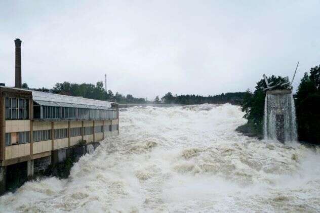
Also in August of 2023, climate change’s influence on water flow forces caused more severe damage and deaths. AccuWeather reported, “Dam bursts open as deadly flooding washes away homes in Norway. Torrents of water gushed through multiple towns across Norway and landslides cascaded down mountainsides after a deluge drenched Norway.”

Summary

By increasing the energy in the system, humans have increased flow volumes, masses and velocities leading to increased damage (and deaths.)

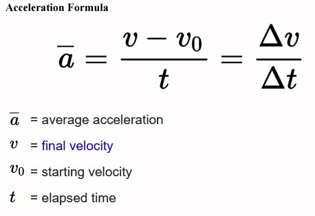
Newton’s second law: F = m * a
F = force
m = mass of an object
a = acceleration

Acceleration Formula

ALSO SEE
Climate Change: Rate of Acceleration
By 2020, there was enough data to see the “doubling period” of some anthropogenic climate affects had gone from 100 years to 10 years. For instance the rate of sea level rise has gone from about 1.5 millimeters per year to over 3 millimeters. We expect to see the doubling period to continue to shrink raising the possibility of sea levels rising a foot/year by 2050.

Tipping points and feedback loops are parts of an equation that determine the rate of acceleration in climate change.

Climate Change: The End of Times

More articles on Flood Insurance, Rising Sea Levels and Global Warming.

bookmark_borderInsurance, and the Lack Thereof

The Washington Post reported, “Home insurers cut natural disasters from policies as climate risks grow“.

“Allstate, American Family, Nationwide, Erie Insurance Group and Berkshire Hathaway — have told regulators that extreme weather patterns caused by climate change have led them to stop writing coverages in some regions, exclude protections from various weather events and raise monthly premiums and deductibles.”

“they will cut out damage caused by hurricanes, wind and hail from policies underwriting property along coastlines and in wildfire country”

“places once considered safe from natural catastrophes could lose crucial insurance protections while their natural disaster exposure expands or intensifies ”

“Allstate said its climate risk mitigation strategy would include “limiting new [auto and property] business … in areas most exposed to hurricanes” and “implementing tropical cyclone and/or wind/hail deductibles or exclusions where appropriate.””

“Nationwide said it no longer underwrites coverage for “properties within a certain distance to the coastline” because of hurricane potential.”

“There’s no place to hide from these severe natural disasters”

“a policy in a region afflicted by hurricanes may exclude coverage for wind or hail damage, or in wildfire country, a policy without fire and smoke protection.”

“Activity has been observed in recent years that has differed from historical norms or modeled expectations.”

More articles on Flood Insurance, Rising Sea Levels and Global Warming.

bookmark_borderClimate Change: Stranded on an Island

by Daniel Brouse

Climate change brings with it the inevitability of rising sea levels. Even if green house gas emissions were stopped completely, the sea will continue to rise for hundreds or thousands of years.

Not only will the submerged properties be affected by the rising tides, so will all the new island properties. Initially, some properties will just be temporarily cut-off from civilization. Eventually, those temporary islands will become permanent.

An initial reaction may be “Oh, I’ve always wanted to live on island;” however, being stranded on a deserted island is not fun. It is important to look forward and evaluate the risk in value to real estate. Much of the newly isolated land will become worthless.

ARS Technica reports, “having a property above water won’t be much good if flooding nearby means you can’t get to a hospital or grocery store when you need to or lose access to electricity or other services. It’s entirely possible for rising seas to leave a property high, dry, but uninhabitable as rising seas cut connections to essential services. A group of researchers has analyzed the risk of isolation driven by sea level rise, and shows it’s a major contributor to the future risks the US faces.”

If you’re interested in comparing the risk of isolation to that of inundation, the researchers built a website that lets you explore the risks under different sea level rise scenarios.

The Journal Nature published “Risk of isolation increases the expected burden from sea-level rise”:

The typical displacement metric for sea-level rise adaptation planning is property inundation. However, this metric may underestimate risk as it does not fully capture the wider cascading or indirect effects of sea-level rise. To address this, we propose complementing it by considering the risk of population isolation: those who may be cut off from essential services. We investigate the importance of this metric by comparing the number of people at risk from inundation to the number of people at risk from isolation. Considering inundated roadways during mean higher high water tides in the coastal United States shows, although highly spatially variable, that the increase across the United States varies between 30% and 90% and is several times higher in some states. We find that risk of isolation may occur decades sooner than risk of inundation. Both risk metrics provide critical information for evaluating adaptation options and giving priority to support for at-risk communities.

More articles on Flood Insurance, Rising Sea Levels and Global Warming.