bookmark_borderHow much land do I need for my own shit?

Tonight’s homework assignment: How much land do I need for my own shit? (AKA The Eat n’ Poop Experiment)

Both literally and figuratively.

This is an experiment I’ve been working on for years. And when you actually try to do it—when you have to think about where your food comes from, where your water comes from, and what happens to everything that comes out of you—you gain a very different perspective.

And yes, sometimes the experiment even comes down to a question like: Do I eat the worm, or don’t I?

Food and water are big problems.

But getting rid of what comes out of you can be an even bigger problem.

I’ve been meeting quite a few other people who are “doing it”—trying to become more self-sufficient, reduce their dependence on centralized systems, and figure out what is actually required to sustain a human being.

So I thought a good test for me would be to reevaluate the whole concept at two scales:

Macro. And micro.

Tonight is micro night.

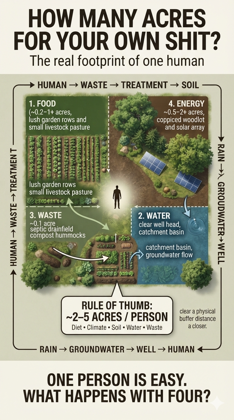
How many acres do you need for your own shit?

A commonly cited homesteading rule of thumb is roughly 2–5 acres per person for a fairly self-sufficient setup—but that’s not a universal number. It depends enormously on your diet, soil, climate, water supply, livestock, energy needs, and how much of your waste you can safely recycle.

And that’s where it gets interesting.

Food production:
You might be able to produce a substantial amount of plant food on a fraction of an acre. Add grains, livestock, dairy, or meat, and the land requirement can increase dramatically.

Water:
You need a reliable source of potable water—and potentially enough watershed, recharge area, storage, or infrastructure to keep that supply reliable.

Waste:
This is the part people tend to overlook.

Your sewage system doesn’t just need a place to put sewage. It needs soil, treatment capacity, separation from groundwater and drinking-water sources, and enough suitable land for the system to function safely.

In Pennsylvania, for example, wastewater land-treatment systems can require significant separation distances from private drinking-water wells. That means the geometry of the property can matter almost as much as the number of acres.

And then there’s the really interesting question:

What if the waste isn’t actually waste?

Humanure, composting systems, graywater, nutrient cycling, orchards, biomass…

At the right scale—and with proper treatment—some things we call “waste” become inputs into another system.

So tonight I’m starting at the smallest possible unit:

One human.

How much land does one human actually need to provide food, water, and a safe place to put—or recycle—everything that comes out of them?

How many acres do you need for your own shit?

Then we’ll scale it up.

Because four people don’t necessarily require four times the land. And four people sharing a watershed, a food system, and a waste-treatment system creates an entirely different problem.

Tonight: micro.
Next: macro.
MACRO

Tonight’s homework assignment: How much land do we need for all our shit?

AKA: The “Who Will Fend for Themselves?” Experiment

Last night was micro: How much land do I need for just me?

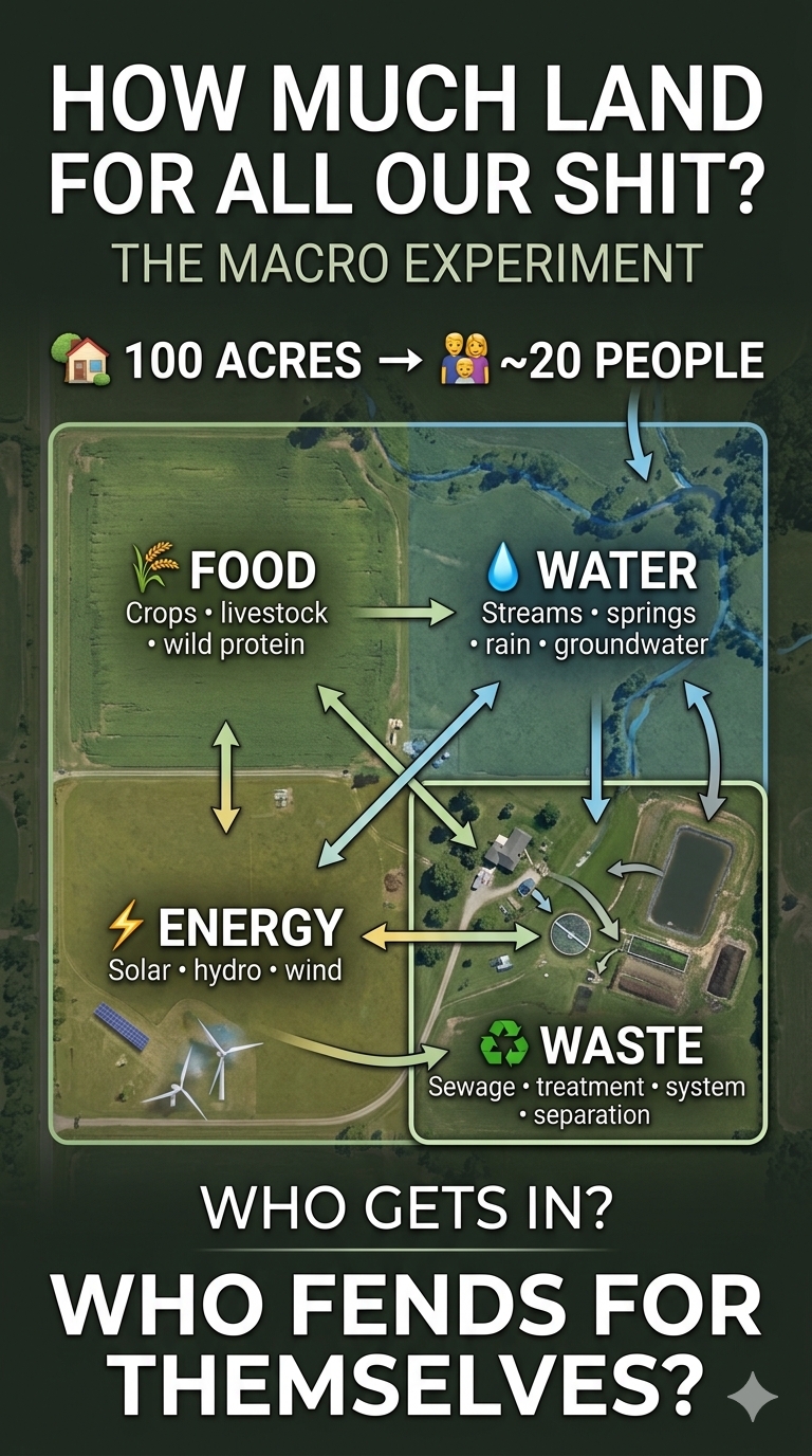
Tonight is macro: How much land do we need for me, my family, and company?

In two different experiments—one in New Zealand and one in Pennsylvania—families have been trying to find the answer.

Interestingly, both case studies arrived at a remarkably similar result: if you can optimize the use of roughly 100 acres, you can support about 20 people, although toward the lower end of what we would consider a modern standard of living.

And that’s when the bigger problem became evident.

As part of our long-term planning, we had to determine who would be allowed to come live with us in a crisis such as climate change.

There were eight of us. We figured our parents would need to be among the first to come. That added six, bringing us to 14. Then we started adding siblings, their partners, and their children. We quickly exceeded 25.

So the real question became:

Who gets invited?

And who is left to fend for themselves?

That sounds like an abstract thought experiment when you have plenty of land, food, water, and energy. It becomes a very different question when those resources have a hard limit. And as climate change accelerates—and the number of grandchildren continues to grow—these questions are no longer really about “future generations.”

They are about our own descendants.

They are the people who may actually have to confront the new realities we are leaving them.

That’s the part of the experiment I find hardest to calculate.

Not how many people the land can sustain.

But who gets to be one of them.
Notes

In New Zealand, Ganantchian Claire said:

Human waste is a very easy “problem “. Composting is super easy, safe, and valuable. Water of course depends where you are. Stream, or roof water are easy gravity fed, groundwater requires energy to bring it up. Food, acreage… as you say, depends entirely on your soil and climate. My opinion is a cow or a couple of goats are the easiest quickest way to get food security as milk covers all your needs. My experience is plants are great, but unreliable as crops can be devastated in a flash by pests or weather events. To avoid starvation, I would never give up my milking cow. One could actually survive with no land at all just walking a cow along the roadsides. A bit extreme, but why not?

In Pennsylvania, USA, I replied:

Nice! Thanks. “Real food” is the hardest thing in my environment as well, especially in the winter. When I say real food, I mean exactly what you said—food security. Eating vegetation is not something I can do for any extended period, and winter makes that particularly difficult.

Though your winters get cooler, I assume they aren’t quite as extreme as Pennsylvania’s, are they?

This becomes particularly relevant when we get to the “macro” experiment.

You also raise another important point with your example of “walking a cow along the roadsides.” In our experiment, we set it up as a game. One of the rules is that you can’t use other people’s land.

That, too, depends on where you live—and on what is considered public property versus private property. Ultimately, I think this is a debate that is likely to intensify as climate migration itself intensifies.

As for waste management, this also appears to be heavily dependent upon location.

In Pennsylvania, the largest long-term problem is waste management, followed by food, then water. But if you don’t manage waste properly, water quickly becomes your biggest problem. Contamination of drinking-water supplies from inadequate or poorly located waste management has been a long-term issue.

Traditionally, you needed at least 10 acres if you could not “perc” your lot.

Collecting rainwater isn’t necessarily a viable solution either. There simply isn’t enough precipitation in many locations across the continental U.S. And in several states, there are legal restrictions on collecting or impeding the flow of water unless you specifically own the water rights.

That’s what makes this experiment so interesting.

The answer isn’t just “How much land do I need?”

It’s where is the land, what can it produce, where does the water come from, and where does the poo go?

How many acres do you have available and how many people do you think you could sustain?

Ganantchian replied:

Interesting conversation. It highlights one of the biggest obstacles to self sufficiency is regulations.

We have 100 acres of land. 25 acres retired to native bush and wetlands, 50 acres very steep of very poor quality soil, 25 acres of which have been planted in poplars. And 25 acres of gently slopping with average quality soil.

I reckon we would comfortably feed 20 people in a localised system ie no fossil fuels or synthetic fertilisers use. Because of the poor inherent quality of our soil, manure from animals and us is the most valuable resource. If composted properly, it is safe to use around fruit and nut trees, which we have planted over 100 over the farm.

Our climate is very mild and with usually good rainfall although we do get drought. Rainwater is vital for drinking as I drunk water from our creek as an experiment and got quite sick 😂 Although it’s fine when boiled.

But again, the biggest hurdle is having to pay land rates. Which at the moment the livery horses cover. They do take up 90% of our grazing land… so currently the farm can only sustain 1 or 2 people… All because we are forced to fund Growth in the region, new roads, infrastructure for cars which I loathe, airport extensions which I vowed to never use again…

Hence it is very difficult to prepare for the unfolding multi crisis while the authorities are impeding our progress.

I responded:

Yes, very interesting indeed. Our macro experiment was intended to demonstrate how many people we could sustain on similar acreage. The result was almost identical.

Two families of four acquired 135 acres. About 35 acres were “public rights of way,” and another 20 acres were steep slopes and other unlivable acreage. Some of those 35 acres consisted of three streams, so potable water wasn’t a problem. One of the streams originated from a spring on the property and tested safe for drinking.

We had a cattle and chicken farmer adjoining the property. We exchanged our tillable acreage, about 65 acres, for him to grow feedstock in exchange for him raising a couple of cows and some chickens for us. There were also fish, small game, deer, and other protein sources. That left us about 15 acres for vegetables.

We did not fully develop and complete the land-management plan because it was not economical at the time. However, we did a thorough plan for being able to survive the winters. Solar panels offered the best and cheapest energy source. Small hydroelectric systems installed in the streams could add additional wattage. In addition, a small windmill could pump water up the steep slope to a small reservoir, which could be used as a “battery” for hydropower when the sun wasn’t shining.

Sewage ended up being the limiting factor.

Without sewage, we could sustain about 38 people. With sewage, that number dropped to about 25. The three streams were great for eating and drinking, but they limited where we could build sewage treatment systems without having rainwater runoff contaminate the drinking water and food sources.

The end result was a self-sustaining property of roughly 100 acres that could provide enough food, water, and energy for 20–25 people.

That is when the bigger problem became evident.

As part of our long-term plan, we had to determine who would be allowed to come live with us in a crisis such as climate change. There were eight of us. We thought our parents would need to be the first to be saved. That was an additional six, bringing the total to 14. If all of our siblings, their mates, and kids were included, we quickly exceeded 25.

So that became the bigger issue.

Who would be on the list of people invited versus the list of people to fend for themselves?

As climate change accelerates and the number of grandchildren grows, these questions are no longer about future generations. They are about our own descendants being forced to confront the new realities they will inherit.

She asked:

did you give up?

Yes, I equally feel that I only can provide for close loved ones. It might become different if our local community wakes up. But so far, most of my neighbors think the crisis is a distant worry for the next generation. I’m more than happy to open my gardens to as many people as possible. As long as they are on the same page, and putting in the hard yards.

People seem to think we have time. But the systems you are describing take years to put into place. 50 years ago is when humanity should have gone down that track.

Now… we barely have time to prepare for our small family groups…

Makes me ponder if I’ve done it in the right place as the local population (walking distance) is about 2000 people. 99% of whom rely entirely on being fed by supermarkets and takeaways…

I replied:

No, we didn’t give up. We achieved the goals of the study.

I was the climatologist, economist, and estate planner, as well as the land-management executive. What became obvious was that the physics, science, and logic of a crisis weren’t going to be the real problem.

The security of the infrastructure from outside threats—and the internal trust required to manage the “financial trust fund”—were going to be the larger crisis within the crisis.

One would hope that a crisis would bring us—humanity—together.

Unfortunately, the opposite appears to be true.

Fear and greed are inherent problems that get amplified in a crisis.

That was probably the most important thing we learned from the experiment.
bookmark_borderTipping Point Season: The Amazon Dieback

by Daniel Brouse and Sidd Mukherjee

Public Access Version: Amazon Dieback Simplified

🌎 TIPPING POINT SEASON: THE AMAZON DIEBACK

The Amazon is more than a rainforest. It is part of Earth’s climate-regulating system—and one of the places where a regional disruption could become a global problem.

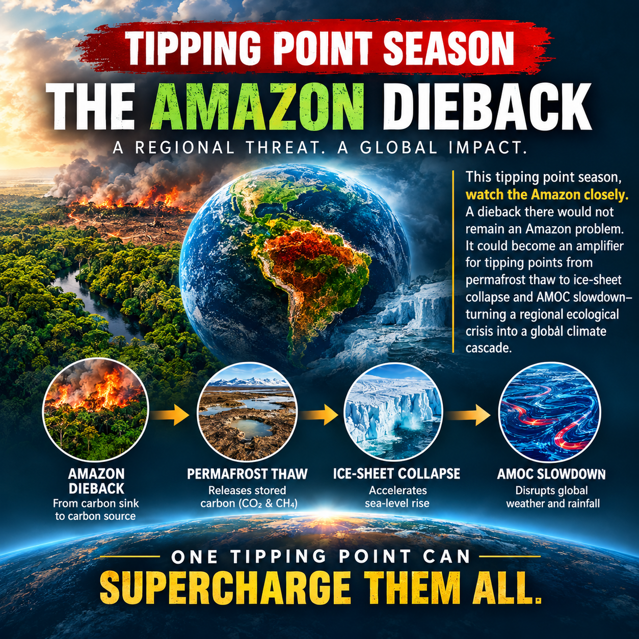
This tipping point season, watch the Amazon closely.

A major Amazon dieback would not remain an Amazon problem.

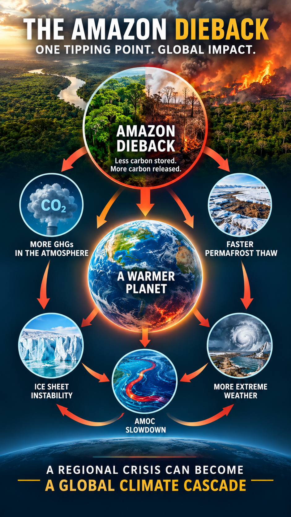
As forests lose resilience, carbon storage can decline, regional rainfall patterns can shift, and warming can intensify. Those changes could interact with other vulnerable parts of the Earth system—from permafrost thaw and ice-sheet collapse to AMOC slowdown.

That is the danger of tipping cascades:

One system destabilizes → amplifies warming and disruption → increases pressure on another → triggers further change.

The result could be a cascade that moves far beyond the Amazon.

🌳 Amazon dieback → carbon loss & rainfall disruption → additional warming → pressure on other tipping systems → global climate cascade

The critical question isn’t simply “Will the Amazon reach a tipping point?”

It is:

What happens when tipping points begin interacting with one another?

🔬 Tipping Point Season: The Amazon Dieback
A closer look at why the Amazon matters—and why what happens there may not stay there.

#TippingPoints #Amazon #AmazonRainforest #ClimateChange #ClimateScience #TippingCascades #Permafrost #IceSheets #AMOC #EarthSystem #ClimateRisk


Full Paper Introduction

The 2023–2024 El Niño was the first recorded instance of the Amazon shifting from a carbon sink to a net emitter. This makes Amazon dieback one of the most concerning climate tipping points. Some tipping points, such as coral reef die-off, though deeply concerning, have less of an amplification effect on climate change. The Amazon, however, is far more consequential. As its forests deteriorate, the Amazon can become one of the largest self-amplifying feedback loops in climate collapse.

The 2023–2024 El Niño

Brazil’s Pantanal wetlands are famous for their extraordinary biodiversity. There were 2,387 fires in the Pantanal during the first 13 days of November 2023—an increase of more than 1,000 percent from the entire month of November the previous year, according to satellite monitoring by the Brazilian space research agency INPE.

“The situation is completely out of control. And between the heatwave and the wind, it’s only going to get worse,” said biologist Gustavo Figueiroa, head of the environmental group SOS Pantanal.

What do you know about the Rio Negro as it relates to climate change and carbon sinks?

The Rio Negro gets its name from the color of its water. Its black water is caused by highly acidic, carbon-rich organic material. One scientist who lives on the river has compared its appearance to Coca-Cola. In 2023, the Rio Negro recorded record-low water levels.

Most of the carbon discharged into the water helps carbon eventually sink into the ocean, effectively contributing to a carbon sink. Lack of rain and drought conditions, however, result in more vegetation dying and contribute to a feedback loop: more plants die from reduced rainfall, while there is less rain to wash excess carbon toward the river system and ultimately into the ocean. The result is less carbon being removed from the atmosphere, contributing to additional global warming and further vegetation loss.

From March 16 through 18, 2024, Brazil experienced a severe heatwave, setting new records in Rio de Janeiro, with a reported wet-bulb temperature reaching 62.3 degrees Celsius (144.1 degrees Fahrenheit). Wet-bulb temperature reflects the body’s ability to cool itself through the evaporation of sweat. As heat and humidity increase, sweat evaporates less effectively, making it more difficult for the body to regulate its core temperature. A wet-bulb temperature of 35°C (95°F) at 100% humidity, or approximately 115°F at 50% humidity, represents the upper limit of safety, beyond which the human body cannot effectively regulate its core temperature through sweat evaporation.

On March 23, an atmospheric river event brought heavy rains to Brazil’s Rio de Janeiro state, resulting in at least nine fatalities, primarily in Petrópolis, which bore the brunt of the impact. An astonishing 270 mm (11 inches) of rain fell within a 24-hour period, significantly affecting the region and leading to numerous incidents, including landslides and house collapses.

Contributing Causes

The Amazon is under stress from multiple sources: ground-level ozone and carbon drawdown, deforestation, and climate-circulation breakdown.

A key and increasingly important feature of the observational record is that multiple climate and ecological indicators in the Amazon appear to be shifting into what can be described as “jerk” behavior—dynamics in which not only the state of the system is changing, but the rate of change itself is changing. In mathematical terms, this corresponds to increasing higher-order derivatives of system behavior, where acceleration is no longer stable but itself accelerates over time.

In practical terms, jerk behavior is observed when systems transition from relatively smooth or predictable trajectories into regimes characterized by rapidly compounding variability, abrupt shifts, and feedback amplification. In the Amazon context, this is suggested by signals such as increasing volatility in precipitation extremes, faster transitions between drought and recovery states, and weakening resilience following disturbances such as heat stress or fire events.

The 2026–2027 El Niño Amplifier

The Amazon is the most directly impacted tipping point from the 2026–2027 El Niño.

Amazon Rainforest Dieback — Most Directly Affected

Mechanism: Walker Circulation disruption

Warm ENSO phases shift the atmospheric ascent zone eastward into the Pacific, driving intense and prolonged atmospheric subsidence—dry air—over northern and central South America. This causes severe droughts, heatwaves, and fire outbreaks that exhaust soil moisture and degrade the forest toward a savanna-like state.

A developing super El Niño is compounding severe historical drought and deforestation stress, pushing the Amazon rainforest dangerously close to an irreversible dieback tipping point.

Current Pressures

Delayed Rains: The El Niño event threatens to delay the wet season.

Dry-Season Peak: Scientists expect El Niño to peak between October and December. This timing leaves forest undergrowth tinder-dry when river levels are lowest.

Loss of Resilience: Decades of logging and warming mean large parts of the forest take much longer to recover from seasonal dry spells.

Tipping Point Risks

Savanna Transition: Continuous dry shocks risk converting rich rainforest into open savanna.

Carbon Reversal: Stressed trees release massive amounts of carbon instead of storing it, accelerating global warming.

Unprecedented Threat: The combination of a super El Niño with rising greenhouse-gas concentrations creates an extreme and potentially unprecedented danger for the Amazon basin.

Human and Environmental Toll

Inhabited Areas Hit: Data highlights that more than 38% of human settlements in the Amazon experienced high exposure to recent El Niño droughts, as reported by Agência Brasil.

Megafire Risks: Hotter and drier conditions sharply increase the threat of uncontrollable wildfires that can damage primary forest areas.

Conclusion

The Amazon is not an isolated tipping point. Its potential dieback is dangerous precisely because it can amplify other tipping points across the Earth system.

As the rainforest loses biomass and its capacity to absorb carbon declines, more greenhouse gases remain in the atmosphere. At the same time, drought, heat, and fire can turn portions of the forest from a carbon sink into a carbon source. That additional warming does not stop at the borders of the Amazon. It adds pressure to already-stressed climate systems around the world.

The feedbacks can extend from tropical forests to permafrost. Additional warming accelerates permafrost thaw, releasing carbon dioxide and methane and creating another source of atmospheric warming. That warming further increases pressure on ice sheets, contributing to sea-level rise and potentially accelerating the destabilization of Greenland and West Antarctica.

The same warming also affects the ocean and atmospheric circulation. Changes in temperature, precipitation, and freshwater input can weaken major circulation systems such as the Atlantic Meridional Overturning Circulation (AMOC). A weakening AMOC can, in turn, alter rainfall patterns, ocean heat distribution, and regional climate, adding further stress to other tipping elements.

This is what makes the Amazon particularly important. A tipping point does not have to topple the entire climate system by itself. It can help push other systems closer to their thresholds. Once several tipping elements begin reinforcing one another, the Earth system can move from individual disruptions toward a cascading sequence of self-amplifying changes.

The Amazon therefore represents more than the potential loss of a rainforest. It represents the possibility of activating another major component of a global climate feedback network—one that can intensify warming, weaken resilience elsewhere, and make previously distant tipping points more likely to be crossed.

This tipping point season, watch the Amazon closely. A dieback there would not remain an Amazon problem. It could become an amplifier for tipping points from permafrost thaw to ice-sheet collapse and AMOC slowdown—turning a regional ecological crisis into a global climate cascade.

bookmark_borderScientists Using AI: From Computational Efficiency to Climate Innovation

by Daniel Brouse and Sidd Mukherjee

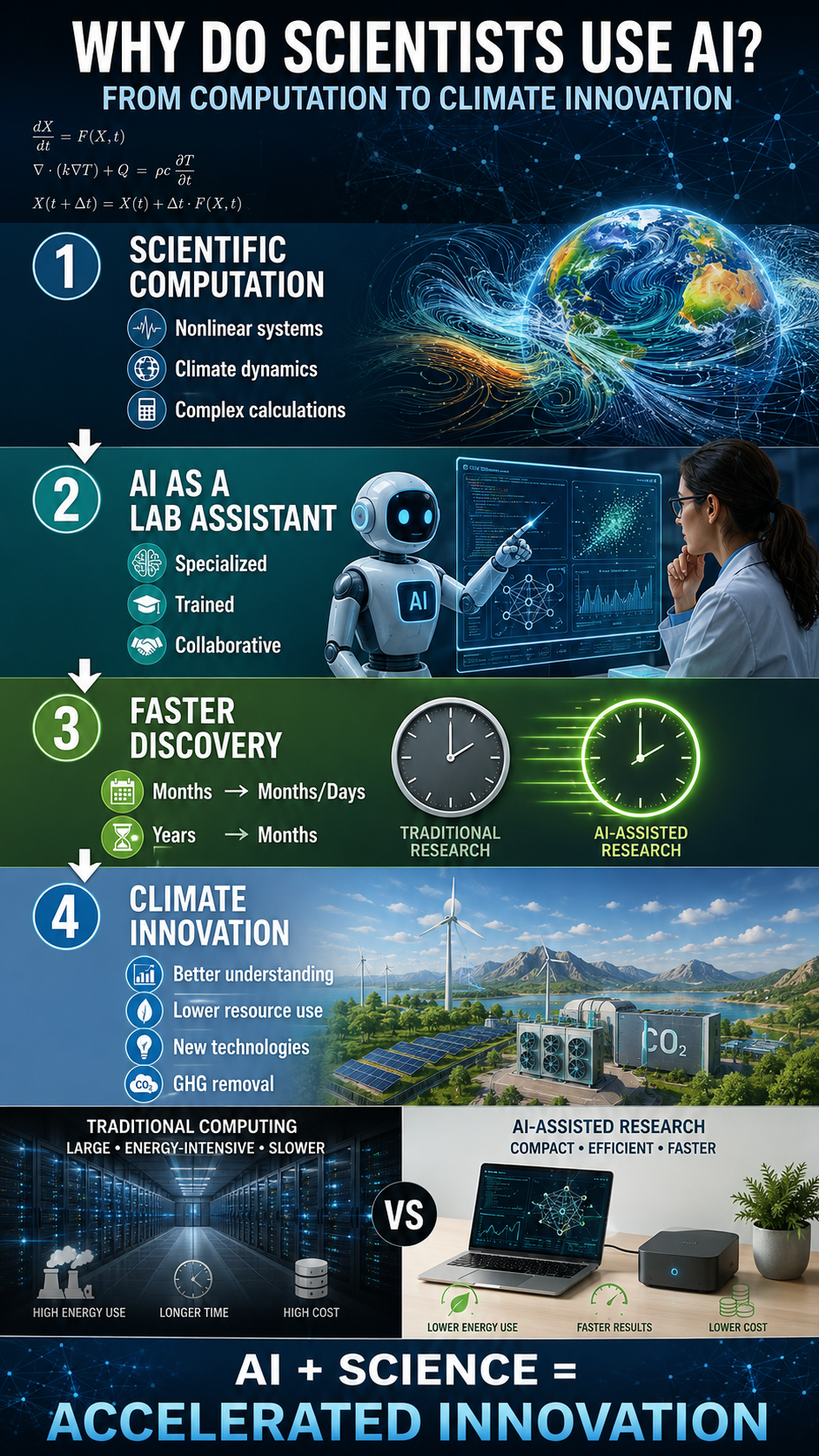
Why Do Scientists Use AI?

The short answer is:

We’ve conducted case studies on the use of AI in a wide variety of environments, including everything from the dynamics of nonlinear chaotic systems to songwriting and musical production.

All produced similar results—benefits to the environment, the economy, and society.

For instance, the climate education and graphics used for this post are based on this scientific paper as well as the publicly accessible version.

If I had created them manually, the costs in time, labor, energy, and resources would have been substantial. Using AI, the direct dollar cost to me was effectively zero, the graphics were generated in about a minute, and the estimated natural-resource cost was roughly $0.067 per image.

By comparison, producing similar graphics through traditional methods could easily have cost hundreds of dollars when accounting for labor, software, revisions, and associated natural-resource use. Mathematically, the AI-generated version required approximately 0.005% of those resources—just five thousandths of one percent of the traditional cost. These savings are equivalent to a reduction in environmental impact.

The benefits—in both environmental savings to the planet through reduced physical-resource use and in the ability to produce and distribute education—far outweigh the costs.

Most importantly:

The only effective way to stop the acceleration of climate change is through the reduction of fossil-fuel combustion.

However, the most likely way of reversing the trajectory of climate change is through people using AI to develop previously unthought-of methods and technologies that can fundamentally change how we produce, consume, and manage resources—and potentially remove greenhouse gases from the atmosphere.

Anti-Science and Technology Rhetoric

Unfortunately, the lack of science and technology literacy is at the root of many of society’s problems. Anti-AI opinions are ironically very similar to the anti-science rhetoric used by climate-change deniers.

Climate-change deniers tend to have little, if any, experience as climate scientists. They often show signs of impaired executive function: the brain’s ability to plan, analyze, and think abstractly. This makes processing complex or nuanced information nearly impossible, fostering an aversion to science, mathematics, and logic. Their thinking becomes rigid, emotionally driven, and black-and-white, leaving them highly susceptible to political propaganda, conspiracy theories, and fear-based messaging. Unable to reason critically or tolerate uncertainty, they cling to misinformation and reject rational discourse—no matter how much evidence is presented.

The same holds true for anti-technology opinions expressed in public. The ill-informed individual has likely never used AI in the role of a climate scientist. Scientists train their own highly specialized AI assistants. AI is artificial SUPPLEMENTAL intelligence. This is not how the ordinary individual usually interacts with AI.

In my case, I have spent years developing multiple specially trained “lab assistants” that have learned from scores of our own work. When Sidd and I started, our work had to be done on Ohio State computers and supercomputers that Sidd helped create. Things like “a floating decimal” were, and still are, a significant problem. Problems that needed solving would take months or years to process. The amount of energy spent on computation was enormous compared with today.

Things have changed for the better.

This year, we were able to establish third-derivative behavior across multiple climate indicators—extremely important developments in climate science that confirm that the acceleration rate of climate change is itself accelerating. This work was completed within four months. Historically, I would have been unlikely to complete this work in my lifetime if it were not for AI.

In the meantime, the United States has gone extremist in anti-science and anti-technology ideology, much to the detriment of science and scientists in the U.S. In fact, we are now working on bringing up our own AI computer using Chinese technology. It will be running on DeepSeek. The single computer will do the work of what used to take at least a dozen servers to accomplish, at a fraction of the price. It will not be run in a data center. It will not be costing society anything. In fact, it will be greatly benefiting society and helping to solve the climate crisis.

So, the next time you want to voice your opinion about AI, do your homework first. Start by getting at least a master’s-level education in climate science. Then spend years training your AI assistants. After completion, I would be happy to discuss AI with you.

bookmark_borderTipping Point Season: Greenland Simplified

🌎 TIPPING POINT SEASON: GREENLAND

What does a tipping point actually look like?

It may look less like one dramatic event—and more like a system changing, feedback by feedback, until the changes begin reinforcing one another.

That is what makes Greenland so important.

Greenland has now experienced 30 consecutive years of ice loss.

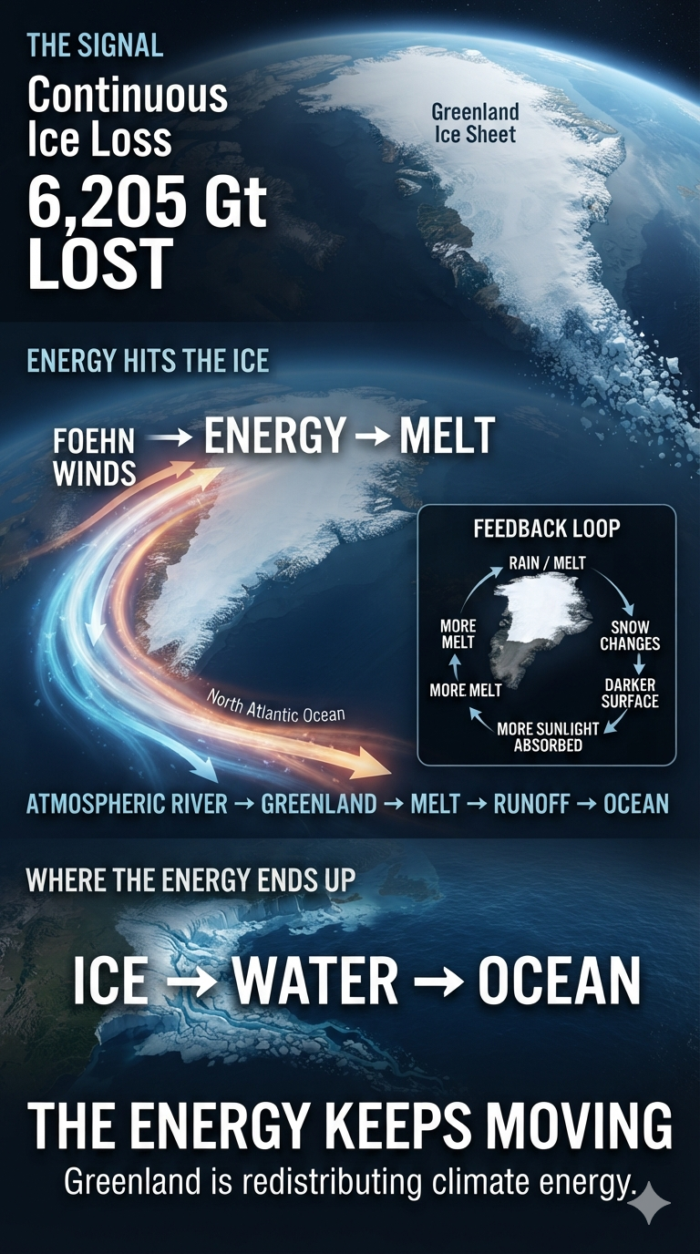
From 1986/87 through 2025/26, approximately 6,205 gigatons of ice have disappeared—contributing about 17.4 millimeters to global sea-level rise.

But the most important story isn’t simply the amount of ice that has melted.

It is where the climate energy is going.

🔥 Warmer air carries more moisture.

🌧️ Atmospheric rivers transport that moisture and heat toward Greenland.

💨 Topography can transform those atmospheric rivers into powerful foehn winds.

🌡️ Rain and warm air increase melting.

❄️ Snow and ice are transformed.

☀️ Darker surfaces absorb more solar energy.

💧 More meltwater runs toward the ocean.

🌊 Freshwater enters the North Atlantic and can interact with ocean circulation.

One process connects to another.

And another.

And another.

This is the essence of Tipping Point Season.

Climate change isn’t simply a thermometer rising.

It is an interconnected planetary system processing enormous amounts of additional energy.

Greenland is one place where we can watch that energy being transformed into physical change.

The 6,205 gigatons of ice already lost are the accounting entry.

The atmospheric rivers, heat, rainfall, melting, runoff, circulation, and sea-level rise are the transactions.

And the feedbacks connect them.

🌎 One planet.

🔥 One interconnected climate system.

⚠️ And potentially, a season of tipping points.

Read “Greenland: Gigatons Gone” and see how climate energy moves through the system—and what it hits next.

This is Tipping Point Season

bookmark_borderA Simplified Introduction to Tipping Point Season

🌎 TIPPING POINT SEASON

What if climate change isn’t simply about a planet getting warmer?

What if we are entering a period when multiple climate tipping points begin activating, interacting, and amplifying one another?

That is the argument behind the paper, “Tipping Point Season.”

The first tipping point season emerged in 2023–2024, when global temperatures exceeded +1.5°C for an extended period and nine major tipping points became observable.

Now, in 2026, the climate system is showing something even more important: connections.

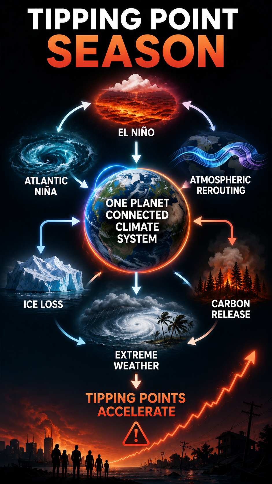
A Pacific El Niño can influence atmospheric circulation. Atmospheric circulation can alter the Atlantic. Ocean changes can modify moisture, convection, and storms. Feedbacks propagate across the planet.

The climate system is not a collection of isolated parts.

It is one interconnected system.

And that changes how we should think about the 1.5°C threshold.

1.5°C is not a magical temperature at which everything suddenly changes.

It is a tripwire—a point beyond which the probability of triggering major tipping points increases, while feedbacks can begin accelerating, compounding, and cascading through the system.

The critical question is no longer simply:

“What happens as the planet gets warmer?”

It is:

“What happens as we cross the tripwires?”

🔥 Tipping Point Season explores what happens when climate feedbacks stop behaving like isolated processes and begin behaving like a coupled planetary network.

One planet. One interconnected climate system. And potentially, a season of tipping points.

This is Tipping Point Season

bookmark_borderTipping Point Season

by Daniel Brouse

Introduction: What Is Tipping Point Season?

The first tipping point season was 2023–2024, when global temperatures exceeded +1.5°C for an extended period. During that season, nine tipping points became observable:

  • Greenland Ice Sheet Collapse
  • West Antarctic Ice Sheet Collapse
  • Labrador–Irminger Seas/SPG Convection Collapse
  • East Antarctic Subglacial Basins Collapse
  • Arctic Winter Sea Ice Collapse
  • East Antarctic Ice Sheet Collapse
  • Amazon Rainforest Dieback
  • Boreal Permafrost Collapse
  • Atlantic Meridional Overturning Circulation (AMOC) Collapse

This phenomenon occurred simultaneously with El Niño. ENSO is not a cause of climate change; rather, it is a manifestation of the climate system’s accumulated energy. Most of that accumulated climate energy is stored in the oceans. Every several years, much of this heat is brought toward the surface in an oscillating pattern.

Over the last 30 years, El Niño events have continued to occur at their historical frequency of roughly every 2 to 7 years, but their intensity has dramatically increased. A recent August 2026 study by the University of Michigan revealed that El Niño events have become nearly 40% stronger over the last few decades compared with the pre-industrial era.

The last 30 years have borne witness to three of the most powerful “Super El Niño” events in recorded history, alongside an exceptionally strong event currently unfolding in 2026. The extreme heat released by this “supersized” El Niño is expected to temporarily push the entire planet above the 1.5°C global warming limit by late 2026 and into 2027.

A Planetary Feedback Network

This tipping point season is pushing the climate system even further, with traditionally non-connected tipping points and feedbacks beginning to couple with one another. One example is the coupling of a Pacific El Niño and an Atlantic Niña.

Usually, the Pacific and Atlantic pretty much “do their own thing.” But this year is different. The climate system has been supercharged with energy, and that energy is manifesting in some strange and surprisingly interconnected ways. The unusual co-occurrence of a Pacific El Niño and an Atlantic Niña illustrates how strongly connected Earth’s climate system is. Although the Pacific and Atlantic are separate ocean basins, the atmosphere links them through planetary-scale circulation patterns.

The deeper significance is the connection itself.

A thermal anomaly in the Pacific can reorganize tropical convection. That atmospheric reorganization can propagate through the global circulation system, altering pressure and winds over the Atlantic. Those winds can change ocean upwelling and sea-surface temperatures. The resulting ocean anomaly can then modify atmospheric moisture, convection, and storm development.

The signal can extend even farther through the North Atlantic jet stream and atmospheric wave patterns, influencing weather regimes across Europe and the United Kingdom.

This is not a single atmospheric current traveling around the planet. It is a coupled network of atmospheric and oceanic responses operating across different spatial and temporal scales.

What begins as: PACIFIC WARMING

became: ATMOSPHERIC REROUTING

then: ATLANTIC COOLING

and ultimately:

REGIONAL WEATHER + HYDROCLIMATIC CONSEQUENCES

The climate system is therefore not a collection of isolated ocean basins and weather systems. Energy moves through the connections. The atmosphere carries the signal. The oceans respond. Feedbacks propagate. One planet. One interconnected climate system.

This tipping point season makes observable, for the first time in history, the coupling, interaction, and amplification of feedbacks—and their collective pushing of tipping points into their second derivation.

bookmark_borderTipping Points That Toppled

When Climate Feedbacks Stop Looking Theoretical

By Daniel Brouse

The 2023–2024 El Niño event made observable what had previously been discussed largely as theoretical: multiple climate-system tipping processes were being pushed simultaneously.

At least nine potential tipping points were being knocked or pushed toward critical thresholds during the 2023–2024 period. Two of the clearest examples were global coral reef degradation and accelerating permafrost instability.

What has happened since is even more significant.

The 2026–2027 El Niño is now developing on an Earth system that is already substantially warmer and more stressed than it was during the previous major El Niño. NOAA reported in August 2026 that El Niño was strengthening, with a greater than 90% probability of a very strong event during the Northern Hemisphere fall and winter of 2026–27. NOAA also estimated a 69% probability that October–December 2026 would produce a historic event exceeding +2.5°C in the three-month Relative Oceanic Niño Index—a level exceeding previous El Niño events dating back to 1950.

This matters because tipping behavior does not occur in isolation.

A system that has already been weakened can respond very differently to the next pulse of heat.


The 2023–2025 Coral Reef Collapse

The massive global coral bleaching event that began in 2023 and extended through 2025 was not simply another bad year for coral.

NOAA confirmed in April 2024 that the world was experiencing its fourth global coral bleaching event on record, and the second in only ten years. By the time NOAA’s assessment was updated in 2026, bleaching-level heat stress had affected approximately 84.4% of the world’s coral reef area, with mass bleaching documented across at least 83 countries and territories. NOAA characterized it as the largest global bleaching event on record.

The significance is not merely the percentage of reefs exposed to heat.

Coral reefs depend upon a narrow thermal range. Extreme heat disrupts the relationship between coral animals and the symbiotic algae that supply much of their energy. Bleaching therefore represents a fundamental physiological failure, not simply a change in color.

When extreme heat persists, bleaching can progress to starvation, disease and mortality. And recovery requires time. That is where the feedback becomes dangerous.

If reefs are repeatedly exposed to severe marine heatwaves before they have recovered, the system can move from temporary disturbance to structural ecological degradation. A reef that loses living coral loses the biological architecture that supports fish, coastal protection, biodiversity and future coral recruitment.

The recovery window is shrinking.

A 2026 assessment by the Global Coral Reef Monitoring Network found that the average interval between mass bleaching events has fallen to roughly five or six years, while coral cover during 2020–2024 was approximately 9.5% below historical averages. The 2023 event alone affected an estimated 77% of global reef area, according to the assessment.

The crucial point is that the next El Niño does not begin with the coral system restored to its previous condition.

It begins with an already damaged system.

And now the Pacific is heating again.


The 2026–2027 El Niño

The present El Niño is not hypothetical.

NOAA reported in August 2026 that sea-surface-temperature anomalies in the eastern equatorial Pacific had exceeded +2°C, while subsurface temperature anomalies reached approximately +10°C at depth. The agency reported a greater than 90% probability of a very strong El Niño during the 2026–27 Northern Hemisphere fall and winter.

By August, sea-surface temperatures in parts of the eastern equatorial Pacific were near or above +3°C, with a Niño-3.4 weekly index around +1.8°C.

This is precisely why the timing matters.

The planet is not resetting between El Niño events.

Heat accumulates in the climate system. Oceans retain enormous quantities of that energy. Ice sheets lose mass. Permafrost thaws. Forests burn. Coral reefs experience repeated thermal stress. Ecosystems lose resilience.

The next disturbance therefore acts upon a system already pushed closer to its limits.

That is how tipping behavior becomes possible.


Permafrost: The Other Domino

The same basic principle applies to permafrost.

Permafrost is not simply frozen dirt.

It is a massive reservoir of organic carbon accumulated over thousands of years. When frozen ground thaws, microbes gain access to previously locked organic material. They decompose it and release carbon dioxide and, under oxygen-poor conditions, methane.

That creates a feedback:

warming → thaw → microbial decomposition → greenhouse-gas emissions → additional warming → additional thaw.

But that is only one part of the process.

Permafrost is also physically coupled to vegetation, soil moisture, hydrology, fire, snow cover and ground ice.

Once those connections begin changing rapidly, the response can become nonlinear.


The “Compost Bomb” Effect

One of the most striking mechanisms is what can be called the “compost bomb” or self-heating effect.

When previously frozen organic matter thaws, microbial decomposition accelerates. Decomposition is an exothermic process: biological activity releases heat. That heat is not large enough to explain Arctic warming by itself, but locally it can become part of a reinforcing thermal environment.

That warming activates biological processes that themselves produce heat and greenhouse gases inside a system already undergoing thermal destabilization.

The frozen carbon reservoir is effectively being converted from a long-term carbon store into an active component of the carbon cycle.


Water Carries the Heat

Rain and changing hydrology provide another pathway.

Permafrost responds not only to air temperature but to the movement of heat through the ground.

Warm rain can penetrate the active layer and transport heat downward. Changes in snow, soil moisture, drainage and groundwater can alter how efficiently heat is stored and transferred through frozen ground.

The result is a system in which atmospheric warming, precipitation, hydrology and ground temperature interact.

This is particularly important because the response is not necessarily gradual.

Research on abrupt permafrost thaw has shown that collapsing ground, rapid erosion, landslides and thermokarst can expose large quantities of previously protected carbon much faster than gradual thaw models assume. Abrupt thaw may occur across less than 20% of the permafrost zone yet potentially affect roughly half of its stored permafrost carbon.

That is a tipping mechanism.

Not because every square mile of permafrost suddenly disappears, but because a relatively limited area of abrupt thaw can have a disproportionately large effect on the carbon cycle.


Thermokarst: When Frozen Ground Loses Its Structure

Permafrost is also a structural system. Ice binds soil and sediment together. When that ice melts, the ground can collapse.

The result is thermokarst—a landscape of subsidence, ponds, lakes, gullies and collapsing terrain.

This can expose deeper layers of ancient carbon, including carbon-rich deposits such as Yedoma, to oxygen, microbes, water and atmospheric processes.

The important distinction is between gradual thaw and abrupt thaw.

Gradual thaw progressively deepens the seasonally thawed active layer. Abrupt thaw can physically destroy the ground.

That difference matters enormously.

Once the ground collapses, hydrology changes. Lakes form or drain. Slopes destabilize. Sediment moves. Previously protected organic material becomes exposed.

The carbon cycle has effectively changed gears.


Fire Removes the Insulating Blanket

Then there is fire.

The extraordinary Canadian and Siberian wildfires of recent years are not merely consequences of Arctic warming. They can also become mechanisms that accelerate permafrost degradation.

The surface vegetation, moss and peat layer acts as an insulating blanket. Fire removes that blanket. The exposed soil can absorb substantially more solar energy, increasing ground temperatures and deepening the active layer.

The effect can persist for decades.

Research in Canadian permafrost peatlands has found that wildfire impacts on the soil thermal regime can persist for approximately 30 years, with burned areas experiencing warmer and deeper active layers and accelerated thermokarst development.

The relationship works in both directions.

Warming promotes fire.

Fire promotes permafrost thaw.

Thaw can promote soil drying and further fire.

Recent modeling research published in Nature Communications found that rapid permafrost thaw can produce abrupt changes in soil hydrology, surface warming and atmospheric dryness that intensify Arctic and sub-Arctic wildfires, particularly in western Siberia and Canada.

This is not a single feedback loop.

It is a network of feedback loops.


The Zombie-Fire Connection

The most disturbing manifestation is the phenomenon popularly called the “zombie fire.”

Peat and organic soils can continue smoldering beneath the surface after the visible flames disappear. These fires can survive through winter and re-emerge when conditions become favorable.

That means a previous year’s fire can effectively become the seed for the next year’s fire. The system acquires memory.

And that matters because climate tipping behavior often involves precisely this kind of persistence: the system does not return to its previous state when the original disturbance ends.

The fire changes the ground. The changed ground changes the next fire. The next fire changes the ground again.

Meanwhile, the carbon released by both combustion and thaw adds additional greenhouse gases to the atmosphere.

The 2023 Canadian fire season demonstrated the scale of this problem. A Nature study estimated approximately 647 million tonnes of carbon (647 TgC) were emitted by Canadian fires from May through September 2023—comparable to the annual fossil-fuel carbon emissions of a major industrial nation. The burned area was more than seven times the average annual area of the preceding four decades.

The climate system is therefore not merely warming the Arctic.

It is increasingly capable of removing the mechanisms that kept the Arctic frozen.


Then Came Nepal and Tibet

And this brings us to the next level of the argument.

On August 26, 2026, a massive collapse occurred in the Nepal–Tibet border region.

A glacier and associated rock mass collapsed from approximately 5,200 meters, sending ice, rock, sediment and water cascading more than 1,200 meters into the valley below. The resulting event produced a catastrophic flash flood through the Bhotekoshi and Trishuli river systems.

The scale was extraordinary.

By September 3, more than 1,200 people had been reported dead in Nepal, thousands remained missing, entire communities had been destroyed, and thousands of homes had been destroyed or rendered uninhabitable.

It might be premature to claim that the 2026 El Niño directly caused the Nepal–Tibet collapse. The scientific investigation is still developing. But that does not make the event irrelevant to tipping-point dynamics.

Quite the opposite.

It demonstrates what happens when multiple components of a cryospheric system become unstable simultaneously.

Glacier.

Rock.

Water.

Permafrost.

Slope stability.

River system.

Infrastructure.

One failure can trigger another.

That is the essence of a tipping cascade.


The Second Derivative of the Problem

The August 26, 2026 Nepal–Tibet event was something more than simply another climate disaster.

The first derivative is change. The second derivative is acceleration of change.

But there is another level beyond acceleration:

the coupling of changes.

A glacier loses mass. Permafrost warms. Ground ice melts. Water penetrates fractures. The frozen material that once helped bind rock and soil together loses strength. Slopes become unstable. Rock loses support. Glacial ice moves. A glacier, rock mass, or entire mountainside collapses. The collapse mobilizes ice, water, sediment and debris. The resulting torrent can destroy roads, bridges, vehicles, homes and entire sections of river valleys.

One destabilized component triggers another.

That is a tipping cascade.

And this is precisely why treating every tipping point as an isolated phenomenon misses the larger danger.

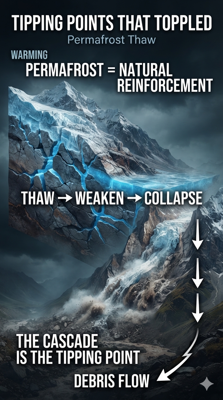
Permafrost Is the Glue

Following the catastrophic August 26, 2026 bedrock failure and glacier collapse along the Nepal–Tibet border near Langtang Lirung, geomorphologists have increasingly scrutinized the role of high-altitude permafrost in mountain stability.

In high-altitude alpine environments such as the Himalayas, permafrost is not merely frozen soil. It can function as a critical structural component of the mountain itself.

Ice within fractures, rock pores and sediment acts as a natural cement. Frozen ground can increase the mechanical strength of slopes and help stabilize otherwise extremely steep terrain. When that ground warms and the ice melts, the mechanical properties of the mountain change.

The mountain does not simply become warmer.

It becomes structurally weaker.

That distinction is fundamental.

For thousands of years, freezing temperatures helped lock together rock, sediment, ice and soil. Climate warming attacks that system from multiple directions simultaneously. Higher air temperatures warm the ground. Changing snow cover alters the insulation of the surface. Meltwater and rainfall can penetrate fractures. Repeated freeze–thaw cycles weaken rock. And as permafrost ice melts, the frozen bonds that previously helped hold the landscape together disappear.

The result can be progressive destabilization followed by abrupt failure.

This creates a particularly dangerous feedback:

warming → permafrost thaw → loss of structural strength → slope instability → collapse → debris and water mobilization → downstream destruction.

And the process does not necessarily stop at the first collapse. A collapsing glacier can destabilize rock. A rock avalanche can displace enormous quantities of water. Water can erode and destabilize additional slopes. Sediment can transform a river into a rapidly moving debris flow. The debris flow can destroy infrastructure and alter the river channel. A newly formed blockage can create a temporary lake that becomes another hazard when it fails.

In other words, the mountain itself can become a chain reaction.

The Permafrost Connection

This is where the Nepal–Tibet event becomes particularly important to the broader tipping-point argument.

Permafrost is one of the hidden components of the cryosphere. Unlike a retreating glacier, its destabilization is often invisible until the physical structure it supports begins to fail.

You may not see permafrost disappearing. You see what happens after it disappears. You see rockfalls. You see landslides. You see collapsing slopes. You see thermokarst. You see rivers suddenly carrying enormous quantities of sediment. And, in extreme cases, you see entire mountainsides transform from solid terrain into a rapidly moving mixture of rock, ice, water and soil.

That is why the Nepal–Tibet collapse can be viewed as a possible second-order manifestation of cryospheric destabilization.

The first-order effect is warming. The next effect is permafrost degradation. The next is loss of structural integrity. Then comes cascading physical failure. The climate signal has effectively been converted into mechanical energy.

Frozen ground becomes unstable ground.

Stable ground becomes a landslide.

A glacier becomes a flood.

A mountainside becomes a river of debris.

That is what makes tipping cascades so different from ordinary linear climate change. The danger is not simply that each component changes. The danger is that the components are connected. Permafrost can be the glue holding the system together.

Remove the glue, and the pieces do not merely move independently.

They can bring each other down.

This is the second derivative of the problem:

not merely that the climate is changing, and not merely that the rate of change is accelerating, but that increasingly unstable components are beginning to interact in ways that amplify one another.

And when those interactions become visible as collapsing mountains, cascading glaciers, flash floods and debris flows, the tipping point is no longer something we have to imagine.

You can watch it happen.


Climate Energy Becomes Fluidized

There is something visually profound about events like this. Climate energy is normally discussed in abstract units: joules, watts per square meter, degrees Celsius. But once enough energy accumulates in the Earth system, its consequences become physical.

Ice melts.

Rock fractures.

Slopes collapse.

Water accelerates.

Sediment becomes a moving fluid.

Rivers jump their banks.

Roads disappear.

Bridges are ripped from their foundations.

Cars, homes, trees and entire sections of mountains can become part of a single moving mass.

You can literally watch stored climate energy being converted into motion.

That is the part that makes these events so difficult to dismiss as theoretical.


From the Arctic to Pennsylvania

The connection is not confined to the Arctic.

When smoke from the Canadian wildfires descended into Pennsylvania in both 2023 and 2026, the feedback was no longer an abstract Arctic phenomenon. It became observable from the ground. People who had never seen the Arctic could see the consequences of an increasingly unstable northern climate hundreds or thousands of miles away.

The smoke was a visible atmospheric connection between a rapidly changing high-latitude system and everyday life in the northeastern United States.

That is another characteristic of cascading climate disruption:

distance stops protecting us.


The Dominoes Are Already Moving

This is ultimately “tipping points that toppled” means. A tipping point is often imagined as a single dramatic moment when a system suddenly crosses a line. Earth systems are rarely that simple. They are networks.

Coral reefs are connected to ocean temperature, marine heatwaves, disease, ocean chemistry and ecological recovery.

Permafrost is connected to air temperature, snow, vegetation, soil moisture, microbial activity, hydrology and fire.

Glaciers are connected to temperature, precipitation, meltwater, rock stability, permafrost and downstream hydrology.

These systems interact.

A destabilized system can therefore push another system toward instability.

That is the real danger.

The 2023–2025 coral bleaching catastrophe demonstrated how quickly a global ecosystem can be subjected to unprecedented simultaneous heat stress. The permafrost-fire relationship demonstrates how warming can activate feedbacks that reinforce the original warming. The 2026 Nepal–Tibet catastrophe demonstrates how instability within a cryospheric system can cascade through ice, rock, water and infrastructure.

And the 2026–2027 El Niño is now arriving on top of all of it.

NOAA’s current assessment gives this El Niño a greater than 90% probability of becoming very strong, with a substantial probability of reaching historic strength. We should therefore stop asking only:

“Has a tipping point been crossed?”

The more important question is:

“How many systems are already unstable enough that the next disturbance can push them into a new state?”

Because that is what tipping cascades look like. Not one domino. A row of them. And increasingly, we can watch them fall.

They are no longer merely theoretical.

They are observable.

They are physical.

And they are happening now.

bookmark_borderTipping Point Season: Permafrost Thaw Simplified

by Daniel Brouse

Tonight’s homework assignment: Tipping Point Season.

Now that we’re deep into Tipping Point Season, my first assignment was to identify the most observable tipping points emerging this season and compare them with what we were seeing last season.

Tonight’s publishing is Permafrost Thaw: The Sequel.

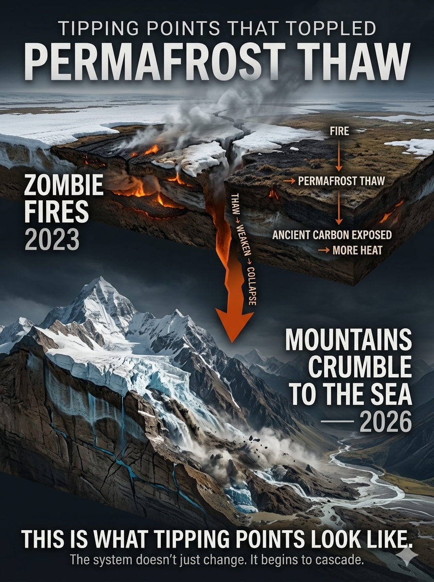
The first chapter was the 2023 warning signal: zombie fires—wildfires that persisted underground through winter and re-emerged as the frozen landscape thawed. 🔥

The sequel is 2026: mountains crumble to the sea. 🏔️🌊

This is the “Second Derivative of the Problem”—when permafrost thaw moves beyond a change in temperature and begins changing the physical stability of the landscape itself.

As frozen ground loses its structural strength, rock fractures, slopes destabilize, and glacier ice, rock, water, sediment, and permafrost can become part of the same cascading failure.

The graphic tells that story in two acts:

🔥 2023 — ZOMBIE FIRES STARTED
Permafrost and carbon-rich ground begin releasing stored heat and carbon. A serious positive feedback.

🏔️ 2026 — MOUNTAINS CRUMBLE TO THE SEA
Frozen ground loses its reinforcing function, contributing to slope instability and enormous cascading flows of ice, rock, water, and sediment. The loss of snow, ice, and other reflective surfaces also reduces albedo across large areas, creating another serious positive feedback.

The first warning was underground.

The second became impossible to miss.

This is what tipping points look like—not isolated events, but cascading failures where one destabilization can help trigger another, and each new failure feeds back into the system, accelerating and amplifying the next.

bookmark_borderHow Is Climate Energy Hitting You? Chester County, It’s Shocking

by Daniel Brouse

A Shocking Trend: Lightning Strikes Are Surging Across the Delaware Valley

Lightning is one of the most spectacular—and potentially destructive—ways atmospheric energy reaches the ground.

And the trend in Chester County is striking.

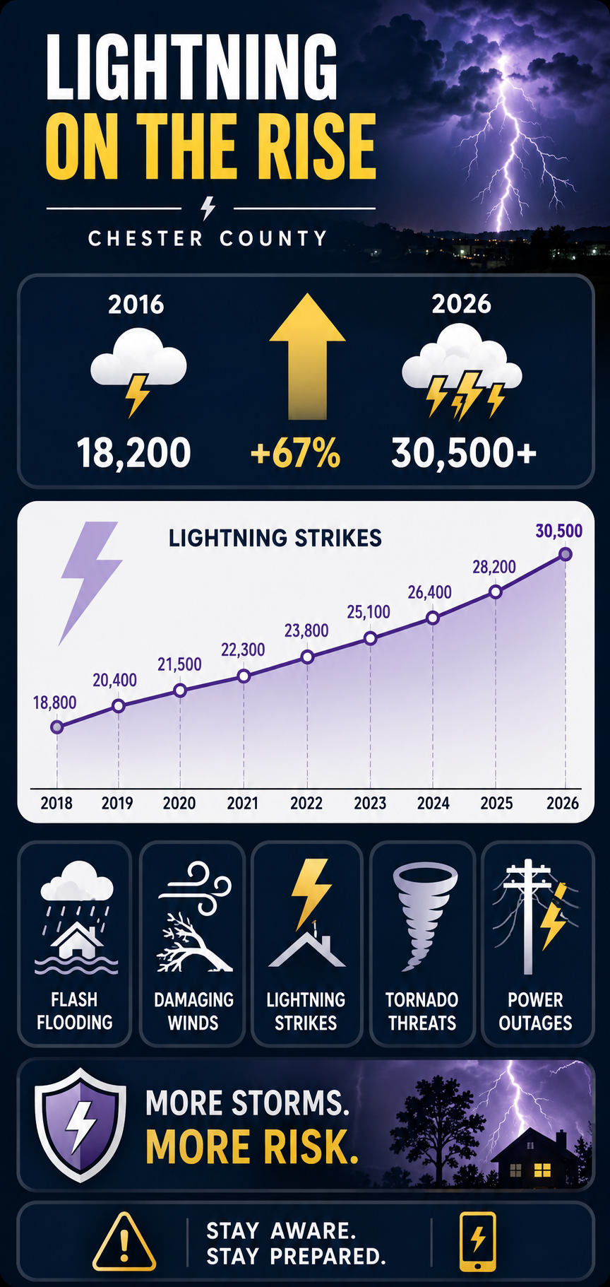
Over the past decade, the number of lightning strikes has increased dramatically, rising from approximately 18,200 in 2016 to more than 30,000 in 2026.

That represents an increase of roughly 67% in just ten years.

⚡ The 10-Year Lightning Surge

YearLightning Strikes
201818,800
201920,400
202021,500
202122,300
202223,800
202325,100
202426,400
202528,200
202630,500

The numbers show a persistent upward pattern.

From 18,800 strikes in 2018 to 30,500 in 2026, lightning activity increased by approximately 62%.

And the increase has not been confined to a single year.

The progression is remarkably consistent:

18,800 → 20,400 → 21,500 → 22,300 → 23,800 → 25,100 → 26,400 → 28,200 → 30,500

That is an increase of approximately 11,700 strikes over the period represented in the table.

The question is:

Why?

A Warmer Atmosphere Is More Electrically Active

Lightning does not occur randomly.

It is produced by powerful thunderstorms, and thunderstorms require energy.

As global temperatures rise, the atmosphere can hold more moisture. The Clausius-Clapeyron relationship indicates that the atmosphere can hold approximately 7% more water vapor for every 1°C (1.8°F) increase in temperature.

More moisture means more potential latent energy available to developing thunderstorms.

Combine that moisture with heat, instability, and the right atmospheric dynamics, and the result can be explosive convection.

That convection creates the enormous vertical clouds in which water droplets, ice crystals, and hail particles collide.

Those collisions help separate electrical charges.

Eventually, the electrical potential becomes strong enough to discharge.

Lightning.

A flash of electricity is therefore one visible manifestation of energy being transferred through the atmosphere.

The Science Behind the Trend

Peer-reviewed atmospheric research published in Science has projected that cloud-to-ground lightning strikes in the contiguous United States could increase by approximately 12% for every 1°C of global warming, with an uncertainty of roughly ±5%.

Under the warming scenario examined in that research, the projected increase could produce approximately a 50% increase in U.S. lightning by the end of the century.

The exact response varies by region and atmospheric conditions, so a national projection should not be interpreted as a precise forecast for Chester County.

But the underlying physical relationship is important:

More heat + more atmospheric moisture + instability = greater potential for powerful thunderstorms.

And thunderstorms are the engines that generate lightning.

About Last Night

September 1, 2026

The numbers become much more tangible when a major storm moves through your own neighborhood.

On Tuesday night, September 1, 2026, the Philadelphia region was hit by a major outbreak of severe thunderstorms.

A dangerous combination of high heat, intense humidity, and a passing cold front helped generate widespread severe weather across the Delaware Valley.

The storm system produced:

⚡ Frequent lightning
🌧️ Torrential rainfall
🌊 Flash flooding
🌬️ Destructive straight-line winds
🌪️ Tornado warnings
🔌 Widespread power outages

The National Weather Service issued repeated severe-weather warnings as the storm line moved across southeastern Pennsylvania, northern Delaware, and southern New Jersey.

Chester County was among the hardest-hit areas in southeastern Pennsylvania.

Lightning Strikes Twice

During the peak of the September 1 storm, Chester County was bombarded by thousands of lightning strikes.

The broader storm line was averaging more than 400 lightning strikes every 15 minutes as it moved through the region.

That translates to an extraordinary rate of electrical activity:

400+ strikes

every 15 minutes

during the storm’s peak intensity.

The electrical activity was accompanied by destructive winds, heavy rainfall, flooding, emergency responses, structural damage, and widespread grid failures.

This is what a lightning trend looks like when it stops being a number on a chart and starts happening over your house.

Local Damage and Emergency Responses

The continuous cloud-to-ground lightning triggered emergency responses throughout Chester County.

Valley Township

Emergency crews responded to reports of a residential home struck by lightning in the 100 block of South Park Avenue.

The strike reportedly split a massive tree, sending it into the structure.

West Goshen

Fire units responded to the 300 block of Mackenzie Drive after a house was reportedly struck directly by lightning.

The strike generated heavy smoke in the basement.

Grid Destruction

Lightning was only one component of the electrical and infrastructure damage.

The storm also produced destructive straight-line wind gusts reportedly reaching up to 80 mph.

Trees and utility poles were damaged or knocked down, contributing to widespread power failures.

At one point, Chester County experienced more than 29,000 concurrent power outages, making it the hardest-hit county in southeastern Pennsylvania.

The Storm Was Bigger Than Lightning

Lightning gets the attention because we can see it.

But lightning is only one expression of the energy contained within a severe thunderstorm.

The same atmospheric system can produce:

⚡ Electrical discharge
🌧️ Extreme rainfall
🌬️ Straight-line winds
🌪️ Tornadoes
🧊 Hail
🌊 Flash flooding
🔌 Grid failures

The atmosphere is continually transforming and redistributing energy.

Solar energy heats the surface.

Heat drives evaporation.

Evaporation transfers energy into water vapor.

Water vapor rises.

Condensation releases latent heat.

That released energy strengthens convection.

Convection builds thunderstorms.

Inside those storms, electrical charges separate.

And eventually—

FLASH!

The energy reaches the ground.

A Shocking Ten-Year Trend

The most striking feature of the lightning data is not one enormous year.

It is the persistent upward movement.

2018 — 18,800

2019 — 20,400

2020 — 21,500

2021 — 22,300

2022 — 23,800

2023 — 25,100

2024 — 26,400

2025 — 28,200

2026 — 30,500

The trend moves steadily upward.

Over the period shown, annual lightning strikes increased by approximately 62%.

Using the earlier 2016 figure of approximately 18,200 strikes, the increase to more than 30,000 in 2026 is approximately 67%.

That is a remarkable change over a single decade.

What Does Climate Change Have to Do With It?

One storm cannot prove climate change.

Natural weather variability is enormous.

Nor can the lightning numbers alone establish that every additional strike was caused by global warming.

But climate change changes the atmospheric background in which thunderstorms develop.

A warmer atmosphere can contain more water vapor.

More water vapor means more latent energy.

Greater heat and moisture can contribute to greater atmospheric instability.

And when the atmospheric ingredients come together, thunderstorms can become more intense.

That creates the potential for more extreme manifestations of atmospheric energy—including lightning.

The important question is therefore not simply:

“Did climate change cause last night’s lightning?”

The more important question is:

“How is a warmer and increasingly moisture-loaded atmosphere changing the conditions under which severe thunderstorms develop?”

That is the climate question.

Chester County, It’s Shocking

Global warming is often discussed in terms of fractions of a degree.

1°C.

1.5°C.

2°C.

Those numbers can seem distant and abstract.

But the atmosphere translates temperature changes into physical processes.

Heat becomes moisture.

Moisture becomes instability.

Instability becomes convection.

Convection becomes thunderstorms.

Thunderstorms become lightning, torrential rain, destructive winds, flooding, and power failures.

And sometimes that energy comes directly into your neighborhood.

30,500 lightning strikes in 2026.

More than 29,000 simultaneous power outages.

80-mph wind gusts.

Flooding.

Damaged homes.

Fallen trees.

Emergency responders racing into the night.

This is how climate energy becomes local.

It doesn’t remain on a graph.

It hits the ground.

And in Chester County—

it’s shocking.

bookmark_borderHow Is Climate Energy Hitting You? Greenland: Gigatons Gone

by Daniel Brouse

Greenland: 6,205 Gigatons of Ice Gone—and the Energy Behind It

Thirty Years of Continuous Ice Loss

Greenland’s Ice Sheet has now experienced 30 consecutive years of negative total mass balance.

According to the Geological Survey of Denmark and Greenland (GEUS), the Greenland Ice Sheet lost approximately 173 billion tonnes (173 Gt) of ice during the 2025/26 melt year. Since the 1996/97 melt year, every year has ended with Greenland losing more ice than it gained from snowfall and other accumulation. GEUS describes this uninterrupted 30-year sequence as a climate signal, rather than simply a collection of independent weather anomalies.

The longer record is even more striking.

From 1986/87 through 2025/26, Greenland lost approximately:

6,205 Gt of ice

That loss contributed approximately:

17.4 millimeters of global sea-level rise.

GEUS estimates that if the entire Greenland Ice Sheet were eventually lost, global sea level would rise by approximately 7.4 meters.

One year’s loss can be strongly influenced by weather. Thirty consecutive years with a negative mass balance tell a very different story.

The signal is persistent. The system has changed. And that brings us to the question:

Where Is the Energy Going?

The Greenland Ice Sheet can be understood not simply as a giant frozen thermometer, but as an enormous energy-processing component of the climate system.

Energy enters the climate system continuously.

It can be:

  • reflected
  • absorbed
  • stored
  • transported
  • converted between sensible and latent forms
  • moved by atmospheric circulation
  • transferred between the atmosphere, ocean, snow, and ice
  • used to melt ice
  • used to evaporate water
  • released again when water freezes or condenses

Greenland sits directly inside this planetary energy-transfer system.

When additional energy reaches the ice sheet, the consequences do not stop at a thermometer reading. Energy can change the temperature of the air, alter precipitation from snow toward rain, melt the surface, increase runoff, transform the snowpack, accelerate glacier flow, and ultimately transfer freshwater from the land to the ocean.

The ice is where some of the energy leaves a fingerprint.

Climate change is not simply about a warmer atmosphere. It is about where the excess energy goes—and what happens when the climate system has to process it.

The Energy Required to Melt 6,205 Gigatons of Ice

To simply convert 6,205 gigatons (Gt) of ice at 0°C into liquid water at 0°C requires approximately 2.05 × 10²¹ joules of thermal energy—or about 2,052 exajoules (EJ).

This calculation uses the latent heat of fusion of ice, approximately 3.34 × 10⁵ joules per kilogram (J/kg).

In other words, the loss of 6,205 Gt of Greenland ice represents an enormous amount of energy that had to be absorbed to accomplish the phase change from solid ice to liquid water—without even accounting for the additional energy required to warm the ice to 0°C or the energy involved in evaporation and other processes.


Greenland Is Part of a Larger Energy Network

Greenland is also connected to the North Atlantic atmosphere-ocean system.

When ice melts and freshwater leaves the ice sheet, it ultimately enters the ocean. That freshwater can influence ocean salinity and density, particularly in the North Atlantic. Changes in density can affect ocean circulation, while ocean circulation transports heat around the planet.

The potential chain is therefore:

Energy → Greenland ice loss → freshwater → density gradients → ocean circulation → heat transport → atmospheric circulation

The important point is not that every Greenland melt event automatically triggers a major circulation change. It doesn’t. The point is that Greenland’s mass loss is coupled to other components of the climate system.

A change in one reservoir can propagate through the network.

That is a teleconnection.


Atmospheric Rivers: When the Energy Arrives by Pipeline

One of the most fascinating examples involves atmospheric rivers (ARs).

Atmospheric rivers are long, narrow corridors that transport enormous quantities of water vapor through the atmosphere. For Greenland, they can be both beneficial and destructive. An atmospheric river can deliver snowfall and temporarily increase the ice sheet’s mass.

But when the transported air is sufficiently warm, the same moisture conveyor can deliver rain, clouds, heat, and intense melt conditions.

The result is a remarkable paradox:

The same atmospheric phenomenon can feed the ice sheet with snow—or attack it with heat and rain.

Research has demonstrated a particularly important connection in northeast Greenland: atmospheric rivers striking northwest Greenland can generate foehn winds downstream in northeast Greenland. These warm, dry downslope winds can produce extreme melting.

Near low-elevation outlet glaciers, researchers found that 80–100% of extreme melt occurred during foehn conditions, while 50–75% occurred during atmospheric-river conditions. The researchers also found that these combined AR-foehn events have become more frequent during the 21st century.

This is climate energy being transported thousands of kilometers and then converted into melt.


The Foehn Effect: Energy Transformed by Topography

The mechanism is beautifully simple. An atmospheric river approaches Greenland carrying warm, moisture-rich air. The air is forced upward as it encounters the ice sheet.

As it rises:

Moisture condenses → precipitation occurs → latent heat is released

The air then crosses the ice divide and descends on the opposite side. As it descends, it becomes warmer and drier.

The result is a foehn wind.

The atmospheric river has effectively transported energy toward Greenland and then, through topography and phase changes, transformed that energy into a powerful downslope heating mechanism.

A 2014 event provides a striking example. An atmospheric river reached northwest Greenland and subsequently produced foehn conditions in northeast Greenland. Modeling estimated approximately 19 Gt of surface melt in northeast Greenland over several days.

This is more than weather.

It is energy being rerouted through the climate system.


The Arctic Moisture Pipeline Is Changing

A warmer atmosphere can carry more water vapor.

The Clausius-Clapeyron relationship tells us that, near Earth’s surface, the atmosphere’s water-vapor-holding capacity increases by roughly 7% per °C of warming, assuming other conditions remain comparable.

That matters enormously for atmospheric rivers. A warmer ocean can provide more moisture. A warmer atmosphere can transport more moisture. And a warmer atmosphere raises the freezing level, increasing the probability that precipitation arrives as rain rather than snow at elevations where snow historically dominated.

The result is a potentially dangerous combination:

More moisture + more heat + higher freezing levels + extreme precipitation

Greenland has already provided a dramatic example.

On August 14, 2021, rain fell at Summit Station, approximately 3,216 meters—or 10,551 feet—above sea level. Temperatures remained above freezing for about nine hours. The National Snow and Ice Data Center reported that there had been no previous report of rainfall at that location.

The thermal and hydrological boundaries of Greenland are changing.


Rain Does More Than Add Water

Rain falling on a cold ice sheet is not simply water falling onto ice. It can alter the physical structure of the snowpack.

When meltwater or rain penetrates the snow and firn and subsequently refreezes, it releases latent heat. Repeated melt-and-refreeze events can create dense ice layers and alter the permeability of the firn.

Research has shown that extreme melt seasons can produce extensive ice layers that reduce firn permeability and change how efficiently the snowpack can retain subsequent meltwater.

This matters because the snowpack is not merely a white surface. It is also a hydrological storage system.

When that storage capacity is altered, more meltwater can become runoff rather than remaining temporarily stored within the ice sheet.

The energy and water budgets become coupled.


Atmospheric Rivers and the Albedo Feedback

There is another feedback. Fresh snow is highly reflective. As snow grains become larger, wetter, older, or contaminated with impurities, the surface generally becomes less reflective. That means more incoming solar radiation is absorbed.

Consider the simplified energy balance:

Fresh snow: albedo ≈ 0.85–0.90

Only about 10–15% of incoming sunlight is absorbed.

If the effective albedo falls to approximately 0.60, about 40% is absorbed.

That represents roughly 2.7 times as much absorbed solar energy as a surface with an albedo of 0.85, all else being equal.

If bare glacier ice with an albedo near 0.40 becomes exposed, approximately 60% of incoming sunlight is absorbed—about four times as much as the 0.85-albedo fresh snow surface.

Darker surface → more absorbed solar energy → more melting → darker surface.

That is an albedo feedback.


The Coupled Feedback

An intense atmospheric-river event can therefore initiate a sequence such as:

Warm, moisture-rich air

↓

Rain / melt / cloud changes

↓

Snowpack transformation

↓

Refreezing and ice-layer formation

↓

Reduced snowpack permeability

↓

More efficient runoff under some conditions

↓

Snow loss and exposure of darker surfaces

↓

Lower albedo

↓

More absorbed solar energy

↓

More melting

Extreme melt events can leave the ice sheet physically different after the storm has passed, potentially affecting its response to subsequent weather and sunlight. Research on Greenland extreme melt events has specifically identified reduced albedo and persistent surface changes as mechanisms that can compound subsequent melt.

The storm can therefore be more than a temporary disturbance.

It can become a conditioning event.


Are Atmospheric Rivers Accelerating Greenland’s Ice Loss?

Yes—atmospheric rivers are an important driver of extreme Greenland melt, particularly when they interact with foehn winds.

Greenland’s total mass balance reflects multiple processes:

  • snowfall
  • surface melting
  • meltwater runoff
  • refreezing
  • glacier acceleration
  • iceberg calving
  • ocean interactions
  • atmospheric circulation
  • long-term warming

Atmospheric rivers can affect several of these processes.

A recent analysis of Greenland’s surface mass balance found that the contribution of atmospheric rivers increased over successive five-year periods, reaching 48.2% during 2015–2019.


From Meltwater to Sea-Level Rise

Greenland’s ice loss becomes a global problem when ice that was stored on land becomes water in the ocean.

There are two major components of Greenland’s mass loss:

Surface mass loss

Snow and ice melt → meltwater runs off → freshwater reaches the ocean.

Dynamic mass loss

Ice flows toward the coast → icebergs calve → land-based ice is transferred to the ocean.

Together, these processes determine Greenland’s total mass balance.

GEUS estimates that Greenland lost approximately 6,205 Gt between 1986/87 and 2025/26, contributing approximately 17.4 mm to global mean sea level.

That is not a theoretical future consequence.

It is already in the ocean.


The Bigger Picture

Greenland contains enough ice to raise global sea level by roughly 7.4 meters if the entire ice sheet were lost. That is not a prediction that Greenland will suddenly disappear.

It is the size of the reservoir we are dealing with.

The more immediate issue is the continuing contribution to sea-level rise.

NASA estimates that roughly one-third of present-day global sea-level rise comes from Greenland and Antarctica combined, with Greenland and Antarctica expected to become increasingly important contributors in the future.

And GEUS has now documented something difficult to dismiss as ordinary weather:

30 consecutive years of negative total mass balance.

Thirty years.

A full climatological reference period.

Every year ending with less ice than the year before.


HOW IS CLIMATE ENERGY HITTING YOU?

This is the deeper lesson from Greenland.

Climate energy does not simply sit in the atmosphere as a higher temperature.

It moves.

It transforms.

It travels through atmospheric rivers.

It condenses.

It releases latent heat.

It becomes sensible heat.

It changes precipitation.

It melts snow.

It transforms the firn.

It exposes darker surfaces.

It increases solar absorption.

It produces runoff.

It moves ice toward the ocean.

And eventually, some of that energy-driven transformation appears on coastlines thousands of miles away as higher sea levels.

Greenland is therefore not merely a frozen landscape responding to a warmer planet.

It is an enormous energy reservoir and processing system embedded within a planetary network of atmosphere, ocean, ice, and water.

The 6,205 gigatons already lost are the accounting entry.

The atmospheric rivers, heat, rainfall, melting, runoff, circulation, and ocean response are the transactions.

And the climate system keeps moving the energy around.

The question is no longer whether the energy exists.

The question is where it goes next—and what it hits.