by Daniel Brouse
Introduction
Straight-line winds are among the most destructive weather hazards on Earth, yet they often receive far less public attention than tornadoes and hurricanes. These powerful, non-rotational winds can flatten forests, rip roofs from buildings, topple power lines, and cause widespread infrastructure failures. In many cases, the damage resembles the aftermath of a tornado or even a hurricane.
Unlike tornadoes, which concentrate damage within a rotating vortex, straight-line winds can devastate broad regions simultaneously. Wind speeds frequently exceed 70–100 mph and, in extreme cases, may surpass 140 mph. Because they can strike with little warning and affect large geographic areas, straight-line wind events represent a growing hazard to communities, transportation systems, utilities, and the insurance industry.
Emerging research indicates that climate change is altering the atmospheric ingredients that produce severe convective storms. As the atmosphere warms and stores more energy, straight-line wind events are becoming more frequent, more destructive, and increasingly widespread. These changes are transforming severe convective storms into one of the fastest-growing sources of weather-related economic losses in the United States.
What Are Straight-Line Winds?
Straight-line winds are powerful horizontal winds that move outward from their source without rotating. They are most commonly produced by the downward plunge and subsequent outward surge of rain-cooled air from severe thunderstorms.
Unlike tornadoes, which draw air inward and rotate violently around a central vortex, straight-line winds push air exclusively outward along the ground. Despite this difference, their destructive potential can rival or even exceed that of weak-to-moderate tornadoes.
The Lifecycle of a Straight-Line Wind Event
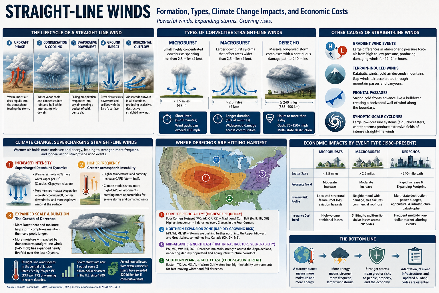
1. Updraft Phase
Warm, moist air rises rapidly into the atmosphere, feeding the development of a growing thunderstorm.
2. Condensation and Cooling
As water vapor ascends, it cools and condenses into rain and hail while interacting with surrounding layers of drier air.
3. Evaporative Downburst Formation
Falling precipitation evaporates into dry air aloft. Because evaporation absorbs heat, it creates a large pocket of extremely cold, dense air.
4. Ground Impact
This dense air mass accelerates downward as a powerful downdraft and collides with Earth’s surface.
5. Horizontal Outflow
Upon impact, the descending air can no longer move downward. Instead, it compresses and surges outward in all directions, producing an explosive burst of destructive straight-line winds.
Classification of Convective Straight-Line Wind Events
Meteorologists classify thunderstorm-generated straight-line winds according to their size and duration.
Microbursts
Microbursts are highly concentrated downbursts spanning less than 2.5 miles (4 km). Although typically lasting only five to ten minutes, they can produce sudden wind gusts exceeding 100 mph and are particularly dangerous because of their intensity and lack of warning.
Macrobursts
Macrobursts are larger downburst systems that spread destruction across areas wider than 2.5 miles (4 km) and often persist significantly longer than microbursts.
Derechos
Derechos are massive, long-lived convective storm systems that produce continuous swaths of wind damage extending at least 240–250 miles (385–400 km). By definition, derechos generate sustained winds of at least 58 mph, with gusts commonly ranging between 75 and 150 mph.
Other Causes of Straight-Line Winds
Although convective downbursts are the most common source of straight-line winds, meteorologists classify any non-rotational horizontal wind as a straight-line wind, regardless of its origin.
Gradient Wind Events
These winds arise from large differences in atmospheric pressure. Air naturally flows from areas of high pressure toward low pressure. When powerful pressure systems are positioned close together, the resulting pressure gradient can accelerate air to damaging speeds. Unlike thunderstorm downbursts that last only minutes, gradient wind events can persist for 12 to 24 hours or longer.
Terrain-Induced Winds
Mountain landscapes frequently create severe straight-line winds.
Katabatic Winds: Cold, dense air descends from elevated plateaus or ice sheets under the influence of gravity, accelerating dramatically before spreading across valleys below.
Examples include:
- Santa Ana winds in California
- Bora winds in southeastern Europe
Gap Winds: Air masses forced through narrow mountain passes and canyons become compressed and accelerated, producing intense horizontal wind speeds.
Frontal Passages
The leading edge of a strong cold front can generate destructive straight-line winds. As dense cold air advances, it acts like an atmospheric bulldozer, forcing warmer air upward and creating a powerful wall of horizontal wind along the frontal boundary.
Synoptic-Scale Extratropical Cyclones
Large non-tropical low-pressure systems, such as Nor’easters and major winter storms, produce extensive fields of intense straight-line winds through tightly packed pressure gradients extending across hundreds of miles.
Climate Change and the Intensification of Straight-Line Winds
Climate change directly influences the atmospheric variables that fuel severe convective storms, causing thunderstorm-generated straight-line winds to become more frequent, intensely destructive, and geographically expanded.
Research synthesized by Climate Central and peer-reviewed studies published in Nature indicates that straight-line wind speeds across portions of the central United States have already intensified by approximately 7% per 1°F (13% per 1°C) of atmospheric warming during recent decades.
Several physical mechanisms are driving these changes.
1. Increased Intensity: Supercharged Downburst Dynamics
The fundamental engine behind a straight-line wind event is the evaporative downburst. Climate change amplifies this process in multiple ways.
Higher Atmospheric Moisture Capacity
According to the Clausius-Clapeyron relationship, a warmer atmosphere can hold approximately 7% more water vapor for every 1°C increase in temperature. This additional moisture allows thunderstorms to contain substantially greater amounts of precipitation.
Enhanced Evaporative Cooling
When this larger volume of precipitation falls through relatively dry layers of air, evaporation occurs more rapidly. The evaporation dramatically cools the descending air, making it denser and heavier than its surroundings.
The greater the temperature contrast between the chilled downdraft and the surrounding environment, the faster the air accelerates downward. The result is a more violent impact at the surface and stronger, more destructive straight-line wind speeds.
2. Increased Frequency: Greater Atmospheric Instability
Severe convective storms require highly unstable atmospheric conditions.
Elevated Convective Available Potential Energy (CAPE)
Warmer temperatures and increased humidity elevate Convective Available Potential Energy (CAPE), a measure of the energy available for thunderstorm development.
More Severe Storm Environments
Advanced climate models consistently project increases in high-CAPE environments under continued greenhouse gas forcing. These environments provide more opportunities for ordinary thunderstorms to intensify into severe systems capable of producing damaging straight-line winds.
3. Expanded Scale and Duration: The Growth of Derechos
Climate change also appears to be altering the longevity and geographic footprint of large convective systems.
Longer-Lived Storm Complexes
A warmer atmosphere contains greater amounts of latent heat and moisture, enabling storm systems to maintain their rain-cooled cold pools for longer periods. Because these cold pools drive storm propagation, straight-line wind events can persist over hundreds of miles.
Fivefold Geographic Expansion
Research summarized by Climate Attribution indicates that the total area affected by thunderstorm-generated straight-line winds exceeding 45 mph has expanded nearly fivefold during the past forty years. Regions farther north and east that historically experienced fewer severe wind events are increasingly experiencing high-intensity derecho systems.
The Severe Convective Storm Crisis
The financial consequences of straight-line winds have fundamentally changed since 1980. Driven by climate change, expanding development patterns, and inflation, severe convective storms have become the most frequent billion-dollar disaster category in the United States.
According to Climate Central, severe storms now account for approximately one out of every two billion-dollar weather disasters recorded since 1980. Annual insured losses from severe convective storms that generally remained below $5 billion during the 1980s have evolved into an eleven-year streak of annual losses exceeding $20 billion.
Comparing Straight-Line Wind Types and Their Economic Impacts
| Characteristic | Microbursts | Macrobursts | Derechos |
|---|---|---|---|
| Spatial Scale | <2.5 miles | >2.5 miles | >240-mile continuous damage path |
| Frequency Trend Since 1980 | Moderate increase | Moderate increase | Rapid increase and expanding footprint |
| Primary Risk Profile | Localized structural failure, aviation hazards, roof losses | Neighborhood-wide damage and extensive tree failures | Multi-state infrastructure destruction and widespread power outages |
| Insurance Cost Trend | High-volume attritional losses | Increasing multi-million-dollar localized losses | Frequent multi-billion-dollar catastrophe events |
Economic Impacts by Event Type
Microbursts and Macrobursts: The Aggregate Loss Problem
Microbursts and macrobursts generally function as localized “attritional losses” for the insurance industry. Individually, most events do not exceed catastrophe thresholds. However, their increasing frequency means they collectively generate billions of dollars in annual claims.
As residential development has expanded into previously rural areas, localized downbursts increasingly strike populated communities. The financial impact often manifests through:
- Roof replacements
- Siding damage
- Broken windows
- Vehicle losses
- Fallen tree claims
- Localized business interruptions
Although these events rarely dominate national headlines, their cumulative economic impact has become enormous.
Derechos: The Multi-Billion-Dollar Market Shifters
Derechos represent the fastest-growing financial threat among straight-line wind events.
Geographic Expansion
Greater atmospheric moisture allows derecho complexes to maintain their structure over much longer distances. Storms increasingly extend into regions where infrastructure and housing stock were not designed to withstand sustained horizontal winds of 80–110 mph.
Hurricane-Scale Damage
Events such as the 2020 Midwest Derecho, which caused more than $11 billion in damages, demonstrated that a single modern derecho can inflict destruction comparable to that of a major landfalling hurricane.
Consequences frequently include:
- Regional power grid failures
- Agricultural devastation
- Widespread commercial losses
- Transportation disruptions
- Long-duration business interruptions
- Extensive residential destruction
Geographic Shifts in Derecho Risk: Expanding Beyond Traditional Boundaries
The United States Midwest and the Corn Belt are experiencing the most severe impacts and greatest geographic expansion associated with intensifying derechos. Although a climatological “hot zone” for these storms has long existed in the central United States, climate change appears to be altering the environmental conditions that govern their formation and propagation.
Warmer atmospheric temperatures, increased moisture availability, and persistent summer heat domes are creating environments capable of sustaining larger and longer-lived convective systems. As a result, regions that historically experienced relatively infrequent derecho activity are increasingly facing severe straight-line wind events with multi-billion-dollar consequences.
1. The Core “Derecho Alley”: Highest Frequency and Agricultural Exposure
Similar to the nation’s Tornado Alley, a region often referred to as Derecho Alley experiences the highest baseline concentration of derechos in North America, averaging approximately one major event each year.
The Four Corners Hotspot
The area encompassing:
- Southwest Missouri
- Northwest Arkansas
- Northeast Oklahoma
- Southeast Kansas
records the highest historical frequency of derechos, averaging roughly four major events every three years.
The Traditional Corn Belt
Immediately east lies the traditional Corn Belt, including:
- Iowa
- Illinois
- Indiana
- Ohio
These states possess extensive flat terrain and some of the world’s most productive agricultural land. The lack of significant topographic barriers allows derecho complexes to accelerate and maintain their structure over hundreds of miles with minimal disruption.
The consequences can be enormous. A single derecho may flatten millions of acres of corn and soybeans within hours, producing severe agricultural losses, disrupting supply chains, damaging grain storage and transportation infrastructure, and generating billions of dollars in economic damages.
2. The Northern Expansion Zone: A Rapidly Growing Risk
As atmospheric warming and persistent summer heat increasingly extend farther north, states that once viewed derechos as rare anomalies are experiencing a growing number of severe events.
Impacted States
- Minnesota
- Wisconsin
- Michigan
- South Dakota
Emerging Trends
Strengthening high-pressure systems and expanding zones of atmospheric instability are supporting derecho development farther into the Upper Midwest and Great Lakes regions. Some events are now maintaining sufficient intensity to continue into Canada, affecting:
- Ontario
- Saskatchewan
- Manitoba
This northward expansion represents one of the clearest examples of shifting severe weather boundaries in a warming climate.
3. The Mid-Atlantic and Northeast: High Infrastructure Vulnerability
Although derechos occur less frequently in the eastern United States than in the Plains and Midwest, their societal and economic impacts are often disproportionately large.
Impacted States
- Pennsylvania
- Maryland
- West Virginia
- New Jersey
- Washington, D.C.
Emerging Trends
Historically, the Appalachian Mountains often weakened convective systems moving eastward. However, recent events suggest that increasingly energetic storm complexes are better able to maintain their structural integrity while crossing the mountains.
As a result, damaging straight-line winds are increasingly reaching densely populated metropolitan corridors of the Mid-Atlantic and Northeast.
The consequences include:
- Large-scale electrical grid failures
- Widespread tree damage
- Transportation disruptions
- Telecommunications outages
- Extensive residential and commercial property losses
Because much of the region’s electrical and transportation infrastructure is decades old and designed for historical wind conditions, vulnerability to major derecho events remains exceptionally high.
4. The Southern Plains and Gulf Coast: The Cool-Season Threat
Approximately 70 percent of all derechos occur during the warm season between May and August. However, a secondary corridor remains active during autumn and winter.
Impacted States
- Eastern Texas
- Louisiana
- Mississippi
- Alabama
Emerging Trends
The Gulf of Mexico is supplying increasingly warm and moisture-rich air masses later into the year. These conditions can create highly unstable environments even during winter months, supporting the development of fast-moving cool-season derechos.
Because communities generally associate severe convective storms with spring and summer, winter derechos often arrive with lower public awareness and preparedness, increasing the potential for widespread impacts.
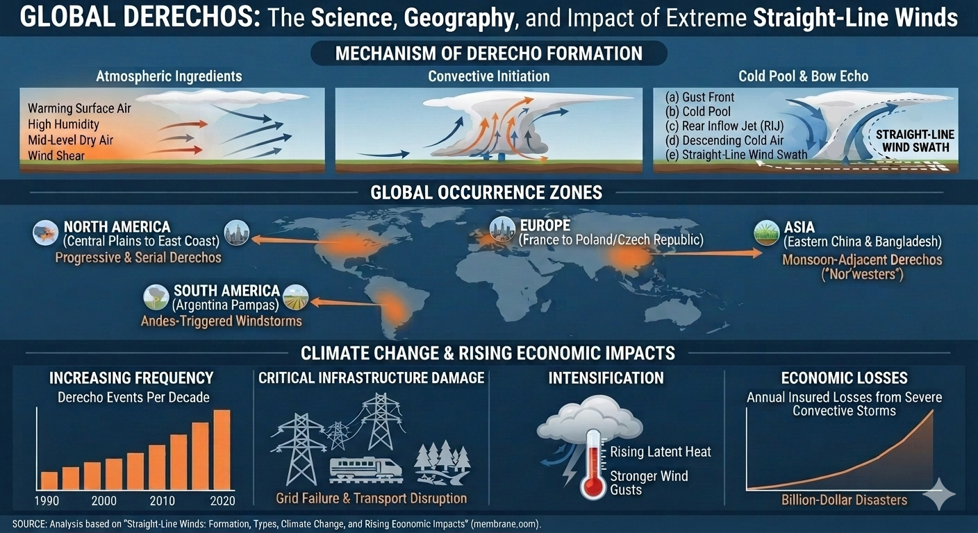
A Global Phenomenon
Although North America experiences some of the world’s most powerful and well-documented derechos, these storms are not unique to the United States. Derecho-like convective systems occur on nearly every continent and are increasingly being recognized in:
- Central Europe
- Eastern Asia
- The subtropical plains of South America
As the global atmosphere continues to warm and store more moisture and energy, researchers are increasingly investigating whether the environmental conditions that support long-lived convective windstorms are becoming more common in regions that historically experienced them only rarely.
The expanding geographic footprint of derechos underscores a central lesson of climate science: severe weather hazards are not remaining stationary. As atmospheric energy increases, the boundaries of extreme events are shifting, exposing new populations, infrastructure, and economic systems to risks that were once considered geographically improbable.
Insurance Industry Responses
Global insured losses from severe convective storms are increasing at an estimated average annual rate of approximately 9%, substantially exceeding the growth rate of losses from other natural catastrophes.
In response, insurers are rapidly restructuring coverage across many regions of the United States.
Traditional policies that once contained flat-dollar wind deductibles are increasingly being replaced by percentage-based wind and hail deductibles ranging from 1% to 5% of a home’s insured value. These changes shift thousands of dollars of immediate disaster costs directly onto homeowners and businesses.
The insurance industry increasingly recognizes straight-line wind events not as isolated weather anomalies but as an emerging systemic risk requiring substantial adjustments in underwriting practices, pricing models, and catastrophe exposure management.
Conclusion: More Energy in the Atmosphere Means More Extreme Winds
Straight-line winds demonstrate a fundamental principle of climate physics: a warmer world is a more energetic world.
As greenhouse gases trap additional heat, the atmosphere stores more moisture and potential energy, creating increasingly favorable conditions for severe convective storms. The result is an environment capable of producing stronger downbursts, more frequent severe thunderstorms, and larger, longer-lived derecho systems.
Climate change does not cause any individual straight-line wind event in isolation. However, it is increasingly altering the environmental ingredients that govern these storms by increasing atmospheric moisture, elevating instability, and supporting more persistent convective systems.
The consequences extend well beyond meteorology. Straight-line winds are becoming a growing challenge for public safety, infrastructure resilience, electrical grid reliability, insurance markets, and building design standards. As the climate system continues to warm, understanding and preparing for these increasingly energetic wind events will become essential for protecting communities and reducing future economic losses.
What are the climate risks where you live?
Many people are surprised to learn that their greatest weather-related risk is often wind damage. Wind and hail damage are among the most common homeowners insurance claims in the United States, accounting for roughly 40% of all property damage claims.
Standard homeowners policies from major insurers generally cover wind damage under dwelling and personal property coverage. These claims can include repairs for roof and shingle damage, siding damage, structural failures, and damage caused by wind-driven debris such as fallen trees.
However, homeowners in high-risk areas—such as coastal regions and “Tornado Alley”—may face separate windstorm deductibles. Unlike a standard fixed deductible (for example, $1,000), these deductibles are often calculated as a percentage of the home’s insured value, typically ranging from 1% to 5%.