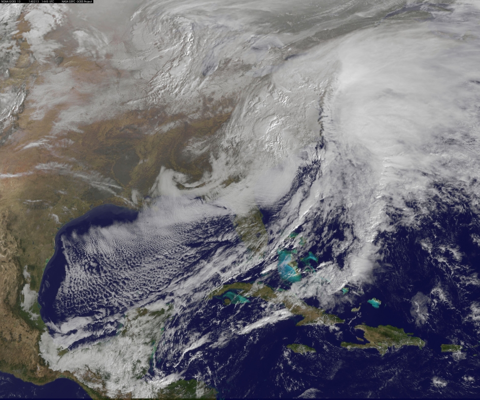
This visible image of the winter storm over the U.S. south and East Coast was taken by NOAA’s GOES-13 satellite on Feb. 13 at 1455 UTC/9:45 a.m. EST. Snow covered ground can be seen over the Great Lakes region and Ohio Valley. Image Credit: NASA/NOAA GOES Project
NASA — The monster winter storm that brought icing to the U.S. southeast moved northward along the Eastern Seaboard and brought snow, sleet and rain from the Mid-Atlantic to New England on February 13. A new image from NOAA’s GOES satellite showed clouds associated with the massive winter storm stretch from the U.S. southeast to the northeast.
Data from NOAA’s GOES-East satellite taken on Feb. 13 at 1455 UTC/9:45 a.m. EST were made into an image by NASA/NOAA’s GOES Project at NASA’s Goddard Space Flight Center in Greenbelt, Md. The clouds and fallen snow data from NOAA’s GOES-East satellite were overlaid on a true-color image of land and ocean created by data from the Moderate Resolution Imaging Spectroradiometer or MODIS instrument that flies aboard NASA’s Aqua and Terra satellites.The image showed that the clouds associated with the storm were blanketing much of the U.S. East Coast.
At 3:11 a.m. EST, a surface map issued by the National Weather Service or NWS showed the storm’s low pressure area was centered over eastern North Carolina. Since then, the low has continued to track north along the eastern seaboard. By 11 a.m. EST, precipitation from the storm was falling from South Carolina to Maine, according to National Weather Service radar.
By 11 a.m. EST, the Washington, D.C. region snow and sleet totals ranged from 3″ in far eastern Maryland to over 18″ in the northern and western suburbs in Maryland and Virginia. NWS reported that snow, sleet and rain were still falling and more snow is expected as the back side of the low moves into the region.
The New York City region remained under an NWS Winter Storm Warning until 6 a.m. on Friday, February 14 and the National Weather Service expects minor coastal impacts Thursday into Friday afternoon.
New England was also being battered by the storm. At 10:56 a.m. EST, Barnstable, Mass. on Cape Cod was experiencing rain and winds gusting to 28 mph. An NWS wind advisory is in effect for Cape Cod until 7 p.m. EST.
Further north, Portland, Maine was experiencing heavy snow with winds from the northeast at 6 mph. The National Weather Service in Gray, Maine noted “Significant snowfall is likely for much of western Maine and New Hampshire as this storm passes by. There will be a mix or changeover to sleet and freezing rain over southern and coastal sections tonight…before all areas end as a period of snow Friday (Feb. 14) morning.”
On February 13 at 10 a.m. EST, NOAA’s National Weather Service noted “An abundance of Atlantic moisture getting wrapped into the storm will continue to fuel widespread precipitation…which should lift through the Mid-Atlantic States and Northeast Thursday into Friday. A wide swath of heavy snow accumulations are expected with this storm…but air [moving] off the warmer ocean water should change snow over to rain along the coastal areas. Also…a narrow axis of sleet and freezing rain will be possible within the transition zone…which is expected to set up near the I-95 corridor.” For updates on local forecasts, watches and warnings, visit NOAA’s www.weather.gov webpage.
GOES satellites provide the kind of continuous monitoring necessary for intensive data analysis. Geostationary describes an orbit in which a satellite is always in the same position with respect to the rotating Earth. This allows GOES to hover continuously over one position on Earth’s surface, appearing stationary. As a result, GOES provide a constant vigil for the atmospheric “triggers” for severe weather conditions such as tornadoes, flash floods, hail storms and hurricanes.
For updated information about the storm system, visit NOAA’s WPC website: http://www.hpc.ncep.noaa.gov/