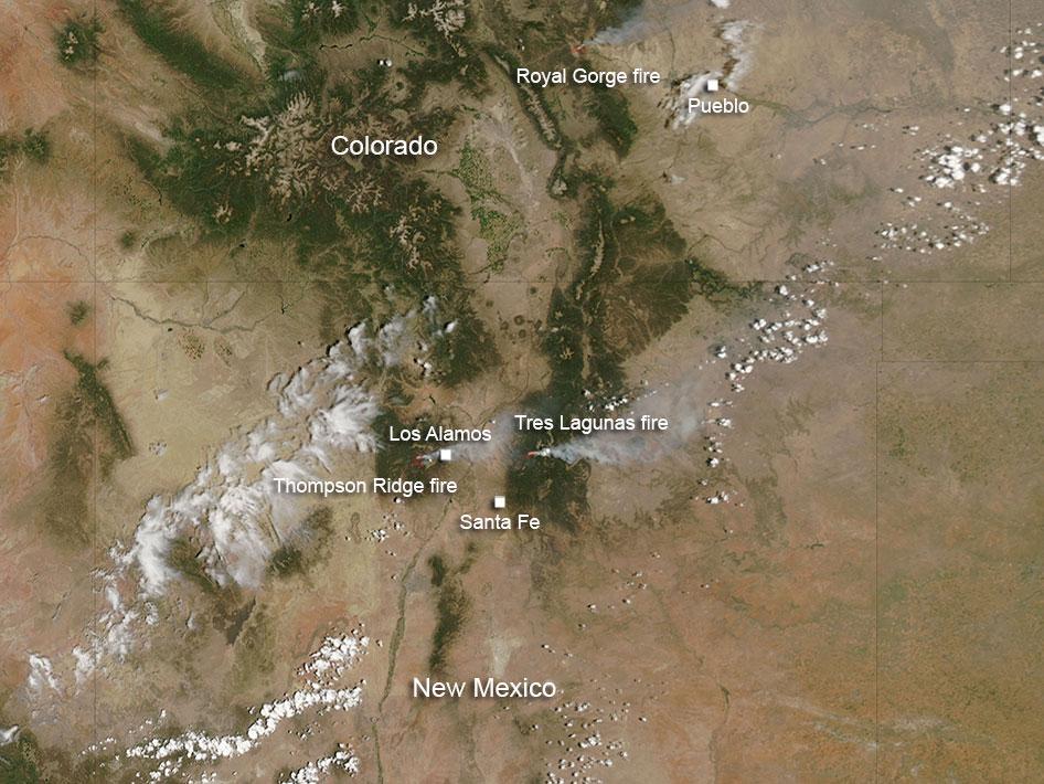
Over 500 homes have been destroyed in the Colorado wildfires. According to NASA: The Royal Gorge fire in Colorado was first reported at 1 p.m. Tuesday June 11, south of the Royal Gorge Bridge and Arkansas River. It is estimated at 3800 acres. At present the Arkansas River has been closed from Spike Buck through Canon City. The Royal Gorge Bridge and Park has been evacuated.
Resources on scene include: 150 firefighters and Law Enforcement officers from both federal and local departments. Resources ordered include: 2-Single Engine Airtanker and 1 Heavy Air Tanker.
The cause of the fire is under investigation.
The New Mexico fires include Thompson Ridge and Tres Lagunas fires. There is another fire in New Mexico south of the area where these fires are located, and that fire is known as the Silver fire. It is not visible in this image, although in the larger image that is included, it is visible.
The Thompson Ridge fire started on May 31, 2013. The cause was human in nature. It is located on the Valles Caldera National Preserve about two miles northeast of La Cueva, New Mexico. The fire is in steep rugged terrain and is burning mixed conifer and ponderosa pine. It has currently burned over 21,000 acres and is 50% contained. However, the growth potential for this fire is high due to rugged terrain, low humidity and dry conditions. Total personnel working this fire is 991.
The Tres Lagunas fire which started on May 30, 2013 was caused by human error and a downed power line. Currently it has burned over 10,000 acres. This fire is 10 miles north of Pecos, New Mexico.
There is a red flag warning for the area today which heralds hot, dry conditions with temperatures remaining well above normal. Stronger and gustier west/southwest winds are expected today with low humidity. All these conditions can contribute to fire growth. At this time the fire is 77% contained.
At present 14 Hand Crews, 5 Helicopters, 17 engines, 2 bulldozers, and 4 water tenders are fighting this fire.
This natural-color satellite image was collected by the Moderate Resolution Imaging Spectroradiometer (MODIS) on June 11, 2013. Actively burning areas, detected by MODIS’s thermal bands, are outlined in red.
NASA image courtesy Jeff Schmaltz, MODIS Rapid Response Team. Caption: NASA/Goddard, Lynn Jenner