by Daniel Brouse
Nepal–Tibet: Glacier Loss, Permafrost Collapse, Glacial Lake Outburst Floods, Flash Floods, Mudslides and Avalanches
Hundreds of people are missing—including hundreds of foreign tourists and pilgrims—after a deadly flash flood struck the Nepal–Tibet border. CCTV footage from Tibet shows a wall of water and mud sweeping into buildings at a border crossing, while images from Nepal show people scrambling to escape as floodwaters surge through the area.
Nepal is a major destination for mountaineers, trekkers, and Hindu and Buddhist pilgrims. Thousands of people travel through the Himalaya each year to visit sacred sites.
August is also a busy season for travelers heading toward Mount Kailash, located in Tibet’s Ngari Prefecture, which is administered by China. The journey from Kathmandu can take roughly 10 days, and thousands of pilgrims cross the Nepal–Tibet border to reach these sacred destinations.
Nepalese tourism officials say hundreds of pilgrims are missing, including more than 100 Indians. The Gyirong–Rasuwagadhi border crossing, a major route between Nepal and Tibet, was struck by a powerful surge of mud and water.
But this disaster is about more than one extreme event.
The Nepal–Tibet Himalayan region sits at the intersection of several climate-sensitive systems: glaciers, snowpack, permafrost, steep mountain slopes, monsoon rainfall, rivers, and glacial lakes. As the region warms, these systems can become increasingly unstable—and their failures can compound one another.
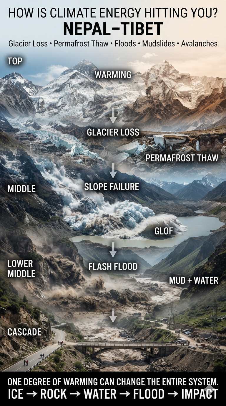
A Mountain System Under Increasing Stress
The Himalaya is warming rapidly, with high-elevation regions experiencing particularly significant changes. Rising temperatures are accelerating glacier loss, altering snow and ice dynamics, thawing permafrost, and increasing the potential for cascading hazards.
The important point is that these hazards do not operate independently.
A warming atmosphere can destabilize a glacier.
A collapsing glacier can trigger an avalanche.
An avalanche can strike a glacial lake.
The resulting displacement wave can breach a natural dam.
The flood can then pick up enormous quantities of rock, soil, and debris as it races downstream.
By the time it reaches a populated valley, what began as warming in the high mountains can become a wall of water, mud, ice, and rock.
Accelerating Avalanches and Permafrost Collapse
Glaciers across the Hindu Kush Himalaya are losing mass rapidly. Retreating glaciers expose unstable terrain while warming temperatures alter the physical structure of ice and frozen ground.
Hanging glaciers can become increasingly unstable. Warmer conditions can promote fracturing and destabilization of ice perched above steep slopes. When large sections collapse, they can generate enormous ice-and-rock avalanches.
Permafrost is another critical component. At high elevations, permanently frozen ground acts like a kind of natural cement holding fractured rock and mountain slopes together. As that frozen ground thaws, the strength of the mountain system can decline.
The result can be slope failures, rockfalls, landslides, and massive collapses into river valleys.
From Glacier Loss to Flash Floods
One of the most dangerous consequences is the increasing potential for glacial lake outburst floods, or GLOFs.
As glaciers retreat, they can leave behind lakes contained by unstable piles of glacial debris called moraines. These natural dams are considerably less predictable than engineered structures.
An avalanche, landslide, or large rockfall entering one of these lakes can displace enormous volumes of water. The resulting wave can overtop or breach the moraine, releasing a sudden flood downstream.
And the flood can become much larger as it moves.
A surge entering a narrow Himalayan valley can pick up boulders, trees, soil, ice, and other debris. What emerges downstream may no longer resemble a conventional flood. It becomes a rapidly moving mixture of water and sediment capable of destroying bridges, roads, buildings, power facilities, and entire communities.
Monsoon Extremes and Mudslides
The other half of the equation is rainfall.
Climate change is altering the hydrological cycle. A warmer atmosphere can hold more water vapor, increasing the potential for extremely intense precipitation when that moisture is released.
The danger is not simply more rain.
It is greater volatility.
Longer dry periods can be followed by exceptionally intense rainfall. When torrential precipitation falls onto already unstable slopes, landslides and mudflows can occur with little warning.
Mountain terrain makes the problem even more severe.
Steep slopes, fractured rock, thawing permafrost, retreating glaciers, and saturated soils create conditions in which enormous quantities of sediment can suddenly move downhill.
Critical transportation corridors are particularly vulnerable. Highways, bridges, tunnels, and hydropower facilities frequently occupy narrow valleys—the same pathways followed by floodwaters and debris flows.
The August 2026 Border Disaster
The current disaster along the Nepal–Tibet border illustrates how these hazards can interact.
Reports indicate that an ice-and-rock avalanche blocked the Lhende River, a tributary of the Bhotekoshi River. A localized magnitude-4.4 earthquake may also have contributed to destabilizing the terrain.
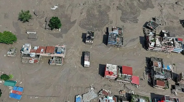
The resulting blockage and subsequent flooding generated a massive surge of water and debris, reportedly producing a mudflow roughly 33 feet high.
The flood destroyed or severely damaged border infrastructure, including the strategic Friendship Bridge, and caused major casualties around Tibet’s Gyirong port.
At least 22 people have been confirmed dead, while hundreds of international tourists and pilgrims remain missing according to reports.
The disaster also damaged Nepal’s electricity infrastructure, temporarily taking a substantial portion of the country’s hydropower capacity offline.
This is an important reminder that climate-driven disasters do not only kill people directly.
They can also disable the infrastructure societies depend upon for transportation, electricity, communications, food distribution, tourism, and emergency response.
The Cascade Is the Story
The most important climate signal here is not any single flood, avalanche, landslide, or rainfall event.
It is the coupling of hazards.
Warming
↓
Glacier loss + snow and ice instability
↓
Permafrost thaw
↓
Unstable mountain slopes
↓
Avalanches and landslides
↓
Glacial lake disruption and river blockages
↓
Extreme rainfall
↓
Flash floods + debris flows + mudslides
↓
Destroyed infrastructure
↓
Disrupted electricity, transportation and tourism
↓
Human casualties
This is what makes the Himalaya particularly vulnerable to a changing climate.
The mountains are not experiencing isolated changes. They are experiencing changes in a tightly connected system.
When one component moves, it can destabilize another.
And when several components move simultaneously, the result can be a cascade.
Climate Energy Is Moving Through the System
The Himalaya is a powerful example of what climate change actually means on the ground.
Climate change does not simply mean that the average temperature rises by a few degrees.
It means that additional energy enters the climate system and changes how water, ice, rock, soil, and atmospheric moisture interact.
In the high Himalaya, that additional energy is destabilizing parts of the cryosphere while increasing the atmosphere’s capacity to transport moisture.
The result is a dangerous combination:
More unstable ice + more unstable ground + more atmospheric moisture + extreme precipitation = greater potential for cascading disasters.
For people living in Himalayan valleys—and for the millions who depend upon these mountains for water, transportation, energy, agriculture, tourism, and cultural traditions—the consequences are becoming increasingly difficult to separate from everyday life.
The question is no longer simply whether climate change is occurring.
The question is:
How is the energy already entering the climate system moving through the landscape—and where will the next cascade begin?