by Daniel Brouse
Between April 1 and 4, Southeastern Pennsylvania experienced another severe weather event attributed to atmospheric rivers and strong winds. Rainfall accumulation exceeded 3 inches, accompanied by wind gusts ranging from 35 to 45 mph. Tragically, two individuals lost their lives in unrelated incidents, one in Montgomery County and the other in Delaware County, when trees collapsed onto their vehicles.
Part of the The Philadelphia Violent Rain Experiment
The Greater Philadelphia Area serves as our focal point for studying non-coastal violent rain events. Although situated 78 miles from the nearest coast, Philadelphia has experienced a surge in violent rainstorms since 2021, with each episode yielding more precipitation than the typical monthly average. In addition to enduring Nor’easters and tropical storms from the Southeast, Philadelphia is increasingly subjected to deluges originating from the Gulf of Mexico.

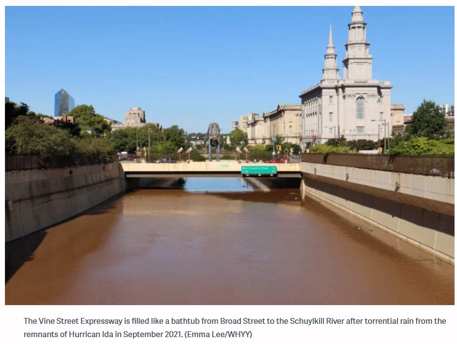
Hurricane Ida in the summer of 2021 is a good example. Because of the 85 degrees Fahrenheit Gulf of Mexico ocean temperature, Ida rapidly gained strength right before it made landfall jumping from a Category 1 to a Category 4 storm. The warm air allowed more moisture to be carried as rain. The storm was so large that it was able to pick up more moisture from the Atlantic Ocean. After destroying parts of Florida, the ocean moisture was carried inland and dumped over places like Pennsylvania and New York. Ida caused record flood damage in parts of Pennsylvania. The Philadelphia Inquirer reported, “The remnants of Hurricane Ida destroyed or damaged hundreds of homes in Southeastern Pennsylvania and caused more than $100 million in public infrastructure damage across the state.” There were more deaths in the Northeastern USA than where the storm made landfall in Louisiana. The New York Times reported, “The remnants of Hurricane Ida caused flash flooding and a number of deaths and disrupted transit across parts of New York and New Jersey. The storm killed at least 43 people in New York, New Jersey, Pennsylvania and Connecticut and left more than 150,000 homes without power.” Ida’s Philadelphia area destruction included 5 deaths, 7 tornadoes, record flooding, hundreds of water rescues, and “one incredibly soggy mess.” The violent rain in Philadelphia was so extreme that the main road across the city from the Delaware River to the Schuylkill River, the Vine Street Expressway, was turned into a canal. “You could’ve swam from 22nd Street to about 15th Street,” said Justin Galbreath, a district maintenance manager at the Pennsylvania Department of Transportation. As climate change intensifies, the frequency of Vine Street becoming a river will likely increase until such time as it becomes permanent.
The train derailment in Plymouth Meeting (July 17, 2023), the eleven vehicles swept away, and the seven people drowned by flood waters in Washington Crossing (July 15, 2023) were caused by a deluge of rain and flash flooding. “In my 44 years, I’ve never seen anything like it,” Upper Makefield Fire Chief Tim Brewer said. “When the water came up, it came up very swiftly. We do not think that anybody drove into it, that they were actively on that road when it happened.” CBS news reported, “Over 6 inches of rain in an hour caused the flash flooding according to Brewer. The fire department was dispatched in that area for a lightning strike and just by happenstance they found 11 cars. Eight people were rescued from the cars and two from the creek.” In July and December of 2023, extreme rainfall resulted in sinkholes being exposed in the carbonate rock under Route 202 in nearby King of Prussia, PA.
In September of 2023, the Philadelphia Inquirer reported, “The remnants of Tropical Storm Ophelia soaked the entire Philadelphia region with episodic downpours on Saturday, the first day of fall, conspiring to incite 60-mph wind gusts at the Shore and high-tide flooding that closed numerous roads in beach and back-bay towns.” There were up to 8 inches of rain recorded throughout the Philadelphia region over the three day event.
The winter of 2023 saw near weekly atmospheric river flash flooding events. On January 9, the Greater Philadelphia Region incurred an historic winter tropical violent rain event. CBS news reported, “If it feels like it’s been an abnormally rainy few weeks, you’re right. Normal rainfall totals between Dec. 1 and Jan. 9 amount to about 4.78 inches. Between December 2023 and Tuesday, we’d already recorded more than 9 inches of rain, an amount normally recorded in December, January and February combined.” The January 9 storm brought over 4 inches of rain to many areas. The Delaware River peaked at its highest level ever. There were hurricane strength winds with wind gusts over 70mph.
On March 23, 2024, Philadelphia witnessed its wettest March day on record. The rain gauge at the airport measured over 3 inches of rainfall, with parts of New Castle County, Delaware, also receiving over 3 inches. Some areas in Gloucester County and Camden County, New Jersey, recorded rainfall exceeding 4 inches. The precipitation observed on that day was roughly equivalent to the typical rainfall for the entire month. A young girl was swept away by the rapidly rising and swift moving waters of the Chester Creek in Delaware County, PA.
On the same day, an atmospheric river event brought heavy rains to Brazil’s Rio de Janeiro state, resulting in at least nine fatalities, with Petropolis being the hardest hit. A staggering 270 mm (11 inches) of rain fell within 24 hours, significantly impacting the region and leading to numerous incidents, including landslides and house collapses.