A strong ridge of high pressure is forecast to build across the eastern United States next week, bringing another round of dangerous heat and humidity to millions of people. In the Philadelphia region, afternoon temperatures are expected to exceed 101°F, while dew points in the 70s will push heat index values even higher. Overnight temperatures will remain in the 70s, providing little opportunity for homes, roads, and the human body to cool down.
This will not be the first heat dome of the season—and it almost certainly will not be the last.
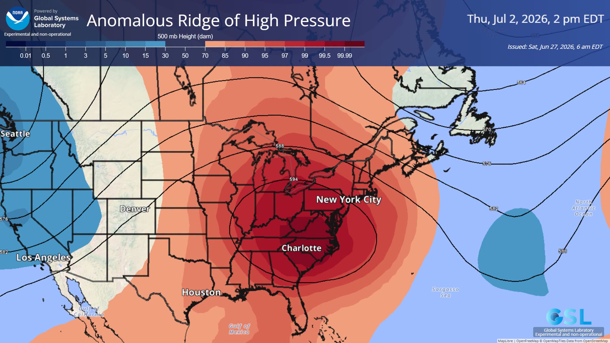
At the moment, the Mid-Atlantic sits beneath a relatively cool, damp trough. Within days, however, the atmosphere will flip into the opposite phase as a powerful upper-level ridge expands overhead. That transition from cool, unsettled weather to oppressive heat is becoming an increasingly familiar pattern.
The Heat Dome
A heat dome develops when a large area of high atmospheric pressure traps warm air beneath it. As the air slowly sinks, it compresses and warms further, suppressing cloud formation and rainfall. Day after day, solar energy accumulates at the surface, causing temperatures to climb steadily higher.
The result is a self-reinforcing cycle:
- Clear skies allow maximum solar heating.
- Drying soils reduce evaporative cooling.
- Hot ground heats the air above it.
- The high-pressure ridge strengthens, trapping even more heat.
The longer the ridge remains stationary, the more intense the heat becomes.
Rossby Waves: Why the Weather Gets Stuck
One of the primary reasons these heat domes are lasting longer is the increasing amplification of Rossby waves—the giant north-south meanders of the jet stream that steer weather systems around the Northern Hemisphere.
Historically, these waves moved relatively quickly from west to east, allowing weather systems to progress every few days. Increasingly, however, the waves are becoming larger, slower, and more persistent.
Instead of quickly moving through, they linger.
When a ridge stalls overhead, intense heat persists. When a trough stalls, regions can experience days or weeks of heavy rain, flooding, or cooler-than-normal weather.
Omega Blocks: Weather That Refuses to Move
One of the most extreme forms of Rossby-wave amplification is known as an Omega Block, named because the jet stream resembles the Greek letter Ω.
In this configuration:
- A massive ridge of high pressure becomes trapped between two deep troughs.
- The normal west-to-east flow nearly stops.
- Weather systems remain locked in place for days or even weeks.
These blocking patterns are responsible for many of the world’s most severe heat waves, prolonged droughts, and catastrophic flood events.
Instead of weather continuously moving across the continent, it effectively becomes parked.
A Global Pattern, Not an Isolated Event
The effects are not limited to North America.
As amplified Rossby waves propagate around the hemisphere, similar blocking patterns often develop simultaneously across Europe, the United Kingdom, Russia, and Asia. While one region endures relentless heat beneath a stalled ridge, another may sit beneath a stationary trough producing days of torrential rainfall.
This is one reason extreme weather increasingly appears synchronized around the globe.
The atmosphere is behaving less like a conveyor belt and more like a series of stalled traffic jams.
The Role of Arctic Amplification
Scientists continue to investigate the extent to which Arctic amplification contributes to changes in Rossby-wave behavior. As the Arctic warms faster than the global average, the temperature contrast between the poles and the tropics is reduced. Because this temperature gradient helps drive the jet stream, a weaker contrast may favor a slower, more meandering circulation under some conditions.
Other large-scale processes—including tropical heating patterns, sea-surface temperature anomalies, land-atmosphere interactions, and Sudden Stratospheric Warming (SSW) events—also influence the jet stream.
Together, these interacting processes contribute to an atmosphere that is increasingly capable of producing persistent weather extremes.
Climatic Whiplash
One of the defining signatures of this changing circulation regime is climatic whiplash—rapid transitions between opposite weather extremes.
Examples include:
- severe drought followed by catastrophic flooding;
- prolonged heat waves followed by unusually cold outbreaks;
- stagnant weather giving way to explosive storm development;
- persistent flooding immediately followed by extended dry periods.
These rapid swings are becoming more common because the atmosphere stores more heat and moisture while weather systems increasingly become locked into place before abruptly shifting.
The result is not simply “more extreme weather,” but greater volatility from one extreme to another.
Why Humidity Makes Heat More Dangerous
The upcoming heat wave is especially concerning because of the humidity.
Warm air can hold approximately 7% more water vapor for every 1°C (1.8°F) of warming, a relationship described by the Clausius-Clapeyron equation. As temperatures rise, the atmosphere’s capacity to retain moisture increases dramatically.
Higher humidity reduces the body’s ability to cool itself through evaporation of sweat. Even nighttime temperatures remain elevated because water vapor acts as a greenhouse gas, trapping outgoing heat.
This combination of extreme heat and humidity raises the risk of dangerous wet-bulb temperatures, increases nighttime heat stress, and expands the number of days when outdoor physical activity becomes hazardous.
A New Atmospheric Regime
The atmosphere increasingly appears to be transitioning from a fast-moving, progressive circulation pattern toward a slower, more amplified, and more persistent nonlinear flow regime.
The consequences are becoming increasingly familiar:
- longer-lasting heat domes;
- stalled flooding events;
- prolonged droughts;
- stronger atmospheric rivers;
- more rapid swings between weather extremes; and
- increasing stress on agriculture, infrastructure, ecosystems, and public health.
The upcoming eastern U.S. heat dome is therefore more than just another hot week. It is another example of how changes in large-scale atmospheric circulation are making extreme weather more persistent, more widespread, and more difficult to escape.
Rossby Waves, Climatic Whiplash, and the Nonlinear Destabilization of Atmospheric Circulation