by Daniel Brouse
A Shocking Trend: Lightning Strikes Are Surging Across the Delaware Valley
Lightning is one of the most spectacular—and potentially destructive—ways atmospheric energy reaches the ground.
And the trend in Chester County is striking.
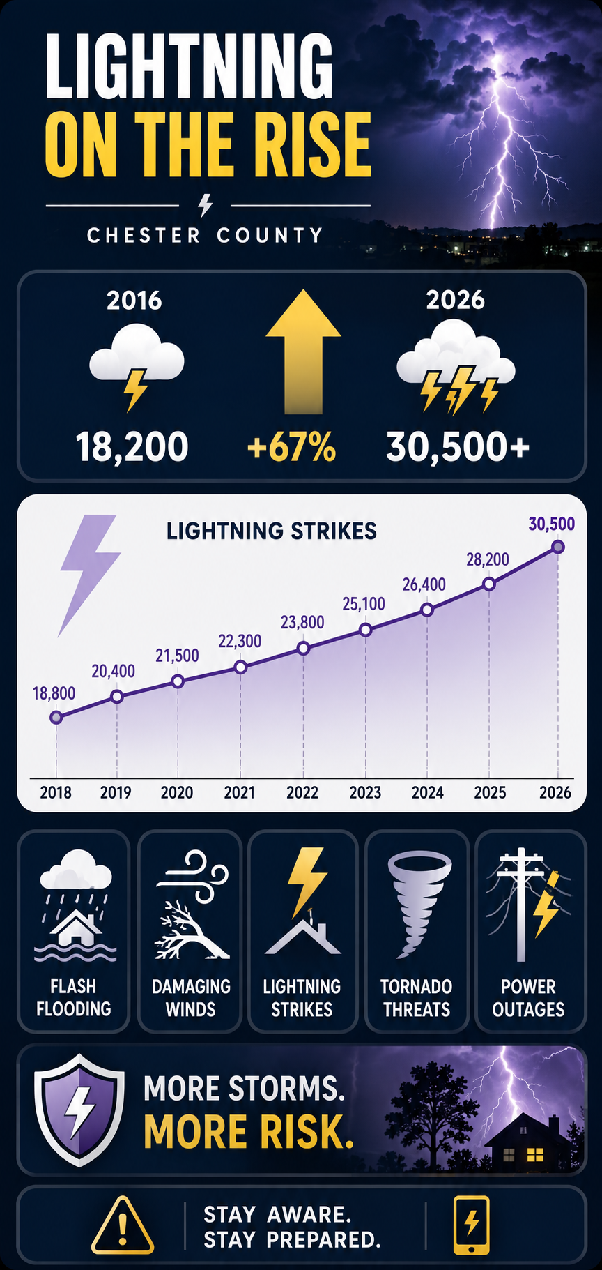
Over the past decade, the number of lightning strikes has increased dramatically, rising from approximately 18,200 in 2016 to more than 30,000 in 2026.
That represents an increase of roughly 67% in just ten years.
⚡ The 10-Year Lightning Surge
| Year | Lightning Strikes |
|---|---|
| 2018 | 18,800 |
| 2019 | 20,400 |
| 2020 | 21,500 |
| 2021 | 22,300 |
| 2022 | 23,800 |
| 2023 | 25,100 |
| 2024 | 26,400 |
| 2025 | 28,200 |
| 2026 | 30,500 |
The numbers show a persistent upward pattern.
From 18,800 strikes in 2018 to 30,500 in 2026, lightning activity increased by approximately 62%.
And the increase has not been confined to a single year.
The progression is remarkably consistent:
18,800 → 20,400 → 21,500 → 22,300 → 23,800 → 25,100 → 26,400 → 28,200 → 30,500
That is an increase of approximately 11,700 strikes over the period represented in the table.
The question is:
Why?
A Warmer Atmosphere Is More Electrically Active
Lightning does not occur randomly.
It is produced by powerful thunderstorms, and thunderstorms require energy.
As global temperatures rise, the atmosphere can hold more moisture. The Clausius-Clapeyron relationship indicates that the atmosphere can hold approximately 7% more water vapor for every 1°C (1.8°F) increase in temperature.
More moisture means more potential latent energy available to developing thunderstorms.
Combine that moisture with heat, instability, and the right atmospheric dynamics, and the result can be explosive convection.
That convection creates the enormous vertical clouds in which water droplets, ice crystals, and hail particles collide.
Those collisions help separate electrical charges.
Eventually, the electrical potential becomes strong enough to discharge.
Lightning.
A flash of electricity is therefore one visible manifestation of energy being transferred through the atmosphere.
The Science Behind the Trend
Peer-reviewed atmospheric research published in Science has projected that cloud-to-ground lightning strikes in the contiguous United States could increase by approximately 12% for every 1°C of global warming, with an uncertainty of roughly ±5%.
Under the warming scenario examined in that research, the projected increase could produce approximately a 50% increase in U.S. lightning by the end of the century.
The exact response varies by region and atmospheric conditions, so a national projection should not be interpreted as a precise forecast for Chester County.
But the underlying physical relationship is important:
More heat + more atmospheric moisture + instability = greater potential for powerful thunderstorms.
And thunderstorms are the engines that generate lightning.
About Last Night
September 1, 2026
The numbers become much more tangible when a major storm moves through your own neighborhood.
On Tuesday night, September 1, 2026, the Philadelphia region was hit by a major outbreak of severe thunderstorms.
A dangerous combination of high heat, intense humidity, and a passing cold front helped generate widespread severe weather across the Delaware Valley.
The storm system produced:
⚡ Frequent lightning
🌧️ Torrential rainfall
🌊 Flash flooding
🌬️ Destructive straight-line winds
🌪️ Tornado warnings
🔌 Widespread power outages
The National Weather Service issued repeated severe-weather warnings as the storm line moved across southeastern Pennsylvania, northern Delaware, and southern New Jersey.
Chester County was among the hardest-hit areas in southeastern Pennsylvania.
Lightning Strikes Twice
During the peak of the September 1 storm, Chester County was bombarded by thousands of lightning strikes.
The broader storm line was averaging more than 400 lightning strikes every 15 minutes as it moved through the region.
That translates to an extraordinary rate of electrical activity:
400+ strikes
every 15 minutes
during the storm’s peak intensity.
The electrical activity was accompanied by destructive winds, heavy rainfall, flooding, emergency responses, structural damage, and widespread grid failures.
This is what a lightning trend looks like when it stops being a number on a chart and starts happening over your house.
Local Damage and Emergency Responses
The continuous cloud-to-ground lightning triggered emergency responses throughout Chester County.
Valley Township
Emergency crews responded to reports of a residential home struck by lightning in the 100 block of South Park Avenue.
The strike reportedly split a massive tree, sending it into the structure.
West Goshen
Fire units responded to the 300 block of Mackenzie Drive after a house was reportedly struck directly by lightning.
The strike generated heavy smoke in the basement.
Grid Destruction
Lightning was only one component of the electrical and infrastructure damage.
The storm also produced destructive straight-line wind gusts reportedly reaching up to 80 mph.
Trees and utility poles were damaged or knocked down, contributing to widespread power failures.
At one point, Chester County experienced more than 29,000 concurrent power outages, making it the hardest-hit county in southeastern Pennsylvania.
The Storm Was Bigger Than Lightning
Lightning gets the attention because we can see it.
But lightning is only one expression of the energy contained within a severe thunderstorm.
The same atmospheric system can produce:
⚡ Electrical discharge
🌧️ Extreme rainfall
🌬️ Straight-line winds
🌪️ Tornadoes
🧊 Hail
🌊 Flash flooding
🔌 Grid failures
The atmosphere is continually transforming and redistributing energy.
Solar energy heats the surface.
Heat drives evaporation.
Evaporation transfers energy into water vapor.
Water vapor rises.
Condensation releases latent heat.
That released energy strengthens convection.
Convection builds thunderstorms.
Inside those storms, electrical charges separate.
And eventually—
FLASH!
The energy reaches the ground.
A Shocking Ten-Year Trend
The most striking feature of the lightning data is not one enormous year.
It is the persistent upward movement.
2018 — 18,800
2019 — 20,400
2020 — 21,500
2021 — 22,300
2022 — 23,800
2023 — 25,100
2024 — 26,400
2025 — 28,200
2026 — 30,500
The trend moves steadily upward.
Over the period shown, annual lightning strikes increased by approximately 62%.
Using the earlier 2016 figure of approximately 18,200 strikes, the increase to more than 30,000 in 2026 is approximately 67%.
That is a remarkable change over a single decade.
What Does Climate Change Have to Do With It?
One storm cannot prove climate change.
Natural weather variability is enormous.
Nor can the lightning numbers alone establish that every additional strike was caused by global warming.
But climate change changes the atmospheric background in which thunderstorms develop.
A warmer atmosphere can contain more water vapor.
More water vapor means more latent energy.
Greater heat and moisture can contribute to greater atmospheric instability.
And when the atmospheric ingredients come together, thunderstorms can become more intense.
That creates the potential for more extreme manifestations of atmospheric energy—including lightning.
The important question is therefore not simply:
“Did climate change cause last night’s lightning?”
The more important question is:
“How is a warmer and increasingly moisture-loaded atmosphere changing the conditions under which severe thunderstorms develop?”
That is the climate question.
Chester County, It’s Shocking
Global warming is often discussed in terms of fractions of a degree.
1°C.
1.5°C.
2°C.
Those numbers can seem distant and abstract.
But the atmosphere translates temperature changes into physical processes.
Heat becomes moisture.
Moisture becomes instability.
Instability becomes convection.
Convection becomes thunderstorms.
Thunderstorms become lightning, torrential rain, destructive winds, flooding, and power failures.
And sometimes that energy comes directly into your neighborhood.
30,500 lightning strikes in 2026.
More than 29,000 simultaneous power outages.
80-mph wind gusts.
Flooding.
Damaged homes.
Fallen trees.
Emergency responders racing into the night.
This is how climate energy becomes local.
It doesn’t remain on a graph.
It hits the ground.
And in Chester County—
it’s shocking.